 |
| (published by Scope Enterprises, Inc) |
My latest project is an exploration of the geologically interesting places in California that don't always show up on the postcards. I'm probably going to be on this for awhile, and I'm needing a page where I can keep track of what I've done so far. If you've followed my blog at all, you know I have a type of
Geologist Attention Deficit Disorder Syndrome (GADDS), that as soon as I start concentrating on one subject, something interesting pops up somewhere else, and I explore it for a few weeks, and then get distracted again.
Geologists divide California into
eleven geomorphic provinces, areas that share unique geologic histories, rock types and topography that are distinct from the surrounding areas. I generally refer to the province when I am describing a particular feature or place. I am categorizing the posts that exist thus far in the same way:
THE INTRODUCTION
The Other California: The Things it is Not: the first post describing what I am up to with this series: most people know about Yosemite, Sequoia, Death Valley and other famous places, but California has so much more...things and places that don't appear on the postcards
THE STATE SYMBOLS
Although the original idea came with a post about
California's prairie lands, I pretty much first started out by describing the geologic significance of some of our state symbols.
THE GREAT VALLEY
A huge 400 mile long valley filled with thousands of feet of sediments deposited over 160 million years, and one of the most fertile agricultural regions in the world
The Prairie Lands: California has its own version of savannahs, both present and past.
The Prairies of the Past: An exploration of the most important Pleistocene fossil quarry in central California, the Fairmead Landfill
THE SIERRA NEVADA
The Sierra Nevada is the largest single mountain range in the United States, more than 400 miles long and averaging 50 miles wide. It also has the highest peak in the lower 48 states. Although composed mostly of granite, it also has large exposures of metamorphic and volcanic rocks that tell a remarkable story of traveling continents and terranes, as well as tales of violent eruptions.
THE CASCADE RANGE
The Cascadia Subduction Zone is a place of geological violence: The crust underlying the Pacific Ocean is sinking beneath the western edge of the North American Continent, producing earthquakes, mountain-building, and volcanism. Two of California's most familiar volcanoes formed here, and the largest volcano in the state sits astride the boundary with the Modoc Plateau
A Monday Mystery: A river that comes out of nowhere, and a gratuitous picture of a deer family
THE MODOC PLATEAU
The Modoc Plateau is a high flat region underlain by thick flows of basalt lavas in the remote northeast corner of the state. It is one of the least-known areas of California, but has some nice geological surprises.
The Volcano Underground: the formation of lava tubes (via a short excursion in Hawaii) and Lava Beds National Monument
Whispers From the Past: Huge explosions from 270,000 years ago, and the largest petroglyph panel in the United States
Cries From the Past: A tale of rebellion, resilience and betrayal; the Modoc Indian War of 1872-73. And why armies should study geology before fighting wars.
THE KLAMATH MOUNTAINS
In northwest California, a series of mountain ridges reveal stories of continental and oceanic fragments that were crushed into the western edge of North America. The rocks bear a close resemblence to the Sierra Nevada, although they are offset more than sixty miles.
Flotsam and Jetsam: An introduction to the Klamath Mountains as a series of accreted terranes, tracts of crust and old ocean floor that traveled hundreds or thousands of miles.
Taking Stock of Castle Crags: One of the most imposing sights (besides Shasta) to be seen on a journey north on Interstate 5, the Castle Crags are towers and domes of granite, surrounded by more easily eroded metamorphic rocks
THE COAST RANGES
The series of mountain ranges that roughly parallel California's coastline are one of most diverse areas of the state from a geologic standpoint. There are thick sequences of sedimentary rocks including the Great Valley Group and elements of the Franciscan Complex, and there are plutonic and metamorphic rocks of the Salinian Block (and parts of the Franciscan). There are even volcanic rocks and potentially active volcanoes.
I Need This Like I Need a Hole in the Head: Scenic Bodega Head at Bodega Bay was the nearly the site of one of the most mind-bogglingly stupid energy developments ever conceived by the minds of engineers
Baymouth Bars - It's Five O'Clock Somewhere? Along the incredibly rugged north coast amid the violent surf there are long, perfectly straight sand bars that seem to defy explanation. They're explained here Humboldt Lagoons State Park
A Mystery Photo For a Saturday: A look at San Francisco from a unique angle, Monte del Diablo
The Thicket of the Devil (the mystery photo revealed): An introduction to a place with an incredible view, Mt. Diablo. How it got its name and why every landowner in Central California should care
Limekiln State Park Part 1,
Part 2, and
Part 3: Limekiln is a beautiful gem of a state park on the Big Sur Coastline. Unfortunately we have morons in the state legislature and this park is closing. See what is being taken from us
Catch it While You Can- The Devil's Slide: You can no longer drive over one of the most notorious rockslides on Highway One. But you can walk it!
BASIN AND RANGE
The crust of the earth east of the Sierra Nevada and Peninsular Ranges is being torn apart by horizontal extensional forces that have produced an alien landscape of deep fault valleys (grabens) and high mountain fault blocks (horsts)
MOJAVE DESERT
Often ignored or tolerated by tourists on their way to Las Vegas, the Mojave Desert is one of the most geologically diverse regions of California
The Calico Mountains: An exploration of a unique mountain range, well beyond the confines of the tourist trap ghost town.
A Wandering Volcano and a Floral Outburst: The Antelope Valley has a springtime show of wildflowers that is simply audacious, and the underlying rocks include half of a volcano. The other half is nearly 200 miles away...
COLORADO DESERT
THE TRANSVERSE RANGES
A diverse series of mountain ranges that run against the grain, trending east-west instead of north-south. These include some of the highest mountains in southern California
Scarps to the Left of Me, Sag Ponds to the right, Here I am, Stuck in the Middle with You!: The San Andreas fault cuts across many of California's province. In this post we look at some fault features at the top of the Grapevine in the Transverse Ranges
A Monday Mystery Photo: A quick introduction to the Cajon Pass country where the San Andreas fault splits the San Gabriel Mountains from the San Bernardino Mountains
Cajon Pass and No Strange Sci-Fi Creatures: Cajon Pass, the major freeway access route into the Los Angeles basin, is filled with strange looking sedimentary rocks tilted this way and that. But it's not where Captain Kirk fought the Gorn...
The Mountains of My Youth: The eastern San Gabriel Mountains aren't all that familiar to people from outside the state, but they are spectacular and they were the mountains where I grew up. We explore an extraordinary gorge, San Antonio Canyon
Hemming and Hawing on the Hogback: The San Gabriel Mountains are the steepest mountains in the world. Often the only flat spots are on dangerous stream floodplains and on top of landslides. Several examples from San Antonio Canyon include the Hogback and Cow Canyon Saddle
A Canyon as Deep as the Grand, and a Road For No Reason: The Glendora Ridge Road offers some of the greatest panoramas of any road in southern California, and there doesn't seem to be a reason for it being there. I suspect I know what the reason is
The Forbidden Valley: An introduction to the San Dimas Experimental Forest
A Minor Challenge: A quiz to introduce the unusual geology of the Santa Clarita Valley
Dreams of Avarice and the First Gold Rush: You thought the gold rush started in the Sierra Mother Lode? There was a rush six years earlier, but the Mexican miners kept their secrets better (and there wasn't very much gold, either)
The Oldest Rocks (Well, maybe...): The San Gabriel Mountains have very old rocks, maybe the oldest in the state. But it depends on how you define "oldest". A short introduction to radiometric (isotopic) age dating
PENINSULAR RANGES
A granitic mountain block vaguely similar to the Sierra Nevada, but also very different. The "peninsula" refers to Baja California, which makes up the bulk of the province
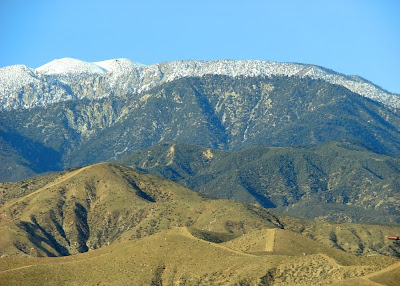
The Other California: Another Friday Fun Foto: A brief introduction to San Jacinto Peak, the highest mountain in the Peninsular Ranges, and one of the most prominent mountains in the state, with a 10,000 foot slope in one area.
A Mystery Photo for the Day: A view of a rock that looks like it belongs somewhere in the Sierra Nevada, but that is not where it is...
When is a Peninsular Range Not a Peninsula? Baja California is a peninsula, but the rocks continue into Alta California. This post explores the village of Idylwild next to the highest part of the province at San Jacinto Peak
I clearly have lots of ground to cover, and will update this page as necessary.
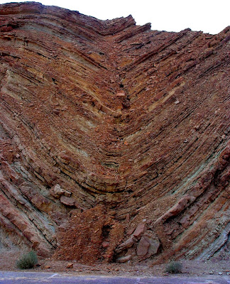
 Visitors at Calico Ghost Town in the Mojave Desert geomorphic province are treated to an authentic old mining town complete with bars, melodrama theatres, staged gunfights, and portraits in oldtime clothing. They may even learn a bit of genuine history of the old silver mining district from the occasional sign. Calico is California's Official Silver Rush Ghost Town (discussed in a previous post), and is definitely worth a stop, but not necessarily for the reason envisioned by those who run the park. The parking lot sits in the gulch below the town, and exposes some of the finest folds to be seen anywhere. They have appeared in many geology textbooks ("textbook examples" of anticlines, the upward pointing folds, and synclines, the downward pointing folds).
 The origin of these folds has been the subject of much discussion, but their proximity to an active transverse fault (the Calico fault) suggests they developed as a result of transpressional stress. Place a sheet of paper flat on a table, and put your palms on each end. Moving one hand towards you and the other away from you will cause crumpling across the middle. Those crumples are transpressional folds.
 In a marked contrast to the volcanic rocks that make up the core of the Calico Mountains, the Barstow layers are sedimentary rocks. Sedimentary structures such as mudcracks (below) and ripplemarks indicate that the sediments accumulated in a faulted basin in a moderately tropical and occasionally arid environment, essentially similar to the African Savannah of today's world. It was a world of grasslands and palm trees that existed between 13 and 19 million years ago, based on radiometric dates of volcanic ash layers that bracket the sedimentary strata.
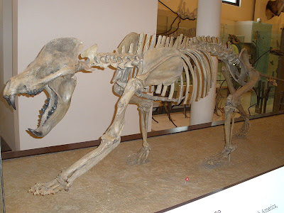
 An African savannah. Visions of elephants, giraffes, zebras, and rhinos. But not in America, right? Well, time for a new vision. The most stunning aspect of the Barstow Formation is the diversity of fossil species found in its layers. Numerous species of ancestral horses and camels, a rhino ancestor (Aphelops), and an early elephant called a gomphotherium (similar to those big elephants in the Lord of the Rings movie, only much smaller) are among the discoveries. Feeding on these planteaters were one of the earliest cats (Pseudaelurus), an ancestor to the coyotes (Tomarctus), and a probable forebear to the bears and dogs called an Amphicyon (pictured below).


