Showing posts with label Death Valley. Show all posts

Thursday, February 22, 2024

Echoes of a Watery Paradise in a Forsaken Hellscape - The Brief Return of Death Valley's Lake Manly

Imagine a lake that's six miles across flanked by dramatic mountain peaks reaching heights greater than 10,000 feet. We're in California, so it's got to be Lake Tahoe, right? But it's not. It is the lowest and driest place in North America, and the hottest place in the world. It's Death Valley. And big lakes are not a normal part of the scenery here. Badwater Basin is normally a dry salt flat. What has happened here?
In a word, it's rain. An extraordinary amount of rain has fallen in and around Death Valley this year, around 300% of what is normal. That sounds more dramatic than saying that 4.8 inches has occurred so far. A "normal" year to this point would see about 1.5 inches. And the rain did not fall in Death Valley alone. Death Valley is the lowest basin in a very large drainage system, and the surrounding landscape received even more. It was primarily the result of two events: the remnants of Hurricane Hilary in late August 2023 provided the floodwaters that resulted in the first iteration of the lake. In the hot months that followed, much of the accumulated water evaporated, but then the first week of February brought an atmospheric river storm to California that rejuvenated the shrinking lake. We were lucky to arrive a week later.

This kind of thing doesn't happen often. Some water was present on the valley floor in 2010, and earlier in 2005. But both of those years, floods had damaged the road to Dante's View so I haven't had a birds-eye view of the lake in at least three decades. It was fantastic.

When I and my students travel to Death Valley they get a packing list, but I tend not to put 'kayak' or 'raft' on that list. But we knew the lake would be there, so our long-term friend and trip volunteer Ryan actually packed one, so we had the spectacle of the Hollister family rafting Death Valley. 

The lake has been in the news, so we weren't surprised to see a multitude of tourists gathered in the parking lot at Badwater. I didn't think they'd all opt to go walking in the slimy muddy salty water, but you can see that they did. I was much happier to have stopped along the lake a mile to the south where there was no one but ourselves.

It was along that quiet shoreline that I was able to hear the echoes of a distant past when Death Valley was a watery paradise rather than the hellscape it is today (albeit a very beautiful and dramatic hellscape). That is what is revealed by the geological evidence scattered along the normally parched lake margins. 


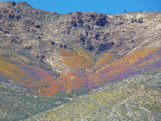
At the south end of Death Valley there is an old basalt cinder cone with a strange name: Shoreline Butte. In the picture above, the shoreline terraces are highlighted by the "Superbloom" of 2016 (with all the rain this year, there is at least a possibility of another superbloom in a few weeks). Each of those horizontal terraces was carved by wave action. This and other clues scattered around the margins of the basin are evidence of a lake that existed here for thousands of years. It was as much as 600 feet deep, and more than 100 miles long. 

Where did all that water come from?

Along Beatty Cutoff Road, there is a beach berm covered by rounded flattened pebbles. This was along the northern shoreline of Lake Manly when it was 450 feet deep.
Evidence suggests that Lake Manly existed during a period from 186,000–120,000 years before present, dried up, and then returned again between about 35,000 to 10,000 years ago. It can't be a coincidence that these dates are identical to the dates established for the Tahoe and Tioga stage glaciations that took place in the Sierra Nevada. No glacier ever reached Death Valley, but the Sierra glaciers contributed vast amounts of meltwater to the dry basins east of the mountains. These waters filled present-day Mono Lake to overflowing. It spilled over and flowed in the Owens River to Owens Lake, which actually persisted into the modern era when LA water diversions caused it to dry up in the 1920s.

Pluvial lakes of Eastern California. Source: Philip Stoffer of the U.S. Geological Survey

Ice-age Owens Lake reached a depth of 300 feet and spilled over into China Lake, then Searles Lake, Panamint Lake, and finally Lake Manly in Death Valley. These ice-age bodies of water are called pluvial lakes. The cooler wetter conditions allowed two other river systems to contribute water, the Amargosa River out of Nevada, and the Mojave River out of the San Bernardino Mountains in Southern California. There may have even been a temporary connection with the Colorado River, which resulted in one of the most surprising aspects of Death Valley biology: fish!

Salt Creek Pupfish from the middle of Death Valley

Yes, there are fish in Death Valley! In fact, there are several species. They survive in widely scattered springs and short stretches of perennial streams that exist in the desert. The pupfish (cyprinodon) are of particular interest because they probably once were a single widespread species, but when isolated in springs that were either hot or cold, or salty or fresh, they were forced to evolve or perish. Today there are four species in the confines of the park and several others in outlying areas, especially the Owens Valley and Ash Meadows in Nevada. I've found their story to be intriguing and I've written about them a number of times. These diminutive fish survive in the saltiest and hottest water of any known fish species.

Mammoth bones on display at the Shoshone Museum, east of Death Valley

Imagining this vast ice-age lake meant led to another vision of past worlds. In the early 1980s, some students on a geology field trip were hanging out near their camp in the Shoshone area when they discovered bones sticking out of a gully wall. These bones proved to be specimens of Columbian Mammoths and other ice age mammal species (the specimens are currently on display in the Shoshone Museum east of the park). The Death Valley region was a much cooler and more verdant environment during the ice ages, and the shoreline of Lake Manly was populated by grazing animals including the aforementioned mammoths, camels, horses, bison, and the carnivores that would have preyed upon them, including the large cats and perhaps relatives to today's wolves and coyotes.

Looking at the shore of Lake Manly at Badwater from a vertical mile above from Dante's View
To see a lake that only comes into existence every decade or so is a spectacle (in the best sense). But to understand the deeper implications suggested by these lakes that speak of past worlds is the magic of geology. See it if you can. It won't last much longer!

Friday, September 15, 2023

A California Love Letter: It's the Best Geology to be Found Anywhere!

This is the second of some resource materials I have on our college website that are being removed, so I wanted to preserve them. The following is some info I give to my students of my "Geology of California" course. For the majority of these students, it is their first introduction to geology, and their first introduction to the extraordinary state that is their home. For a more complete explanation of each superlative, click on the orange links (down the rabbit hole!). Enjoy!

Highest point in the lower 48 states: Mt. Whitney, 14,505 feet 

Lowest point in the western hemisphere: near Badwater, Death Valley, -282 feet

The deepest canyon in North America (maybe): Kings Canyon, Giant Sequoia National Monument. Hells Canyon on the Oregon/Idaho border may be 19 feet deeper. Maybe...

Largest living things in the world: Sequoia Trees

Tallest living things in the world: Coast Redwoods

Oldest living things in the world: Bristlecone Pines (5,000 years), White Mtns, or Creosote Bushes in Colorado Desert (11,000 years)

My Scottish BBC Interview at a relatively balmy 110 degrees

Hottest Place on the Planet and Driest Place in North America: Death Valley: 134 degrees, precipitation 1.4"/year

One of the Snowiest Places in the U.S.: Tamarack, Sierra Nevada, 76 feet in one year, 32 feet in one month, 37 feet on ground at one time

Highest Waterfall in the North America (no. 7 in world): Yosemite Falls, 2,425 feet

Second tallest active volcano in the U.S.: Mt. Shasta, 14,162 feet

Second most recently active volcano in lower 48 states: Mt. Lassen (1914-21)

Most voluminous volcano in the lower 48 states: Medicine Lake Highland (around 130 cubic miles) in northeastern California

Scarp from the 1872 Lone Pine earthquake

Some of the largest earthquakes in the lower 48 states: 1906 (San Francisco 7.8), 1872 Lone Pine (7.8), 1857 (Ft. Tejon 7.8)

Old oil derrick near the Santa Clarita Valley

One of the more prolific oil and natural gas producing regions in the world: Los Angeles Basin, Bakersfield, and Santa Barbara-Ventura Channel

One of the biggest explosions ever: Long Valley Caldera, 750,000 years ago, 125 cubic miles of ash spread all over the western states as far east as Nebraska and Kansas

McWay Falls at Julia Pfeiffer-Burns State Park on the Big Sur Coast

No other state has the combination of landscapes: Coastlines, deserts, mountains, river valleys and plateaus, due in no small part to the fact that California is influenced by all three different kinds of plate margins: Divergent, convergent and transform. Few places in the world have this kind of diversity.

The San Andreas fault on the San Francisco Peninsula. San Andreas reservoir, from which the fault took its name, is in the foreground.

What would you add to this list???

Sunday, March 8, 2020

The Islands of Interior California: There's a Reason I Don't Hug Ducks

There are islands in the interior of California. They aren't islands in the normal sense of the word, and are actually pretty much exactly the opposite. In the great California Desert, consisting of the Colorado (Sonoran; also the Lower) Desert, the somewhat higher Mojave Desert (the "High" Desert), and the Basin and Range, there are islands of water. And it is water, of course, that makes life possible in these harshest of climates.

Stovepipe Wells in Death Valley National Park is one of these islands. Tucked along the base of Tucki Mountain at the north end of the Panamint Range, Stovepipe Wells is a small resort complex consisting of a hotel/restaurant, bar, store, gas station, and campground. The resort is not actually at the location of the original Stovepipe Wells. That locality was located several miles to the northeast on the other side of the Mesquite Dunes.
Death Valley is the driest place in North America and the hottest place in the world. It is also the lowest region in North America, and this leads to some unexpected discrepant facts. There is actually lots of water in Death Valley. It doesn't come from the rainfall, but instead it comes from the ground. Water underground tends to flow downhill from higher elevations, and Death Valley is the lowest place there is, so springs flow in unexpected places. And even if there are no springs, the water may still be only a short distance beneath the surface.

That was the case for the Old Stovepipe Wells. At the edge of the sand dunes, there was a low spot where a bit of digging and scraping could cause fresh water to flow to the surface. The spot was utilized in ancient times apparently, but it was more developed in the mining days of the late 1800s. It was the only water source on the floor of Death Valley between Furnace Creek and the mining towns of Skidoo and Rhyolite. Dunes sometimes obscured the site, so it was marked with an old stovepipe, hence the name.

The water at Old Stovepipe Wells was of variable quality and could apparently be dangerous at times. According to one account, "...the water is very low in the spring, is of a yellowish appearance and intensely nauseating in taste. Its odor is very disagreeable, and it can be smelled for half a mile away." The man went on to describe getting very sick and nearly dying before reaching his destination fourteen miles away. One of the problems is that the water became stagnant quickly and that it was important to drain away the fetid water so that fresher water could flow into the hole. Although there were efforts to develop the site, it was clear that Old Stovepipe Wells was not going to become a permanent resort.

There is no information that I could uncover regarding natural flora and fauna around the original Stovepipe Wells. There no doubt was life of some kind, but none is recorded. During my stays at Stovepipe, I've wandered the dunes and found plenty of evidence of life in the early morning sun. Tracks of insects, reptiles and mammals cover the rippled sands. But for the most part the life remains hidden during the day, burrowing underground to escape the harsh surface conditions. It's a little trickier for birds, and they are not often seen in the dune environment. Despite decades of observations, birdwatchers have reported a mere fourteen species at Mesquite Dunes.

But the modern resort of Stovepipe Wells a mere two miles from the dunes? The total number is species reported there is 197! How in the world is such diversity possible? It's the water of course, but perhaps not in the way that you might think. Fresh water is now pumped from deep underground, providing plentiful clean water for the resort. They don't waste the water (aside from the swimming pool perhaps) having little in the way of landscaping (just a few tamarisk trees around the property). There are no open water sources for birds. For years I've camped at Stovepipe, and I've seen only Common Ravens and the invasive and ubiquitous House Sparrow that seems to follow humans wherever they go. I was intensely curious where all the other birds must be hiding, and this year it finally occurred to me.
One of the things they never tell novice birders like myself is about the absolute best place to see birds. It's not, as one would imagine, standing at the edge of a beautiful meadow with the forest and dramatic snowy peaks in the distance. And it isn't necessarily along the crashing surf near coastal estuaries. It's sewage treatment lagoons...really. Back home, the sewage treatment ponds at Modesto host 234 species. The nearby National Wildlife Refuge has fewer than 200.

Consider. A resort, even a modest one like Stovepipe, produces thousands of gallons of liquid waste and sewage every day, and by law the water must be treated. One of the best ways is to use settling ponds and bacteria that consume the worst of the waste material. The treated water can then be allowed to soak back into the ground where the sand and silt provide a natural filtering effect. The sewage lagoons have to have open ponds, and these are the "islands" that attract the multitudes of bird species that have been spotted here over the years. One can imagine that some birds memorize the localities and return during migrations, while other are desperately lost and find the settling lagoons entirely by lucky chance. Some species can be seen daily, while many others were one-time "accidents" and haven't been seen in decades.

Once I figured this out, I made sure to explore the vicinity of the sewage ponds at sunrise before most of my students were up and preparing for the day. For the record they did not smell terrible as one might think. But they finally provided me with some interesting bird species, including the Red-winged Blackbird (above), dozens of American Coots, a Blue-gray Gnatcatcher (below), the ever-present Common Ravens, a Say's Phoebe, a Great-tailed Grackle, and a Black-throated Sparrow, a species I never see back home in Modesto.
On the final morning of the trip, I saw the birds that inspired the title of today's post. There were four Cinnamon Teals in the pond. They are among my favorite ducks, given their unique coloration. But despite knowing that the water is not necessarily putrid, I still would not be thrilled with grabbing them close and hugging them. That's just asking for trouble in many ways...

Friday, February 21, 2020

The Islands of Interior California: A New Geotripper Series


I've always been fascinated by islands. I visit the Hawaiian Islands every chance I get, and I am literally haunted by the vast expanses of open ocean that separate the islands from any other landmasses. It's an odd combination of loneliness and wonder. It's not something you ever feel when you are staying in Waikiki hotels and sunning yourself on a crowded beach. The sense of isolation comes when you spend time in the rainforests, the alpine deserts, and the barren volcano slopes. When you read about and experience the incredible biological isolation, it becomes an incredible story of survival and adaptation that has produced hundreds of unique endemic species found nowhere else in the world.

Which leads to a question: what does that have to do with a bunch of pictures of localities in the California desert?

I was in Death Valley National Park for much of the past week, and while I was teaching a field course, I also had a few moments of observation and reflection about life in the desert. I was watching for bird species in particular, and I was struck by an odd contradiction: Death Valley (Furnace Creek specifically) has more bird species (339) than my county in California's Great Valley (315). It doesn't seem possible, since conditions are far more benign at home, and in fact the Great Valley can support vastly greater numbers of birds. But Death Valley has a way of forcing more species together in one place where they can be seen and recorded...it is a system of biological islands. The islands are made of water, and the intervening space is largely barren land.
The concept of biologic islands in a landscape is not a new concept at all, so I am not introducing any kind of new idea here. It's just that I sensed the concept more than usual during the recent trip. So in the next few posts I want to describe some of the unique and different "islands" that exist in the California desert, and the geological conditions that caused them. Some of these we explored last week, but as I considered the idea of a series, I thought of a few unique spots I've visited in earlier journeys, so I will include a few of them as well.
Coming up in the next post: the spot that made me think of islands in the first place...


Part 1: The Littlest Islands of All
Part 2: The Pygmy Mammoths and the Doomed Sky Islands
Part 3: There's a Reason Why I Don't Hug Ducks

Monday, January 27, 2020

To the Unprepared, it is the Place of Death; For Scholars of Earth History, it's a Wonderland. Join us, February 13-17, in Death Valley!

Re-posting from 1/10/20. Our organizational meeting is on Thursday, January 30, at 5:30 PM in Science Community Center Room 326 (the Geology Lab). If you can't make the meeting but wish to join the class, contact me.
Some lands are harsh and lie at the limits of human survival...visiting or inhabiting these lands without preparation would be deadly, and if you are dying of thirst or exposure, you're hardly going to care about the rugged beauty around you.

People have lived in this place in small numbers for at least 10,000 years. Four distinct cultures are known, including the Timbisha Shoshone who still live in the region. They were able to live and thrive within the limits imposed by this extreme desert environment. The first Europeans to arrive during the Gold Rush era were not prepared for the conditions, and it was they who conferred the present-day name of the park: Death Valley.

We are privileged to live in a time and place where technology allows us to visit these lands with our basic needs fulfilled, allowing us to appreciate the landscape and story behind the scenery. This is not to minimize the risks involved when the technology (or basic intelligence) fails us. Death Valley continues to be a dangerous place for the unprepared and people get into serious predicaments every year.
But what a place it is! Death Valley National Park is the largest park in the lower 48 states, and it preserves upwards of 2 billion years of earth history. The story in the rocks is more complete than any other park in the country, including even the Grand Canyon. The Paleozoic sediments alone are 20,000 feet thick, and the late Proterozoic rocks add 15,000 feet more. There are metamorphic rocks that are among the oldest in the American west, and volcanic rocks that are among the youngest (perhaps only a few hundred years).
The landscape is spectacular as well. The floor of Death Valley is the lowest and driest place in North America, and the hottest place in the world. Elevations range from -286 feet to more than 11,000 feet. There are times when one can stand in the broiling sun at Badwater and look at snowbanks on Telescope Peak. There are faults and badlands, alluvial fans and barren salt flats. There are hundreds of plant and animal species, including four species of fish (seriously).

Does this sound intriguing, a kind of place that you might like to visit? You could be there in a few weeks, and learn the details of the geologic story of this unique and precious place. I'll be teaching a 2-unit course on the geology Death Valley through Modesto Junior College on Feb. 13-17, 2020. We'll be camping out and spending our days hiking and exploring this fascinating place. If this all sounds interesting, join us! If you live in the Modesto area, we'll have an informational meeting on Thursday, January 30 at 5:30 PM in Science Community Center Room 326. If you can't make the meeting, all the trip information is available at the class website  at: http://hayesg.faculty.mjc.edu/Death_Valley_Field_Studies.html. Information on registration for classes at Modesto Junior College can be found at https://www.mjc.edu/.

Come and join us!

Friday, January 10, 2020

To the Unprepared, it is the Place of Death; For Scholars of Earth History, it's a Wonderland. Join us, February 13-17, in Death Valley!


Some lands are harsh and lie at the limits of human survival...visiting or inhabiting these lands without preparation would be deadly, and if you are dying of thirst or exposure, you're hardly going to care about the rugged beauty around you.

People have lived in this place in small numbers for at least 10,000 years. Four distinct cultures are known, including the Timbisha Shoshone who still live in the region. They were able to live and thrive within the limits imposed by this extreme desert environment. The first Europeans to arrive during the Gold Rush era were not prepared for the conditions, and it was they who conferred the present-day name of the park: Death Valley.

We are privileged to live in a time and place where technology allows us to visit these lands with our basic needs fulfilled, allowing us to appreciate the landscape and story behind the scenery. This is not to minimize the risks involved when the technology (or basic intelligence) fails us. Death Valley continues to be a dangerous place for the unprepared and people get into serious predicaments every year.
But what a place it is! Death Valley National Park is the largest park in the lower 48 states, and it preserves upwards of 2 billion years of earth history. The story in the rocks is more complete than any other park in the country, including even the Grand Canyon. The Paleozoic sediments alone are 20,000 feet thick, and the late Proterozoic rocks add 15,000 feet more. There are metamorphic rocks that are among the oldest in the American west, and volcanic rocks that are among the youngest (perhaps only a few hundred years).
The landscape is spectacular as well. The floor of Death Valley is the lowest and driest place in North America, and the hottest place in the world. Elevations range from -286 feet to more than 11,000 feet. There are times when one can stand in the broiling sun at Badwater and look at snowbanks on Telescope Peak. There are faults and badlands, alluvial fans and barren salt flats. There are hundreds of plant and animal species, including four species of fish (seriously).

Does this sound intriguing, a kind of place that you might like to visit? You could be there in a few weeks, and learn the details of the geologic story of this unique and precious place. I'll be teaching a 2-unit course on the geology Death Valley through Modesto Junior College on Feb. 13-17, 2020. We'll be camping out and spending our days hiking and exploring this fascinating place. If this all sounds interesting, join us! If you live in the Modesto area, we'll have an informational meeting on Thursday, January 30 at 5:30 PM in Science Community Center Room 326. If you can't make the meeting, all the trip information is available at the class website  at: http://hayesg.faculty.mjc.edu/Death_Valley_Field_Studies.html. Information on registration for classes at Modesto Junior College can be found at https://www.mjc.edu/.

Come and join us!

Tuesday, December 31, 2019

A Resolution Recommendation: See the World. See as Much of the World as You Can

Grapevine Mountains in Death Valley National Park
When I first began to think about what I wanted to do with my life sometime in my teens, I knew I wanted a job that would take me outdoors for much of the time. When I was in high school, "earth science" or "geology" didn't exist as a course choice. So far as I knew, the "outdoor" major was to be a wildlife biologist, and I started heading that way. But in my first semester at community college, all the classes were full, so I took some course called "earth materials". The next semester I took "earth history", and a field course to the Grand Canyon. And by then I was hooked. I wanted to teach geology (many thanks to my first teachers, Marlin Dickey and Rod Parcel).
Death Valley National Park
My journey to a degree in geology was not an easy one. I did okay in my community college courses, achieving a pretty good GPA, enough to get me into a quality program at Pomona College, where I found the limitations of lazy study skills. I spent three years getting my act together, and another two working for the department before I started the graduate program at the University of Nevada, Reno. Once again I was challenged to the limits of my abilities, especially with a young family to support. But I made it through, holding a crying baby at two in the morning while typing my thesis on a Commodore 64 computer with a daisy wheel printer.
The Trona Pinnacles in the California Desert at Searles Lake
Somehow, I made the cut for a position as a laboratory teaching assistant, and later adjunct faculty at Santa Barbara City College. I worked there for four wonderful years before I was fortunate enough to be chosen as an instructor of geology at Modesto Junior College, where I've been teaching for 31 years and counting.
The 2019 "Super-bloom" in the Mojave Desert of California
Geology provided my one of the greatest gifts of my life. A doctor explores the human body. A computer programmer explores the circuitry of processors. A chemical engineer explores atoms and compounds. But a geologist explores the earth. And I can't imagine a greater privilege. The greater privilege though has been that I have spent a third of a century introducing students to a world outside the confines of their home cities. There is nothing quite like seeing the response of a student seeing the Grand Canyon or Yosemite Valley for the first time in their life.
Mesquite Dunes in Death Valley National Park
Our world, despite our horrible abuses, is a wonderous place, still full of beauty and adventures. Seeing it is a marvelous journey, but having some understanding of how it came to be gives the adventure deeper meaning. Even the plainest of landscapes, say the Central Valley (to us the Great Valley) has a fascinating story, one filled with oceans full of mosasaurs and plesiosaurs, gigantic sharks, and savannas full of mammoths, giant sloths and sabertooth cats.
A Five-spot in Death Valley National Park
Not everyone can travel and explore the planet, for lots and lots of reasons. When digital cameras became widespread, and this thing called the blogosphere appeared some time back in the cyber-early Pleistocene, I finally realized I had another tool with which to share the world. In 2008 I started this blog, with the idea of posting lots of pictures of the beautiful places of the planet. It became a way of introducing the wonders of the planet with people far beyond the confines of my college. I never dreamed I would still be doing it twelve years (and more than 2,100 posts) later. I have always appreciated those who have read and responded over the years.
Yosemite Falls, the 5th or 7th highest waterfall in the world.
In any case, this post is sort of a year-end gift of images from the journeys this year of myself, Mrs. Geotripper, and my wonderful students. If you live in California, a lot of these places are within a day's drive. I took students to Death Valley National Park in February, and Mrs. Geotripper and I made another trip there in March to seek out flowers.
"Mirror" Lake, a seasonal pond on Tenaya Creek in Yosemite Valley. Mt. Washburn in the distance.
Yosemite is close enough to Modesto for a day trip, and I managed to get there on four different occasions this year, mainly in the fall and in the spring. It's a different place with every visit, with new discoveries to be made every time.
The Gateway in Yosemite Valley, with El Capitan on the left and the Cathedral Rocks on the right.
We had the occasion of my grandmother's 100th birthday as a reason to spend a few days camping in the Coast Redwoods of Northern California
Humboldt Redwoods State Park in Northern California
Our summer field studies class gave us the chance to explore the Pacific Northwest and British Columbia. Use the search engine at the top left to check out "Travels in Cascadia" for the detailed stories of the places in the pictures that follow.
Mt. Shasta, the largest (but only second highest) stratovolcano in the lower 48 states.

Cape Flattery, the northwesternmost point of the lower 48 states, near Neah Bay, Washington

The Olympic Mountains from Hurricane Ridge in Olympic National Park

Lupines in Hurricane Ridge in Olympic National Park, Washington

The upper end of Howe Sound, the southernmost glacial fjord on the west coast of North America, British Columbia from near the summit of Stawamus Chief near Squamish

Black Bear in Whistler, British Columbia in Canada

Rainy Lake near North Cascades National Park in Washington

North Cascades National Park in Washington
In September, we carried on an exploration of the eastern Sierra Nevada, traveling over Sonora Pass. We base-camped in Bishop for three days while we explored the High Sierra near Mammoth and June Lake, Mono Lake, and the White Mountains.
Sunrise out of Bishop, California, east of the Sierra Nevada
The White Mountains are an immense range reaching more than 14,000 feet, and containing one of the most unusual forests on the planet: the Bristlecone Pines. The trees live where almost nothing else can thrive, and they live for incredible lengths of time, as much as 5,000 years. From the Bristlecone Forest, one can take in more than a hundred miles of the Sierra Nevada crest, from Mt. Whitney to the Mammoth Lakes area.
The Sierra Nevada crest as seen from the White Mountains
The eastern Sierra Nevada is also a land of volcanism. We explored Devils Postpile, the Long Valley Caldera, the Bishop Tuff, and other features of recent volcanic activity.
Devils Postpile in the central Sierra Nevada
The Sierra Nevada is also one of the finest places in the world to study the effects of the Pleistocene glaciations. The June Lake Loop is an awesome valley that also serves as a gateway to the higher alpine parts of the Sierra.
Silver Lake on the June Lake Loop of the Eastern Sierra Nevada
Mono Lake is an enclosed basin filled by a saline inland sea. It is one of the most important stops on the migratory bird flyway, and the story of its preservation from the schemes of the LA Department of Water and Power is a rare (but still ongoing) environmental victory.
Mono Lake, near Lee Vining, California, east of the Sierra Nevada
Our journey home took us over Tioga Pass and through the high country of Yosemite National Park including Tuolumne Meadows and Tenaya Lake.
Tenaya Lake in Yosemite National Park
Our journeys weren't always on the surface. An October field studies class took us underground at Black Chasm Caves in the Sierra Nevada Mother Lode. There are more than a thousand limestone and marble caverns in California!
Black Chasm Cavern near Jackson, California in the Sierra Nevada Mother Lode
Our last journey of the year took us north to visit family in Oregon and Washington. The weather was not optimal, but I had a brief view of Mt. Rainier from the shores of Lake Washington one morning. The mountain looms over the Pacific Northwest in more than one way. The volcano is close enough to threaten urban areas on the Puget Sound.
Mt. Rainier from Lake Washington, near Seattle.
But in the end, don't forget about the most important place of all: home. There is a bit of nature hanging on anywhere you might live, even in the midst of the biggest cities on Earth. Find that place you can get to without too much trouble and expense, and get to know it well, maybe know it better than anyone else. Learn the birds, the mammals, the bugs, the reptiles. Get to know the rocks and plants. Watch them change over the course of the year. Your life will be richer for it.
The Tuolumne River in Waterford California, my home place
I wish for you the most wonderful of new years and new beginnings, even with the challenges that face us all. Thanks for reading!
The Tuolumne River in Waterford, California.