Showing posts with label Olympic National Park. Show all posts

Tuesday, December 31, 2019

A Resolution Recommendation: See the World. See as Much of the World as You Can

Grapevine Mountains in Death Valley National Park
When I first began to think about what I wanted to do with my life sometime in my teens, I knew I wanted a job that would take me outdoors for much of the time. When I was in high school, "earth science" or "geology" didn't exist as a course choice. So far as I knew, the "outdoor" major was to be a wildlife biologist, and I started heading that way. But in my first semester at community college, all the classes were full, so I took some course called "earth materials". The next semester I took "earth history", and a field course to the Grand Canyon. And by then I was hooked. I wanted to teach geology (many thanks to my first teachers, Marlin Dickey and Rod Parcel).
Death Valley National Park
My journey to a degree in geology was not an easy one. I did okay in my community college courses, achieving a pretty good GPA, enough to get me into a quality program at Pomona College, where I found the limitations of lazy study skills. I spent three years getting my act together, and another two working for the department before I started the graduate program at the University of Nevada, Reno. Once again I was challenged to the limits of my abilities, especially with a young family to support. But I made it through, holding a crying baby at two in the morning while typing my thesis on a Commodore 64 computer with a daisy wheel printer.
The Trona Pinnacles in the California Desert at Searles Lake
Somehow, I made the cut for a position as a laboratory teaching assistant, and later adjunct faculty at Santa Barbara City College. I worked there for four wonderful years before I was fortunate enough to be chosen as an instructor of geology at Modesto Junior College, where I've been teaching for 31 years and counting.
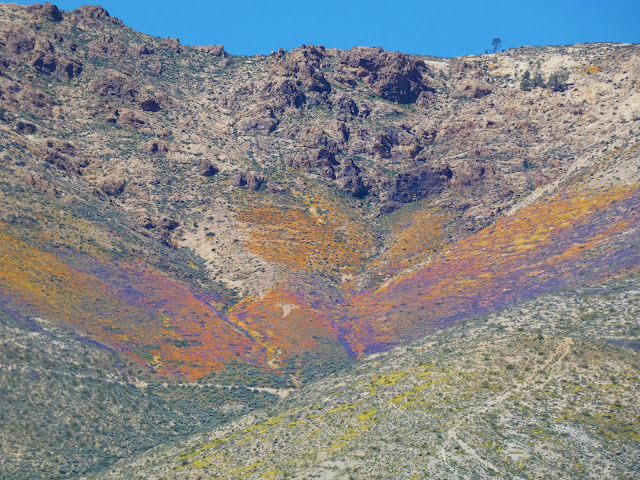
The 2019 "Super-bloom" in the Mojave Desert of California
Geology provided my one of the greatest gifts of my life. A doctor explores the human body. A computer programmer explores the circuitry of processors. A chemical engineer explores atoms and compounds. But a geologist explores the earth. And I can't imagine a greater privilege. The greater privilege though has been that I have spent a third of a century introducing students to a world outside the confines of their home cities. There is nothing quite like seeing the response of a student seeing the Grand Canyon or Yosemite Valley for the first time in their life.
Mesquite Dunes in Death Valley National Park
Our world, despite our horrible abuses, is a wonderous place, still full of beauty and adventures. Seeing it is a marvelous journey, but having some understanding of how it came to be gives the adventure deeper meaning. Even the plainest of landscapes, say the Central Valley (to us the Great Valley) has a fascinating story, one filled with oceans full of mosasaurs and plesiosaurs, gigantic sharks, and savannas full of mammoths, giant sloths and sabertooth cats.
A Five-spot in Death Valley National Park
Not everyone can travel and explore the planet, for lots and lots of reasons. When digital cameras became widespread, and this thing called the blogosphere appeared some time back in the cyber-early Pleistocene, I finally realized I had another tool with which to share the world. In 2008 I started this blog, with the idea of posting lots of pictures of the beautiful places of the planet. It became a way of introducing the wonders of the planet with people far beyond the confines of my college. I never dreamed I would still be doing it twelve years (and more than 2,100 posts) later. I have always appreciated those who have read and responded over the years.
Yosemite Falls, the 5th or 7th highest waterfall in the world.
In any case, this post is sort of a year-end gift of images from the journeys this year of myself, Mrs. Geotripper, and my wonderful students. If you live in California, a lot of these places are within a day's drive. I took students to Death Valley National Park in February, and Mrs. Geotripper and I made another trip there in March to seek out flowers.
"Mirror" Lake, a seasonal pond on Tenaya Creek in Yosemite Valley. Mt. Washburn in the distance.
Yosemite is close enough to Modesto for a day trip, and I managed to get there on four different occasions this year, mainly in the fall and in the spring. It's a different place with every visit, with new discoveries to be made every time.
The Gateway in Yosemite Valley, with El Capitan on the left and the Cathedral Rocks on the right.
We had the occasion of my grandmother's 100th birthday as a reason to spend a few days camping in the Coast Redwoods of Northern California
Humboldt Redwoods State Park in Northern California
Our summer field studies class gave us the chance to explore the Pacific Northwest and British Columbia. Use the search engine at the top left to check out "Travels in Cascadia" for the detailed stories of the places in the pictures that follow.
Mt. Shasta, the largest (but only second highest) stratovolcano in the lower 48 states.

Cape Flattery, the northwesternmost point of the lower 48 states, near Neah Bay, Washington

The Olympic Mountains from Hurricane Ridge in Olympic National Park

Lupines in Hurricane Ridge in Olympic National Park, Washington

The upper end of Howe Sound, the southernmost glacial fjord on the west coast of North America, British Columbia from near the summit of Stawamus Chief near Squamish

Black Bear in Whistler, British Columbia in Canada

Rainy Lake near North Cascades National Park in Washington

North Cascades National Park in Washington
In September, we carried on an exploration of the eastern Sierra Nevada, traveling over Sonora Pass. We base-camped in Bishop for three days while we explored the High Sierra near Mammoth and June Lake, Mono Lake, and the White Mountains.
Sunrise out of Bishop, California, east of the Sierra Nevada
The White Mountains are an immense range reaching more than 14,000 feet, and containing one of the most unusual forests on the planet: the Bristlecone Pines. The trees live where almost nothing else can thrive, and they live for incredible lengths of time, as much as 5,000 years. From the Bristlecone Forest, one can take in more than a hundred miles of the Sierra Nevada crest, from Mt. Whitney to the Mammoth Lakes area.
The Sierra Nevada crest as seen from the White Mountains
The eastern Sierra Nevada is also a land of volcanism. We explored Devils Postpile, the Long Valley Caldera, the Bishop Tuff, and other features of recent volcanic activity.
Devils Postpile in the central Sierra Nevada
The Sierra Nevada is also one of the finest places in the world to study the effects of the Pleistocene glaciations. The June Lake Loop is an awesome valley that also serves as a gateway to the higher alpine parts of the Sierra.
Silver Lake on the June Lake Loop of the Eastern Sierra Nevada
Mono Lake is an enclosed basin filled by a saline inland sea. It is one of the most important stops on the migratory bird flyway, and the story of its preservation from the schemes of the LA Department of Water and Power is a rare (but still ongoing) environmental victory.
Mono Lake, near Lee Vining, California, east of the Sierra Nevada
Our journey home took us over Tioga Pass and through the high country of Yosemite National Park including Tuolumne Meadows and Tenaya Lake.
Tenaya Lake in Yosemite National Park
Our journeys weren't always on the surface. An October field studies class took us underground at Black Chasm Caves in the Sierra Nevada Mother Lode. There are more than a thousand limestone and marble caverns in California!
Black Chasm Cavern near Jackson, California in the Sierra Nevada Mother Lode
Our last journey of the year took us north to visit family in Oregon and Washington. The weather was not optimal, but I had a brief view of Mt. Rainier from the shores of Lake Washington one morning. The mountain looms over the Pacific Northwest in more than one way. The volcano is close enough to threaten urban areas on the Puget Sound.
Mt. Rainier from Lake Washington, near Seattle.
But in the end, don't forget about the most important place of all: home. There is a bit of nature hanging on anywhere you might live, even in the midst of the biggest cities on Earth. Find that place you can get to without too much trouble and expense, and get to know it well, maybe know it better than anyone else. Learn the birds, the mammals, the bugs, the reptiles. Get to know the rocks and plants. Watch them change over the course of the year. Your life will be richer for it.
The Tuolumne River in Waterford California, my home place
I wish for you the most wonderful of new years and new beginnings, even with the challenges that face us all. Thanks for reading!
The Tuolumne River in Waterford, California.

Thursday, August 8, 2019

Travels in Cascadia: Threading the Needle on Hurricane Ridge

Leading a field studies trip is a stress-filled enterprise. There are the big things to worry about: auto accidents, injuries, conflicts with law enforcement, lost reservations, and those sorts of things. But those thankfully don't happen much. But weather does happen, and field studies trips tend to be tightly scripted affairs with not much room for weather-related complications. Yet they happen, especially on trips in the Pacific Northwest. We've had trips where we had just the one chance to see Mt. St. Helens, and it was completely fogged in. There was the one chance to see the Sea to Sky Highway in British Columbia, and it was raining the entire way. We've missed a lot.

This year was going to be different. We worked some flexibility into the schedule, spending two nights each at most of our localities, giving us the chance to postpone a particular plan for a day to allow the weather to clear up. But on our second day out, I was worried. Ever since the longest ten-day forecast, a storm was brewing out in the Pacific Ocean, one that was arriving in waves over several days. We had given ourselves two days on the Olympic Peninsula, and rain was falling on Hurricane Ridge the first day, so we elected to go to Neah Bay and Cape Flattery instead. But that left us just one more chance to have a clear view at Hurricane Ridge in Olympic National Park. The sunrise (above) was not promising. According to the forecast, we would have a brief window of maybe three or four hours before the storm closed in, but we drove through light showers on the road up to the ridge.
My concern grew as we continued up the road, rising from sea level to over 5,000 feet. The far ridges would appear for a moment and then become obscured, and I didn't know until we reached the top ridge if we would actually see anything...

… but we did! And no matter how many times I've been on Hurricane Ridge, nothing quite prepares me for the view from the end of the paved road. It is simply astonishing. As we emerged from the vehicles I felt the stress falling away, like dropping a particularly heavy load from my shoulders. We gathered the group and said a few words about the geology. We would save the longer presentations for later in the day down the hill. With an impending storm, I didn't want our students to miss any of the dramatic scenery. And it is dramatic.

The Olympic Mountains rise from sea level to nearly 8,000 feet and are extremely rugged. They capture prodigious amounts of rain and snow on the western flanks, so much so that temperate rainforests coat the western slopes. It was a nightmare for geologists who were trying to unravel the geologic history.

The mountains exist because of subduction. For most of 200 million years a convergent boundary has been active in the region, as the crust of the Pacific Ocean basin has been sinking against the edge of the North American Continent. In some places, like California, the subduction zone has been replaced by a transform boundary (the San Andreas fault). But in Northern California, Oregon, Washington, and part of British Columbia, the subduction zone is still active, still producing earthquakes, and still raising mountains. It's called the Cascadia Subduction Zone (from hence comes the name of this series).
Source: Geological Society of America

In a "normal" subduction zone, there are four parts: the trench, an accretionary wedge, a forearc basin, and a magmatic arc. The trench is the deepest part of the ocean floor where the oceanic crust sinks back into the mantle. The accretionary wedge is a collection of seafloor sediments and crust that has been scraped off the subducting plate and added to the edge of the continent. The forearc basin is a shallow sea that may develop inland of the accretionary wedge (California's Great Valley originated in this fashion). The magmatic arc is a system of volcanoes and intrusive plutons resulting from the melting of rocks in the lower crust and upper mantle above the descending slab (water released from the slab lowers the melting point of the rock, leading to the formation of the molten rock).


Looking at the thickly forested slopes below Hurricane Ridge, I cannot envy the geologists who originally mapped the Olympic Mountains. Simply finding an exposure of rock must have been challenging at times. What these geologists did was to take the rare rock exposures and extrapolate them into a semi-coherent map that reveals the structure of the Olympic Mountains. They did the equivalent of taking a few pieces of a jigsaw puzzle, putting them in the right location relative to the others, and then drawing in the remainder of the puzzle from scratch. I've been way too spoiled by the naked rock exposures of places like Death Valley and the Mojave Desert!

The geologic map reveals the basic structure of the Olympics. A "horseshoe" of basalt and sedimentary rocks (the Peripheral Rocks, or Crescent Formation) partially surrounds the "Core Rocks", an assemblage of lightly metamorphosed sandstone and shale layers. The Core Rocks are characteristic of the types of deposits that form from underwater landslides ("turbidity currents") within the trench and accretionary wedge of a subduction zone. The fact that these rocks are now thousands of feet above sea level is the interesting conundrum. Accretionary wedges are generally below sea level, or exist as small islands. They can be pushed higher. For instance, the rocks of the Cascadia accretionary wedge are exposed in the Coast Ranges of  Washington, Oregon and California, but nowhere are the exposures as spectacular as the Olympic Mountains.


Convergent boundaries can be exceedingly complex places. Bits and pieces of continents and island arcs may randomly arrive at the subduction zone, mucking up the subduction process the way too many sheets of paper at once can muck up a paper-shredder. In the case of the Olympics, there was a mass of land north (Vancouver Island) and an accreted terrane to the south (the North Cascades), and a bend in the subduction zone itself. In essence, too much material was being stuffed into the subduction zone, so the excess material went the only way it could, which was up. The mountains have been rising for around 15 million years. They would be higher, but the incredible amount of precipitation tears the mountains down at a roughly equivalent rate.

Pillow basalt from the subducted oceanic crust is exposed along the Hurricane Ridge Road and along trails near the viewpoint. When we went down the road later on, we found that a small rockfall had dumped some of the pillows onto our highway. So, as it turned out, we managed to miss having rocks fall on our vans, i.e., one of the hazards I mentioned at the start of the post!

We could easily observe the glaciers that scour the upper reaches of the mountains. Glaciers technically shouldn't exist here. Although we were at a high enough latitude, the nearby Pacific Ocean moderates the climate, keeping things warmer than they would otherwise be (the Olympics are at the same latitude as Great Falls, Montana, or St. Paul, Minnesota). But temperature isn't the only factor in glacier development. The sheer amount of snowfall in combination with temperatures that are just cold enough allows glaciers to exist at these unusually low elevations.
We had a good introduction to the basic features of alpine glaciation as we gazed across the valley to Mt. Olympus. There were horns, aretes, and cirques as well. Glaciers were going to be a big part of the story of British Columbia, and Hurricane Ridge provided a spectacular setting for the first discussion of how they worked.
It was nearly noon and the storm clouds were building. We were rained on as we descended back down to the lowlands. It was time to prepare for the ferry ride across the Strait of Juan de Fuca to Vancouver Island.

Thursday, May 9, 2019

There is Still Time to Join the Geotrippers (but not much)! British Columbia, the Channeled Scablands, the Olympic Peninsula and the North Cascades, June 26-July 10, 2019


What are you going to do this summer? Are there places in the world that you've thought of visiting but never made a plan? Maybe we can be of assistance in fulfilling your dreams! The geology and anthropology departments at Modesto Junior College will be conducting a field course dyad that will explore Washington and British Columbia on June 26-July 10, 2019. Anyone with an interest in geology or anthropology is encouraged to join us (if you want to skip the reading and get to the details, scroll down to the bottom of this post).

Our journey will begin in the Seattle area where we'll get our rental vans (yes, you'll need to find your way to Seattle). We'll then head out to the Olympic Peninsula where we'll explore Olympic National Park (including the iconic view from Hurricane Ridge, above). There will be an opportunity to explore some of the rainforest. Cape Flattery and the Makah Nation will be the anthropology focus on one day.

We'll then take the ferry across the Strait of Georgia to the city of Victoria on Vancouver Island. "Island" barely describes a landmass three hundred miles long. It has been inhabited by humans for thousands of years, and we'll be looking for petroglyphs and other archaeological evidence as we explore the south shore and then work our way north through Duncan to Nanaimo.

From Nanaimo, we'll take a ferry back to the North America mainland at Howe Sound. We will spend several days in the Vancouver area, exploring both the coastal mountains and Fraser River delta, and also the extensive museums in the city.

We'll travel the Sea to the Sky Highway, a spectacular route that leads from Vancouver to Whistler and Pemberton, site of the 2010 Winter Olympics. We'll have a chance to observe active glaciers and potentially active volcanoes, including Mt. Garibaldi and the Black Tusk.
You'll have a chance to figure out how this landscape happened...(below).
 We'll return to the United States by way of the Okanogan Valley and we'll then explore one of the strangest landscapes on Earth, the Grand Coulees and Channeled Scablands. The discovery of evidence for the incredible Spokane Floods of the ice ages is one of the great stories of geology.
We'll wrap up the trip by passing over the Cascade Range at North Cascades National Park with a stop along the potentially active Mt. Baker volcano.

This trip is just the latest of MJC’s unique collaboration of field studies in geology and anthropology, taught by anthropology professor Susan Kerr and geology professor Garry Hayes.

When and How? The group will come together in Renton, Washington (near SeaTac Airport and Seattle) on June 26 and will return to SeaTac mid-day on July 10. We will travel in rental vans, and stay in hotels.

Costs: The trip will cost $1,600, which includes transportation, admission fees, accommodations, and teaching materials. Students will be responsible for getting to and from Seattle, and for meals (many of the hotels offer free breakfasts, and some rooms will have microwaves). There will be the tuition costs for six units of semester credit, and the fees for getting or renewing a passport.

Accommodations: We are staying in a variety of motels and hotels. We are assuming double occupancy for married couples, and double to triple occupancy for singles. We will try to accommodate requests for single rooms for a surcharge, but cannot guarantee it. (The earlier your request, the better the chance for getting extra rooms).

Academics: The field courses are worth three semester units each (total of six). Participants will be expected to keep field notes and to complete worksheets and quizzes during the trip.

Contact the professors for more information (hayesg - at - Yosemite.edu or kerrs - at -Yosemite.edu). 

For up-to-date announcements, check out the trip Facebook page at https://www.facebook.com/groups/1920712791360611/ and the MJC Geology information page at http://hayesg.faculty.mjc.edu/GeologyPacificNorthwest.html