Sunday, November 30, 2014

Lenticular Clouds and Cascades Volcanoes (no UFOs today...)

We have Mrs. Geotripper to thank for today's picture. We've been on the road in Oregon and as we came over the hill into Medford at sunset, we were greeted with the extraordinary sight of a lenticular cloud settling over Mt. McLoughlin in the southern Cascades Range. I have to give Mrs. Geotripper some credit for managing several nice shots through the windshield of a car speeding along Interstate 5.

Mt. McLoughlin is 9,495 feet (2894 meters) in elevation and can best be described as a composite cone, as it is in part a basaltic shield with a prominent summit cinder cone and andesite flows. It has not erupted in the last 25,000 years and thus appears to be low on the list of recognized hazardous volcanoes. On clear days from some angles McLoughlin is a deceptively symmetrical cone. The summit has been deeply carved by glaciation.

Lenticular clouds will form when moist air is pushed over obstructions (such as, say, volcanoes) and the temperature reaches the dew point, forcing the water vapor to condense into clouds. As the air stream drops on the leeward side, the water droplets in the cloud evaporate again, forming the lens-like shape. The clouds have such a distinctive and unusual shape that they are seen as unnatural features (i.e. UFOs).

Friday, November 28, 2014

Autumn, Western Style

Sycamore at the Pinnacles National Park Visitor Center
I can't help but notice that winter has set in around much of the country, but my calendar says it's still autumn for another few weeks. I don't know why so many of you are so anxious to jump right into winter, but I'm not. As I've traveled around these last two weeks, I've seen some beautiful sights that I'm sharing as part of a feeling of thanksgiving.
Sycamore tree and Saguaro Cactus in Burro Canyon, Arizona
The western United States has some of the best geology to be found anywhere in the world, but the eastern U.S. can certainly boast a wonderful show when autumn rolls around. I'd never say we can compete for color, because our trees are usually few and far between, or hidden in conifer forests. Still there is great beauty in individual trees, like the Sycamore I saw last week at Burro Canyon in Arizona, or two weeks ago at Pinnacles National Park.
A street in Modesto CA
My home base of Modesto is no slouch in the color department. We may be the officially the #2 or #3 worst place to live, but for a few weeks in November, our streets come alive with color. One of our most colorful ornamentals is the Modesto Ash, a tree of western origin that is good in drought conditions.
In the Klamath Mountains near Dunsmuir

The mountains aren't done yet, either. As we drove north towards Oregon yesterday, the hills around Dunsmuir and Mt. Shasta were alive with color as well.

Our winter will come soon enough. I'm glad to see fall colors lasting for weeks after the leaves have all fallen elsewhere!

A Mildly Promising View of Mt. Shasta...It Has Snow!

Shasta from the vicinity of Dunsmuir from the south
A short note from the highway tonight. We were on a long road trip into central Oregon today and followed Interstate 5 through northern California. One of the real treats of following I-5 is the chance to see Mt. Shasta from many different directions.

Mt. Shasta has to be one of the most dramatic volcanic sights in the world. Rising to an elevation of 14,179 feet (4,322 m), it is the second highest volcano in the Cascades, and the most voluminous. It rises some 10,000 feet above its surroundings and can be seen from as much as a hundred miles away. It is the second most active Cascades volcano after Mt. St. Helens, with the most recent eruption in 1786.
Shasta from Mt. Shasta City to the west
What was most wonderful about the view today is that there was actually snow on the mountain. Compare the appearance today with that of last Christmas, and one can see the slightest glimmer of hope about California's drought, as the snowpack is building early. There is a major storm coming through the area right now, and it's expected to last for several days.

We need precipitation in California, and not just normal amounts. We've suffered through three years of intensive drought, and even a wet year will not dig us out of the water deficit that has been building. We've replaced some of the irrigation supplies by some serious overdrafting of our groundwater resources, and the reservoirs are, for all intents and purposes, empty.
Shasta from the vicinity of Yreka to the north

Wednesday, November 26, 2014

Happy Thanksgiving and Safe Travels (with a last look at our newest national park)

Here's hoping that you all have a fine Thanksgiving holiday and that your travels are safe and fun. I offer up one of the things that I am truly thankful for: politicians that put aside their differences and agreed to establish Pinnacles National Park in 2013. I've been posting lately about the fascinating geology of the park, and I'm taking a moment to point out one of the other values of this particular park: a sanctuary for wildlife.

Pinnacles has been one of the most dependable localities for seeing Wild Turkeys (which are not exactly a native species, but they have become naturalized in this region). 
On our last trip we saw the antics of the Acorn Woodpeckers around the Bear Gulch area...

And were watched carefully by a Raven at Bear Gulch Reservoir...
Pinnacles is a treasure. If you ever have a chance to explore central California, be sure to add it to your itinerary! In the meantime, have a safe and happy time wherever you may be. I'll be on the road, so posts may be scarce.

Tuesday, November 25, 2014

Fog Returns to the Great Valley! I hate it, but it's a good thing (tentatively)

Buffalo has apocalyptic lake-effect snow, Minnesota has blizzards, Phoenix has horrific dust storms, Kansas has tornadoes, New Orleans has hurricanes. In the big picture, those of us who live in the Great Valley of California don't have much in the way of weather issues. I have yet this year to put on a jacket in the morning, and I only stopped wearing shorts a few weeks ago because I wore a hole in the pocket. It gets hot in the summer, but only occasionally drops below freezing. We've had two "snowstorms" in 25 years. No wonder so many arctic birds like to winter here.

But we have one issue. When the first rains fall in October or November, the Tule Fogs come. These are thick radiation fogs generated during cold periods when moist ground cools off during the night. The water vapor condenses to water droplets in a dense blanket at ground level. The fog makes life not just miserable, but downright dangerous for drivers. What is it like? Get on a freeway sometime, and imagine driving with your eyes closed. And then imagine that everyone else has their eyes closed too, and that some of them are in a hurry. Some people just don't know enough to slow down and horrible chain reaction accidents result.

The fog sieges can last for weeks. I can remember hungering for sunlight so much that we would drive into the mountains for a few hours of respite from the gloom. The fog sets up under an inversion layer only a few tens or hundreds of feet thick, meaning the sun is shining just a few feet over our heads on the cloud tops, but not on us.

But we've not had many of these weeks-long sieges of late. With the intense drought that is crippling our state, the ground has been dry with no fog forming. Even with the wet years, the long term trend is for fewer foggy days, a decrease of 46% over the last three decades. The cause is in part related to global warming. With warmer average temperatures, the fog doesn't form as often, and with increasingly persistent droughts, the ground is not wet as often.
As I said in the title, I detest the fog, and I am glad any morning when I don't have to deal with a foggy morning commute. But the Tule Fog is important.  The fruit and nut trees that cover our four-hundred-mile long valley require cold temperatures for a few weeks to properly set, and long warm fog-free days don't allow this to happen as frequently. When one considers that the Great Valley provides most of the fruits, nuts, and vegetables grown in the United States, this is a serious issue, and it seems to be rarely discussed among farmers and politicians who "represent" the region. The pols (and some of the farmers) are too busy denying the reality of global warming to recognize that the consequences of warming are already affecting their profit margins.
The fact that the fogs are happening is also to realize that the ground is wet! We've had around two inches of precipitation so far this season. That's almost normal. The storms have been weak ones in our area, with only 0.20 inches in the last three storms, but they have kept coming and a more serious storm is on tap for the holiday weekend. They haven't been enough to put a dent in the drought, but they are an improvement over last year when we didn't reach the 2 inch mark until January. Since droughts may become the new "normal", we'll have to revel in the wet years when they come. We really need a wet year right now after three crippling dry years.

I hate the fog, but I'll tolerate it if it means the drought is ending.

Saturday, November 22, 2014

Caves in the Coast Ranges? Really? And a National Park? A Peek at Pinnacles

Bear Gulch Cave at Pinnacles National Park
California's Coast Ranges hide some real gems (literally: check out benitoite, for instance). One of my favorites is also the nation's newest national park: Pinnacles National Park. The park was first established as a national monument by Teddy Roosevelt in 1908, and given national park status in 2013.

The park preserves the spire-like remains of a rhyolitic stratovolcano that erupted around 23 million years ago. Long after the monument was established, geologists discovered an additional reason the region deserved park status: half of the volcano is in Southern California, 195 miles away! It turns out the volcano erupted on the San Andreas fault, and has been moving northward at the stunning (!) rate of about 2 inches per year.
Today's post is a brief introduction to one of the more surprising features of the park: caves. We often think of caves as being composed of limestone or marble, and containing all kinds of stalactites and stalagmites. These aren't anything like that at all.
A sense of scale? The blue thing near the middle of the photo is a person!
As the relentless forces of erosion tore away at the jointed rocks, deep slot canyons were carved in a number of places. Layered volcanic rock and ash layers sloped towards the slot canyons, and  gigantic boulders slid into the gorges covering them to the extent that caves can be followed in near total darkness for upwards of a quarter mile.
The Civilian Conservation Corps built a stone pathway through the caves in the 1930s, giving any Tolkien aficionados a feeling of Shelob's lair, or maybe of entering into the mines of Moria. A small creek flows through Bear Gulch Cave, and there are even a few small waterfalls in the darkness.
I'm not entirely sure, but I think I saw a natural bridge or arch in the depths of the caves as well (above).
Some parts of the caves are subject to seasonal closures because they are home to a breeding colony of Townsend's Big-eared Bats, but the lower cave was open when we visited last week.
Pinnacles is located about thirty miles south of the town of Hollister. There is a marvelous network of spectacular trails, a campground, and several visitor centers. It is a fascinating place to explore. Just look out for Shelob down in those caves...

Thursday, November 20, 2014

The San Juan Bautista Earthquakes as recorded at Modesto Junior College

We have a simple classroom seismometer installed on the third floor of our Science Community Center at Modesto Junior College. It nicely captured the two earthquakes from San Juan Bautista that took place last night just five minutes apart. In the record above you can see the 3.6 magnitude foreshock on the left side, and the larger 4.2 magnitude quake in the center. This seismogram nicely illustrates the vast difference in the size of the two quakes. In terms of energy release, a magnitude 4 quake is about 32 times more powerful than a magnitude 3. So the 4.2 quake is many times larger than the 3.6 (can a seismologist out there do the calculation?), which is obvious from the graph above. The 4.2 was not just a little bit bigger, it was huge in comparison.

I isolated the magnitude 4.2 and "stretched" it out. One can see from the horizontal scale that the vibrations continued for two or three minutes at our location. The quake would have been a few quick jolts near the epicenter, but the unit is far more sensitive than humans are. The really big quakes can  reverberate for hours.
The unit is an EQ-1 Seismometer from Next Generation Science. It uses a suspended magnet in near contact with an electronic coil. Vibrations are recorded electronically and converted to digital signals on the computer which can be manipulated to bring out details of the individual quakes. In the few months I've had it installed, I've recorded California quakes in the range of magnitude 3.5-6.0 (the Napa quake). It has also captured magnitude 7 and larger events worldwide.

The unit shouldn't really be on the third floor of the building, because it catches all manner of foot traffic, trains and traffic. On the other hand, what a great teaching tool. I've used a signal splitter to put a second monitor in the window with some interpretive notes. I've had any number of people who've stopped by to jump up and down, creating their own little earthquakes (about magnitude -2, I understand).

Wednesday, November 19, 2014

4.2 Magnitude Earthquake near San Juan Bautista

What else are you going to call a restaurant situated right on the San Andreas?
A 4.2 magnitude earthquake struck at 10:26 PM PST tonight about 3 miles south of the town of San Juan Bautista in the Coast Ranges of Central California (the official USGS report is here). It was preceded by a magnitude 3.6 foreshock at 10:21 PM. It was felt over a fairly large region, but quakes of this size rarely cause damage. The San Andreas is the major active fault present in the region, although the zone includes a few other fault strands, including the Vergeles fault, which is listed on the state map as having been active within the last 700,000 years.
Mission San Juan Bautista and the scarp of the San Andreas fault
Mission San Juan Bautista is quite famously built on a scarp of the San Andreas, and was at the south end of the fault rupture that occurred during the 1906 San Francisco earthquake (magnitude 7.8). To the south, the fault is creeping on a continual basis, as described in some of my recent posts.

There is a very slight chance (5% or less) that this quake is a foreshock to a larger magnitude event, as the San Andreas fault has over a century of accumulated stress. There is no way to say until a larger quake takes place. It is good to have moderate quakes like this once in a while to remind all of us of the necessity of being prepared. The larger quakes, when they come, will cause extreme damage to our infrastructure, meaning power outages lasting for days, disruptions of transportation corridors and communications (no internet!). Always have an emergency kit with extra water, food, radio, flashlight, batteries, and first aid supplies in your house and in your car.

Source: Southern California Earthquake Data Center
I've lived in California for most of my life, but it's been quite a few years since I've felt any (and yes, be careful what one wishes for). I was in Hollister on Saturday waiting to feel a quake, but was out of luck...

Oh, Nuts. What a Great Reason to Destroy the Remaining 5% of the Original California Prairie


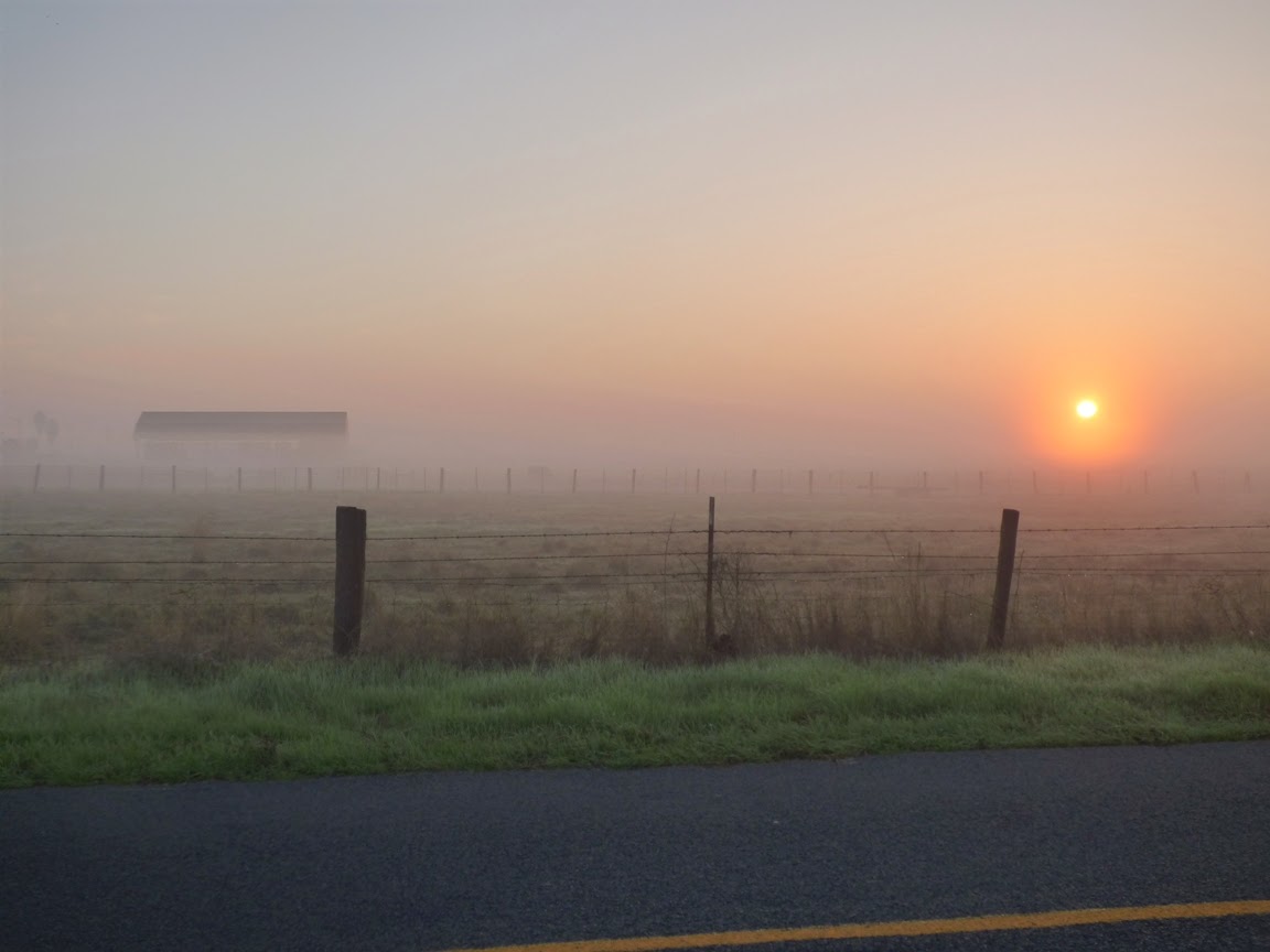
Vernal swales on the summit area of Table Mountain. These have some similarity to vernal pools on the valley floor but are also different in some important respects. Click on this post for more info.
Word comes today in the Modesto Bee that a local "farmer" has been fined $160,000 and ordered to purchase conservation easements worth $1,000,000 after he oversaw the destruction of 33 acres of prime vernal pool habitat. He was in the process of converting 850 acres of leased grazing acreage to an almond orchard when his tractors "deep-ripped" 380 acres, including the vernal pools. He had been warned to get a ground-working permit from the U.S. Army Corps of Engineers, but he didn't do so. He was confronted by officials on September 12 who stopped the tractors, but the damage had been done. The investor responsible said only that "I want to farm. That's all I want to do". No, he wanted to cash in, pure and simple. He knew he was flouting the law, and the penalty is appropriate.
Vernal swale on Table Mountain above Jamestown in the Sierra Nevada foothills
Vernal pools are one of the most unique aspects of the California prairie of the Great Valley and lower foothills of the Sierra Nevada. Many endemic species thrive in the pools, and they provide an incredible show of wildflowers in the spring (See this post for an example of the richness of the environment). They are a precious resource that deserve protection, and indeed many of the remaining pools are being preserved, at least on paper. They are defenseless against lawless land-developers, apparently.

There is very little of the original California prairie left, no more than five or ten percent. A lot of what is left has already been altered by grazing, but such lands are not getting particularly worse under that form of land use. It seems we hear that this new development or that one will only take only a few more acres, and a few more. Repeat over and over, and the last of the pools will be gone, especially if the politicians go through with their plans to restrict the power of the Environment Protection Agency and other government organizations to do their jobs and enforce the law.
Vernal pool east of Modesto
As the Bee article points out, People can comment on the proposed penalty by Dec. 18 by emailing r9hearingclerk@epa.gov or sending mail to Steven Armsey, U.S. Environmental Protection Agency, Region IX, 75 Hawthorne St., San Francisco, CA 94105. I hope you will consider writing and supporting the penalty. The water pirates are trying to cash in on the almond craze, and this landscape can ill-afford to be abused in this way. The water isn't there for the long term, and the orchards will die. But not before they've pulled every little bit of short-term profit they can.

Read more here: http://www.modbee.com/news/local/oakdale/article4005292.html#storylink=cpy
So many trees, so little water to keep them alive. But profit is profit.
It's a crime that the last vernal pools are being destroyed this way, and it is ultimately for a money-making scheme that is futile anyway. I talked about the groundwater issue a few months ago, and I am cutting and pasting the information below. Water is the ultimate controlling factor that will leave this as a wasted, barren landscape.

From March 14, 2014: The Water Pirates: A Can a Day is All We Ask (plus 107 million gallons)
New orchard on the California prairie
It's a sad and familiar story for California: there is a valuable resource in the ground, free for the taking. There are those who come to exploit the resource, tearing up the land and leaving behind a wake of destruction. There are no laws to control the behavior of the miners, except for a few arcane rules from a previous century. In the end the resource is gone, and so is the chance for any sustainable use of the land for future generations. In the end, it was all about money, which landed in the hands of a few powerful people. It certainly didn't benefit the ones who did all the physical work.

This could describe the effects of the California Gold Rush of the 1850s, but unfortunately it is not. It is a story that is happening right now in my neck of the woods (prairie?), and the worst of the destruction still lies ahead. And right now, there isn't a whole lot anyone can do to stop it. It's not gold, it's water. And despite the fact that gold is worth somewhere around $1,000 an ounce, the water is far more valuable.

Our local paper, the Modesto Bee, has been running a series of reports recently including this one by reporter J.N. Sbranti that should receive much wider exposure. Almonds have become a valuable and profitable commodity these days, and there is a wild rush on to plant as many acres of almonds as possible. In many cases farmers are simply switching from corn or other yearly crops and putting in orchards. The most destructive aspect, however is the planting of some 30,000 acres of almonds and other nut trees on the former prairie and grazing lands east of Modesto adjacent to the foothills of the Sierra Nevada.

The problem with the trees on the valley floor is that one can't let the fields lie fallow in the driest of years like the one we are now suffering through. The trees must be watered or they die, and they require 4 acre-feet of water per acre each year. If the water gets prohibitively expensive, so what? They'll have to pay the price.
California's version of "snow". The almonds are beautiful when they are blooming.

What's worse are those almond orchards in the foothills. They can't be irrigated by normal means, as there is no infrastructure to deliver water there from the local irrigation district. The only source of water is from the ground, and there are few if any rules regarding the use of the groundwater. The large agribusinesses simply buy up the cheap grazing lands, put in the trees, and start pumping vast amounts of groundwater to water them. According to the Sbranti report in the Bee, the 30,000 acres of new orchards are consuming 39 billion gallons of groundwater each year, which is more than is currently pumped for domestic use across the entire county. The groundwater resource is limited, and will likely be depleted in the service of these orchards. When the water runs out, the orchards will die, but the owners will have gotten their cash. All legally of course, and damn the consequences.

It's all well and good to complain about government regulations, but theoretically government exists to watch over the well-being of the citizens. When there is no governance, the pirates take over, and we all lose. There oughta be a law, but I don't hear about anyone working on it. Much too arcane a political issue. At least until the wells run dry...

Tuesday, November 18, 2014

"A City Divided!" "Rift Tears City Apart!" "Slip-Sliding Away!" "Creepiness on the Calaveras"... I Give up: "Calaveras Fault in Hollister"

Blogging has certainly given me some perspective on life at newspapers or internet news services. The title of a piece is all you've got to convince people to click through. I am constantly irritated beyond words at the clickbait out there: "She thought no one was looking. You won't believe what happened next". That kind of thing. And yet I couldn't help it. How many ways can you say a fault can be seen cutting a city in half?
If you have ever had a geology class in the Bay Area or Central Valley of California, there is a chance you went on a field trip to see the Calaveras fault where it passes through the Coast Range town of Hollister. The Calaveras, a close cousin to the better known San Andreas fault, runs through the city, and it is slowly tearing neighborhoods apart. Like the San Andreas in this region, the fault is creeping instead of storing up seismic stress, moving perhaps a quarter inch per year. Curbs, streets and foundations are all slowly cracking and moving apart.
The creep has progressed to the point of seriously damaging some of the beautiful Victorian-style homes built in the 1920s and 1930s. Several have been repaired by lifting them up and replacing the foundation beneath them.
Street and curb repairs have been ongoing, with new patches showing up on a constant basis.

These are textbook examples of the effects of fault creep. Literally. Pictures of many of these homes and sidewalks show up in geology textbooks (including one or two of my pictures) as examples of the phenomenon.
The neighborhood has been the focus of hundreds of field trip visits over the years. I would hope that the students recognize that people live in this neighborhood, and thus respect their privacy and property. There is more than enough to see from the public sidewalks, streets and parks. 
No trip in the region is complete without a visit to the DeRose Winery, especially on wine-tasting day (and no, none of my students imbibed on Saturday)! The winery, the oldest in California, is several miles south of Hollister on Cienega Road. The San Andreas fault runs right through the winery warehouse and is slowly tearing the building apart. A culvert on the south side of the building shows very well the continuing offset along the fault.
Compare the same culvert as seen in 1961...
Source: USGS
I want to provide a shout-out for the owners of the DeRose Winery. Whenever they've been open on Saturdays they've allowed our students to walk through the inside of the warehouse to see the effects of faulting on the building. It's a privilege to be able to do this, and it is greatly appreciated. Follow the links above to learn more about their operation.

If your travels ever bring you to central California in region around Monterey or Santa Cruz, it's not hard to find your way to Hollister. It's worth your time!

Monday, November 17, 2014

Dinosaurs, Volcanoes, Monsters of the Deep, and Other Stories Told by a Pile of Rocks. And Disneyland.

One of my most vivid childhood memories was Southern California Gas Company's Disneyland Night. My dad worked for the company at the time. Once a year the company rented Disneyland and practically every employee and their family showed up. It's hard to explain why this is so extraordinary, but let me try. Have you ever heard the expression "E ticket ride", referring to an event almost too exciting to bear? Disneyland used to require the purchase of a ticket book which was used to buy your way onto the rides. The A, B, C, and D tickets were for the boring slow rides like Storybook Land, It's a Small World, or the Swiss Family Robinson Tree. They were okay, but the E tickets were for the good stuff, mainly the Bobsleds. So why was Disneyland Night so incredible? They didn't dole out tickets that night. You could ride any ride you wanted, as many times as you wanted. For us kids, this was better than Christmas and Halloween combined.

On those long evenings, we would ride every ride possible, and around midnight we would be exhausted. Everything was starting to close up, but there was one last ride we could do...the train. It passed through the diorama of the Grand Canyon and then it passed onwards into the Primeval World. I'm pretty sure that every misconception I ever had about dinosaurs and ancient life was shaped by the scenes that passed before me in that dark tunnel. If you've never had the opportunity, someone (probably many, really) has it posted on YouTube (thank you, Dan Smith):


One of the associations that was imprinted on my mind was the T-Rex battling a Stegosaurus with an erupting volcano in the background. I look at the diorama today and see Apatosaurs lolling in swamps (they didn't), Tyrannosaurs standing like tripods (they didn't), and other misconceptions, but it was always the lavas in the distance behind the battling dinosaurs that I remember so well. So, what possible connection could there be between childhood memories of Disneyland and yesterday's class field trip to the Coast Ranges? Bear with me!

Our first stop of the day was at San Luis Reservoir, a major storage site for the California Water Project. Water is drawn from the Sacramento River Delta and pumped into the reservoir where it is eventually sent south through an extensive canal system. It is the largest "off-river" reservoir in the country. Shoreline erosion has removed the extensive coating of soil, exposing the underlying rocks, a unit known as the Panoche Formation, a complex of conglomerate, sandstone, silt, and claystone that was deposited in Late Cretaceous time, the final years of the Mesozoic, the dinosaur era.

The rocks seemingly defy explanation. They formed in thousands of feet of water, in the forearc basin that developed on the landward side of a vast subduction zone/trench system that existed on the west coast of North America for millions of years. The subduction zone was eventually replaced in central California by the San Andreas fault, a transform boundary between the Pacific and North American plates. The thing about these rocks is that on an ocean bottom one tends to expect to find mud and silt. Sand, pebbles, and boulders don't make sense. There are no strong currents on the ocean floor like there are in rivers. Or are there?

On river deltas and on the edge of the continental shelf where shallow ocean floor gives way to steeper slopes leading to abyssal depths sediments may be shaken loose, by earthquakes for instance. In this situation sediment gravity flows and turbidity currents form, fast-moving bottom-hugging masses of sediment moving very fast into deeper water. These masses are capable of considerable feats of underwater erosion, carving deep submarine canyons into the continental shelf. There are many examples of these along the present-day coast of California, the Monterey Canyon being one of the most famous.
Source: U.S. Geologic Survey

So, dinosaurs and volcanoes? The boulders in the Panoche Formation contain the occasional piece of granite derived from the deep erosion of the Sierra Nevada. The granite cobble is a fragment of what once were the magma chambers for a vast system of volcanoes that would have closely resembled the Andes or the Cascades. Yosemite Valley and the other exposures of granite across the Sierra Nevada were once situated miles beneath volcanoes. In Cretaceous time. Meaning dinosaurs once wandered the flanks of volcanoes right here in California!

That's kind of a stretch, isn't it? Is there actually any evidence of the actual volcanoes? And what about the dinosaurs?
The volcanoes are the easiest to prove. Most of the rocks in the photos above are volcanic in origin. They are the eroded pieces of lava flows that once adorned the summit ridges of the Sierra Nevada much as Lassen Peak and Mt. Shasta do today in the Cascades. It really stokes my imagination to pick up one of these rocks and to realize it started as a mass of molten rock that was erupted onto the flanks of a large stratovolcano off to the east. The lava flow was eventually eroded and removed, the bits and pieces being carried in a river and dumped onto a river delta at the edge of the continent. One day the edge of the continental shelf was shaken by an earthquake, and the chunk of rock disappeared into the depths, carried along by a turbulent mix of water and sediment. It came to rest on the deep ocean floor. Eventually intense compression folded and lifted up the rocks, and finally a last bit of soil washed away and the rocks were once again exposed to erosion and trampling by the feet of geologists.
Proving the dinosaurs were here is a bit harder, but it happened. In the 1930s, a young teenager from Gustine was exploring Del Puerto Canyon in the Coast Ranges looking for fossil shells. What he found instead were the remains of a Saurolophus, a duck-billed dinosaur. It was the first dinosaur fossil ever found in California. How much more exciting can that be? The dinosaur was apparently drowned in a river flood, and the carcass floated out to sea where it eventually sank to the seafloor. 
The great thing is, the fact that you can find an occasional dinosaur bone in these hills isn't even the best thing one can hope to discover. There were other creatures living in the sea, and they were terrifying. Al Bennison, the boy who found the dinosaur, also eventually discovered the remains of a Mosasaur.
The Mosasaurs were relatives of the varanid lizards, a group that also includes the Komodo Dragons that still live today in Indonesia. They were fearsome marine predators, swimming with flippers instead of clawed legs, perhaps even attacking and consuming sharks (or unwary geology professors). They reached lengths of more than 30 feet.
And that is the story told by a pile of rocks along a nearly empty reservoir in central California!
Plotosaurus is one of the genera of Mosasaurs. P. bennisoni was the species found in the California Coast Ranges.

For a description of some recent research on the conglomerates of the Panoche formation check out: http://www.searchanddiscovery.com/abstracts/html/2013/90162pacific/abstracts/green.htm