Showing posts with label Yosemite National Park. Show all posts

Saturday, April 12, 2025

Do You Think You Know the Highest Waterfall in Yosemite Valley? You Could Be Wrong!


Quick quiz: What is the name of this waterfall?
What is the highest waterfall in Yosemite Valley? Depending on the parameters one can use to determine "height", your assumption may be wrong! Most "authorities" recognize Yosemite Falls (2,425 feet/739 meters) as the highest in Yosemite Valley and North America, and somewhere around the fifth or seventh highest in the world. But it depends on how you decide to measure waterfalls. By a different metric, Yosemite Falls isn't even the highest waterfall in Yosemite Valley. It's the word "falls", in the plural, that makes the difference.

I was in Yosemite Valley yesterday, and the falls were flowing strong. There is no doubt that Yosemite Falls is one of the most stunning sights on the planet. A chance movement of a glacier 13,000 years ago forced a middling stream from its old channel to the left of the current waterfall, forcing Yosemite Creek to drop right off the edge of the sheer cliff. You can see the old channel almost hidden in the shadows in the photo above.
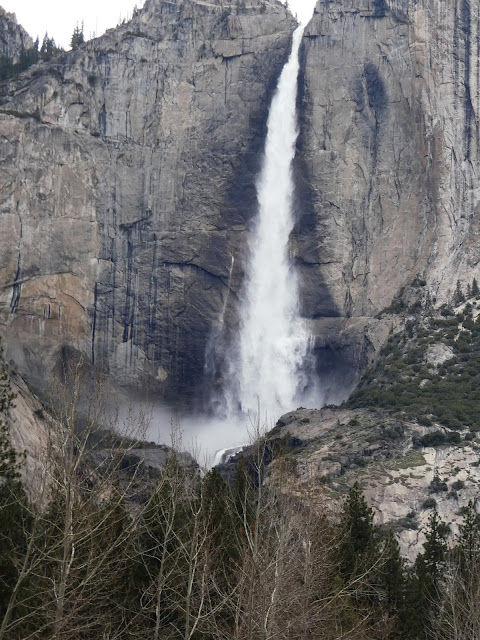
The fall makes a sheer plunge of 1,430 feet (440 meters) at the Upper Fall and then cascades through a series of steep ledges called the Middle Cascades for 675 feet (206 meters). There is a final drop of 320 feet (98 meters) at Lower Yosemite Fall. The Middle Cascades are generally hidden from view unless you hike the steep trail up to the top of the falls (below).
Part of the Middle Cascades (April 2003)
But if one decides to be a purist about such things, one can define a waterfall's height on the basis of the greatest freefall. By that metric, Yosemite Falls still is an imposing 1,425 feet (739 meters) high. But it also means it's not even the tallest waterfall in Yosemite Valley.

Many first-time visitors to the valley are drawn to Bridalveil Falls (620 feet/189 meters) because it is the first major waterfall visible as one enters the valley. But when standing at the base of Bridalveil, they may see another high waterfall across the valley west of the sheer cliff of El Capitan and wonder if it is Yosemite Falls. It's not. It's called Ribbon Fall, and it has a single drop of 1,612 feet (491 meters). That's nearly 200 feet higher than Upper Yosemite Falls (it's the one in the picture at the top of the post). It is less familiar than many of the other waterfalls because it is usually dry by June when the majority of people visit the park. But if you get the privilege of seeing by visiting in the spring, you are in for a treat.
Ribbon Fall (1,612 feet) to the left with the 2,900 foot cliff of El Capitan to the right

Ribbon Falls is one of many treasures that make a spring visit to Yosemite Valley a worthwhile endeavor. If you want to see another springtime waterfall over a thousand feet high, check out Sentinel Falls.

Friday, March 25, 2022

A Tale of Two Pullouts: Yosemite Valley From a Different Angle

El Capitan and the Merced River from the east

I know that I am truly privileged living as I do only a two-hour drive from one of the most sublime places on Earth, Yosemite Valley and the Sierra Nevada. We head up there two or three times a year, sometimes with students in tow, and sometimes on our own, so in 30+ years we've been there at least 100 times.

And I never get tired of it.

Part of the allure is seeing the seasonal changes. Winter provides the coating of snow, while fall provides the changing colors of foliage. Spring offers surging waterfalls and wild river flows. Summer provides...well...crowds, but also nice moments in places we learn of where the crowds can be avoided. We have favorite meadows and lakes for instance where people rarely stop. No matter when or where we visit, there always seems to be something new or different.

The Cathedral Spires are tucked away on the east side of the Cathedral Rocks at Bridalveil Falls
I know how it is if one gets to see Yosemite Valley for the first, and maybe only time. I've had that experience at so many other places around the world. The time available may be very limited, one may be part of a tightly controlled tour, and no one wants to miss any of the most famous views or hikes. And so it is that there is the required stop at Tunnel View, Bridalveil Falls, Cook's Meadow for the view of Yosemite Falls, and maybe Ahwahnee Meadow for a view of Half Dome. The walk to Lower Yosemite Falls, or Nevada Falls. And the Visitor Center. It makes for a full day, and a fulfilling day too. One of the most spectacular days you might ever experience.

And I never get tired of it. I'm perfectly happy to hit those same spots on my 101st trip to the valley. The season, the time of day, and the weather all conspire to make each stop a unique experience of wonder. But sometimes there are changes of a different nature, and that makes some trips really memorable. That is what today's collection of views is about.
Sentinel Rock rises above the south side of Yosemite Valley across from Yosemite Falls
Since the time that Yosemite Valley became a park, suppression of all forest fires has been the official policy. It was not however the natural condition of the parkland, nor was it the normal condition of the valley floor over the last few thousand years when it was managed by the original inhabitants of the region. 

The Ahwahnechee people, with roots among the Miwok and Paiute peoples of both sides of the Sierra, depended in large part on the acorns of the Black Oak and grazing animals like deer or bighorn in Yosemite Valley. It was in their best interest over the centuries to allow fires to burn through the valley floor and hold the quick-growing conifers at bay. When the park administrators put an end to the fires, the pine and cedar trees choked out meadows (only 65 acres of the original 750 acres of meadows remain) and grew into impenetrable thickets, blocking views of the canyon walls above.

What's worse is that choking off small fires can cause a buildup of fuel in the forest that could only lead to much worse fires than usual. This was always a danger, but it is far more hazardous today in a time of warming climate and extended droughts. Every Californian is fully aware of how wildfires in the state have morphed into monstrous events without parallel in written history.

The National Park Service has come around in their fire philosophy, especially after extensive fires a few decades ago in Yellowstone and Mesa Verde National Parks. They have instituted new policies of prescribed fires and selective tree removal to make the parks safer, but also to enhance the experiences of park visitors. In what way? The views.
The distinctive profile of the Three Brothers is the result of parallel jointing, or fractures in the granite that occur as the rocks are exposed by erosion
There are the parking lots that attract the majority of park visitors, but on the roads that loop around the valley there are many small pullouts, enough for perhaps three or four cars. In years past there seemed no real purpose for them, as they were surrounded by thick forest and offered no views or trailheads. On our visit a week ago, I found that two of those previously uninteresting pullouts had had the forest thinned out, and that they now possessed some outrageously spectacular views! The familiar iconic cliffs were there, but from angles I had never really seen before. In particular there was the long vertical cliff extending east from El Capitan, a view of the rarely seen Cathedral Spires (as opposed to the Cathedral Rocks at Bridalveil Falls), the vertical pillar of Sentinel Rock (often missed by people staring at Yosemite Falls), and the Three Brothers, which have never really had a designated viewpoint and are usually hidden by the tall trees. Upper Yosemite Fall was visible as well, perhaps farther away, but how many of you Yosemite veterans can recall seeing the falls with not a single other person in sight?
Yosemite Falls from a pullout west of Swinging Bridge
We had a leisurely lunch at the pullouts and wandered about taking pictures, and only two or three cars pulled off the road, and no one else actually got out. Except for the noise of passing traffic on a crowded Sunday afternoon, we literally had the best of Yosemite Valley to ourselves.
Prescribed fire in Yosemite Valley, with Half Dome and Clouds Rest in the distance.
We stayed at the park through Monday morning, and when we stopped by Tunnel View we witnessed another chapter in the new fire/forest regime: the ignition of a prescribed fire. It was done in March because the ground was still damp enough to prevent the uncontrolled spread of the fire. If you are on Facebook and would like to know more about forest management in Yosemite, check out (1) Yosemite Fire and Aviation | Facebook.


Friday, January 21, 2022

I'm Occasionally Reminded I'm Near an Extraordinary Mountain Range: John Muir's Range of Light

It was one of those rare days of winter in the Great Valley of California. Recent rains have tamped down the dust, and gusty winds chased away the omnipresent haze. As a result, I was treated to a view of the mountain range that I live next to, but rarely see: the Sierra Nevada, John Muir's Range of Light. It is such a rare view that I have to realign my internal geography to recognize the peaks on the skyline. It's a special view, though. Almost all the high peaks lie within Yosemite National Park, one of my most treasured places.

I hike almost daily on the Tuolumne River Parkway Trail which climbs a short bluff to bypass the town's small water treatment plant. On clear days I am treated to a view towards the Sierra Nevada to the east, and a portion of the Diablo Range of the California Coast Ranges to the west. The most distant peaks, Mts. Lyell and Rogers Peak, are 80 miles away as the crow flies, so the initial peak identification is daunting. The distinctive shapes of the peaks are clearer at extreme zoom, so in the top picture I can identify Mt. Maclure on the far right, Mt. Simmons near the center, and below Simmons, almost invisible, the summit portion of Half Dome in Yosemite Valley! Cal Topo has a marvelous tool for identifying landmarks, as you can see below.

Source: Cal Topo
Mt. Clark and Gray Peak are the prominent peaks in the picture below. They are part of the Clark Range, a high spur that lies a number of miles west of the main Sierra Crest.

The next picture reveals the peaks south of Maclure. The three prominent triangular peaks (properly called glacial horns) from left to right are Mts. Maclure and Lyell, followed by Rogers Peak. Rogers is the only peak that is actually on the Sierra Crest, although Lyell is only a fifth of a mile away (the crest being defined as the ridge that separates west-flowing stream from those flowing east into the Owens Valley).
The last picture reveals Merced Peak (under the left side of the bird flock). It is part of the Clark Range. The Tuolumne River flows in the foreground.
The cabin fever resulting from pandemic isolation and winter conditions in the mountains is intense. I'm really looking forward to a chance to get back up into the mountains come spring and summer. But it is always nice to get a reminder that the mountains are there.
 

Wednesday, August 4, 2021

A Different Kind of "Other": Yosemite of the Pandemic

Half Dome from Sentinel Bridge
I've spent a fair amount of time writing about "The Other California", the spectacular places we have in our state that don't tend to show up on postcards. But sometimes there are decent reasons to visit the places that are on the postcards. This is especially true with Yosemite Valley and Yosemite National Park. There are few places on Earth as spectacular as the granite cliffs and towering waterfalls. But summer isn't that time. It's hot and dusty, the waterfalls are dry or nearly so, and the crowds and traffic are...simply awful. It's my least favorite time of year.

But sometimes events conspire. A pandemic continues to rage across the country in large part because a significant proportion of the population refuses to mask up or get a vaccination. As a result, the National Park Service instituted a reservation system at Yosemite National Park, limiting the number of daily visitors. And despite the desperately dry conditions caused by the intense drought, there were a number of monsoon-related thunderstorms in the High Sierra in the last few weeks. Mrs. Geotripper and I decided to give the valley a chance, so I carefully watched the reservation site (recreation.gov) and caught a cancellation. We headed up the hill on Monday. 

The view from Swinging Bridge of Yosemite Falls
It was a different world in Yosemite Valley. Two years ago we paid a visit on Labor Day weekend (our out-of-town visitors couldn't come any other time), and it was absolute mayhem. There was an hour-long wait at the entrance station, and a two-hour long traffic jam that resulted in a single parking spot for the day with no chance for exploration (the trams were stuck in traffic too). But Monday there was no waiting to get into the park, and there were parking spots available everywhere, even the ones usually most impacted, like Swinging Bridge, and Sentinel Bridge. The weather was warm, verging on hot, but the ground was moist, the meadows still green, and Yosemite Falls was flowing. It was the kind of day that every visitor to this beautiful place deserves, and it was the kind of day that had become exceedingly rare in recent years.

There is usually a gaggle of photographers standing on Sentinel Bridge (the top picture) because of the artful possibilities of catching the reflection of Half Dome on the Merced River. We had the bridge to ourselves. Swinging Bridge (which for the record does not swing) was crowded as always, but even there the bridge was empty for a few moments and I was able to score a shot of Yosemite Falls without the aforementioned crowds in the picture.

There are lesser-known viewpoints like the one above of the Cathedral Rocks and Cathedral Spires, and on most days the three parking spots are taken. But once again we had the pullout to ourselves, and got a wonderful view of these cliffs that would qualify for national park status in any other place, but which barely catch the attention of travelers on their way out of the valley.

Another crowded spot on a normal day is Valley View at the west end of the valley. The small parking lot is usually packed, but once again there were spots available. El Capitan (left) and the Cathedral Rocks and the wispy, nearly invisible Bridalveil Falls (right) reflected on a slow-moving stretch of the Merced River.

I was going to write about the need to come to Yosemite on a weekday if at all possible, but it occurs to me that a better discussion is whether to implement a reservation system permanently. The concessionaires and surrounding communities of course depend on as many visitors as possible to thrive and maintain their profit margins. But the quality of the experience of visitors is radically diminished when they spend most of their time waiting in lines and being jostled by crowds on the trams and the trails. People expect that sort of thing at an amusement park, but that's not what our national parks were meant to be. Consider the mission of the parks: to preserve unimpaired the natural and cultural resources and values of the National Park System for the enjoyment, education, and inspiration of this and future generations. That simply doesn't happen in our most popular parks like Yosemite, Zion, Arches, and others that are bursting at the seams with tourists.

Our park system has not expanded with our population, and the budget of the park service is cut seemingly every year. The last administration actually cut the size of a number of precious parks. We need to expand the opportunities of people to experience the parks in the best way possible. 

Friday, August 7, 2020

The Way it Was: Yosemite in the Times of a Pandemic

Tunnel View, close to the spot where the valley was first "discovered" by European colonizers

The pandemic rages on, and our lives have been upended in so many ways we could never have foreseen. My heart goes out to all of those whose lives have been devastated, whether by disease, unemployment, or fear. We've been fortunate so far, and we've been careful to stay out of harm's way, staying home for the most part, wearing masks in public, and always the social distancing. 

I walk along my river almost every day to maintain sanity and health, but except for a single short excursion up north for my grandmother's funeral, we've not been out of our county since March. But this week I went online and scored an E-ticket (you have to be an older person to understand that reference): a reservation for entry into Yosemite National Park.
The park has been trying to deal with two opposing directives: opening the park as much as possible, and maintaining some degree of safety in trying to prevent the spread of the coronavirus. They settled on limiting the number of visitors by instituting a reservation system (info at reservation.gov). The goal is to have the park at about 50% of usual visitation. 80% of the reservations are available a month in advance, while the other 20% come available two days before the visitor's arrival. That's the ticket I was able to get.
We headed up as early in the day as we could, intensely curious to see what things would be like. And out of the 100+ journeys we've made to the park in the last 30 years, it was unusual to say the least. There was a long wait at the entrance station like usual, but reason was different. There were fewer people, yes, but it took longer to confirm everyone's identity (the reservations aren't transferable). Once inside the park, the transformation was remarkable. There was very little traffic on the road, and there were spots available in every parking lot that we could see. The lot at Tunnel View (the top picture in this post) was only half full. And no buses were idling.
We headed up Glacier Point Road and had a long lunch at Summit Meadow, and we had it almost entirely to ourselves (admittedly not one of the 'destination spots' for visitors, but still...). We stopped at the nearly empty parking lot at Washburn Point, and then headed to Glacier Point, which was also only half full. It seemed a different world than from our 'normal' Yosemite experience. The picture below of Glacier Point was not cropped to remove people; that's how many were actually there.
After so many months of sheltering in place, it felt so good to get out of the valley and see the high country of the Sierra Nevada. We've missed it so much.
We drove back down to the floor of Yosemite Valley and found the valley to be equally devoid of crowds. There were a few gatherings near the taco trucks that are serving as food purveyors while parts of Curry Village are renovated. But again, most of the lots were uncrowded. The afternoon shadows were lengthening as we passed Sentinel Bridge and Lower Yosemite Falls (the merest trickle in this dry year), and we made our way down to Valley View.
When Yosemite Falls is dry, Yosemite Point takes on an entirely different perspective. It's the prominent cliff that is still lit by the sun on the right in the picture below. Yosemite National Park is like that...there are those most famous cliffs like El Capitan and Half Dome that dominate people's experiences, but there are dozens of lesser-known rock cliffs and spires that in any other place would be national parks and monuments in their own right.
The Cathedral Rocks are one of those cliffs. They are the incredible cliffs in the picture below. They are behind you when you stare up the vertical face of El Capitan. I don't recall ever seeing them on the t-shirts and coffee mugs in the curio shops (although I don't spend a lot of time in the shops when I'm in the valley).
We made our last stop at Valley View where we could enjoy the evening light on El Capitan, Bridalveil Falls, and the other (better-known) side of the Cathedral Rocks. The Merced River was a beautiful reflective pool at this time of low water.
We noticed an American Dipper foraging in the water. It's one of the few songbirds that regularly swims. Also called the Water Ouzel, it was one of John Muir's favorite Sierra birds. I've only seen them a few times.
We saw a Black Bear at Crane Flats. There has been a lot written about the resurgence of wildlife in the absence of the usual crowds of humanity at Yosemite. It was simply napping away at the edge of the meadow and no one was bothering it. On the whole, Yosemite National Park was a delightful place to visit that day, a far cry from what we experienced during our Labor Day visit a year ago when we experienced bumper-to-bumper traffic jams, no parking, and no chance to see the sights. It wasn't fun for anyone that day.

We need to reconsider the role of our national parks in our national life. They are precious places, and we are loving them to death. Yosemite certainly isn't alone in this regard. Arches and Zion national parks in Utah in particular have become so crowded that few are able to experience and enjoy them in any meaningful way. I hate to say we need to keep a reservation system like this in place, but at the same time we also need to make more places available to our population. 

One of the most egregious acts by the present administration was the destruction of two of our most significant national monuments, Bear's Ears, and Grand Staircase-Escalante. These parks are within an easy day's drive from Zion, and offer equally spectacular natural experiences. But they were eviscerated by the administration, Grand Staircase by 50%, and Bear's Ears by 90%. We need these parks, and more. It's something to consider as we enter into a bitter election season. Which party is better equipped to safeguard our national treasures?

And that's the way it was in Yosemite. Words can barely describe the beauty and serenity of the day.

Friday, January 3, 2020

Getting to Know Special Places: An Invitation to Explore the Tuolumne River (And Birds! Lots of Birds)


Not all of you know that I actually have two blogs. Geotripper has been active since the late Paleozoic of cyberworld (2008), but I've also been producing Geotripper's California Birds since 2014. I came to love birds at first because of some journeys to the Hawaiian Islands where I was introduced to the unique native species there. Then I ended up with a pretty powerful camera lens that allowed me to see our local birds up close, and from then I was hooked.

I started writing (and just posted) a year-end summation of our bird discoveries this year on the Tuolumne River Parkway Trail, and by the time I finished, I realized I had written a fairly extensive description of my 'special place', the kind of place I wrote about in the previous post about seeing as much of the world as possible. So here is a description of my place, along with the absolutely fascinating birds that are found there.
The first bird of 2019 near the Tuolumne River

The Tuolumne is one of the most spectacular rivers in North America, with its headwaters in the alpine country of Yosemite National Park. It flows through a gorge as deep as the Grand Canyon, is trapped for a time in Hetch Hetchy Reservoir, and then flows free again for a number of miles before being trapped again in Don Pedro Reservoir. After that, the river flows unimpeded until it joins the San Joaquin River near the Sacramento Delta. The stretch I walk almost daily is a two mile trail (the Tuolumne River Parkway) where the river emerges from the Mother Lode of the Sierra Nevada into the Central Valley.
High water, 2017. At around 15,000 cfs, portions of the trail are underwater.

The river has many moods. Although the flow is controlled by the dams upstream, there are times when the dams have to open their spillways to prevent them being overwhelmed by floodwaters. For much of the year, the flow is artificially kept at around 200-400 cubic feet per second (cfs). During 'normal' years, there will be a few 'surge' flows to help the salmon runs, and the water will reach 2,000-3,000 cfs. But in emergencies, the flows will reach 18,000 cfs or more (the worst ever was 1997 when the flows reached a record 70,000 cfs). At 15,000 cfs, almost the entire floodplain is inundated and portions of the trail end up underwater (see above, from 2017).
The first Bald Eagle to be reported officially on the Parkway Trail
I don't see many mammals on my walks (squirrels of course, and the occasional river otter or fox), but the birds are an ever-changing drama, as you have no doubt noticed if you follow this blog. I have become a familiar sight to the river 'regulars' as the quirky old man who is always looking up and taking pictures of birds. I was astounded to discover the variety of birds who call the river home (or their migration stopover).
Western Tanager, a summer migrant along the river. One our most colorful species.
I have been counting all of the birds I've seen on my excursions. They get reported on e-Bird, which is one of the main citizen science birding organizations. With thousands upon thousands of reports daily, E-bird is able to track the numbers and movements of bird species all over the world, and the data is available online. When you enjoy numbers the way I do, you'll understand how easy it can be to get lost for hours on their website. It might seem overwhelming at first, but e-Bird encourages reports every day, and not just for unusual or exotic species. They also want to know what is happening in backyards and urban parks as well. Over time, we'll be able to see the effects of global warming on bird migration and populations, so the reports, however mundane they might be, are extremely important.
A Hooded Oriole. They nested on the bluffs this year and usually head south in the winter, but two of them remained in late November, the only ones reported in Central California
This was the first year when I have made at least one bird report of each week of the year, and my counts along with those of several other birders have revealed the diversity of bird life on this long abused river environment. In 2019, 116 bird species were reported. That placed the Tuolumne as the sixth most diverse birding "hot spot" in our county, behind only the Modesto Wastewater Treatment Ponds (!), and four sites within the San Joaquin River National Wildlife Refuge (that's for the year; for all time, the river trail is tied for 20th out of more than 100 hot spots in the county).
A Rufous Hummingbird along the river. I saw only a couple this year as they migrated through the region.
Walking along the river, one becomes familiar with many of the individual birds. There are the year-round residents: California Scrub Jays, Northern Mockingbirds, European Starlings, Eurasian Doves, Yellow-billed Magpies, Belted Kingfishers, and Canada Geese. A different group hangs out at the water treatment ponds midway along the trail: Killdeer, Greater Yellowlegs, Spotted Sandpipers, Least Sandpipers and Black Phoebes. There are three woodpecker species that can be seen nearly every day, Acorn Woodpeckers, Nuttall's Woodpeckers, and Northern Flickers. A pair of Mute Swans have raised several broods in the quarry lake across from the western trailhead.

A female Phainopepla. The males are entirely black.
Then there are the migrants, those that are resident for only part of the year. The spring and summer brings the colorful tropical birds from Mexico and Central America. They include the Western Tanager, the Black-headed Grosbeak, the Bullock's Oriole, the Hooded Oriole, and the Rufous Hummingbird. I'm a sucker for bright colors, so these are my favorite birds to see. I catch my breath every time I spot one of the them and I'm tense all through March and April waiting for their first arrival (although I had a tremendous shock in November, having two sightings of extremely unseasonable Hooded Orioles). The Phainopepla is another tropical favorite whose range is extending northward, and I've seen them at odd times throughout the year.
A male Bullock's Oriole. Like many birds, the females are less colorful.


The spring also brings the swallows, the Barn Swallow, Tree Swallow, Cliff Swallow, and Northern Rough-winged Swallow. The sky is sometimes filled with hundreds of them.


American White Pelicans occasionally fly over the Tuolumne River
The raptors are always around, including Red-tailed Hawks, Red-shouldered Hawks, Swainson's Hawks, Turkey Vultures (check this link for a 'cute' baby vulture 'smoking' a cigarette), Ospreys, Cooper's Hawks (see photo above), and American Kestrels. I had a single sighting this year of a Northern Harrier, and a Sharp-shinned Hawk.
The shallows of the Tuolumne provide good fishing for the Osprey (also known as the Sea Hawk).
There were the single sightings this year...a flyover of Sandhill Cranes, several kinds of duck passing through, including Ring-necked, and Buffleheads, a Blue-gray Gnatcatcher, a Red-breasted Sapsucker, and several flycatchers and warblers.
Red-breasted Sapsucker, seen just once this year along the Tuolumne.
What did I miss seeing the most? My most desired sightings are a pair of blue-colored birds: the Lazuli Bunting, and the Blue Grosbeak. I saw a Bunting in 2018, and I saw both birds this year along other parts of the river. But I didn't see any this year on the Parkway Trail. Anyone want to guess what I'll be watching for in a few months?
Lazuli Bunting at Ceres River Bluff Regional Park, downstream of the Parkway Trail

I saw a Blue Grosbeak several times, at the Ceres River Bluff Regional Park downstream from the Parkway Trail, and I was especially surprised to find the bird upstream at Robert's Ferry Bridge. To make the experience even stranger, I saw a bobcat a few moments later. Our region is at the extreme north end of the range of this tropical bird.
Blue Grosbeak at Ceres Bluff Regional Park, downstream of the Tuolumne Parkway Trail
The highlight of the year? I saw a bird seen in Stanislaus County only four times previously: a Rose-breasted Grosbeak. It's a bird whose range is really in the eastern U.S., but a very few wind up in California. I was tracking some Black-headed Grosbeaks, and this individual flew by and landed in a nearby oak long enough for a couple of pictures (which I'm glad I got; I don't think anyone would have believed me without them). It was a thrilling moment for me and the four other birders who made out to Waterford in time to see it.

If you are a glutton for punishment, here is the complete list of all the Tuolumne River's 116 birds seen in 2019 (the all-time list numbers 133 species). If you click on the name, you'll be taken to eBird description of the species. If you want to contribute to the 2020 list, you can find it here: https://ebird.org/hotspot/L2153651?m=&yr=cur&changeDate=Set. I'm still an amateur at this, and would love the help of sharper-eyed people than myself. Who knows what we can find this year!
1 Canada Goose
2 Mute Swan
3 Wood Duck
4 Common Goldeneye
5 Eurasian Collared-Dove
6 Mourning Dove
7 White-throated Swift
8 Least Sandpiper
9 Greater Yellowlegs
10 California Gull
11 Great Egret
12 Red-tailed Hawk
13 Belted Kingfisher
14 Acorn Woodpecker
15 Nuttall's Woodpecker
16 Northern Flicker
17 American Kestrel
18 Black Phoebe
19 California Scrub-Jay
20 Yellow-billed Magpie
21 Ruby-crowned Kinglet
22 Blue-gray Gnatcatcher
23 European Starling
24 Northern Mockingbird
25 Cedar Waxwing
26 House Finch
27 White-crowned Sparrow
28 Golden-crowned Sparrow
29 Orange-crowned Warbler
30 Yellow-rumped Warbler
31 Ring-necked Duck
32 Wild Turkey
33 Spotted Sandpiper
34 Double-crested Cormorant
35 Great Horned Owl
36 American Crow
37 Lincoln's Sparrow
38 Pied-billed Grebe
39 Rock Pigeon
40 Anna's Hummingbird
41 Bonaparte's Gull
42 Bushtit
43 White-breasted Nuthatch
44 American Robin
45 House Sparrow
46 American Goldfinch
47 Dark-eyed Junco
48 Killdeer
49 Lesser Goldfinch
50 Sharp-shinned Hawk
51 Red-shouldered Hawk
52 Oak Titmouse
53 Downy Woodpecker
54 Northern Pintail
55 California Towhee
56 Spotted Towhee
57 Snowy Egret
58 American Wigeon
59 Cooper's Hawk
60 Hooded Oriole
61 American Coot
62 Western Bluebird
63 Green Heron
64 Northern Shoveler
65 Bufflehead
66 House Wren
67 Turkey Vulture
68 Hermit Thrush
69 Lesser Yellowlegs
70 Northern Harrier
71 Barn Owl
72 Phainopepla
73 Brewer's Blackbird
74 Great Blue Heron
75 American White Pelican
76 Hooded Merganser
77 Greater White-fronted Goose
78 Western Meadowlark
79 Mallard
80 Sandhill Crane
81 California Quail
82 Song Sparrow
83 White-faced Ibis
84 Osprey
85 Red-breasted Sapsucker
86 Western Wood-Pewee
87 Western Tanager
88 Warbling Vireo
89 Black-throated Gray Warbler
90 Wilson's Warbler
91 Barn Swallow
92 Black-chinned Hummingbird
93 Willow Flycatcher
94 Bullock's Oriole
95 Cattle Egret
96 Rufous Hummingbird
97 Cliff Swallow
98 Ash-throated Flycatcher
99 Western Kingbird
100 Black-headed Grosbeak
101 Northern Rough-winged Swallow
102 Tree Swallow
103 Wrentit
104 Swainson's Hawk
105 Forster's Tern
106 Rose-breasted Grosbeak
107 Brown-headed Cowbird
108 Cinnamon Teal
109 Townsend's Warbler
110 Olive-sided Flycatcher
111 Common Merganser
112 Black-necked Stilt
113 Savannah Sparrow
114 Bald Eagle
115 Say's Phoebe
116    Fox Sparrow