Showing posts with label Half Dome. Show all posts

Sunday, January 7, 2024

A Rare Day for the Great Valley: The Sierra Crest, and a bit of Half Dome

California's Great Valley is many things: one of the most important agricultural regions in the world, America's Serengeti Plains where millions of migratory birds spend the winter, and one of the most polluted air basins in the country. The pollution is a shame, causing all manner of health problems for those who live here, and obscuring the incredible mountains that ring the valley. Except on a few select days out of the year. Today was one of those days.
Gray, Red and Merced Peaks in Yosemite National Park
We had a fairly intense storm last night, and it was followed up by windy cold conditions that cleared the air. I took my customary walk along the Tuolumne River Parkway Trail. A section of the trail follows the bluff and on days like this, I get a wonderful panorama of the Sierra Nevada covering Yosemite National Park. A zoomed-in look provides a view of Gray, Red and Merced Peaks in the southern part of Yosemite (above).
A shift to the north reveals the high peaks of the Sierra Crest, including Mt. Maclure, Rodgers Peak, and Mt. Lyell, three of the higher peaks in Yosemite National Park (Mt. Dana, the 2nd highest, isn't visible). Some of the foreground peaks are rather famous as well. Mt. Starr King and Sentinel Dome are visible, and at the very left edge of the photo is the top portion of Half Dome! It's hard to pick out, but the CalTopo provides some identification of the different peaks. 
Source: https://caltopo.com/view#ll=37.6344,-120.7662&e=15&t=n&z=9&c=0.31,85.35
There are better views of Half Dome from the valley floor (the intersection of Oakdale-Waterford Highway and Keyes Road is much clearer on days like this). I couldn't get any pictures today, but here's one from a different day (see some more at https://geotripper.blogspot.com/2019/02/it-was-that-kind-of-day-half-dome-from.html). 
A wonderful day.


Sunday, October 30, 2022

How It Was Today: Fall in Yosemite Valley

How it ended...

How it began...
I woke up late this morning. Mrs. Geotripper was finishing breakfast and asked if I'd like "to go up the river a little ways and find some fall colors". I had lots of grading to get through, so obviously I said yes, and around 11 or so we jumped in the car and headed up the Tuolumne River to see what we would find. There wasn't much, at least not in terms of fall color. So we went a little farther...
We followed Highway 132 up past Coulterville and on to Greeley Hill at a bit above 3,000 feet. Still not much in the way of fall color. So we went a bit farther up the hill and found ourselves at the Yosemite National Park entrance station at Big Oak Flat at 4,000 feet. We finally found a bit of color, although not at the intensity that a few more days of cold weather might bring. 
And we had made it this far, and Yosemite Valley was only 15 miles away. How could we pass it up? 
So on we went into the awesome gorge of the Merced River and into the valley itself. There was the first look at the distant cliffs of El Capitan (left), Half Dome (center), and Sentinel Rock and Dome (right).
Closer at hand were a lot of ripening acorns. The bears and woodpeckers will be happy.
We reached the valley floor and started our tour of Yosemite's greatest hits. We were surprised to find some wispy curtains of water flowing over Bridalveil Falls. The 620 foot-high waterfall is a classic example of a glacial hanging valley. The main trunk glacier flowing through Yosemite Valley was able to erode a much deeper trough than the small glacier in Bridalveil Creek, so the floor of the creek was left hanging high above the main valley floor.
It was not a cold day, mostly in the sixties, but the sun was intense. It brought out what colors there were in the oaks and dogwood trees.
We didn't see a great many varieties of birds, but there were some Acorn Woodpeckers busy collecting acorns and hiding them in tree "granaries". Such trees can have tens of thousands of drilled holes that can hold a single acorn each. The birds live in loose family groups who search for and guard their food supplies.
Yosemite Valley is not a 'typical' glacially-carved valley. Most such valleys have a U-shaped profile, and are relatively straight. Yosemite Valley is characterized instead by bold cliffs that extend out into the valley with dark recesses in-between. This is the result of having eight distinct intrusions of granitic rock, ranging in composition from 'true' granite to granodiorite, tonalite, and diorite. They differ from each other in the proportions of the minerals quartz, potassium feldspar, and plagioclase. They also vary in the amount of dark minerals they contain including biotite mica, hornblende, and a little augite. They also vary in their pattern of fracturing (jointing), and this is expressed in differing vulnerability to erosion by ice, water, and mass wasting (landsliding and rock falls).
Sentinel Dome (above) is a good example. It is composed of fairly resistant Sentinel granodiorite, but it is jointed and thus forms a somewhat narrow high cliff that looms over the valley.
Yosemite Point on the other hand is composed mostly of unjointed El Capitan granite and forms a wide bold cliff. Sometimes people sort of 'miss' this incredible cliff because much of the time there is a stunning waterfall pouring off the west flank of the precipice (the dark mark on the left side in the picture below). That waterfall is only fifth or seventh highest waterfall in the world, and is known by the moniker of Yosemite Falls, measuring in at 2,425 feet. It wasn't actually dry today, but one needed binoculars to see the small trickle at the top of the cliff.
The autumn season is one of the best times to view Half Dome from the middle of Sentinel Bridge. The Merced River is flowing at a low ebb and the still waters make for memorable reflections. Half Dome is another example of an unjointed monolith of granitic rock called the Half Dome granodiorite. It is the youngest of the igneous intrusions exposed in the valley, with an age of about 84 million years. The Sentinel granodiorite is about 88 million years, and the El Capitan granite around 103 million years. These dates fall within the Cretaceous period, which means that when these molten masses were intruding the crust, there were dinosaurs wandering the surface four or five miles above. The dinosaurs would have experienced occasional volcanic eruptions when some of the intruding magma escaped to the surface.

In the years since, erosion has removed the miles of overlying rock and dumped it into the Central Valley or the waters off the coast of ancient California. The region seems to have been eroded to a low elevation landscape that was later uplifted to form the modern Sierra Nevada.
We wandered around Cook's Meadow and stopped into the store at Curry Village to replenish my t-shirt collection. The sun was starting to get low, so we made our way west to our favorite evening viewpoint, Valley View.
Valley View is almost a secret to Yosemite visitors because it has a small parking lot (maybe room for ten cars) at a blind curve so that if you are in the right-hand lane you might miss it. Since the road is one-way at that point, you would have to repeat a five mile loop to get back. The small parking lot is a blessing because it limits the size of the crowd. It's a quiet spot to enjoy the fading light on the cliffs of El Capitan and the Cathedral Rocks. The river usually flows slowly here making for memorable reflections of the cliffs above. We enjoyed the few moments of peace, and then headed home.
And that's the way it was today...
 

Friday, January 21, 2022

I'm Occasionally Reminded I'm Near an Extraordinary Mountain Range: John Muir's Range of Light

It was one of those rare days of winter in the Great Valley of California. Recent rains have tamped down the dust, and gusty winds chased away the omnipresent haze. As a result, I was treated to a view of the mountain range that I live next to, but rarely see: the Sierra Nevada, John Muir's Range of Light. It is such a rare view that I have to realign my internal geography to recognize the peaks on the skyline. It's a special view, though. Almost all the high peaks lie within Yosemite National Park, one of my most treasured places.

I hike almost daily on the Tuolumne River Parkway Trail which climbs a short bluff to bypass the town's small water treatment plant. On clear days I am treated to a view towards the Sierra Nevada to the east, and a portion of the Diablo Range of the California Coast Ranges to the west. The most distant peaks, Mts. Lyell and Rogers Peak, are 80 miles away as the crow flies, so the initial peak identification is daunting. The distinctive shapes of the peaks are clearer at extreme zoom, so in the top picture I can identify Mt. Maclure on the far right, Mt. Simmons near the center, and below Simmons, almost invisible, the summit portion of Half Dome in Yosemite Valley! Cal Topo has a marvelous tool for identifying landmarks, as you can see below.

Source: Cal Topo
Mt. Clark and Gray Peak are the prominent peaks in the picture below. They are part of the Clark Range, a high spur that lies a number of miles west of the main Sierra Crest.

The next picture reveals the peaks south of Maclure. The three prominent triangular peaks (properly called glacial horns) from left to right are Mts. Maclure and Lyell, followed by Rogers Peak. Rogers is the only peak that is actually on the Sierra Crest, although Lyell is only a fifth of a mile away (the crest being defined as the ridge that separates west-flowing stream from those flowing east into the Owens Valley).
The last picture reveals Merced Peak (under the left side of the bird flock). It is part of the Clark Range. The Tuolumne River flows in the foreground.
The cabin fever resulting from pandemic isolation and winter conditions in the mountains is intense. I'm really looking forward to a chance to get back up into the mountains come spring and summer. But it is always nice to get a reminder that the mountains are there.
 

Wednesday, August 4, 2021

A Different Kind of "Other": Yosemite of the Pandemic

Half Dome from Sentinel Bridge
I've spent a fair amount of time writing about "The Other California", the spectacular places we have in our state that don't tend to show up on postcards. But sometimes there are decent reasons to visit the places that are on the postcards. This is especially true with Yosemite Valley and Yosemite National Park. There are few places on Earth as spectacular as the granite cliffs and towering waterfalls. But summer isn't that time. It's hot and dusty, the waterfalls are dry or nearly so, and the crowds and traffic are...simply awful. It's my least favorite time of year.

But sometimes events conspire. A pandemic continues to rage across the country in large part because a significant proportion of the population refuses to mask up or get a vaccination. As a result, the National Park Service instituted a reservation system at Yosemite National Park, limiting the number of daily visitors. And despite the desperately dry conditions caused by the intense drought, there were a number of monsoon-related thunderstorms in the High Sierra in the last few weeks. Mrs. Geotripper and I decided to give the valley a chance, so I carefully watched the reservation site (recreation.gov) and caught a cancellation. We headed up the hill on Monday. 

The view from Swinging Bridge of Yosemite Falls
It was a different world in Yosemite Valley. Two years ago we paid a visit on Labor Day weekend (our out-of-town visitors couldn't come any other time), and it was absolute mayhem. There was an hour-long wait at the entrance station, and a two-hour long traffic jam that resulted in a single parking spot for the day with no chance for exploration (the trams were stuck in traffic too). But Monday there was no waiting to get into the park, and there were parking spots available everywhere, even the ones usually most impacted, like Swinging Bridge, and Sentinel Bridge. The weather was warm, verging on hot, but the ground was moist, the meadows still green, and Yosemite Falls was flowing. It was the kind of day that every visitor to this beautiful place deserves, and it was the kind of day that had become exceedingly rare in recent years.

There is usually a gaggle of photographers standing on Sentinel Bridge (the top picture) because of the artful possibilities of catching the reflection of Half Dome on the Merced River. We had the bridge to ourselves. Swinging Bridge (which for the record does not swing) was crowded as always, but even there the bridge was empty for a few moments and I was able to score a shot of Yosemite Falls without the aforementioned crowds in the picture.

There are lesser-known viewpoints like the one above of the Cathedral Rocks and Cathedral Spires, and on most days the three parking spots are taken. But once again we had the pullout to ourselves, and got a wonderful view of these cliffs that would qualify for national park status in any other place, but which barely catch the attention of travelers on their way out of the valley.

Another crowded spot on a normal day is Valley View at the west end of the valley. The small parking lot is usually packed, but once again there were spots available. El Capitan (left) and the Cathedral Rocks and the wispy, nearly invisible Bridalveil Falls (right) reflected on a slow-moving stretch of the Merced River.

I was going to write about the need to come to Yosemite on a weekday if at all possible, but it occurs to me that a better discussion is whether to implement a reservation system permanently. The concessionaires and surrounding communities of course depend on as many visitors as possible to thrive and maintain their profit margins. But the quality of the experience of visitors is radically diminished when they spend most of their time waiting in lines and being jostled by crowds on the trams and the trails. People expect that sort of thing at an amusement park, but that's not what our national parks were meant to be. Consider the mission of the parks: to preserve unimpaired the natural and cultural resources and values of the National Park System for the enjoyment, education, and inspiration of this and future generations. That simply doesn't happen in our most popular parks like Yosemite, Zion, Arches, and others that are bursting at the seams with tourists.

Our park system has not expanded with our population, and the budget of the park service is cut seemingly every year. The last administration actually cut the size of a number of precious parks. We need to expand the opportunities of people to experience the parks in the best way possible. 

Saturday, January 30, 2021

You Can See Yosemite Valley from the Tuolumne River! In a Manner of Speaking...

Those of you who know the layout of Yosemite National Park will also know that the title of today's post must come with some kind of caveat because any hiker or cartographer knows that the Tuolumne River in Yosemite National Park flows through a vast gorge the depth of the Grand Canyon (it's even called the Grand Canyon of the Tuolumne River). You just can't see the one valley from the other.

But...the Tuolumne River also flows across the flat plains of the Great Valley of California, and if we count "Yosemite Valley" as being also some of the significant peaks and cliffs that ring Yosemite Valley like Half Dome, El Capitan, and Sentinel Dome, you can in fact see the valley from the Tuolumne River.

This is not one of my occasional posts about the better-known spot for viewing Half Dome from Hall and Keyes Roads near Turlock. I get in enough internet trouble over that one, but it is indeed possible to see the very top of Half Dome and El Capitan from my daily walking trail along the Tuolumne River in Waterford. But the additional caveat is that it has to be a really clear day, and we have precious few of those over the course of year. Sometimes weeks can pass between sightings of any mountains at all. But following our huge storm this week, the air was crystal clear today.

The additional caveat is that you need binoculars or a good zoom lens to see the domes and cliffs. With the naked eye, the mountains are difficult to distinguish from one another. But on those rare clear days, and with the right equipment, and knowing where to look, you can indeed see some of Yosemite Valley's most famous landmarks. In a way of course it is frustrating. I'd rather be there than here, but chances will start increasing as the pandemic finally begins to subside.

If you are wondering about the cranes in the foreground, our 1964 vintage bridge is being replaced by a safer, wider bridge. The anchoring columns of the present bridge are unstable during floods; all bridges are perfectly safe, the engineers say, right up until they are not.

In any case, if you couldn't make out the various domes and cliffs and peaks in the opening picture, they are labeled below. 

If you live in the Central Valley (we call it the Great Valley) and wonder if you can see any particular Sierra peaks, check out caltopo.com and find the dropdown command for "simulated view". You can adjust the map for a view from anywhere covered by the program. Below is an example of the view I used to label the peaks shown in this post.


Friday, August 7, 2020

The Way it Was: Yosemite in the Times of a Pandemic

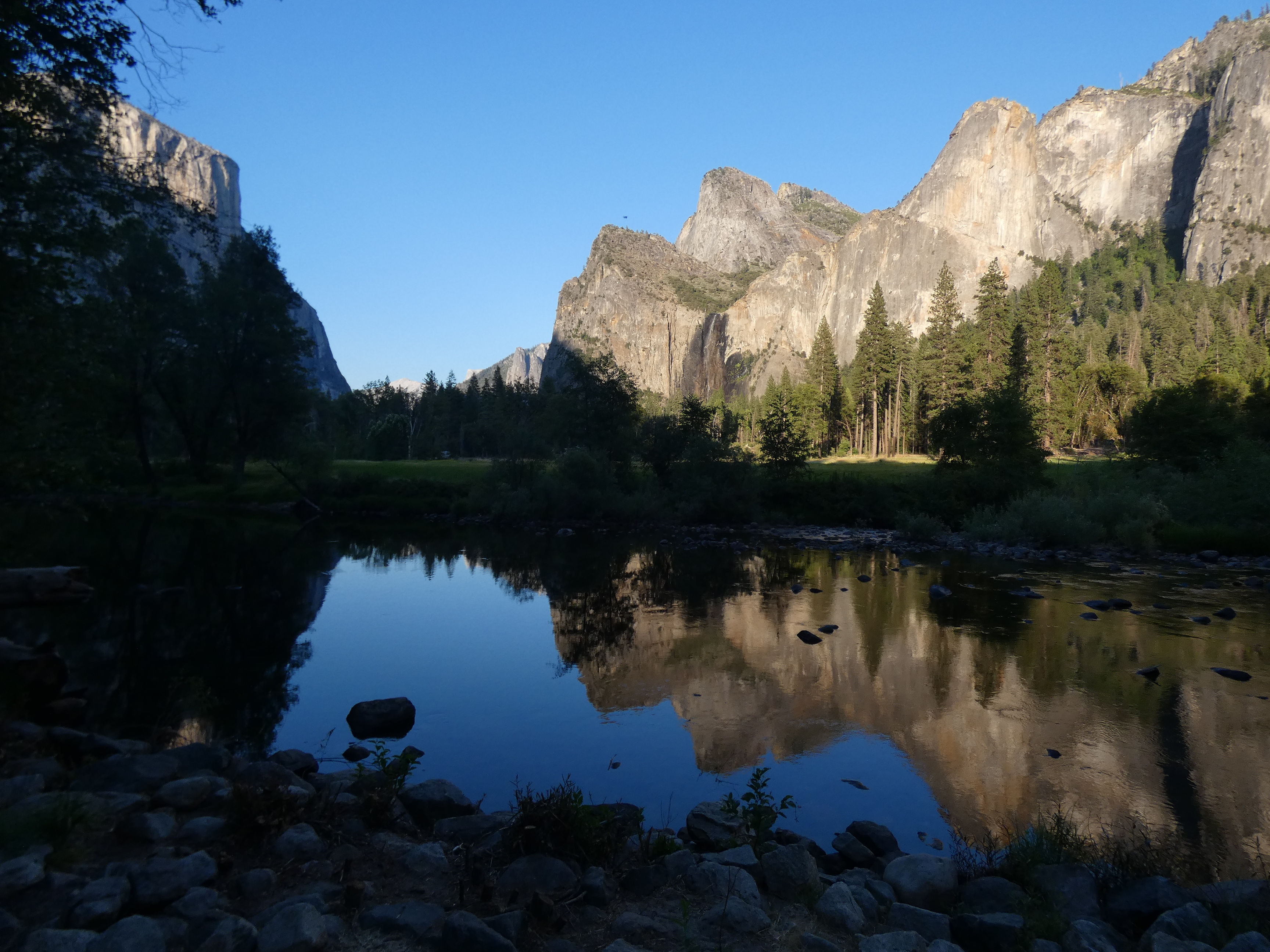
Tunnel View, close to the spot where the valley was first "discovered" by European colonizers

The pandemic rages on, and our lives have been upended in so many ways we could never have foreseen. My heart goes out to all of those whose lives have been devastated, whether by disease, unemployment, or fear. We've been fortunate so far, and we've been careful to stay out of harm's way, staying home for the most part, wearing masks in public, and always the social distancing. 

I walk along my river almost every day to maintain sanity and health, but except for a single short excursion up north for my grandmother's funeral, we've not been out of our county since March. But this week I went online and scored an E-ticket (you have to be an older person to understand that reference): a reservation for entry into Yosemite National Park.
The park has been trying to deal with two opposing directives: opening the park as much as possible, and maintaining some degree of safety in trying to prevent the spread of the coronavirus. They settled on limiting the number of visitors by instituting a reservation system (info at reservation.gov). The goal is to have the park at about 50% of usual visitation. 80% of the reservations are available a month in advance, while the other 20% come available two days before the visitor's arrival. That's the ticket I was able to get.
We headed up as early in the day as we could, intensely curious to see what things would be like. And out of the 100+ journeys we've made to the park in the last 30 years, it was unusual to say the least. There was a long wait at the entrance station like usual, but reason was different. There were fewer people, yes, but it took longer to confirm everyone's identity (the reservations aren't transferable). Once inside the park, the transformation was remarkable. There was very little traffic on the road, and there were spots available in every parking lot that we could see. The lot at Tunnel View (the top picture in this post) was only half full. And no buses were idling.
We headed up Glacier Point Road and had a long lunch at Summit Meadow, and we had it almost entirely to ourselves (admittedly not one of the 'destination spots' for visitors, but still...). We stopped at the nearly empty parking lot at Washburn Point, and then headed to Glacier Point, which was also only half full. It seemed a different world than from our 'normal' Yosemite experience. The picture below of Glacier Point was not cropped to remove people; that's how many were actually there.
After so many months of sheltering in place, it felt so good to get out of the valley and see the high country of the Sierra Nevada. We've missed it so much.
We drove back down to the floor of Yosemite Valley and found the valley to be equally devoid of crowds. There were a few gatherings near the taco trucks that are serving as food purveyors while parts of Curry Village are renovated. But again, most of the lots were uncrowded. The afternoon shadows were lengthening as we passed Sentinel Bridge and Lower Yosemite Falls (the merest trickle in this dry year), and we made our way down to Valley View.
When Yosemite Falls is dry, Yosemite Point takes on an entirely different perspective. It's the prominent cliff that is still lit by the sun on the right in the picture below. Yosemite National Park is like that...there are those most famous cliffs like El Capitan and Half Dome that dominate people's experiences, but there are dozens of lesser-known rock cliffs and spires that in any other place would be national parks and monuments in their own right.
The Cathedral Rocks are one of those cliffs. They are the incredible cliffs in the picture below. They are behind you when you stare up the vertical face of El Capitan. I don't recall ever seeing them on the t-shirts and coffee mugs in the curio shops (although I don't spend a lot of time in the shops when I'm in the valley).
We made our last stop at Valley View where we could enjoy the evening light on El Capitan, Bridalveil Falls, and the other (better-known) side of the Cathedral Rocks. The Merced River was a beautiful reflective pool at this time of low water.
We noticed an American Dipper foraging in the water. It's one of the few songbirds that regularly swims. Also called the Water Ouzel, it was one of John Muir's favorite Sierra birds. I've only seen them a few times.
We saw a Black Bear at Crane Flats. There has been a lot written about the resurgence of wildlife in the absence of the usual crowds of humanity at Yosemite. It was simply napping away at the edge of the meadow and no one was bothering it. On the whole, Yosemite National Park was a delightful place to visit that day, a far cry from what we experienced during our Labor Day visit a year ago when we experienced bumper-to-bumper traffic jams, no parking, and no chance to see the sights. It wasn't fun for anyone that day.

We need to reconsider the role of our national parks in our national life. They are precious places, and we are loving them to death. Yosemite certainly isn't alone in this regard. Arches and Zion national parks in Utah in particular have become so crowded that few are able to experience and enjoy them in any meaningful way. I hate to say we need to keep a reservation system like this in place, but at the same time we also need to make more places available to our population. 

One of the most egregious acts by the present administration was the destruction of two of our most significant national monuments, Bear's Ears, and Grand Staircase-Escalante. These parks are within an easy day's drive from Zion, and offer equally spectacular natural experiences. But they were eviscerated by the administration, Grand Staircase by 50%, and Bear's Ears by 90%. We need these parks, and more. It's something to consider as we enter into a bitter election season. Which party is better equipped to safeguard our national treasures?

And that's the way it was in Yosemite. Words can barely describe the beauty and serenity of the day.