Showing posts with label Sentinel Bridge. Show all posts

Sunday, October 30, 2022

How It Was Today: Fall in Yosemite Valley

How it ended...

How it began...
I woke up late this morning. Mrs. Geotripper was finishing breakfast and asked if I'd like "to go up the river a little ways and find some fall colors". I had lots of grading to get through, so obviously I said yes, and around 11 or so we jumped in the car and headed up the Tuolumne River to see what we would find. There wasn't much, at least not in terms of fall color. So we went a little farther...
We followed Highway 132 up past Coulterville and on to Greeley Hill at a bit above 3,000 feet. Still not much in the way of fall color. So we went a bit farther up the hill and found ourselves at the Yosemite National Park entrance station at Big Oak Flat at 4,000 feet. We finally found a bit of color, although not at the intensity that a few more days of cold weather might bring. 
And we had made it this far, and Yosemite Valley was only 15 miles away. How could we pass it up? 
So on we went into the awesome gorge of the Merced River and into the valley itself. There was the first look at the distant cliffs of El Capitan (left), Half Dome (center), and Sentinel Rock and Dome (right).
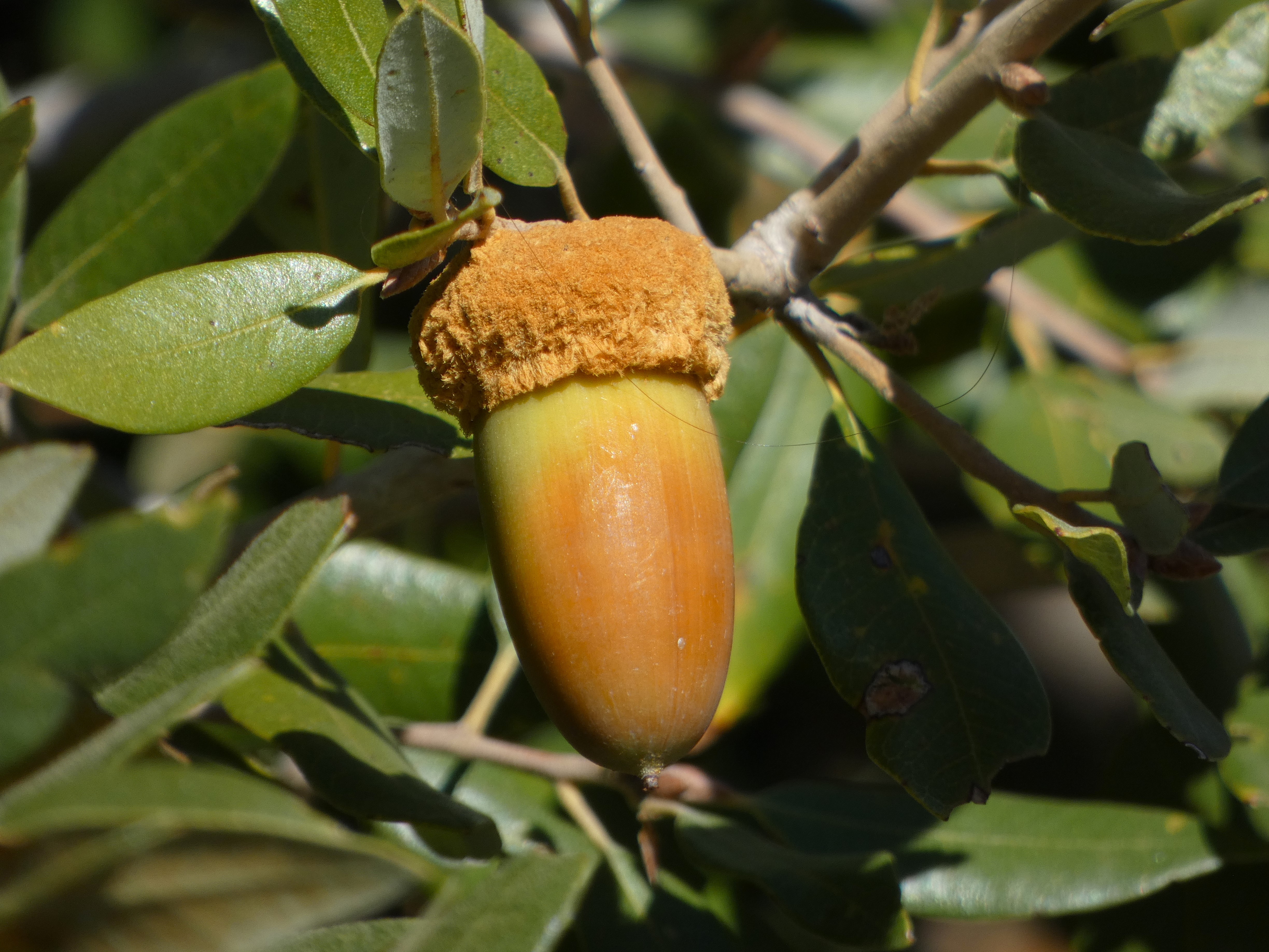
Closer at hand were a lot of ripening acorns. The bears and woodpeckers will be happy.
We reached the valley floor and started our tour of Yosemite's greatest hits. We were surprised to find some wispy curtains of water flowing over Bridalveil Falls. The 620 foot-high waterfall is a classic example of a glacial hanging valley. The main trunk glacier flowing through Yosemite Valley was able to erode a much deeper trough than the small glacier in Bridalveil Creek, so the floor of the creek was left hanging high above the main valley floor.
It was not a cold day, mostly in the sixties, but the sun was intense. It brought out what colors there were in the oaks and dogwood trees.
We didn't see a great many varieties of birds, but there were some Acorn Woodpeckers busy collecting acorns and hiding them in tree "granaries". Such trees can have tens of thousands of drilled holes that can hold a single acorn each. The birds live in loose family groups who search for and guard their food supplies.
Yosemite Valley is not a 'typical' glacially-carved valley. Most such valleys have a U-shaped profile, and are relatively straight. Yosemite Valley is characterized instead by bold cliffs that extend out into the valley with dark recesses in-between. This is the result of having eight distinct intrusions of granitic rock, ranging in composition from 'true' granite to granodiorite, tonalite, and diorite. They differ from each other in the proportions of the minerals quartz, potassium feldspar, and plagioclase. They also vary in the amount of dark minerals they contain including biotite mica, hornblende, and a little augite. They also vary in their pattern of fracturing (jointing), and this is expressed in differing vulnerability to erosion by ice, water, and mass wasting (landsliding and rock falls).
Sentinel Dome (above) is a good example. It is composed of fairly resistant Sentinel granodiorite, but it is jointed and thus forms a somewhat narrow high cliff that looms over the valley.
Yosemite Point on the other hand is composed mostly of unjointed El Capitan granite and forms a wide bold cliff. Sometimes people sort of 'miss' this incredible cliff because much of the time there is a stunning waterfall pouring off the west flank of the precipice (the dark mark on the left side in the picture below). That waterfall is only fifth or seventh highest waterfall in the world, and is known by the moniker of Yosemite Falls, measuring in at 2,425 feet. It wasn't actually dry today, but one needed binoculars to see the small trickle at the top of the cliff.
The autumn season is one of the best times to view Half Dome from the middle of Sentinel Bridge. The Merced River is flowing at a low ebb and the still waters make for memorable reflections. Half Dome is another example of an unjointed monolith of granitic rock called the Half Dome granodiorite. It is the youngest of the igneous intrusions exposed in the valley, with an age of about 84 million years. The Sentinel granodiorite is about 88 million years, and the El Capitan granite around 103 million years. These dates fall within the Cretaceous period, which means that when these molten masses were intruding the crust, there were dinosaurs wandering the surface four or five miles above. The dinosaurs would have experienced occasional volcanic eruptions when some of the intruding magma escaped to the surface.

In the years since, erosion has removed the miles of overlying rock and dumped it into the Central Valley or the waters off the coast of ancient California. The region seems to have been eroded to a low elevation landscape that was later uplifted to form the modern Sierra Nevada.
We wandered around Cook's Meadow and stopped into the store at Curry Village to replenish my t-shirt collection. The sun was starting to get low, so we made our way west to our favorite evening viewpoint, Valley View.
Valley View is almost a secret to Yosemite visitors because it has a small parking lot (maybe room for ten cars) at a blind curve so that if you are in the right-hand lane you might miss it. Since the road is one-way at that point, you would have to repeat a five mile loop to get back. The small parking lot is a blessing because it limits the size of the crowd. It's a quiet spot to enjoy the fading light on the cliffs of El Capitan and the Cathedral Rocks. The river usually flows slowly here making for memorable reflections of the cliffs above. We enjoyed the few moments of peace, and then headed home.
And that's the way it was today...
 

Wednesday, August 4, 2021

A Different Kind of "Other": Yosemite of the Pandemic

Half Dome from Sentinel Bridge
I've spent a fair amount of time writing about "The Other California", the spectacular places we have in our state that don't tend to show up on postcards. But sometimes there are decent reasons to visit the places that are on the postcards. This is especially true with Yosemite Valley and Yosemite National Park. There are few places on Earth as spectacular as the granite cliffs and towering waterfalls. But summer isn't that time. It's hot and dusty, the waterfalls are dry or nearly so, and the crowds and traffic are...simply awful. It's my least favorite time of year.

But sometimes events conspire. A pandemic continues to rage across the country in large part because a significant proportion of the population refuses to mask up or get a vaccination. As a result, the National Park Service instituted a reservation system at Yosemite National Park, limiting the number of daily visitors. And despite the desperately dry conditions caused by the intense drought, there were a number of monsoon-related thunderstorms in the High Sierra in the last few weeks. Mrs. Geotripper and I decided to give the valley a chance, so I carefully watched the reservation site (recreation.gov) and caught a cancellation. We headed up the hill on Monday. 

The view from Swinging Bridge of Yosemite Falls
It was a different world in Yosemite Valley. Two years ago we paid a visit on Labor Day weekend (our out-of-town visitors couldn't come any other time), and it was absolute mayhem. There was an hour-long wait at the entrance station, and a two-hour long traffic jam that resulted in a single parking spot for the day with no chance for exploration (the trams were stuck in traffic too). But Monday there was no waiting to get into the park, and there were parking spots available everywhere, even the ones usually most impacted, like Swinging Bridge, and Sentinel Bridge. The weather was warm, verging on hot, but the ground was moist, the meadows still green, and Yosemite Falls was flowing. It was the kind of day that every visitor to this beautiful place deserves, and it was the kind of day that had become exceedingly rare in recent years.

There is usually a gaggle of photographers standing on Sentinel Bridge (the top picture) because of the artful possibilities of catching the reflection of Half Dome on the Merced River. We had the bridge to ourselves. Swinging Bridge (which for the record does not swing) was crowded as always, but even there the bridge was empty for a few moments and I was able to score a shot of Yosemite Falls without the aforementioned crowds in the picture.

There are lesser-known viewpoints like the one above of the Cathedral Rocks and Cathedral Spires, and on most days the three parking spots are taken. But once again we had the pullout to ourselves, and got a wonderful view of these cliffs that would qualify for national park status in any other place, but which barely catch the attention of travelers on their way out of the valley.

Another crowded spot on a normal day is Valley View at the west end of the valley. The small parking lot is usually packed, but once again there were spots available. El Capitan (left) and the Cathedral Rocks and the wispy, nearly invisible Bridalveil Falls (right) reflected on a slow-moving stretch of the Merced River.

I was going to write about the need to come to Yosemite on a weekday if at all possible, but it occurs to me that a better discussion is whether to implement a reservation system permanently. The concessionaires and surrounding communities of course depend on as many visitors as possible to thrive and maintain their profit margins. But the quality of the experience of visitors is radically diminished when they spend most of their time waiting in lines and being jostled by crowds on the trams and the trails. People expect that sort of thing at an amusement park, but that's not what our national parks were meant to be. Consider the mission of the parks: to preserve unimpaired the natural and cultural resources and values of the National Park System for the enjoyment, education, and inspiration of this and future generations. That simply doesn't happen in our most popular parks like Yosemite, Zion, Arches, and others that are bursting at the seams with tourists.

Our park system has not expanded with our population, and the budget of the park service is cut seemingly every year. The last administration actually cut the size of a number of precious parks. We need to expand the opportunities of people to experience the parks in the best way possible. 

Tuesday, October 31, 2017

Finding Peace in the Nation's Most Crowded Park: A Walk Through Yosemite Valley

If you've read my previous couple of posts, you know I was in Yosemite Valley over the weekend. I was guiding my students on a field trip up the Merced River and into the park on Saturday, and I came back on Sunday seeking some better pictures of the recent rockfall at El Capitan.
We can't park a big bus just anywhere on the floor of Yosemite Valley, so I had to let my students loose to find their way to the upper end of the valley using the free trams. There was enough time that I decided to walk the three or so miles from Yosemite Lodge to Happy Isles, picking whatever winding combination of roads, trails, or sandy river shoreline I could find (there's a direct route, but why stick to that?). I was almost immediately awarded with a nice view of Yosemite Falls, which at 2,425 feet is about the seventh highest waterfall in the world. To my surprise, there was a bit of water flowing, kind of unusual this late in the fall.
The fall colors may not match the technicolor splendor that happens in the hardwood forests of the eastern U.S., but then those forests don't have the backdrop of vertical granite walls that Yosemite has. I was reveling in the splash of color here and there. I often think that fall is my favorite time of year here.

I made my way across the meadow trail to Sentinel Bridge. The cliffs of Glacier Point loomed high above. I didn't realize that I'd be up there looking down the very next day (that will be another post).
Half Dome seems to loom over every meadow view in the valley. It rises 4,800 feet above the valley floor. Although glacial ice filled the valley to the rim, Half Dome stood above the frozen rivers. It was shaped by exfoliation sheeting (corners and edges snapping off), as well as a bit of undercutting from the glaciers below. As you will see in a near future post, Half Dome would better be called Four-fifths Dome, but that doesn't flow so well. Actually I prefer the Native American name of Tis-sa-ack ("Crying Girl").
Because people tend to stare at Yosemite Falls when they are flowing, they find it easy to miss the prominent cliff of Yosemite Point and the Castle Cliffs (below).
I crossed the Merced River at Sentinel Bridge, and got a colorful version of the iconic view of Tis-sa-ack reflected in the still water.
It's the funniest thing...the seven square miles of the floor of Yosemite Valley may very well be the most crowded real estate in the national park system. The park doesn't get the highest number of visitors in the system, but it does get five million, and something like 90% of them spend their visit in the valley. And yet, despite the crowds on the day I was there, the moment I got off the road, I invariably found myself alone. Finding peace in the middle of tourist chaos is a precious gift, and I soaked it in.
Approaching the footbridge near the empty Curry Housekeeping Camp, I had a fine view towards Yosemite Point and the Castle Cliffs reflected on the Merced River.
I quickly walked through the gaggle of people at the stores in Curry Village (I'm not a purist; I stopped for a Gatorade at the store). I headed up the trail to Happy Isles. I started to find more and more Dogwood trees turning shades of pink and yellow. I made it to the Nature Center and met with my students to talk about geology, and then we made our way back to Yosemite Lodge.
While I was talking to the students one last time, I happened to turn and saw the Moon rising along the cliffs off to the southeast. I snapped some zoomed pictures, only to find later that I was aiming directly at Glacier Point. If you look closely, you can see the fencing and people gathered on the edge of the precipice. I was pleased with the effect.

We got on the bus and headed home, and despite the hubbub of running around with students all day, it was one of the most serene experiences I've had in a while. And best of all, I would be up there again the next day!

Sunday, October 27, 2013

The Way it Was Yesterday: Yosemite Valley in Autumn

One of my greatest pleasures is the opportunity that I have of living only a two hour drive from Yosemite Valley. Many places in the world are on my bucket list, and I've managed to see a lot of them over the years, but for many of them the visit is short and will probably happen only once in my life. At Yosemite, I get the chance to explore and revisit places throughout the year. I joke sometimes that my favorite time of the year in Yosemite is the time that I happen to be there, but autumn is truly special.
Yosemite may not have millions of acres of deciduous forests like those in the eastern United States (and the fall colors of such places are on my bucket list), but the valley offers plenty of colorful trees and shrubs with gigantic cliffs as a backdrop, and the calm still pools of the Merced River as a reflecting mirror.
As I mentioned in the previous post, we discovered a nice little spot on the Merced River across from the sheer cliff of El Capitan. I don't think I've captured it before mirrored in the river as it is in the photos above.
 We moved up the road a bit to the Swinging Bridge Parking Lot, which was full of people as usual, but it wasn't hard to wander across the bridge and leave most of them behind. Above is a shot of Yosemite Falls (minus the water, of course) with the Merced River in the foreground.
Behind me on the southwest side of the valley were the cliffs of Taft Point and Sentinel Rock. The rocks are rugged and amazingly steep, but sometimes receive a bit less attention with Yosemite Falls just across the river.
Half Dome wasn't yet visible, but we could see the high peak of Clouds Rest at the upper end of the valley, along with Washington Column and the steep cliffs below Half Dome.
To the west were the cliffs of the Three Brothers. The largest rockfall in modern times thundered off the cliffs there in 1987, when 600,000 cubic yards fell onto the valley floor. No one was injured, but the road was blocked for a while. If you want to know a bit more about this rockfall and others, check out my roadside guide to the geology of Yosemite Valley over at Geotripper Images.
Looming high above Swinging Bridge is the towering spire of Sentinel Rock. It's not so easy to climb, but Sentinel Dome lies behind it, and is accessible by an easy trail from the Glacier Point Road. I recommend it, but I have a feeling that with the first substantial storm coming in tomorrow or Tuesday, you might have to wait until next summer to check it out!
Our next stop was Sentinel Bridge for one of the most iconic views of Half Dome. Autumn is one of the best times of the year for photographs as the river is low and calm, providing wonderful reflections. Sometimes, though, I just don't get the moronic things that people do. I cropped it out, but someone had tied a swing rope to a tree on the left side of the river. I tried to pull it down, but couldn't, so there it remains. I'll see if someone removes it before next week when I come up with the students from my Earth Science course.

The other side of the bridge offers a nice view down the valley towards Yosemite Falls, and on that side another idiot had strung a rope across the river, and was trying to cross the river in a hammock kind of thing. He was having problems with his contraption, and I am glad to report that he sploshed into the river. I would have liked it even more if a ranger had happened by and ticketed him for something or another. Recreation is great, but don't do it in front of the most iconic picture spots in the valley (I'm reminded of the selfish people who linger in Delicate Arch in Arches National Park just as the sun is setting and dozens of people are trying to photograph the span without people mugging for cameras in the middle of it).
 Our last stop before leaving was in the meadow next to the Ahwahnee Hotel. The view is towards Happy Isles and Glacier Point. The day was every bit as peaceful as it looks, and the vast majority of people that I saw there were clearly loving the view. Everyone seemed just a bit quieter and introspective than the boisterous crowds I experience in the summertime.
 It was a beautiful day in one of my favorite places during my favorite times of the year!