Showing posts with label Merced River. Show all posts

Monday, March 14, 2022

The Merced River of California: A Place for Wildflowers and Landslides (and Yosemite Valley)

The Merced River is one of California's extraordinary waterways. First and foremost, it is the river that carved Yosemite Valley, which is one of the world's most spectacular valleys. You may be forgiven for thinking that glaciers carved Yosemite Valley, and they certainly had an important role, but it was learned years ago that the heavy-duty work of carving the 3,000-foot-deep gorge was done before the ice ages ever arrived 2 million years ago. The glaciers certainly modified the shape of the valley, but the depth was first achieved by water flowing over stone.

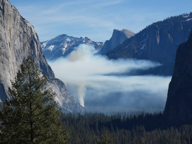
We spent a couple of days in the valley at a time when the crowds are few, the snow is in retreat, but the green of spring is still some weeks away. It was neither winter nor spring, but the waterfalls were full and the birds were becoming more active, and we had a marvelous time. This morning brought a sight we had never seen in dozens of previous visits though: the beginning of a controlled burn. 

The native Americans who first lived and hunted in the valley knew the value of fire. They would regularly set fires to the forest and meadows to clear out undergrowth and maintain the extensive meadows on the valley floor. When the park was established in 1890, fire became the enemy and any hint of a fire was quickly put out. As a consequence the meadows shrank from the original 750 acres to less than 100 today. The forest became choked with young trees, and fuel built up on the forest floor. It was a major disaster-in-waiting. In recent years, the park management has sought to return the valley floor to something resembling the environment that existed prior to European colonization. Some of the activity has involved some controversial logging operations, and the controlled burns can interfere with the experience of visitors, but the eventual changes will be a vast improvement over present conditions.
One of our real motivations for the trip actually involved a different part of the Merced River, the deep canyon downstream of Yosemite Valley. The Merced River canyon downstream of the lowest extent of the glaciers is a different place entirely. The vertical walls of glacially-shaped granite give way to a V-shaped river valley covered by vegetation that often obscures an extensive belt of metamorphic rocks that are hundreds of millions years older than the granite intrusions.
While not as "spectacular" as Yosemite Valley, the canyon is not without scenic wonders. Indeed, for a few weeks in the spring the walls of the canyon can explode into a color palette that puts the gray granite cliffs of Yosemite Valley to shame. Wildflowers like golden poppy, lupine, and fiddleneck and many others can cover the slopes from the river to the canyon rim.
The climax (if it comes; it's been a dry year) lies a few weeks in the future. But here and there, the slopes provided a hint of what is to come.
The redbuds are just getting started with their not-red buds. More of a pink/purple shade if you ask me.
The slopes of the gorge are also an environment adapted to fire. In the Mediterranean climate the winters are cool and wet, and the summers are very hot and dry. Fires have always swept through the gorge, but those of recent years have been particularly intense due to the extended droughts and higher temperatures due to global warming.
Ultimately fires are a necessary part of the environment, but they can seem particularly tragic in the short-term, especially when people are killed or developments destroyed. The wildflowers play an important role in the recovery of the slopes, as they are pioneer species that help rebuild nutrients in the soils that can assist in the return of the shrublands and forest. The seed may lie in the soil for years before conditions are right for germination, and then the barren slopes come alive with color.
The Golden Poppy is a particularly visible part of the wildflower population. It is California's state flower, and it was a great choice because it thrives in many if not most of California's diverse ecosystems. They're common in the Coast Ranges, the Great Valley, the Sierra Nevada foothills, the volcanic landscapes of the Cascades and Modoc Plateau, the mountains of southern California, and in the Mojave Desert (the Antelope Valley Poppy Reserve is spectacular right now, from what I am hearing). They can also grow on California's strange serpentine soils that most plants cannot tolerate.
A final sight were looking for was the Ferguson Slide. The slope at this particular turn in the river was always unstable, but in 2006 the entire slope slide downwards and covered the highway with tens of thousands of cubic yards of boulders. Far more debris remains on the slopes above, and for a time there were fears that a truly massive slide could block the river and form a natural dam with a lake several miles long. A number of "fixes" were considered, and in the meantime "temporary" bridges were built to provide one-way access on the busy highway. Temporary in the sense that they have been there for fifteen years and counting.
In the end they have decided to build an "avalanche shed", but for rocks instead of snow. The cost is in excess of $180 million (which at the time was about the entire budget for Yosemite National Park). Nature doesn't take kindly to attempts at altering the physics of the slope, and some of the first attempts at stabilizing the upper slopes were laughably sloughed off. There was an earlier coating of the fencing material that was destroyed soon after application. They spent several years carting off nearly 150,000 cubic yards of metamorphic rock and have again tried to fence in the slope. It will be interesting to see what happens when the construction of the shed actually begins.
The photo above is the most comprehensive picture I've been able to capture. I made sure to be last in line when the traffic light changed and allowed the line of cars to follow the one-lane road. I lingered a few seconds to get the shot, and hurried along to make sure I didn't run into oncoming traffic on the narrow bridge. 

There are many more stories to tell of the Merced River downstream, where it flows through the Mother Lode, the places where it lies trapped in the waters of Lake McClure and Lake McSwain, the dredge pits at Merced Falls, and the slow journey across the floor of the Great Valley where it ends in the San Joaquin River. Those will come another day!

Friday, May 7, 2021

Went Looking for Rocks and Birds, Came Back With Flowers and Butterflies

Oh boy, do I ever have a blind spot for learning. I can't learn flowers or butterflies. I'd blame it on age, but I've managed to learn something like 200 bird names in the last three years, so it's not that. Whatever the cause, I headed into the hills of the Sierra Nevada today looking for rocks and birds, but I came home with a bunch of flower pictures with butterflies that I couldn't confidently identify. So I won't try...I'll depend on your help! The comments section is below.
We were headed to Yosemite Valley to see the waterfalls before they dried up (it has been an excruciatingly dry year). We had already missed what was apparently a spectacular Golden Poppy extravaganza in the Merced River canyon downstream of Yosemite, but there were still plenty of wildflowers to be seen, especially on the shady north-facing slopes. But the unexpected delight of the day was the abundance of butterflies on what flowers there were.
One poor individual flew into our car and had a confusing time trying to get nectar from a pillow.
There was even bits of drama with butterflies vying for the best flowers. The one in the pictures above and below drove off several Checkerspots.
I guess if I get tired of trying to identify every bird I see, I'll turn to flowers and butterflies. The thing is, birds are a year-round project. The flowers are ephemeral, and so are the organisms that feed off of them.
There weren't just butterflies in the wildflower fields. I caught the Ladybug below too, and any number of bees and flies.
It was a spectacular day, and not just from the flowers. Look for some new posts on Yosemite Valley as soon as I get the chance!
 

Thursday, April 25, 2019

Tales From the Semi-Super-Bloom Tour, Part 3: On the Road to Yosemite

Mrs. Geotripper and I didn't see the legendary "Super-Bloom" in Southern California. We didn't have the time or patience to deal with the crowds and trampling and helicopter landings in fields of flowers. We instead set out to find the evidence of spring in some less heralded and less crowded places that were perhaps not in a state of a once-in-a-decade superbloom, but showed some delightful color nonetheless. At the end of March it was the Mojave Desert and Death Valley National Park. Then a week ago we headed up to Yosemite Valley.
Yosemite Valley is just coming out of the throes of winter, so we weren't expecting any flowers there, and as such we were not disappointed. But our journey from the floor of the Great Valley and through the Merced River Valley provided us with an explosion of color. The prairies east of Merced and Planada were rich with Blue Dicks.
We climbed into the foothills and made a brief stop in Midpines where we saw these Baby Blue Eyes (above), and blooming Redbuds that aren't exactly really red.
Our road dropped into the canyon of the Merced River, and we followed the swollen river upstream. As we approached the village of El Portal, the flowers grew thick along the slopes. Golden Poppies were common, offset against the somber metamorphic rocks of the Shoofly Complex.
I've seen Golden Poppies growing in a wide variety of habitats throughout California, from high mountain slopes to deep forests to desert plains. No wonder they were declared our state flower.
We turned a corner and were greeted by slopes covered with purple lupines and Golden Poppies.
It's not a "super-bloom", it's merely a drought-free spring. But spring in the Merced River canyon is a colorful affair. It's a privilege to live close enough to see these beautiful slopes.

Thursday, April 12, 2018

After the Deluge: Yosemite Valley a Day Later (and a sight I've never seen in more than 100 visits)

Yosemite National Park is a treasure. And the gem of the park is Yosemite Valley. There are spectacular spots to visit throughout the park and region, but ultimately, the sheer granite walls and booming waterfalls are the heart of this part of the Sierra Nevada. Most people know this of course, and the valley struggles with the desires of millions of people who wish to see the park for themselves. There are horror stories of absolute gridlock throughout the valley, with upset families who wait for hours just to get into the park, and then never find a place to park and get to know it better. I can barely imagine the frustration of devoting a hard-earned vacation to see the place and then have it spoiled by the chaos of too many people.
Bridalveil Fall (620 feet) and the Leaning Tower at the west end of the valley
I've been privileged to live relatively close to the park, and in 30 years, I've been there over a hundred times. I've quite literally never had a bad time, but part of the reason is that I've been able to pick and choose the times I visited. It turns out that the time most people set aside for vacation, in July or August, is possibly the least interesting time to do so. It's still spectacular, but the crowds are the worst, the waterfalls mostly dry, and it's hot. In fall, the valley is quieter, and the oaks and dogwoods add a splash of color. Winter brings snow and silence. Spring is noisy because of the waterfalls booming from the canyon rim. If your schedule allows, go there in the off season!
Ribbon Falls only flows in the spring; it's the highest free-falling waterfall in the park at 1,612 feet.
Of course, if you come at another time of year, you would be taking a chance with the weather. That's what happened to me last week. I was scheduled to take my students there on Saturday, but fate intervened with an epic warm tropical storm that dumped inches of rain on the snowpack. The Merced River swelled to nearly 14 feet (10 is official flood level) and major roads in the valley were under a few feet of water. For one of very few times in its history, the park was closed as a precaution and people were evacuated. I was luckily able to reschedule for Sunday, because the sun came up in a cloudless sky and the difference between the two days was astounding.
Upper Yosemite Falls, 1,430 feet high, the second highest in the park after Ribbon Falls (above).
I included some direct comparisons between Saturday and Sunday in my previous post (with thanks to the Park Service for posting pictures of the storm). Today I am offering views of some of the classic views in the park, revealing the vast amounts of water still flowing into and through the valley. The Merced River had subsided somewhat but was still flowing at flood level, but only barely. The main effect was the low-lying valley meadows that were still underwater (the next two pictures).
A flooded Cook's Meadow forms the foreground for Upper Yosemite Falls.
The occasional flooding of the meadows is part of what maintains the meadows as open areas. Tree saplings are smothered underwater, and only grasses and sedges that can survive the high water table. Not all of the meadows have survived however. Since the park was established, some of the original meadows have progressed into thick forest...there are only about 65 acres of meadows left out of the original 745 acres that existed at the time of European discovery. The growth of the forest is largely the result of fire suppression. The park service will occasional burn some of the meadow margins on purpose to help maintain the integrity of the open spaces.
No visit to Yosemite Valley would seem complete without a view of Half Dome, but I have been there a fair number of times when my students never had a chance to see it. When rain is falling, it can be completely hidden in the clouds. But on Sunday it was there in all its glory. The unique shape is due to a combination of exfoliation (the fracturing of rocks parallel to the surface, and jointing, which is the result of expansion as the rock is exposed at the surface. Exfoliation, which tends to remove corners and edges, leads to the rounding of the rock into the dome shape. But a prominent joint crossed the dome, and glacial quarrying at the base caused the rock on one side of the joint to be eroded away, forming the prominent cliff, or face, of Half Dome. When seen from other angles, it is clear that Half Dome should have been called Four-fifths Dome...
Directly across from Half Dome are North Dome and the Washington Column (below). The Royal Arches, in the center-left of the picture, are the result of a sort of reverse exfoliation, where the rock snapped out and fell from the middle of the arch, instead of the overlying cliff.
At the end of our day, we made a final stop at Valley View, one of the unheralded pullouts (only eight parking spaces) with one of the finest views to be had in all the valley (which is maybe why they call it "Valley View"). El Capitan, the sheer 3,000 feet cliff, looms on the left, while the Cathedral Rocks and Bridalveil Falls dominate the right side of the valley. A swollen flooded Merced River fills the foreground, with Bridalveil Meadow just across the raging waters. Only one of the ice age glaciers made it past this point, the so-called Pre-Tahoe (or Sherwin) Glaciation that took place around 800,000 years ago. The subsequent Tahoe and Tioga glaciers only reached the base of El Capitan and Cathedral Rocks. The Pre-Tahoe Glaciation probably did the most work in shaping the valley we see today.
I promised in the title of the post that we would include a sight I have never seen in more than 100 visits to the valley. We arrived that day when the gates to the valley reopened, at noon. A great many other people arrived at the same time, and for the first two hours the valley felt crowded. But by 4 PM, most of the visitors were already on their way back home, and the parking lots were practically empty. That is a sight in itself. But it was the drive out that astounded me.  Every time I visit the valley, Northside Drive from Curry Village to the Visitor Center area is always full of cars. Always.
But these two pictures show the astounding sight...not a single car ahead of us or behind us. For a few precious moments, we had the valley to ourselves. It's something I've never seen before, ever.

There's a secret though...even on the most crowded days in Yosemite Valley, you can find peace, serenity, and quiet. It requires that you park the car and get out. Not every trail is crowded, and in some places you can make your own path through the forest. The number of fellow hikers decreases exponentially with the distance from any paved road. If you are ever given a precious few moments in this grandest of valleys, give it a try. You won't regret it.
And that's the way it was, after the deluge...

Saturday, April 7, 2018

Liveblogging the Deluge: Merced River in Yosemite Reaches Flood Stage

This picture is a cheat. I'm not in Yosemite, this picture is from two years ago
I was supposed to be in Yosemite right now. We had scheduled a field studies class today that would have sent us up the Merced River to Yosemite Valley and back, but nature has intruded with an unusual April atmospheric river storm that is setting some daily rainfall records across Central California. San Francisco, for instance, received rain equivalent to an average April in a single day. My backyard rain gauge in the Central Valley has recorded 2.2 inches since yesterday. In 26 years of measuring, there have only been three Aprils where we've received that much in the entire month.

I had already decided to postpone the trip by last Monday when the forecasts called for flooding on the Merced River in Yosemite Valley. In short, the river jumps its banks at the 10 foot level (about 6,000 cubic feet per second). At 12 feet (9,500 cfs), the flooding river covers some of the main roads in the valley. Today's storm is expected to result in a river that crests at 14 feet, or 14,000 cubic feet per second. Even if I had decided to go ahead with the field trip, we would not have reached our goal, because the park service closed Yosemite Valley yesterday. We're going to try and make the trip tomorrow to check out any flood damage, but if the valley floor is still closed, we'll try to see Hetch Hetchy instead.
Yosemite Valley is especially prone to flooding because it is high up in the mountains close to the headwaters of the Merced River, and when rain falls, it falls on mostly barren granite. The water flows into channels very quickly, and the channels gather into the Merced River and Tenaya Creek just as quickly. There are no reservoirs upstream for flood control (nor should there ever be).

If it drives home the point, Yosemite Valley has only been closed a few times in its history, most notably in 1997 during the unprecedented floods of that year, and during a few government shutdowns. It takes a major event to convince the park administration to shut down the iconic valley.

I hope to be back tomorrow with pictures of Yosemite Valley. We'll see what happens! I will update the flood hydrograph in the space below when the river flow peaks.

UPDATE: At 1:00 PM, the river has reached 10,800 cubic feet per second (12.85 feet). If I'm reading the data right (below), this is only the fourth time the flow has reached this level since 1996.

Here is the 1:00 PM report:

Also, here is a link to video of the main road in Yosemite Valley at the moment, courtesy of the Fresno Bee.

UPDATE 2: We've reached 12,100 cubic feet per second as of 5:00PM, and 13.68 feet (10 feet is flood  level), and the flood may be peaking. The discharge only increased by 100 cfs in the last hour.

FINAL UPDATE: It looks like the flood has peaked at 12,100 cfs, as it has been there for two hours. I expect it will now start dropping. I'm hoping the valley will reopen in time for our visit tomorrow. If not, I guess we'll check out Hetch Hetchy!

WELL, OKAY, ONE MORE UPDATE: Yosemite National Park has posted pictures of the flooding today: https://www.facebook.com/pg/YosemiteNPS/photos/?tab=album&album_id=1650167855031490

Tuesday, October 31, 2017

Finding Peace in the Nation's Most Crowded Park: A Walk Through Yosemite Valley

If you've read my previous couple of posts, you know I was in Yosemite Valley over the weekend. I was guiding my students on a field trip up the Merced River and into the park on Saturday, and I came back on Sunday seeking some better pictures of the recent rockfall at El Capitan.
We can't park a big bus just anywhere on the floor of Yosemite Valley, so I had to let my students loose to find their way to the upper end of the valley using the free trams. There was enough time that I decided to walk the three or so miles from Yosemite Lodge to Happy Isles, picking whatever winding combination of roads, trails, or sandy river shoreline I could find (there's a direct route, but why stick to that?). I was almost immediately awarded with a nice view of Yosemite Falls, which at 2,425 feet is about the seventh highest waterfall in the world. To my surprise, there was a bit of water flowing, kind of unusual this late in the fall.
The fall colors may not match the technicolor splendor that happens in the hardwood forests of the eastern U.S., but then those forests don't have the backdrop of vertical granite walls that Yosemite has. I was reveling in the splash of color here and there. I often think that fall is my favorite time of year here.

I made my way across the meadow trail to Sentinel Bridge. The cliffs of Glacier Point loomed high above. I didn't realize that I'd be up there looking down the very next day (that will be another post).
Half Dome seems to loom over every meadow view in the valley. It rises 4,800 feet above the valley floor. Although glacial ice filled the valley to the rim, Half Dome stood above the frozen rivers. It was shaped by exfoliation sheeting (corners and edges snapping off), as well as a bit of undercutting from the glaciers below. As you will see in a near future post, Half Dome would better be called Four-fifths Dome, but that doesn't flow so well. Actually I prefer the Native American name of Tis-sa-ack ("Crying Girl").
Because people tend to stare at Yosemite Falls when they are flowing, they find it easy to miss the prominent cliff of Yosemite Point and the Castle Cliffs (below).
I crossed the Merced River at Sentinel Bridge, and got a colorful version of the iconic view of Tis-sa-ack reflected in the still water.
It's the funniest thing...the seven square miles of the floor of Yosemite Valley may very well be the most crowded real estate in the national park system. The park doesn't get the highest number of visitors in the system, but it does get five million, and something like 90% of them spend their visit in the valley. And yet, despite the crowds on the day I was there, the moment I got off the road, I invariably found myself alone. Finding peace in the middle of tourist chaos is a precious gift, and I soaked it in.
Approaching the footbridge near the empty Curry Housekeeping Camp, I had a fine view towards Yosemite Point and the Castle Cliffs reflected on the Merced River.
I quickly walked through the gaggle of people at the stores in Curry Village (I'm not a purist; I stopped for a Gatorade at the store). I headed up the trail to Happy Isles. I started to find more and more Dogwood trees turning shades of pink and yellow. I made it to the Nature Center and met with my students to talk about geology, and then we made our way back to Yosemite Lodge.
While I was talking to the students one last time, I happened to turn and saw the Moon rising along the cliffs off to the southeast. I snapped some zoomed pictures, only to find later that I was aiming directly at Glacier Point. If you look closely, you can see the fencing and people gathered on the edge of the precipice. I was pleased with the effect.

We got on the bus and headed home, and despite the hubbub of running around with students all day, it was one of the most serene experiences I've had in a while. And best of all, I would be up there again the next day!