Showing posts with label Sierra Nevada wildflowers. Show all posts

Monday, March 14, 2022

The Merced River of California: A Place for Wildflowers and Landslides (and Yosemite Valley)

The Merced River is one of California's extraordinary waterways. First and foremost, it is the river that carved Yosemite Valley, which is one of the world's most spectacular valleys. You may be forgiven for thinking that glaciers carved Yosemite Valley, and they certainly had an important role, but it was learned years ago that the heavy-duty work of carving the 3,000-foot-deep gorge was done before the ice ages ever arrived 2 million years ago. The glaciers certainly modified the shape of the valley, but the depth was first achieved by water flowing over stone.

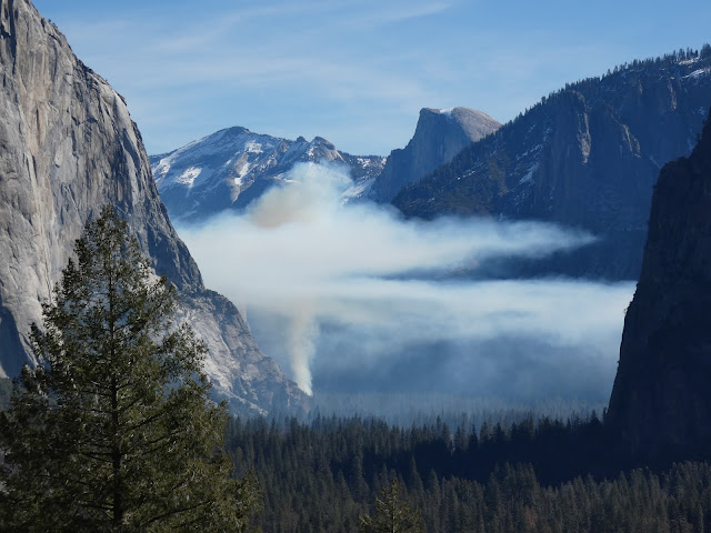
We spent a couple of days in the valley at a time when the crowds are few, the snow is in retreat, but the green of spring is still some weeks away. It was neither winter nor spring, but the waterfalls were full and the birds were becoming more active, and we had a marvelous time. This morning brought a sight we had never seen in dozens of previous visits though: the beginning of a controlled burn. 

The native Americans who first lived and hunted in the valley knew the value of fire. They would regularly set fires to the forest and meadows to clear out undergrowth and maintain the extensive meadows on the valley floor. When the park was established in 1890, fire became the enemy and any hint of a fire was quickly put out. As a consequence the meadows shrank from the original 750 acres to less than 100 today. The forest became choked with young trees, and fuel built up on the forest floor. It was a major disaster-in-waiting. In recent years, the park management has sought to return the valley floor to something resembling the environment that existed prior to European colonization. Some of the activity has involved some controversial logging operations, and the controlled burns can interfere with the experience of visitors, but the eventual changes will be a vast improvement over present conditions.
One of our real motivations for the trip actually involved a different part of the Merced River, the deep canyon downstream of Yosemite Valley. The Merced River canyon downstream of the lowest extent of the glaciers is a different place entirely. The vertical walls of glacially-shaped granite give way to a V-shaped river valley covered by vegetation that often obscures an extensive belt of metamorphic rocks that are hundreds of millions years older than the granite intrusions.
While not as "spectacular" as Yosemite Valley, the canyon is not without scenic wonders. Indeed, for a few weeks in the spring the walls of the canyon can explode into a color palette that puts the gray granite cliffs of Yosemite Valley to shame. Wildflowers like golden poppy, lupine, and fiddleneck and many others can cover the slopes from the river to the canyon rim.
The climax (if it comes; it's been a dry year) lies a few weeks in the future. But here and there, the slopes provided a hint of what is to come.
The redbuds are just getting started with their not-red buds. More of a pink/purple shade if you ask me.
The slopes of the gorge are also an environment adapted to fire. In the Mediterranean climate the winters are cool and wet, and the summers are very hot and dry. Fires have always swept through the gorge, but those of recent years have been particularly intense due to the extended droughts and higher temperatures due to global warming.
Ultimately fires are a necessary part of the environment, but they can seem particularly tragic in the short-term, especially when people are killed or developments destroyed. The wildflowers play an important role in the recovery of the slopes, as they are pioneer species that help rebuild nutrients in the soils that can assist in the return of the shrublands and forest. The seed may lie in the soil for years before conditions are right for germination, and then the barren slopes come alive with color.
The Golden Poppy is a particularly visible part of the wildflower population. It is California's state flower, and it was a great choice because it thrives in many if not most of California's diverse ecosystems. They're common in the Coast Ranges, the Great Valley, the Sierra Nevada foothills, the volcanic landscapes of the Cascades and Modoc Plateau, the mountains of southern California, and in the Mojave Desert (the Antelope Valley Poppy Reserve is spectacular right now, from what I am hearing). They can also grow on California's strange serpentine soils that most plants cannot tolerate.
A final sight were looking for was the Ferguson Slide. The slope at this particular turn in the river was always unstable, but in 2006 the entire slope slide downwards and covered the highway with tens of thousands of cubic yards of boulders. Far more debris remains on the slopes above, and for a time there were fears that a truly massive slide could block the river and form a natural dam with a lake several miles long. A number of "fixes" were considered, and in the meantime "temporary" bridges were built to provide one-way access on the busy highway. Temporary in the sense that they have been there for fifteen years and counting.
In the end they have decided to build an "avalanche shed", but for rocks instead of snow. The cost is in excess of $180 million (which at the time was about the entire budget for Yosemite National Park). Nature doesn't take kindly to attempts at altering the physics of the slope, and some of the first attempts at stabilizing the upper slopes were laughably sloughed off. There was an earlier coating of the fencing material that was destroyed soon after application. They spent several years carting off nearly 150,000 cubic yards of metamorphic rock and have again tried to fence in the slope. It will be interesting to see what happens when the construction of the shed actually begins.
The photo above is the most comprehensive picture I've been able to capture. I made sure to be last in line when the traffic light changed and allowed the line of cars to follow the one-lane road. I lingered a few seconds to get the shot, and hurried along to make sure I didn't run into oncoming traffic on the narrow bridge. 

There are many more stories to tell of the Merced River downstream, where it flows through the Mother Lode, the places where it lies trapped in the waters of Lake McClure and Lake McSwain, the dredge pits at Merced Falls, and the slow journey across the floor of the Great Valley where it ends in the San Joaquin River. Those will come another day!

Friday, May 7, 2021

Went Looking for Rocks and Birds, Came Back With Flowers and Butterflies

Oh boy, do I ever have a blind spot for learning. I can't learn flowers or butterflies. I'd blame it on age, but I've managed to learn something like 200 bird names in the last three years, so it's not that. Whatever the cause, I headed into the hills of the Sierra Nevada today looking for rocks and birds, but I came home with a bunch of flower pictures with butterflies that I couldn't confidently identify. So I won't try...I'll depend on your help! The comments section is below.
We were headed to Yosemite Valley to see the waterfalls before they dried up (it has been an excruciatingly dry year). We had already missed what was apparently a spectacular Golden Poppy extravaganza in the Merced River canyon downstream of Yosemite, but there were still plenty of wildflowers to be seen, especially on the shady north-facing slopes. But the unexpected delight of the day was the abundance of butterflies on what flowers there were.
One poor individual flew into our car and had a confusing time trying to get nectar from a pillow.
There was even bits of drama with butterflies vying for the best flowers. The one in the pictures above and below drove off several Checkerspots.
I guess if I get tired of trying to identify every bird I see, I'll turn to flowers and butterflies. The thing is, birds are a year-round project. The flowers are ephemeral, and so are the organisms that feed off of them.
There weren't just butterflies in the wildflower fields. I caught the Ladybug below too, and any number of bees and flies.
It was a spectacular day, and not just from the flowers. Look for some new posts on Yosemite Valley as soon as I get the chance!
 

Sunday, March 19, 2017

Spring is Coming, and Flowers are Awakening in the Sierra Nevada Mother Lode

It's still a bit early to see the awesomeness to come, but the spring wildflowers are beginning to make a splash of color in the Sierra Mother Lode. With the record and near record amounts of rain in Northern California, the slopes are primed to produce a wildflower show to compete with the "super-blooms" taking place in the California deserts this year. We were exploring a portion of the southern Mother Lode in the vicinity of Mariposa and Coulterville yesterday, and I took my attention off the rocks for a few moments to catch some pictures of the early-blooming flowers. Above is a Fiddleneck (Amsinckia species), often one of the first of the wildflowers to bloom in this region. It can be poisonous to livestock, and yet was used as a food and medicine source by Native Americans.
Near the Pinetree-Josephine Mine we saw a number of Brodiaea, or Blue Dicks (Dichelostemma capitatum). These beautiful flowers grow from bulbs that were also an important source of food to the Native Americans of this region.
I don't know as many wildflower species as I should, as much as I appreciate their beauty. In a few places there were carpets of small yellow flowers (Goldfields, in the Lasthenia genus, thanks to Siera Nystrom in the comments).
Seeing some of the flowers growing in the usually poisonous serpentine soils reminded me that it is time to head up to the Red Hills soon, a Mother Lode locality known for a large number of endemic species.
As per Jane Strong in the comments, Orobanche fasciculata, clustered broomrape. Thanks for the identification!
And finally, the ever-present and always beautiful Indian Paintbrush (Castilleja species). There are some 200 species of this flower.

This is only the very beginning of what promises to be a wonderful year for wildflowers. I hope to be bringing many more such scenes to your attention in coming weeks!

Sunday, April 10, 2016

Flowers, Folds, and Floods on the Way to Yosemite

So this thing happened yesterday. California, despite near-normal amounts of precipitation this year, is still in the grip of a long-term drought. The first part of March was wet, but for the last three weeks the rain ceased entirely, like someone turned off the tap. Then a low pressure system parked itself  right on top of my town and the swirling air mass dropped around two inches of rain onto the region between Yosemite National Park and Modesto-Turlock. Our Great Valley towns had the unusual distinction of being pretty much the wettest places in the entire state.
That being the case, I had a field studies class scheduled yesterday to Yosemite Valley. The weather forecasts (which had not really predicted the prodigious amounts of rain) suggested that the storm was waning and that we might see some clearing in the afternoon when we arrived at the valley. We have schedules to keep, and timelines to follow, so the trip left as planned. It never stopped raining for a minute that entire trip from start to finish.

Despite the nonstop rain, we accomplished most of our goals, and saw most of the features of Yosemite and the Merced River Canyon (Half Dome was a no-show, though). We managed to thread our way through the day, catching some stops when the rain had declined to a drizzle, or having a sheltered place to discuss the geological features of particular stops.
One of our first stops was on Highway 140 to Mariposa, where we got to see an outcrop of the Mariposa Slate, a former mudstone from the deep ocean floor that had been compressed and baked into a hard sequence of slate and phyllite. The rocks have been uplifted and tilted, but as one can see in the picture above, folded into a series of very tight 'v's. The rocks have been on a long journey, forming on the floor of the Pacific Ocean, and being swept under the North American plate. We are looking at the part of the seafloor that was scraped off and added to the continental edge around 200 million years ago.
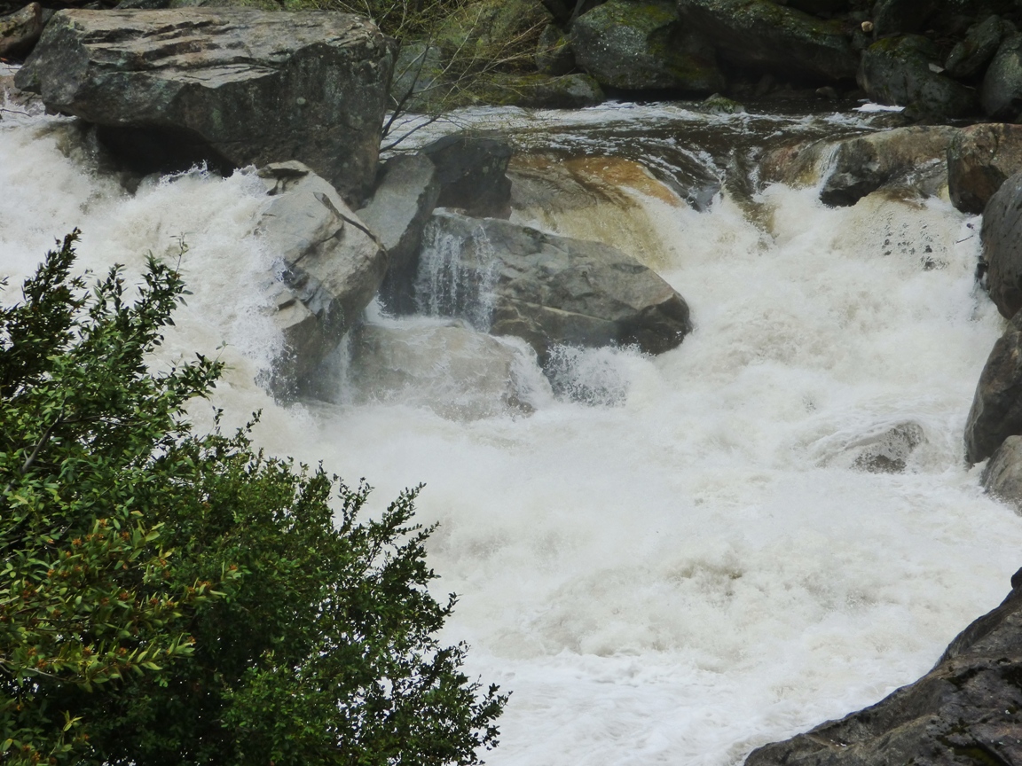
The Merced River was a raging fury. The very warm March and April dry periods were causing an early snowmelt so the river was running high, and the widespread rain added to the runoff. Average flow for early April is around 800 cubic feet per second. The flow of the river yesterday was at least three times average, around 2,800 cfs.

The flow yesterday may have been a record for the date (although I'm not quite clear how to interpret the graph on that count). The river was not actually officially flooding (it would have to reach 6,600 cfs), but flows yesterday were consistent with the peak runoffs that normally occur in late May and early June. The record low flow for the date was just set last year, at 244 cfs. The greatest recorded flood ever occurred during the El Nino year of 1997 when the river reached 24,600 cubic feet per second.
Whether assisted by yesterday's freak rainstorm or not, the high flows are a bit ominous. The future of the Merced River under the most generous of global warming scenarios includes the possibility of more precipitation, but far less snow. That means earlier runoff and less chance to store water in reservoirs because of the necessity to leave room for flooding events.

Saturday, March 21, 2015

Work to Begin on the Ferguson Slide on Yosemite Highway 140


The problem with a lot of beautiful national parks in mountain landscapes is that they lie in mountain landscapes. The rugged terrain is subject to landslides, and my favorite nearby park, Yosemite, is no exception. The park has four entrances, but only one can be considered an "all weather" access point, as it follows the Merced River, and does not have to surmount any snow-covered passes. Highway 140 may be the lower route, but it is not without its problems. The Merced Canyon downstream of Yosemite Valley is rugged and steep, some 2,000 feet deep in places. Instead of granitic rock, it carves through the metamorphic rocks of the Mother Lode, including the sometimes unstable slate, phyllite and chert of the Calaveras Complex.

There was a prehistoric slide near Savage's Trading Post. The so-called Ferguson Slide had caused problems in the past, and Caltrans had been looking to stabilize it, but in 2006 it overwhelmed the mitigation efforts and gave way, covering 600 feet of Highway 140 with hundreds of thousands of tons of metamorphic rock. The highway was totally blocked, and there were serious fears that the slide could completely block the river valley and flood the small village upstream.

Local communities, especially Mariposa, were devastated by the Ferguson Slide. Tourism makes up a huge portion of their economy, and with the highway closed, no one was coming through town. The first temporary fix, two quickly built bridges that detoured around the slide, were impassable to buses. Mariposa continued to suffer economic losses, so by 2008 the bridges were realigned. At present there are are delays of up to 15 minutes waiting for traffic to pass the one-way road.

I missed the story at first in the newspaper last week ("newspaper": a form of information transfer that predates the internet), but work has begun on a "permanent" fix on the section of Highway 140 beneath the slide. The first part will involve the removal of more than 100,000 cubic yards of slide debris, followed by the construction of a 750-foot "rock shed" that will channel future debris slides over and across the highway. I've seen snow sheds before on many alpine passes, but this will be only the second rock shed in the country according to Caltrans. The project will cost $133 million and will be completed in fall 2019. The work is not expected to block traffic, as the "temporary" detour will remain open.

I understand that the rock shed approach will be one of the least environmentally intrusive approaches to mitigating the slide (assuming it's done right), but I'm struck by the fact that this one road repair will be only slightly less expensive than the complete renovation of Yosemite's infrastructure following the devastating floods of 1997 ($182 million in 1997 dollars). And it's been nearly twenty years since those renovations, and Congress has never been one to keep up with the care of our national parks. It would be nice if we could take care of our parks as well as we care for the access to those parks.

In any case, this is a good time to be visiting Yosemite via Highway 140. Despite the drought years, the spacing of the few rainstorms we've had has left a lot of greenery along the river corridor. I haven't been up there yet to check, but I'll bet the poppies will be blooming soon, and in force. I'll have a full report about April 11.

Wednesday, May 28, 2014

Spring colors from Clark Fork of the Stanislaus River (in the Other California)

Pride of the Mountain (Penstomen newberryi)

Today's post is a brief collection of the spring wildflowers we saw while we explored Donnell Vista and Clark Fork of the Stanislaus River over Memorial Day weekend. As many of you know well, I'm no botanist, so I freely accept corrections to my identification of particular flower species. I spend weeks in my mineralogy labs trying to get my students to identify their lab specimens by keying them out, but they'll often go right to the book and compare their sample with pictures. So how do I identify wildflowers? Keying them out? Of course not! I go to a wildflower book and flip pages until I find a similar picture....

I've been seeing the bright pink Penstomen species Pride of the Mountain growing in granite roadcuts for years without sitting down and identifying the species (top picture). They must be pretty extraordinary because alpine granite soils must be one of the least fertile growth environments in existence. There isn't much clay to store nutrients, the growing season is very short, and the water can't persist all that long in the small granite crevices, and yet these flowers seem to explode out of the barren rock.
Pussypaws (Calyptridium umbellatum)

Pussypaws are another extraordinary survivor, growing in barren stretches of sandy granitic soil where little else can grow.
Pussypaws (Calyptridium umbellatum)

The flowers are small and the colors muted from a distance, but this trip I got down on my belly and took a closer look. From this perspective, the flowers reveal a world of color and intricate patterns.
Pussypaws (Calyptridium umbellatum)

Spreading Phlox was another flower growing in the harsh environment of granitic soils (which, by the way, is called grus).
Spreading Phlox (Phlox divaricata)

In the deep forests along Clark Fork we saw a lot of Snow Plants (Sarcodes sanguinea). These are strange organisms that have no chlorophyll and must depend on fungus in their root system to make available the nutrients they survive on. They survive off of organic material in the forest soils.
Snow Plants (Sarcodes sanguinea)

Snow Plant (Sarcodes sanguinea)

Iceberg Meadow was covered with what I think were Water Plantain Buttercups (Ranunculus alismifolius).
Water Plantain Buttercup (Ranunculus alismifolius)

And finally, we found what I think is Pacific Hound's Tongue (Cynoglossum grande) growing at the margin of Iceberg Meadow. The flowers were small, but the blue color was striking.  
Pacific Hound's Tongue (Cynoglossum grande). Photo by Mrs. Geotripper

Friday, April 5, 2013

The Other California: Yokohl Valley Drive in the Southern Sierra Nevada...and a "Blank Spot" on the Map

To be clear, the "blank spot" on the map is MY blank spot, not the cartographer's. For all the geological explorations I've been documenting here at Geotripper for the last five years, there is a frustratingly large area that I haven't set foot in for thirty years or more. It's the southernmost Sierra Nevada.

I imagine that many people miss that the Sierra Nevada continues for many miles south of Sequioa National Park, but it is a fascinating region containing a national monument, four wilderness areas, a state demonstration forest, and a county park preserving a sequoia grove. I spent some of the finest weeks of my boyhood in this region, at a scout camp (Circle B Scout Ranch; now disbanded and sold off), and on a fifty mile week-long hike through the Little Kern River Valley and Maggie Mountain. But my boy scout days were a very long time ago, and I have not managed to get back to the region since.
And that is a true shame, because the southern Sierra Nevada is one of the most beautiful parts of California. A few weeks ago, I made a brief foray into the mountains of my youth, taking an excursion along Yokohl Valley Drive, which led us from Springville to Highway 198 near Three Rivers.

The road doesn't exactly go anywhere. It's mostly there to provide access to a number of ranches, but along the way there are some gorgeous vistas, and springtime provided us with some beautiful flower displays. At our first stop, a Red-tailed Hawk watched us carefully...
The road crosses a divide at 2,700 feet, and a look east gave us a tantalizing view of some of the high country. The high peaks include Dennison and Moses Mountains, and hidden in the folds below the peaks are Balch Park (Tulare County), and Mountain Home State Demonstration Forest. The rest of the mountains are preserved as Giant Sequoia National Monument, established by President Clinton in 2000. Nearly half of the remaining groves of the Giant Sequoia trees were preserved by the designation.

Much of Yokohl Valley Drive cuts through granitic rocks of the Sierra Nevada Batholith. The hilltops show some nice examples of spheroidally weathered granite boulders.

The wildflower displays were a bit scattered in this dry year, but several sections were dappled with blue, purple and gold. The tallest plants are bush lupine, with yellow fiddlenecks filling the lower areas.

In a few scattered spots, the golden poppies dominated. It won't be but a few weeks before the flowers are gone, and the dry heat of the summer settles in.
At the bottom of the long hill I was surprised to see some mima mounds! These enigmatic low hummocks (sometimes also called "hogwallow" mounds) are found in widely scattered locations along the eastern Central Valley and western Sierra Nevada foothills. They were once thought to be burial mounds, but there is no evidence of this. Other hypotheses include preferential tunneling by gophers and ground squirrels, ancient stabilized sand dunes, heaving effects dating from the ice ages, and wave effects from earthquake activity. And aliens, of course.

I don't know which hypothesis fits best with the phenomenon, but rodents make the most sense to me. But that isn't nearly as fun as weird earthquake wave-forms.

Google Earth provides a satellite perspective on the strange mounds...
The Other California is my long on-again, off-again series exploring the fascinating geological localities that don't often appear on the tourist's postcards.

Postscript: Of course, such a beautiful place would have to be slated for development: http://www.saveyokohlvalley.org/ . I hope that since the site hasn't been updated for a few years, and there were no resorts in Yokohl Valley that I could see, maybe it has been tabled or cancelled...