Mrs. Geotripper and I didn't see the legendary "Super-Bloom" in Southern California. We didn't have the time or patience to deal with the crowds and trampling and helicopter landings in fields of flowers. We instead set out to find the evidence of spring in some less heralded and less crowded places that were perhaps not in a state of a once-in-a-decade superbloom, but showed some delightful color nonetheless. At the end of March it was the Mojave Desert and Death Valley National Park. Then a week ago we headed up to Yosemite Valley.
Yosemite Valley is just coming out of the throes of winter, so we weren't expecting any flowers there, and as such we were not disappointed. But our journey from the floor of the Great Valley and through the Merced River Valley provided us with an explosion of color. The prairies east of Merced and Planada were rich with Blue Dicks.
We climbed into the foothills and made a brief stop in Midpines where we saw these Baby Blue Eyes (above), and blooming Redbuds that aren't exactly really red.
Our road dropped into the canyon of the Merced River, and we followed the swollen river upstream. As we approached the village of El Portal, the flowers grew thick along the slopes. Golden Poppies were common, offset against the somber metamorphic rocks of the Shoofly Complex.
I've seen Golden Poppies growing in a wide variety of habitats throughout California, from high mountain slopes to deep forests to desert plains. No wonder they were declared our state flower.
We turned a corner and were greeted by slopes covered with purple lupines and Golden Poppies.
It's not a "super-bloom", it's merely a drought-free spring. But spring in the Merced River canyon is a colorful affair. It's a privilege to live close enough to see these beautiful slopes.
Showing posts with label Lupine. Show all posts
Thursday, April 25, 2019
Monday, April 24, 2017
We'll Pretend I Saw the Superbloom the Same Way I Hiked the Pacific Crest Trail Today
I showed up late and at the wrong address for the party. There have been so many reports of the "superbloom" of wildflowers around Southern California this winter and spring that I was anxious to do some traveling and see the sights. I finally had an excellent excuse to head down south this last weekend (giving a community lecture in Hemet), and we started watching for flowers while we drove Highways 99, 58, and 395 as well as Interstate 215 through the Mojave Desert and Cajon Pass. There were scattered patches of flowers here and there, but not in any sense a superbloom.
There is a real dichotomy between northern and southern California right now. We are still getting storms and precipitation in the north, but the storm door closed in the south a month or more ago. We left home in a cool green landscape, but somewhere south of Fresno, the grass turned brown. It got hotter, and on Saturday in and around Hemet, the mercury hit the century mark (at least according to my car's thermometer). We didn't have enough time to check out Anza Borrego or the Antelope Valley Poppy Reserve because of time constraints (and it was probably too late anyway).
Selective editing is a wonderful thing at times, however. On the way back home yesterday, we opted to follow Cameron Road through the wind farms near Tehachapi Pass instead of staying on the freeway. We came across patches of flowers in several protected coves, and hence these carefully aimed photos that suggest a wildflower wonderland!
The flowers thrive on these barren slopes in part because a lot of larger plants cannot. It's arid, as the hills here lie in the rain shadow of the Sierra Nevada, and the winds are nearly constant and fierce (hence the wind farm, one of the largest in California). The winds are generated by the pressure differential between the Great Valley near Bakersfield and the Mojave Desert near the town of Mojave. Tehachapi Pass is the lowest point between the two, so the winds funnel through the opening. It was certainly windy on Sunday.
We stopped at the intersection of Cameron Road and Tehachapi-Willow Springs Road. This is the spot where the Pacific Crest Trail crosses the road in the midst of hundreds of wind turbines. There are some nicely designed interpretive signs near the intersection, and if you look carefully you'll see that Mrs. Geotripper took one of the photos that they used!
And about that bit about hiking the Pacific Crest Trail today. It's like selective editing in pictures: I didn't say I hiked the whole PCT. But I did hike on about fifty yards of it at the Cameron Road crossing, so I technically didn't lie. It is perhaps not the single most scenic part of the trail, but it has some charm, especially at the right time of year. Solitude is sometimes a nicer virtue than scenery.
Sunday, April 10, 2016
Flowers, Folds, and Floods on the Way to Yosemite
So this thing happened yesterday. California, despite near-normal amounts of precipitation this year, is still in the grip of a long-term drought. The first part of March was wet, but for the last three weeks the rain ceased entirely, like someone turned off the tap. Then a low pressure system parked itself right on top of my town and the swirling air mass dropped around two inches of rain onto the region between Yosemite National Park and Modesto-Turlock. Our Great Valley towns had the unusual distinction of being pretty much the wettest places in the entire state.
That being the case, I had a field studies class scheduled yesterday to Yosemite Valley. The weather forecasts (which had not really predicted the prodigious amounts of rain) suggested that the storm was waning and that we might see some clearing in the afternoon when we arrived at the valley. We have schedules to keep, and timelines to follow, so the trip left as planned. It never stopped raining for a minute that entire trip from start to finish.
Despite the nonstop rain, we accomplished most of our goals, and saw most of the features of Yosemite and the Merced River Canyon (Half Dome was a no-show, though). We managed to thread our way through the day, catching some stops when the rain had declined to a drizzle, or having a sheltered place to discuss the geological features of particular stops.
One of our first stops was on Highway 140 to Mariposa, where we got to see an outcrop of the Mariposa Slate, a former mudstone from the deep ocean floor that had been compressed and baked into a hard sequence of slate and phyllite. The rocks have been uplifted and tilted, but as one can see in the picture above, folded into a series of very tight 'v's. The rocks have been on a long journey, forming on the floor of the Pacific Ocean, and being swept under the North American plate. We are looking at the part of the seafloor that was scraped off and added to the continental edge around 200 million years ago.
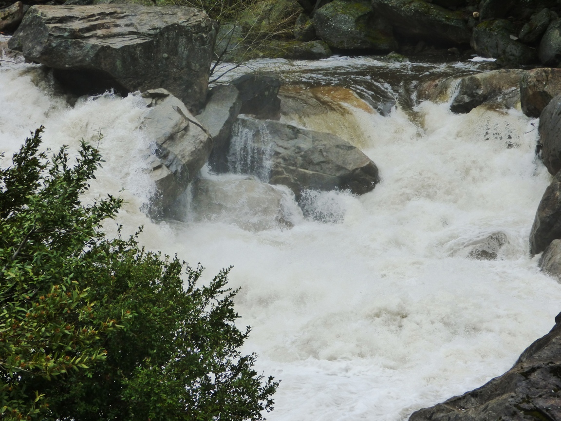
The Merced River was a raging fury. The very warm March and April dry periods were causing an early snowmelt so the river was running high, and the widespread rain added to the runoff. Average flow for early April is around 800 cubic feet per second. The flow of the river yesterday was at least three times average, around 2,800 cfs.
The flow yesterday may have been a record for the date (although I'm not quite clear how to interpret the graph on that count). The river was not actually officially flooding (it would have to reach 6,600 cfs), but flows yesterday were consistent with the peak runoffs that normally occur in late May and early June. The record low flow for the date was just set last year, at 244 cfs. The greatest recorded flood ever occurred during the El Nino year of 1997 when the river reached 24,600 cubic feet per second.
Whether assisted by yesterday's freak rainstorm or not, the high flows are a bit ominous. The future of the Merced River under the most generous of global warming scenarios includes the possibility of more precipitation, but far less snow. That means earlier runoff and less chance to store water in reservoirs because of the necessity to leave room for flooding events.
That being the case, I had a field studies class scheduled yesterday to Yosemite Valley. The weather forecasts (which had not really predicted the prodigious amounts of rain) suggested that the storm was waning and that we might see some clearing in the afternoon when we arrived at the valley. We have schedules to keep, and timelines to follow, so the trip left as planned. It never stopped raining for a minute that entire trip from start to finish.
Despite the nonstop rain, we accomplished most of our goals, and saw most of the features of Yosemite and the Merced River Canyon (Half Dome was a no-show, though). We managed to thread our way through the day, catching some stops when the rain had declined to a drizzle, or having a sheltered place to discuss the geological features of particular stops.
One of our first stops was on Highway 140 to Mariposa, where we got to see an outcrop of the Mariposa Slate, a former mudstone from the deep ocean floor that had been compressed and baked into a hard sequence of slate and phyllite. The rocks have been uplifted and tilted, but as one can see in the picture above, folded into a series of very tight 'v's. The rocks have been on a long journey, forming on the floor of the Pacific Ocean, and being swept under the North American plate. We are looking at the part of the seafloor that was scraped off and added to the continental edge around 200 million years ago.
The Merced River was a raging fury. The very warm March and April dry periods were causing an early snowmelt so the river was running high, and the widespread rain added to the runoff. Average flow for early April is around 800 cubic feet per second. The flow of the river yesterday was at least three times average, around 2,800 cfs.
The flow yesterday may have been a record for the date (although I'm not quite clear how to interpret the graph on that count). The river was not actually officially flooding (it would have to reach 6,600 cfs), but flows yesterday were consistent with the peak runoffs that normally occur in late May and early June. The record low flow for the date was just set last year, at 244 cfs. The greatest recorded flood ever occurred during the El Nino year of 1997 when the river reached 24,600 cubic feet per second.
Whether assisted by yesterday's freak rainstorm or not, the high flows are a bit ominous. The future of the Merced River under the most generous of global warming scenarios includes the possibility of more precipitation, but far less snow. That means earlier runoff and less chance to store water in reservoirs because of the necessity to leave room for flooding events.
Saturday, April 4, 2015
A Day on the Stanislaus: There's Still Some Water in California
It's not nearly enough, and the runoff from the snows of winter will be the worst ever, but there is still a little bit of water in California. The rivers aren't dry yet.
It's been a strange year, because by the rain gauge in my backyard, we have received near-normal precipitation. The total so far, 10.5 inches, is just short of the normal 12 inches we get in an average year (as if average years ever happen). The problem is that about seven of those inches came during an extraordinary sequence of Pineapple Express storms in December that dropped lots of rain in the Great Valley and Coast Ranges. But the storms almost entirely missed the Sierra Nevada, and because the storms were warm, very little snow fell at all. So the effect of the storm was to add several feet of water to the reservoirs, mainly in the northern Sierra Nevada, and with not a drop of rain in January, and only a few weak storms in February and March, we as a state are in dire straits. The last snow report was just 6% of normal. The worst drought in recorded history. And it is now the fourth year.
The governor has for the first time ever called for mandatory cutbacks in domestic water use, which will help, but since 80% of the water used in the state goes to agriculture, more will be needed. And what happens if the drought continues? There is evidence of two megadroughts lasting as long as a century during the last 2,000 years. Are we in the beginning of another epic drought? Who can say?
In the meantime, the rivers are still flowing. Not enough, not nearly as much as should be flowing at this time of year, but the few storms we had were spaced just well enough to promote some wildflower growth, and for the time being, most of the Sierra Nevada foothill slopes are green or nearly so. And another storm is predicted for Tuesday, with hopes of maybe another half inch of rain.
I was out for a short walk this afternoon at Horseshoe Bend Park on the Stanislaus River. The Stanislaus is the first major Sierra Nevada river north of Yosemite National Park. The headwaters are located near Sonora Pass. There are several reservoirs upstream, including the massive New Melones Dam, built in the 1970s. To make up for the sections of beautiful river that were destroyed, the Army Corps of Engineers constructed a series of parks on the downstream stretches of the river between the dam and the confluence of the Stanislaus and the San Joaquin. At Horseshoe Bend there is an old gravel pit that has filled with groundwater forming an attractive pond, and a small campground for river rafters. It was a pleasant place to walk this afternoon.
The flowers were mostly bush Lupine and Golden Poppies. There were quite a few water birds about, mostly Canada Geese, American Coots, and an American Wigeon. There were a dozen or more Turkey Vultures and several hawks as well.
The sound of flowing water is a precious thing in a year like this. I tried to make the most of it!
We'll be back to our blog series on the Most Dangerous Plate Boundary quite soon.
It's been a strange year, because by the rain gauge in my backyard, we have received near-normal precipitation. The total so far, 10.5 inches, is just short of the normal 12 inches we get in an average year (as if average years ever happen). The problem is that about seven of those inches came during an extraordinary sequence of Pineapple Express storms in December that dropped lots of rain in the Great Valley and Coast Ranges. But the storms almost entirely missed the Sierra Nevada, and because the storms were warm, very little snow fell at all. So the effect of the storm was to add several feet of water to the reservoirs, mainly in the northern Sierra Nevada, and with not a drop of rain in January, and only a few weak storms in February and March, we as a state are in dire straits. The last snow report was just 6% of normal. The worst drought in recorded history. And it is now the fourth year.
The governor has for the first time ever called for mandatory cutbacks in domestic water use, which will help, but since 80% of the water used in the state goes to agriculture, more will be needed. And what happens if the drought continues? There is evidence of two megadroughts lasting as long as a century during the last 2,000 years. Are we in the beginning of another epic drought? Who can say?
In the meantime, the rivers are still flowing. Not enough, not nearly as much as should be flowing at this time of year, but the few storms we had were spaced just well enough to promote some wildflower growth, and for the time being, most of the Sierra Nevada foothill slopes are green or nearly so. And another storm is predicted for Tuesday, with hopes of maybe another half inch of rain.
I was out for a short walk this afternoon at Horseshoe Bend Park on the Stanislaus River. The Stanislaus is the first major Sierra Nevada river north of Yosemite National Park. The headwaters are located near Sonora Pass. There are several reservoirs upstream, including the massive New Melones Dam, built in the 1970s. To make up for the sections of beautiful river that were destroyed, the Army Corps of Engineers constructed a series of parks on the downstream stretches of the river between the dam and the confluence of the Stanislaus and the San Joaquin. At Horseshoe Bend there is an old gravel pit that has filled with groundwater forming an attractive pond, and a small campground for river rafters. It was a pleasant place to walk this afternoon.
The flowers were mostly bush Lupine and Golden Poppies. There were quite a few water birds about, mostly Canada Geese, American Coots, and an American Wigeon. There were a dozen or more Turkey Vultures and several hawks as well.
The sound of flowing water is a precious thing in a year like this. I tried to make the most of it!
We'll be back to our blog series on the Most Dangerous Plate Boundary quite soon.
Tuesday, March 25, 2014
Finding Gold in the Mother Lode (but not that kind): A bit of color in drought-stricken California
Our search for gold in the Mother Lode of the Sierra Nevada foothills was successful, but we weren't looking for that kind of gold. Yes, these gentle hills once hosted one of the greatest gold rushes in history, but the mines have been silent for many decades. Today, the Mother Lode is a tourist destination, and one of the attractions is the spring wildflower show. In the last post, we saw how a few endemics are showing up this week on the serpentine soils in the Red Hills Area of Critical Environmental Concern. Serpentine occurs in bands associated with the Melones Fault Zone which divides two major terranes, the Calaveras Complex and the Foothills Terranes. The Mother Lode gold-bearing quartz veins occur along this same boundary.
Highway 49 winds for 150 miles or so along the Mother Lode, and as we saw in the last post, the early flower shows are patchy, and are helped in places by runoff from the asphalt. The hills are green for the moment, but the green will not last long. In most normal years, 90% of the rain has fallen by now, and we have received maybe 25% of the rain we usually expect. It's the worst drought ever recorded. The green grass in these pictures will start turning brown in a few short weeks, and we can look forward to a hot, dry and fiery summer season.
So the early wildflowers are out, and if the expected storm arrives tomorrow, they might receive enough water to last a few more weeks. One thing I know from years of exploring southwest deserts, flowers in a dry place are precious to behold. So enjoy some of the color we discovered last weekend.
There were occasional patches of Foothills Poppies.
The Redbuds were in bloom, adding bright splotches of purple or pink to the hillsides.
Lupines seem to do well in lots of environments along the Mother Lode.
These pleasing-looking leaves are not good for touching or picking; this is the ever-present Poison Oak. The leaves are colorful and eye-catching throughout much of the summer season and into the fall.
We reached the Moccasin Creek area and saw where the Marshes Flat Road diverges from Highway 49 and heads west through the metavolcanics and metasedimentary rocks of the Foothills Terranes. These Jurassic rocks were deposited on the sea floor and scraped off into the vast subduction zone complex that once extended from Canada to Mexico and beyond. Today the rocks are tilted to an almost vertical attitude. On the meadowlands around Marshes Flat the rocks are rarely seen, as they are covered with fairly deep soils.
The road is a pleasant backcountry avenue that serves as access for several ranches. It's usually an uncrowded drive.
The metavolcanic rocks show up when the road starts down the steep slopes towards Don Pedro Reservoir. Although there was almost no water in the creeks, some of the slopes had pockets of blooming flowers, including these Shooting Stars.
If these are Shooting Stars, are the two flowers below star-crossed lovers?
Near a creek we found some wild onion blooming.
And a moving rock. Seriously, why is there a track here, and what moved the rock?
We saw that the sun was getting low in the sky, and I had a lot of grading to attend to, so we headed home. I hope the blooms last long enough for another trip before summer sets in!
Highway 49 winds for 150 miles or so along the Mother Lode, and as we saw in the last post, the early flower shows are patchy, and are helped in places by runoff from the asphalt. The hills are green for the moment, but the green will not last long. In most normal years, 90% of the rain has fallen by now, and we have received maybe 25% of the rain we usually expect. It's the worst drought ever recorded. The green grass in these pictures will start turning brown in a few short weeks, and we can look forward to a hot, dry and fiery summer season.
So the early wildflowers are out, and if the expected storm arrives tomorrow, they might receive enough water to last a few more weeks. One thing I know from years of exploring southwest deserts, flowers in a dry place are precious to behold. So enjoy some of the color we discovered last weekend.
There were occasional patches of Foothills Poppies.
The Redbuds were in bloom, adding bright splotches of purple or pink to the hillsides.
Lupines seem to do well in lots of environments along the Mother Lode.
These pleasing-looking leaves are not good for touching or picking; this is the ever-present Poison Oak. The leaves are colorful and eye-catching throughout much of the summer season and into the fall.We reached the Moccasin Creek area and saw where the Marshes Flat Road diverges from Highway 49 and heads west through the metavolcanics and metasedimentary rocks of the Foothills Terranes. These Jurassic rocks were deposited on the sea floor and scraped off into the vast subduction zone complex that once extended from Canada to Mexico and beyond. Today the rocks are tilted to an almost vertical attitude. On the meadowlands around Marshes Flat the rocks are rarely seen, as they are covered with fairly deep soils.
The road is a pleasant backcountry avenue that serves as access for several ranches. It's usually an uncrowded drive.
The metavolcanic rocks show up when the road starts down the steep slopes towards Don Pedro Reservoir. Although there was almost no water in the creeks, some of the slopes had pockets of blooming flowers, including these Shooting Stars.
If these are Shooting Stars, are the two flowers below star-crossed lovers?
Near a creek we found some wild onion blooming.
And a moving rock. Seriously, why is there a track here, and what moved the rock?
We saw that the sun was getting low in the sky, and I had a lot of grading to attend to, so we headed home. I hope the blooms last long enough for another trip before summer sets in!
Monday, March 18, 2013
California's Great Valley Turns Technicolor
Springtime is arriving in the Sierra Nevada foothills and the Great Valley (most people know it as the Central Valley, but we have our pride). This is the time when the rare rains have awakened the long dormant seeds of wildflowers, and for a few short weeks, the flowers will grow, bloom, and go to seed before the summer heat kills them off. Because agricultural development has preempted most of the valley floor, the wildflowers are best seen by traveling into the Sierra foothills to the east or the Coast Ranges to the west.
These pictures were taken near the Caliente turnoff of Highway 58 about 20 miles east of Bakersfield, and on Highway 223 above the small town of Arvin. The earliest bloomers seem to be the fiddlenecks. They are considered weeds by some, but they make for a colorful start to the spring bloom.
Some of the trees were emerging from their winter slumber. I'm not sure what kind of trees these were, but the red leaves provided an interesting contrast to the yellow fields of fiddlenecks.
As we were hunched over taking photos of the fiddlenecks, some folks stopped their car and suggested we should head down Highway 223 to catch the poppies. It was good advice!
Some of the hillsides were covered by carpets of purple and orange which to my eyes is one of the most beautiful of color combinations. In some places they were segregated, but in others they were totally mixed in an explosion of color. I caught a hawk soaring over the hillside.
Then we turned a corner, and I had a brief vision how the Great Valley looked before the land was co-opted by orchards and vineyards. We have to eat, and the Great Valley is one of the most productive agricultural regions on our planet, but I do sometimes wistfully wonder just what it was like to wander this landscape for those few weeks in spring when the whole valley was awash in bright colors. It must have been astounding, just as these few acres of grasslands were astounding last Sunday.
If you have any excuses to visit the Great Valley, this is the time to do it!
These pictures were taken near the Caliente turnoff of Highway 58 about 20 miles east of Bakersfield, and on Highway 223 above the small town of Arvin. The earliest bloomers seem to be the fiddlenecks. They are considered weeds by some, but they make for a colorful start to the spring bloom.
Some of the trees were emerging from their winter slumber. I'm not sure what kind of trees these were, but the red leaves provided an interesting contrast to the yellow fields of fiddlenecks.
As we were hunched over taking photos of the fiddlenecks, some folks stopped their car and suggested we should head down Highway 223 to catch the poppies. It was good advice!
Some of the hillsides were covered by carpets of purple and orange which to my eyes is one of the most beautiful of color combinations. In some places they were segregated, but in others they were totally mixed in an explosion of color. I caught a hawk soaring over the hillside.
Then we turned a corner, and I had a brief vision how the Great Valley looked before the land was co-opted by orchards and vineyards. We have to eat, and the Great Valley is one of the most productive agricultural regions on our planet, but I do sometimes wistfully wonder just what it was like to wander this landscape for those few weeks in spring when the whole valley was awash in bright colors. It must have been astounding, just as these few acres of grasslands were astounding last Sunday.
If you have any excuses to visit the Great Valley, this is the time to do it!
Sunday, March 17, 2013
Life from an Ant's Point of View: Springtime in the Sierra Foothills
I find that the average lifespan of an ant is something like a month or two. So bear with me while I have some silly thoughts about ant culture. What must the average ant think when it sees the explosion of color above when spring arrives in Sierra Nevada foothills? Probably not much, but it's fun to imagine the legends they might pass on down through the generations. "Your great aunt ant? Remember her? She was so old: four months. She told us of a time when the brown stalks were green and alive with color, and there was sweet nectar in the midst of the plants, and it was a time of richness, never to be forgotten in our legends"
I was off on another adventure this weekend. It was work, actually, helping a relative move in Southern California. I've been down Highway 99 probably 150 times in the last 25 years, so when we woke up this morning, the San Bernardino to Bakersfield drive prior to following Highway 99 to our home near Modesto just did not seem all that...appealing.
Luckily, we did not have a strict schedule, so we got very creative, seeing if we could spend as little time as possible on Highways 58, 14 and 138, and despite all my explorations, we found four roads that I have never traveled, or hadn't traveled in more than 25 years. They included Lone Pine Canyon along the San Andreas fault near Cajon Pass, Backus Road and Willow Springs Road outside of Mojave, Woodford-Tehachapi Road at the top of the Tehachapi Mountains, and Arvin Road at the bottom of the Tehachapi Mountains. Four adventures in one day, capped by the 200 mile drive on Highway 99 to Modesto. We had the most fun on the first part...
I took 200 pictures, and Mrs. Geotripper took even more, so there are probably a few more posts coming in the next few days, discussing faults, wind energy, trains, and wildflowers. Since wildflowers are the subject of today's photos, I can report that spring has arrived at the very south end of the Great Valley, and there are some beautiful sights along Highway 223 out of Arvin to the junction with Highway 58. It's been a dry year, so I don't know how the long the show will last. I don't know how often people find a reason to visit Arvin, but this is a really good time to head there. More coming on wildflowers!
Meanwhile, please enjoy these few shots of life from an ant's point of view....
I was off on another adventure this weekend. It was work, actually, helping a relative move in Southern California. I've been down Highway 99 probably 150 times in the last 25 years, so when we woke up this morning, the San Bernardino to Bakersfield drive prior to following Highway 99 to our home near Modesto just did not seem all that...appealing.
Luckily, we did not have a strict schedule, so we got very creative, seeing if we could spend as little time as possible on Highways 58, 14 and 138, and despite all my explorations, we found four roads that I have never traveled, or hadn't traveled in more than 25 years. They included Lone Pine Canyon along the San Andreas fault near Cajon Pass, Backus Road and Willow Springs Road outside of Mojave, Woodford-Tehachapi Road at the top of the Tehachapi Mountains, and Arvin Road at the bottom of the Tehachapi Mountains. Four adventures in one day, capped by the 200 mile drive on Highway 99 to Modesto. We had the most fun on the first part...
I took 200 pictures, and Mrs. Geotripper took even more, so there are probably a few more posts coming in the next few days, discussing faults, wind energy, trains, and wildflowers. Since wildflowers are the subject of today's photos, I can report that spring has arrived at the very south end of the Great Valley, and there are some beautiful sights along Highway 223 out of Arvin to the junction with Highway 58. It's been a dry year, so I don't know how the long the show will last. I don't know how often people find a reason to visit Arvin, but this is a really good time to head there. More coming on wildflowers!
Meanwhile, please enjoy these few shots of life from an ant's point of view....
Labels:
Ant's point of view,
California poppies,
Fiddleneck,
Lupine,
wildflowers
Subscribe to:
Posts (Atom)