Showing posts with label Sierra Nevada foothills. Show all posts

Saturday, May 11, 2024

A Stunning Night: The Aurora Borealis from Central California

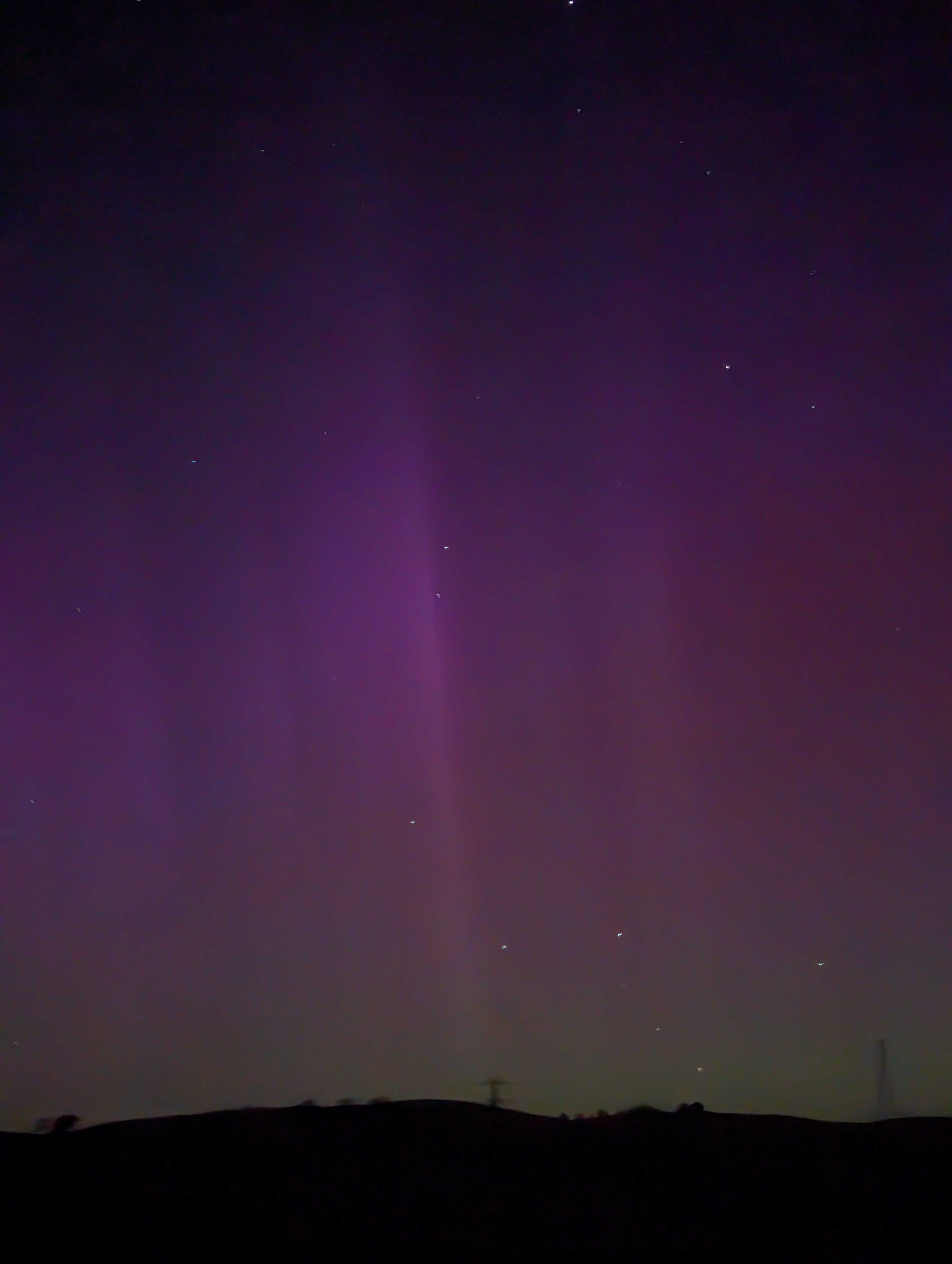
It has been a stunning night. I never believed the auroras would make it into Central California, and most of the predictions suggested it wouldn't. But then reports started pouring in; sightings in South Carolina, northwest Florida, Houston, and then Death Valley. I had to give it a chance. Mrs. Geotripper and I hopped in the car and headed out to the California Prairie south of Knights Ferry.
As we pulled up at the small stock pond on Willms Road, it didn't look like much was going on. I convinced myself that there was a bit of a red glow in the sky, and I started taking pictures with my phone (my regular camera turned out to be useless for once). On the screen it wasn't obvious, but there was indeed some color. 
I would have been satisfied with that, as I have seen the aurora only twice before. The first time was from within the Grand Canyon on my very first geology field studies trip in 1975. It was just a glow in the sky then, and we thought it was light pollution from Las Vegas or St. George, but it turned from red to green. We were awestruck, but there was no structure to be seen. The other time was in the late 1990s when we were in Montana on a mostly rainy night, but for a short moment a filament appeared through the clouds. And that was that.
Having so little experience with the phenomena, I simply didn't know what to expect, but we were becoming aware that the lights were changing as we watched. Spires came and went, and the glow moved to different parts of the sky. The colors were changing as well.
We watched until midnight when the cold breeze and lack of facilities forced us to start the drive home, but as we went around each bend, we couldn't resist stopping a moment to see what changed.
The changes were many. More and more green was showing near the horizon, and blue or purple appeared off to the west.


Needless to say maybe, but it was an astounding thing to see. I should note that while I have not modified the pictures (especially the saturation), the phone camera did see more vivid color than I did. I was using the night shot setting, so it was collecting light for two or three seconds, so the pictures are more colorful. But even so, it was easy to understand why the ancients thought these lights emanated from the gods.
We have our own mythology about these strange lights in the sky. They are the magnetic force shields protecting us from deadly emanations from the sun. Without our magnetic field, life on Earth might never have appeared, and we continue to thrive as long as the field continues.
After studying the Earth and the cosmos for more than forty years, I still can be impressed by the incredible processes that operate on and around our planet. What a privilege to live in and understand our world.

The storm is expected to continue through the weekend. I encourage you to find a dark place and check it out, but if that isn't possible, I hope this gives you an idea of what it was like!
 

Sunday, January 1, 2023

Dry Creek: Anatomy of a Flood (One of Many Across California Today)


After days of gloomy and wet weather, New Year's Day dawned bright and sunny, and we couldn't resist driving out into the California prairie to have a look at the beautiful landscape. The streams across the prairies east of Modesto were full and flowing in a way we haven't seen for a number of years. And that's the problem of course. 

This creek, normally dry, was just one of many dozens of tributaries to Dry Creek, which is itself an unregulated, undammed tributary to the Tuolumne River. This entire area received upwards of five inches of precipitation in the last day or two, and all the water had to go somewhere.

I included a picture of Dry Creek in my post yesterday, when it was flowing at about 600 cubic feet per second (cfs). I am including another picture below, taken at the same time, but from an angle that shows the pasture to the left. I knew that more water would be coming downstream, maybe as much as 1,500 cfs, an amount that would actually be more, by a wide margin, than the main drainage in the area, the Tuolumne River.

That's not quite what happened...

When we crossed the Dry Creek Bridge north of Waterford today, the creek was running at 6,000 cubic feet per second, more than ten times the flow of the previous day. Take a look below at what happened to the pasture (not to mention all the shrubs and brambles at the base of the oak trees).

By the time we arrived in the prairies in the afternoon today, most of the floodwaters had subsided in the upper watershed, but we could see evidence everywhere that a significant flood event had taken place. Rocks were strewn across the roadways, and every watercourse showed evidence of having been feet deeper the previous day. One bridge we crossed would have been four feet underwater during the height of the storm. 

The flood hydrograph below tells the story. The data is taken from a stream gage downstream in Modesto. The bar graph at the top shows the pattern of the rainfall in the storm up in the watershed, and the subsequent rise of Dry Creek. Notice how the rise of the creek lagged behind the precipitation. This so-called lagtime makes sense because it takes time for the water to gather into the tributaries and then to flow the twenty miles or so downstream. Lagtime represents the critical hours that residents downstream can prepare for the oncoming flood.

Wouldn't it be nice if there were a government entity that could monitor all rivers and all flood events so that when such events unfold, there could be timely warnings? Perhaps even keeping records of storms over the course of a century or more, so that specific warnings could be made about the timing and the expected intensity of the oncoming flood? Unlike earthquakes, floods can be predicted, and there are in fact government institutions that are tasked with this job, mainly the United States Geological Survey (across the entire US), and the Department of Water Resources specifically in California.


Which brings us to the handy-dandy bottom portion of the hydrograph. The blue line on the graph is what happened already. The pink line is the prediction. We have another intense storm coming on Wednesday, and after dropping to around 300 cfs, Dry Creek is going to rise again to at least 6,000 cfs and maybe more. Isn't it nice that we have several days warning? That's just one huge example of the value of science in our society.

Of course, no one is perfect, and all models and predictions can be affected by unknown and unexpected factors. The storm this week offers one tragic example. Although most streams and rivers behaved more or less as predicted, the Cosumnes River defied the predictions and produced record flooding, well beyond the predicted levels. 

What went wrong? Those who do science fully understand that errors happen, and it their goal is to understand the reason for such errors. The factors in the Cosumnes River flooding are being analyzed and may include an unexpected slowing of the storm front causing increased precipitation, two or three broken levees, and the Caldor Fire of 2021 that ravaged much of the watershed upstream. If you want to follow the analysis, check out the Weather West blog by Daniel Swain (@Weather_West on Twitter).

So, there is my science homily for the day. But we were out to explore some nature, and in any case, we need to appreciate the gifts we have been given. The day, a respite from a long series of expected storms, was beautiful. 


Mountain Bluebirds are not common on the valley floor, but we saw a small flock along the road.


An American Kestrel is a sharp-looking small member of the falcon family. This one remained perched near our car for a few moments.


Bald Eagles are not especially abundant in the region, but we found one. So had an 'unkindness' of Common Ravens, and they were making their displeasure known to the eagle.

And finally, an old horse seemed to appreciate the sunshine. The horses were brought to the continent by the Spaniards in the 1500s, but they actually have a long heritage here. They evolved in North America tens of millions of years ago! They migrated across the Bering Land Strait and spread throughout the world, but for some reason went extinct along with many other large mammal species in North America about 12,000 years ago.


Saturday, October 9, 2021

The Prairies of California: the Most Extraordinary Landscape (and Ecosystem) in California

The Tuolumne River on the east side of the Great Valley

I admit this statement is a hard sell, especially among those who live here, but hear me out: the Great Valley prairie is the most extraordinary landscape and ecosystem in California

The Great Valley prairie remnant east of Modesto

"But", they will say, "the valley is boring. It is just one long flat plain full of farms, feedlots, oil derricks, and urban hellscapes. It's dusty and the air is bad. And there is nothing to do." And from their point of view, their statement is valid. But that's not the part that I am talking about. I'm talking about the valley that once was, and more importantly, the 5% of the valley that is not given over to agriculture and urban development. It is that small bit that teaches us what once was. 

I was thinking a lot about the original valley today.

Prairie and wetlands at the San Luis National Wildlife Refuge south of Turlock

The occasion was World Migratory Bird Day, Global Bird Weekend, and eBird's October Big Day. The purpose of the day is to gain a one-day snapshot of the world of birds, and birdwatchers all over the world contributed observations. For myself, I decided I wanted to capture as much of the primeval Great Valley prairie as I could, so I selected three habitats for the day: the valley wetlands and marshes, the riparian environment, and the dryland prairies that once filled the spaces between the rivers and wetlands. In the end Mrs. Geotripper and I explored the Merced National Wildlife Refuge and the San Luis National Wildlife Refuge, and in the afternoon I walked the Tuolumne River Parkway Trail (as I often do). As the sun began to set I took a drive through the prairies between the Tuolumne and Stanislaus Rivers east of Modesto. In all we saw nearly 60 species of birds.

One of the most extraordinary facts about the prairie lands of California is that they ever existed at all. The Great Valley is 400 miles long and 30-40 miles wide, and with the exception of a single volcanic center at Sutter Buttes, is as flat as any place on Earth. The entire American West is characterized by rugged mountainous topography, including the Coast Ranges and Sierra Nevada of California between which the Great Valley is sandwiched. Such a large mostly flat region is akin to finding a serene quiet lake surface in the midst of an intense hurricane.


The origin of the Great Valley lies in the violent tectonics of the subduction zone that existed off the coast of California for at least 200 million years. A region of oceanic crust was being driving beneath the western edge of the North American continent, forming a trench and a deformed mass of sediment called an accretionary wedge. Parts of the accretionary wedge were buoyed upwards to become the core of California's Coast Ranges.

As the slab of ocean crust sank into the Earth's mantle, portions of the plate melted and formed vast plutons of magma that melted their way through the overlying continental crust, forming an extensive volcanic chain called a magmatic arc. The deeper parts of the magmatic arc eventually cooled to become the granitic rocks of the Sierra Nevada.

Between the geologically violent wedge and arc though was a shallow sea that simply collected sediments washed off the land. This sedimentary trough is known as a forearc basin. As the sediments accumulated, they pressed the crust downwards, providing room for additional sediments. Eventually these silt and sand layers reached a thickness of 25,000 feet or more. These sediments became the floor of the Great Valley.

Source: National Park Service

The valley was below sea level for most of its first 140 million years, but in the last four or five million years the floor of the valley was lifted slightly above sea level to become the plain it is today. It is dry in large part because the adjacent Coast Ranges act as a barrier to incoming storms from the Pacific Ocean. It is literally a desert in the southern portions from Fresno to Bakersfield, but the dry plain is crossed by numerous rivers flowing out of the Sierra Nevada.

In antiquity the valley was a vast prairie, a grassland stretching 400 miles from what is now Bakersfield to Redding. The drylands were broken up by a system of rivers, marshes and wetlands that supported groves of oak, cottonwood, and sycamore and vast thickets of willows and shrubs. These plants supported a rich fauna.

Until roughly 12,000 years ago, the prairies were populated by millions of grazing animals including horses, camels, deer, elk, bison, and even elephant species like mammoths and mastodons. This megafauna was preyed upon by a terrifying roster of predators including saber-tooth cats, 
lions, cheetahs, dire wolves, and bears, including the California Grizzly and the even larger short-faced bear. The cause of the extinction of most of these species is still debated, but the prime suspects are climate change and overhunting by newly-arrived humans. A minority view argues for an asteroid impact that primarily affected North America.

Sandhill Crane and Great Egret at the Merced National Wildlife Refuge

In the aftermath of the extinctions, the valley still supported a robust ecosystem. The mild winters provided shelter for millions of migratory birds, and the grasslands were grazed by elk, deer, and antelope. Predators included wolves, coyotes, foxes, mountain lions, and bears. The Tule Elk were thought to have been hunted to extinction in the years after the Gold Rush, but a small remnant of the species survived on a single ranch at the south end of the valley. The California grizzly and wolves were eliminated in the early 1900s. 

Tule Elk bull at the San Luis National Wildlife Refuge. We didn't see any today so I borrowed a shot I took in 2016

Today the remaining original prairie and wetlands environments are present due to sheer luck, and from concerted efforts by many environmental organizations and government agencies. A series of national wildlife refuges have been established like a string of pearls up and down the valley to provide habitat for the millions of migrating cranes, geese, swans and other species.

The White-faced Ibis is a tropical species that looks almost black until the sun shines on the iridescent feathers. The white face appears in the breeding season.

Some grass prairies are preserved in state parks and national monuments (most notably Carrizo Plains National Monument). But most persist because they are on cattle ranch property. These private lands are threatened by the rapid expansion of almond groves into the foothills. In my county alone, tens of thousands of acres have been planted, with no secure irrigation sources for the thirsty trees. I'm pretty sure they'll be abandoned within a decade or so as the groundwater they are using dries up.

Dry Creek, shown here, has earned its name this year, although it is capable of serious flooding in wet years. An invading and misguided almond orchard can be seen at upper right.

The riparian habitats have their own problems. The river woodlands are among the least-affected environments as attempts to develop them as farmlands tended to fail because of repeated flooding. Still, much damage was done in the attempt, and current efforts are directed at replanting native species in floodplains that have reverted to government or conservancy ownership.

The Tuolumne River near the Sierra Nevada foothills.

It is the rivers themselves that face the biggest challenges. There is no more contentious issue in the Great Valley than water use and distribution, especially in severe drought years. All of the major rivers are dammed and strictly controlled except for the occasional exceptional flood. The Tuolumne has been kept at a minimal flow, enough to maintain a string of river water into the delta. The slow-moving water is subject to warming to a dangerous level for river species, and the expansion of invasive species like river hyacinth. Through it all the river is a beautiful walk at all times of the year.

Sandhill Cranes at the San Luis National Wildlife Refuge

It was a serene day, but it was also the calm before the storm. The migratory birds are beginning to arrive in greater numbers, and soon these pools will be filled with Snow and Ross's Geese, Tundra Swans, and Aleutian Cackling Geese. There is nothing quite like seeing a flock of 10,000 geese take off all at once. It becomes so easy to imagine what once was in this most extraordinary place.

Friday, May 7, 2021

Went Looking for Rocks and Birds, Came Back With Flowers and Butterflies

Oh boy, do I ever have a blind spot for learning. I can't learn flowers or butterflies. I'd blame it on age, but I've managed to learn something like 200 bird names in the last three years, so it's not that. Whatever the cause, I headed into the hills of the Sierra Nevada today looking for rocks and birds, but I came home with a bunch of flower pictures with butterflies that I couldn't confidently identify. So I won't try...I'll depend on your help! The comments section is below.
We were headed to Yosemite Valley to see the waterfalls before they dried up (it has been an excruciatingly dry year). We had already missed what was apparently a spectacular Golden Poppy extravaganza in the Merced River canyon downstream of Yosemite, but there were still plenty of wildflowers to be seen, especially on the shady north-facing slopes. But the unexpected delight of the day was the abundance of butterflies on what flowers there were.
One poor individual flew into our car and had a confusing time trying to get nectar from a pillow.
There was even bits of drama with butterflies vying for the best flowers. The one in the pictures above and below drove off several Checkerspots.
I guess if I get tired of trying to identify every bird I see, I'll turn to flowers and butterflies. The thing is, birds are a year-round project. The flowers are ephemeral, and so are the organisms that feed off of them.
There weren't just butterflies in the wildflower fields. I caught the Ladybug below too, and any number of bees and flies.
It was a spectacular day, and not just from the flowers. Look for some new posts on Yosemite Valley as soon as I get the chance!
 

Sunday, April 4, 2021

California's Rarest Ecosystems: The Prairies and Vernal Pools (Part One of a Two-part Miniseries)

The lower foothills of the Sierra Nevada are one of the most unique and almost universally ignored parts of California. Caught between the famous and heavily-visited forests and alpine regions of Yosemite's high country and the utilitarian agricultural fields of the Great Valley, the lower foothills are made of soils too poor to be developed, and too "plain" to be noticed by people rushing up the highways to the mountain resorts. For much of the year they seem barren and lifeless. But these prairies are one of the most precious of California's diverse ecosystems.
The prairies of California once extended the length of the Great Valley, a 400-mile-long grassland supporting millions of grazing animals, birds, and predators, including Tule Elk, Pronghorn, Deer, Grizzly Bear, Mountain Lions, Coyotes, Foxes, and numerous rodents, reptiles, amphibians, fish, and insects. In earlier times (more than 10,000 years ago) there were camels, horses, bison, giant ground sloths, Columbian Mammoths, Saber-tooth Cats, and Dire Wolves.

There were also modern-day wolves, and it is ironic and coincidental that a wolf returned this week to the Great Valley for the first time in a century. It is a young male from Oregon who made an epic journey through Modoc County into the Sierra Nevada near Yosemite Valley, and then into the Sierra foothills of Fresno County, and across the Great Valley (including two freeway crossings). At last report it's now in Monterey County (it's wearing a radio transmitter). 

The prairies were covered with native grasses that were quickly replaced by invasive species when European colonizers arrived and started herding sheep and cattle. Farms eventually replaced the ranches, and the remaining prairies, no more than 5% of the original land cover, were relegated to the fringes where the soils were poor and no water was available for irrigation. Those remaining prairies form a belt through the foothills of Sierra Nevada.  A narrow remnant can be found along the Coast Ranges and the Carrizo Plains west of Bakersfield.
The prairie soils in the Sierra Nevada foothills are notably poor in nutrients because they have not been part of an active floodplain in tens of thousands of years, and the fertile components have been leached away, leaving behind reddish iron oxides and thick clays. Differential settling and wind deflation has left small hollows and depressions that collect rainfall during the relatively rare winter storms. The clay prevents the water from seeping underground, so pools will persist for weeks or months at a time. These pools are the basis for one of California's rarest ecosystems, the vernal pools.
The vernal pools are islands of diverse life in the otherwise barren grasslands. Numerous species of plants and wildflowers, amphibians, and invertebrates have evolved to survive the weeks of water and the months of dryness. As the waters evaporate away, one species of plant after another germinates, grows, and goes to seed. The pools are often rimmed in colorful zones of different flowers.
I'm writing about the vernal pools today because the limitations of travel in the times of a pandemic have kept me pretty close to home. I live on the edge of the prairie between the Tuolumne and Stanislaus rivers and I was out there today. A few pools are left, and flowers are blooming across the region. The views are expansive, extending to the snow-capped peaks of the High Sierra.
The pools and plants provide food and cover for multitudes of bugs and other wiggly organisms, so the pools are trafficked by a large variety of birds, and dozens of species can be identified by discerning and observant individuals, and occasionally by me as well. 
I saw a half-dozen American Avocets in one pond a few weeks ago.
The prairies are one of the best places to see the rare and threatened Burrowing Owls. The area around Crabtree, Willms, and Cooperstown Roads are among the most dependable places to see them in our region.
Savannah Sparrows are a common species, and they'll occasionally cooperate with photographers.
The Western Kingbirds seemed to arrive from their winter homes in Mexico all at once last week. I saw none a week ago, and dozens today, including this one that hung about long enough for a picture.

I have no picture, but I came upon a Gopher Snake in the road that was in serious danger of being run over. I stopped, looked at it carefully to make sure it wasn't a rattlesnake, and then I picked it up to put it in a safer spot. I was suddenly reminded of how Gopher Snakes sometime pretend to be rattlers! They can flatten their normally narrow heads into the triangle shape of a rattler, and will strike in a similar manner. I didn't hold it for long...how do you explain to the EMTs that you picked up a rattlesnake that you thought was something else?

If you are lucky enough to live near a California prairie, this is a good time of year to explore them. If you tend to rush through this unique part of the Sierra Nevada and the Great Valley on your way to Yosemite or some other mountain destination, slow down and give these precious and unique lands a quick look. You won't be disappointed.
 

Wednesday, January 6, 2021

A Beautiful Scene for a Horrific Day

There aren't many days like this. That can be both a good thing and a bad thing. My country was rocked by a coup attempt and the Capitol Building was invaded and vandalized for the first time in centuries. It dominated my day and little else was accomplished, other than to stare unbelievingly at the screen where the events unfolded in Washington D.C. and various state capitols. When things settled somewhat, we had to get outside, away from the media. And we discovered it was one of the clearest days of the year.
We headed a few miles east to the single best viewpoint I know of in the western foothills of the Sierra Nevada: Turlock Lake State Recreation Area. The lake mainly serves as a fishing and boating site (as well as being a principle irrigation reservoir), but there is some interesting geology, and a wonderful view.

The dam is constructed on the sediments of the Turlock Lake and Mehrten formations, and a number of interesting fossils have been found in the area: mastodons, camels, horses, huge tortoises, and gigantic 9-foot-long tusked (really!) salmon.

East of the main picnic area there is a paved road that climbs to the top of the highest local hill, and on a clear day like this one was, the view extends from the high peaks of Yosemite National Park across the Central Valley to the mountains of the Diablo Range, and the rest of the Coast Ranges. Today was one of the clearest days I've seen in a long time.
Some lenticular clouds were building over the Sierra Crest, making me wish I was I could be up there and a little closer, but that wasn't to be this time. Maybe soon...
Postscript (1/30/21): Anonymous asked what peaks were visible in these pictures. I checked on caltopo.com and found that we were looking at the heart of the Yosemite high country. Here are the caltopo.com images for the last two views above. The first shows from left to right Mt. Simmons, MaClure, Lyell, and Clark.
The second shot shows Mt. Clark, Gray Peak, and Red Peak.