Showing posts with label Yosemite Valley. Show all posts

Saturday, April 12, 2025

Do You Think You Know the Highest Waterfall in Yosemite Valley? You Could Be Wrong!


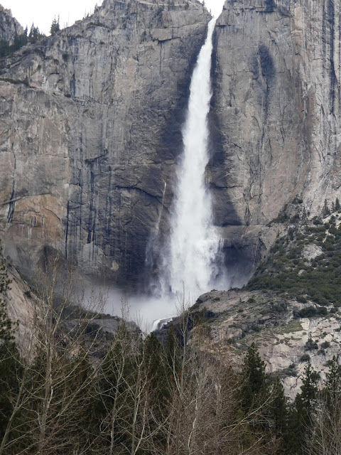
Quick quiz: What is the name of this waterfall?
What is the highest waterfall in Yosemite Valley? Depending on the parameters one can use to determine "height", your assumption may be wrong! Most "authorities" recognize Yosemite Falls (2,425 feet/739 meters) as the highest in Yosemite Valley and North America, and somewhere around the fifth or seventh highest in the world. But it depends on how you decide to measure waterfalls. By a different metric, Yosemite Falls isn't even the highest waterfall in Yosemite Valley. It's the word "falls", in the plural, that makes the difference.

I was in Yosemite Valley yesterday, and the falls were flowing strong. There is no doubt that Yosemite Falls is one of the most stunning sights on the planet. A chance movement of a glacier 13,000 years ago forced a middling stream from its old channel to the left of the current waterfall, forcing Yosemite Creek to drop right off the edge of the sheer cliff. You can see the old channel almost hidden in the shadows in the photo above.
The fall makes a sheer plunge of 1,430 feet (440 meters) at the Upper Fall and then cascades through a series of steep ledges called the Middle Cascades for 675 feet (206 meters). There is a final drop of 320 feet (98 meters) at Lower Yosemite Fall. The Middle Cascades are generally hidden from view unless you hike the steep trail up to the top of the falls (below).
Part of the Middle Cascades (April 2003)
But if one decides to be a purist about such things, one can define a waterfall's height on the basis of the greatest freefall. By that metric, Yosemite Falls still is an imposing 1,425 feet (739 meters) high. But it also means it's not even the tallest waterfall in Yosemite Valley.

Many first-time visitors to the valley are drawn to Bridalveil Falls (620 feet/189 meters) because it is the first major waterfall visible as one enters the valley. But when standing at the base of Bridalveil, they may see another high waterfall across the valley west of the sheer cliff of El Capitan and wonder if it is Yosemite Falls. It's not. It's called Ribbon Fall, and it has a single drop of 1,612 feet (491 meters). That's nearly 200 feet higher than Upper Yosemite Falls (it's the one in the picture at the top of the post). It is less familiar than many of the other waterfalls because it is usually dry by June when the majority of people visit the park. But if you get the privilege of seeing by visiting in the spring, you are in for a treat.
Ribbon Fall (1,612 feet) to the left with the 2,900 foot cliff of El Capitan to the right

Ribbon Falls is one of many treasures that make a spring visit to Yosemite Valley a worthwhile endeavor. If you want to see another springtime waterfall over a thousand feet high, check out Sentinel Falls.

Sunday, October 30, 2022

How It Was Today: Fall in Yosemite Valley

How it ended...

How it began...
I woke up late this morning. Mrs. Geotripper was finishing breakfast and asked if I'd like "to go up the river a little ways and find some fall colors". I had lots of grading to get through, so obviously I said yes, and around 11 or so we jumped in the car and headed up the Tuolumne River to see what we would find. There wasn't much, at least not in terms of fall color. So we went a little farther...
We followed Highway 132 up past Coulterville and on to Greeley Hill at a bit above 3,000 feet. Still not much in the way of fall color. So we went a bit farther up the hill and found ourselves at the Yosemite National Park entrance station at Big Oak Flat at 4,000 feet. We finally found a bit of color, although not at the intensity that a few more days of cold weather might bring. 
And we had made it this far, and Yosemite Valley was only 15 miles away. How could we pass it up? 
So on we went into the awesome gorge of the Merced River and into the valley itself. There was the first look at the distant cliffs of El Capitan (left), Half Dome (center), and Sentinel Rock and Dome (right).
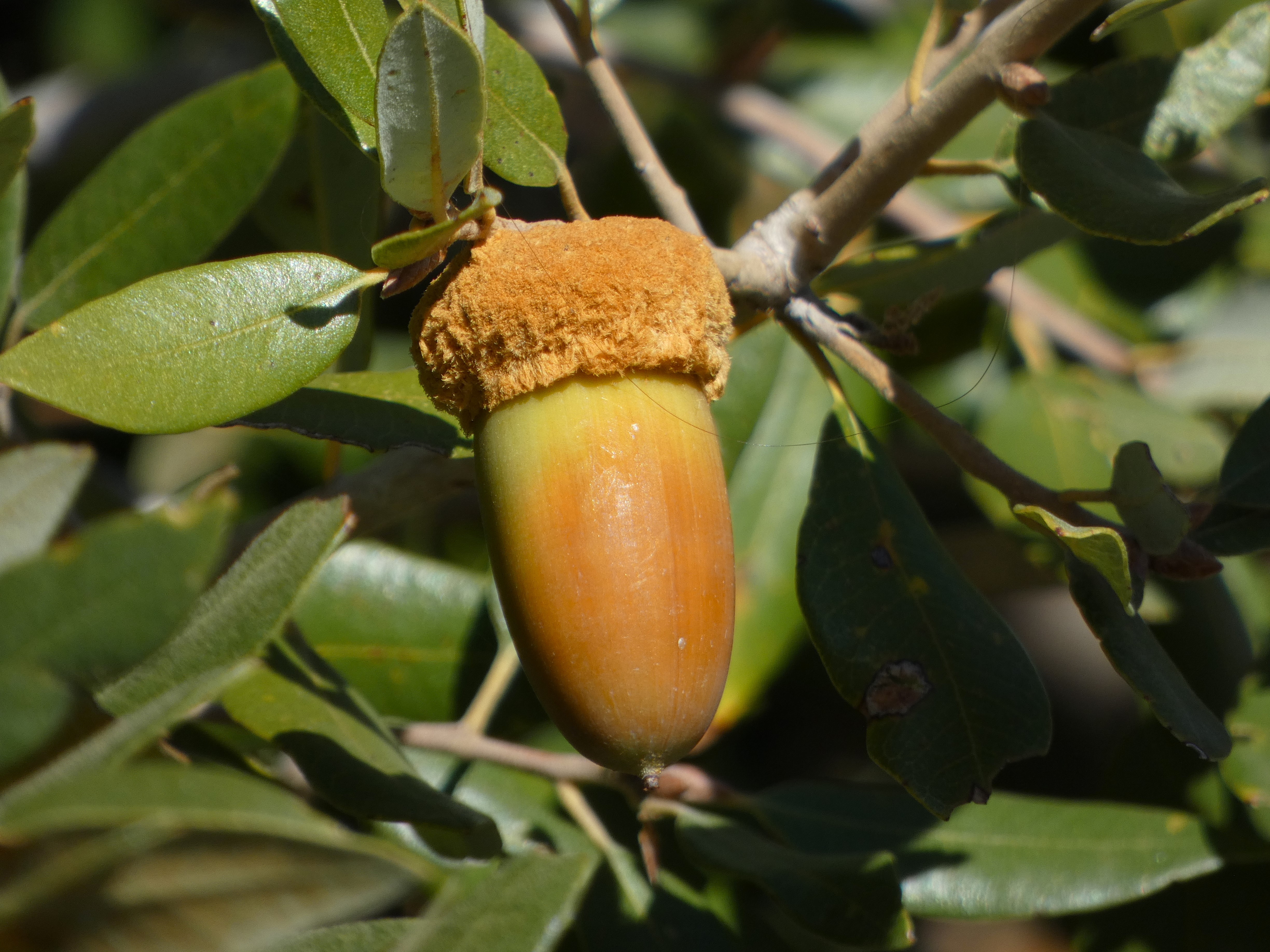
Closer at hand were a lot of ripening acorns. The bears and woodpeckers will be happy.
We reached the valley floor and started our tour of Yosemite's greatest hits. We were surprised to find some wispy curtains of water flowing over Bridalveil Falls. The 620 foot-high waterfall is a classic example of a glacial hanging valley. The main trunk glacier flowing through Yosemite Valley was able to erode a much deeper trough than the small glacier in Bridalveil Creek, so the floor of the creek was left hanging high above the main valley floor.
It was not a cold day, mostly in the sixties, but the sun was intense. It brought out what colors there were in the oaks and dogwood trees.
We didn't see a great many varieties of birds, but there were some Acorn Woodpeckers busy collecting acorns and hiding them in tree "granaries". Such trees can have tens of thousands of drilled holes that can hold a single acorn each. The birds live in loose family groups who search for and guard their food supplies.
Yosemite Valley is not a 'typical' glacially-carved valley. Most such valleys have a U-shaped profile, and are relatively straight. Yosemite Valley is characterized instead by bold cliffs that extend out into the valley with dark recesses in-between. This is the result of having eight distinct intrusions of granitic rock, ranging in composition from 'true' granite to granodiorite, tonalite, and diorite. They differ from each other in the proportions of the minerals quartz, potassium feldspar, and plagioclase. They also vary in the amount of dark minerals they contain including biotite mica, hornblende, and a little augite. They also vary in their pattern of fracturing (jointing), and this is expressed in differing vulnerability to erosion by ice, water, and mass wasting (landsliding and rock falls).
Sentinel Dome (above) is a good example. It is composed of fairly resistant Sentinel granodiorite, but it is jointed and thus forms a somewhat narrow high cliff that looms over the valley.
Yosemite Point on the other hand is composed mostly of unjointed El Capitan granite and forms a wide bold cliff. Sometimes people sort of 'miss' this incredible cliff because much of the time there is a stunning waterfall pouring off the west flank of the precipice (the dark mark on the left side in the picture below). That waterfall is only fifth or seventh highest waterfall in the world, and is known by the moniker of Yosemite Falls, measuring in at 2,425 feet. It wasn't actually dry today, but one needed binoculars to see the small trickle at the top of the cliff.
The autumn season is one of the best times to view Half Dome from the middle of Sentinel Bridge. The Merced River is flowing at a low ebb and the still waters make for memorable reflections. Half Dome is another example of an unjointed monolith of granitic rock called the Half Dome granodiorite. It is the youngest of the igneous intrusions exposed in the valley, with an age of about 84 million years. The Sentinel granodiorite is about 88 million years, and the El Capitan granite around 103 million years. These dates fall within the Cretaceous period, which means that when these molten masses were intruding the crust, there were dinosaurs wandering the surface four or five miles above. The dinosaurs would have experienced occasional volcanic eruptions when some of the intruding magma escaped to the surface.

In the years since, erosion has removed the miles of overlying rock and dumped it into the Central Valley or the waters off the coast of ancient California. The region seems to have been eroded to a low elevation landscape that was later uplifted to form the modern Sierra Nevada.
We wandered around Cook's Meadow and stopped into the store at Curry Village to replenish my t-shirt collection. The sun was starting to get low, so we made our way west to our favorite evening viewpoint, Valley View.
Valley View is almost a secret to Yosemite visitors because it has a small parking lot (maybe room for ten cars) at a blind curve so that if you are in the right-hand lane you might miss it. Since the road is one-way at that point, you would have to repeat a five mile loop to get back. The small parking lot is a blessing because it limits the size of the crowd. It's a quiet spot to enjoy the fading light on the cliffs of El Capitan and the Cathedral Rocks. The river usually flows slowly here making for memorable reflections of the cliffs above. We enjoyed the few moments of peace, and then headed home.
And that's the way it was today...
 

Monday, September 19, 2022

The Other Yosemites: The Treasured Valleys of the Sierra Nevada

"Yosemite is so wonderful that we are apt to regard it as an exceptional creation, the only valley of its kind in the world; but Nature is not so poor as to have only one of anything. Several other yosemites have been discovered in the Sierra that occupy the same relative positions on the Range and were formed by the same forces in the same kind of granite." John Muir, The Yosemite, 1912 
It may very well be that there is no place on Earth quite like Yosemite Valley. Few places can combine such dramatic cliffs and peaks with impossibly high waterfalls and deep forest glens. It remains one of my favorite places to visit, and it is one of life's great pieces of luck that I live only a 90 minute drive away. I go whenever I can. 


There is, however, an unfortunate truth of Yosemite Valley: here, like at Arches, Zion, Glacier, Yellowstone, and Grand Canyon, we are loving our national parks to death. The crowding in Yosemite Valley can be abysmal, only relieved to some small extent by the rationing of entrance reservations. I remember the nightmare of visiting the park on a Labor Day weekend (the family members who were seeing it for the first time could only get away at that time). We spent nearly the whole time in a traffic jam, finally scoring a parking spot at Curry Village for a while. And then a long traffic jam getting back out of the valley. The family with us treasured the experience of at least seeing the soaring cliffs, but really, this is no way to enjoy our national treasures.  

When it comes down to it, we have a choice. We can continue to ration these precious places more and more, or we can expand the idea of what is spectacular and convince people that there are places of awe that can also be places of serenity and wonder. Without the crowds. John Muir, one of Yosemite's greatest fans, understood this well. In his writings, he was constantly reminding us that the Sierra Nevada is full of spectacular canyons, which he called the "other yosemites".

Source: Herbert Gleason (1920s), in Wikipedia
One of those places is so remote that I expect that I will never have the chance to see it personally. I'm a bit too old I think to make the long trek of 10-plus miles followed by a precipitous plunge down thousands of feet of switchbacks into Tehipite Valley on the Middle Fork of the Kings River. And it doesn't have just a half a dome; it has a whole one, Tehipite Dome, which towers 3,500 feet above the forested valley floor.

Amazingly, the valley was proposed as a site for a reservoir despite its remote location. When Kings Canyon was made a national park in 1940, Tehipite Valley was purposely left out of the park boundaries on the expectation that the dam would be built. It wasn't until 1965 that the valley was incorporated into the park.

Source: Grand Canyon of the Tuolumne, by Matt Hoffman through Wikipedia

I have stood at the portal of one of the other yosemites, the Grand Canyon of the Tuolumne River. When I was a teenager, my family backpacked to Glen Aulin Camp at the upstream end of the gorge, but we didn't go any further downstream. I still have hopes of hiking out to the rim of the canyon from White Wolf in Yosemite.

The canyon is as deep as the Arizona version of the Grand, but could hardly look more different. The canyon has been shaped by the longest most extensive glacier that ever existed in the Sierra Nevada. While Yosemite is famous for high waterfalls that leap from the canyon rim, the Tuolumne is noted for the large waterfalls on the Tuolumne River itself, especially Waterwheel Falls, where the river leaps upward into the air during periods of high flow.


One of the most famous "other yosemites" was Muir's most treasured valley, Hetch Hetchy, which is downstream of the Grand Canyon of the Tuolumne. Parts of Hetch Hetchy bear a startling resemblance to Yosemite, with a rectangular cliff that resembles El Capitan, and a pair of stunning waterfalls, Wapama Falls, at 1,080 ft (330 m), and Tueeulala Falls, at 840 ft (260 m).
Unfortunately, Hetch Hetchy was deemed an ideal spot for water storage, and after a protracted political battle in 1914, O'Shaughnessy Dam was built and flooded the entire valley floor under 300 feet of water. It was at the time within the boundaries of Yosemite National Park. Muir's heartache over the loss was said to have contributed to his death. 
Access is much easier at Hetch Hetchy, as a paved road reaches the valley and dam from the Big Oak Flat Entrance to Yosemite National Park. There are trails that reach the base of the waterfalls and on into the backcountry, but Hetch Hetchy receives a very small fraction of the visitation that Yosemite gets. It should have been different. There are constant calls for the dismantling of the dam, but it would be decades before the valley could become what it should be. When I photograph the valley, I tend to crop out the lake...
John Muir wrote of another yosemite in a magazine article in 1891:
In the vast Sierra wilderness far to the southward of the famous Yosemite Valley, there is a yet grander valley of the same kind. It is situated on the south fork of King's River, above the most extensive groves and forests of the giant sequoia, and beneath the shadows the highest mountains in the range, where the caƱons are deepest and the snow-laden peaks are crowded most closely together. It is called the Big King's River CaƱon.
Today we call it the South Fork of the Kings River, and the valley floor Cedar Grove. It is more accessible than all the others, with a paved highway, four or five campgrounds, and a small resort and store. But most importantly, it offers a quiet experience in a spectacular setting. I've rarely seen crowds here, although I'm sure it happens. But never on the scale of what goes on in Yosemite Valley.
There is a network of trails throughout the valley, and trailheads lead into the alpine country above (some of them insanely steep). But most of all, it offers high granite cliffs that tower over the valley floor. They aren't the same as Yosemite's cliffs, nor should they be. But they are just as high and are truly awesome in their own right.
It's a sad commentary on human values that this incredible valley was also slated to become another reservoir, and like Tehipite Valley it was left out of the boundaries of the new Kings Canyon National Park in 1940, and was not added to the park until 1965. Because of this wise decision, we have a beautiful alternative to the crowded madness of a summer day in Yosemite Valley.
Come and see Yosemite Valley, of course. It is the experience of a lifetime. But give yourself some time to see the other less famous yosemites. If you can, walk to the remote valleys. Take lots of pictures for the benefit of those who can't (I would love to post an entire blog entry of anyone's journey into Tehipite Valley). You won't be disappointed, and all you'll miss is the traffic and the unruly masses of humanity.


Friday, March 25, 2022

A Tale of Two Pullouts: Yosemite Valley From a Different Angle

El Capitan and the Merced River from the east

I know that I am truly privileged living as I do only a two-hour drive from one of the most sublime places on Earth, Yosemite Valley and the Sierra Nevada. We head up there two or three times a year, sometimes with students in tow, and sometimes on our own, so in 30+ years we've been there at least 100 times.

And I never get tired of it.

Part of the allure is seeing the seasonal changes. Winter provides the coating of snow, while fall provides the changing colors of foliage. Spring offers surging waterfalls and wild river flows. Summer provides...well...crowds, but also nice moments in places we learn of where the crowds can be avoided. We have favorite meadows and lakes for instance where people rarely stop. No matter when or where we visit, there always seems to be something new or different.

The Cathedral Spires are tucked away on the east side of the Cathedral Rocks at Bridalveil Falls
I know how it is if one gets to see Yosemite Valley for the first, and maybe only time. I've had that experience at so many other places around the world. The time available may be very limited, one may be part of a tightly controlled tour, and no one wants to miss any of the most famous views or hikes. And so it is that there is the required stop at Tunnel View, Bridalveil Falls, Cook's Meadow for the view of Yosemite Falls, and maybe Ahwahnee Meadow for a view of Half Dome. The walk to Lower Yosemite Falls, or Nevada Falls. And the Visitor Center. It makes for a full day, and a fulfilling day too. One of the most spectacular days you might ever experience.

And I never get tired of it. I'm perfectly happy to hit those same spots on my 101st trip to the valley. The season, the time of day, and the weather all conspire to make each stop a unique experience of wonder. But sometimes there are changes of a different nature, and that makes some trips really memorable. That is what today's collection of views is about.
Sentinel Rock rises above the south side of Yosemite Valley across from Yosemite Falls
Since the time that Yosemite Valley became a park, suppression of all forest fires has been the official policy. It was not however the natural condition of the parkland, nor was it the normal condition of the valley floor over the last few thousand years when it was managed by the original inhabitants of the region. 

The Ahwahnechee people, with roots among the Miwok and Paiute peoples of both sides of the Sierra, depended in large part on the acorns of the Black Oak and grazing animals like deer or bighorn in Yosemite Valley. It was in their best interest over the centuries to allow fires to burn through the valley floor and hold the quick-growing conifers at bay. When the park administrators put an end to the fires, the pine and cedar trees choked out meadows (only 65 acres of the original 750 acres of meadows remain) and grew into impenetrable thickets, blocking views of the canyon walls above.

What's worse is that choking off small fires can cause a buildup of fuel in the forest that could only lead to much worse fires than usual. This was always a danger, but it is far more hazardous today in a time of warming climate and extended droughts. Every Californian is fully aware of how wildfires in the state have morphed into monstrous events without parallel in written history.

The National Park Service has come around in their fire philosophy, especially after extensive fires a few decades ago in Yellowstone and Mesa Verde National Parks. They have instituted new policies of prescribed fires and selective tree removal to make the parks safer, but also to enhance the experiences of park visitors. In what way? The views.
The distinctive profile of the Three Brothers is the result of parallel jointing, or fractures in the granite that occur as the rocks are exposed by erosion
There are the parking lots that attract the majority of park visitors, but on the roads that loop around the valley there are many small pullouts, enough for perhaps three or four cars. In years past there seemed no real purpose for them, as they were surrounded by thick forest and offered no views or trailheads. On our visit a week ago, I found that two of those previously uninteresting pullouts had had the forest thinned out, and that they now possessed some outrageously spectacular views! The familiar iconic cliffs were there, but from angles I had never really seen before. In particular there was the long vertical cliff extending east from El Capitan, a view of the rarely seen Cathedral Spires (as opposed to the Cathedral Rocks at Bridalveil Falls), the vertical pillar of Sentinel Rock (often missed by people staring at Yosemite Falls), and the Three Brothers, which have never really had a designated viewpoint and are usually hidden by the tall trees. Upper Yosemite Fall was visible as well, perhaps farther away, but how many of you Yosemite veterans can recall seeing the falls with not a single other person in sight?
Yosemite Falls from a pullout west of Swinging Bridge
We had a leisurely lunch at the pullouts and wandered about taking pictures, and only two or three cars pulled off the road, and no one else actually got out. Except for the noise of passing traffic on a crowded Sunday afternoon, we literally had the best of Yosemite Valley to ourselves.
Prescribed fire in Yosemite Valley, with Half Dome and Clouds Rest in the distance.
We stayed at the park through Monday morning, and when we stopped by Tunnel View we witnessed another chapter in the new fire/forest regime: the ignition of a prescribed fire. It was done in March because the ground was still damp enough to prevent the uncontrolled spread of the fire. If you are on Facebook and would like to know more about forest management in Yosemite, check out (1) Yosemite Fire and Aviation | Facebook.


Monday, March 14, 2022

The Merced River of California: A Place for Wildflowers and Landslides (and Yosemite Valley)

The Merced River is one of California's extraordinary waterways. First and foremost, it is the river that carved Yosemite Valley, which is one of the world's most spectacular valleys. You may be forgiven for thinking that glaciers carved Yosemite Valley, and they certainly had an important role, but it was learned years ago that the heavy-duty work of carving the 3,000-foot-deep gorge was done before the ice ages ever arrived 2 million years ago. The glaciers certainly modified the shape of the valley, but the depth was first achieved by water flowing over stone.

We spent a couple of days in the valley at a time when the crowds are few, the snow is in retreat, but the green of spring is still some weeks away. It was neither winter nor spring, but the waterfalls were full and the birds were becoming more active, and we had a marvelous time. This morning brought a sight we had never seen in dozens of previous visits though: the beginning of a controlled burn. 

The native Americans who first lived and hunted in the valley knew the value of fire. They would regularly set fires to the forest and meadows to clear out undergrowth and maintain the extensive meadows on the valley floor. When the park was established in 1890, fire became the enemy and any hint of a fire was quickly put out. As a consequence the meadows shrank from the original 750 acres to less than 100 today. The forest became choked with young trees, and fuel built up on the forest floor. It was a major disaster-in-waiting. In recent years, the park management has sought to return the valley floor to something resembling the environment that existed prior to European colonization. Some of the activity has involved some controversial logging operations, and the controlled burns can interfere with the experience of visitors, but the eventual changes will be a vast improvement over present conditions.
One of our real motivations for the trip actually involved a different part of the Merced River, the deep canyon downstream of Yosemite Valley. The Merced River canyon downstream of the lowest extent of the glaciers is a different place entirely. The vertical walls of glacially-shaped granite give way to a V-shaped river valley covered by vegetation that often obscures an extensive belt of metamorphic rocks that are hundreds of millions years older than the granite intrusions.
While not as "spectacular" as Yosemite Valley, the canyon is not without scenic wonders. Indeed, for a few weeks in the spring the walls of the canyon can explode into a color palette that puts the gray granite cliffs of Yosemite Valley to shame. Wildflowers like golden poppy, lupine, and fiddleneck and many others can cover the slopes from the river to the canyon rim.
The climax (if it comes; it's been a dry year) lies a few weeks in the future. But here and there, the slopes provided a hint of what is to come.
The redbuds are just getting started with their not-red buds. More of a pink/purple shade if you ask me.
The slopes of the gorge are also an environment adapted to fire. In the Mediterranean climate the winters are cool and wet, and the summers are very hot and dry. Fires have always swept through the gorge, but those of recent years have been particularly intense due to the extended droughts and higher temperatures due to global warming.
Ultimately fires are a necessary part of the environment, but they can seem particularly tragic in the short-term, especially when people are killed or developments destroyed. The wildflowers play an important role in the recovery of the slopes, as they are pioneer species that help rebuild nutrients in the soils that can assist in the return of the shrublands and forest. The seed may lie in the soil for years before conditions are right for germination, and then the barren slopes come alive with color.
The Golden Poppy is a particularly visible part of the wildflower population. It is California's state flower, and it was a great choice because it thrives in many if not most of California's diverse ecosystems. They're common in the Coast Ranges, the Great Valley, the Sierra Nevada foothills, the volcanic landscapes of the Cascades and Modoc Plateau, the mountains of southern California, and in the Mojave Desert (the Antelope Valley Poppy Reserve is spectacular right now, from what I am hearing). They can also grow on California's strange serpentine soils that most plants cannot tolerate.
A final sight were looking for was the Ferguson Slide. The slope at this particular turn in the river was always unstable, but in 2006 the entire slope slide downwards and covered the highway with tens of thousands of cubic yards of boulders. Far more debris remains on the slopes above, and for a time there were fears that a truly massive slide could block the river and form a natural dam with a lake several miles long. A number of "fixes" were considered, and in the meantime "temporary" bridges were built to provide one-way access on the busy highway. Temporary in the sense that they have been there for fifteen years and counting.
In the end they have decided to build an "avalanche shed", but for rocks instead of snow. The cost is in excess of $180 million (which at the time was about the entire budget for Yosemite National Park). Nature doesn't take kindly to attempts at altering the physics of the slope, and some of the first attempts at stabilizing the upper slopes were laughably sloughed off. There was an earlier coating of the fencing material that was destroyed soon after application. They spent several years carting off nearly 150,000 cubic yards of metamorphic rock and have again tried to fence in the slope. It will be interesting to see what happens when the construction of the shed actually begins.
The photo above is the most comprehensive picture I've been able to capture. I made sure to be last in line when the traffic light changed and allowed the line of cars to follow the one-lane road. I lingered a few seconds to get the shot, and hurried along to make sure I didn't run into oncoming traffic on the narrow bridge. 

There are many more stories to tell of the Merced River downstream, where it flows through the Mother Lode, the places where it lies trapped in the waters of Lake McClure and Lake McSwain, the dredge pits at Merced Falls, and the slow journey across the floor of the Great Valley where it ends in the San Joaquin River. Those will come another day!