Showing posts with label Yosemite Falls. Show all posts

Saturday, April 12, 2025

Do You Think You Know the Highest Waterfall in Yosemite Valley? You Could Be Wrong!


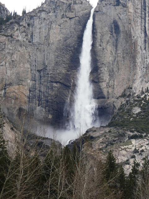
Quick quiz: What is the name of this waterfall?
What is the highest waterfall in Yosemite Valley? Depending on the parameters one can use to determine "height", your assumption may be wrong! Most "authorities" recognize Yosemite Falls (2,425 feet/739 meters) as the highest in Yosemite Valley and North America, and somewhere around the fifth or seventh highest in the world. But it depends on how you decide to measure waterfalls. By a different metric, Yosemite Falls isn't even the highest waterfall in Yosemite Valley. It's the word "falls", in the plural, that makes the difference.

I was in Yosemite Valley yesterday, and the falls were flowing strong. There is no doubt that Yosemite Falls is one of the most stunning sights on the planet. A chance movement of a glacier 13,000 years ago forced a middling stream from its old channel to the left of the current waterfall, forcing Yosemite Creek to drop right off the edge of the sheer cliff. You can see the old channel almost hidden in the shadows in the photo above.
The fall makes a sheer plunge of 1,430 feet (440 meters) at the Upper Fall and then cascades through a series of steep ledges called the Middle Cascades for 675 feet (206 meters). There is a final drop of 320 feet (98 meters) at Lower Yosemite Fall. The Middle Cascades are generally hidden from view unless you hike the steep trail up to the top of the falls (below).
Part of the Middle Cascades (April 2003)
But if one decides to be a purist about such things, one can define a waterfall's height on the basis of the greatest freefall. By that metric, Yosemite Falls still is an imposing 1,425 feet (739 meters) high. But it also means it's not even the tallest waterfall in Yosemite Valley.

Many first-time visitors to the valley are drawn to Bridalveil Falls (620 feet/189 meters) because it is the first major waterfall visible as one enters the valley. But when standing at the base of Bridalveil, they may see another high waterfall across the valley west of the sheer cliff of El Capitan and wonder if it is Yosemite Falls. It's not. It's called Ribbon Fall, and it has a single drop of 1,612 feet (491 meters). That's nearly 200 feet higher than Upper Yosemite Falls (it's the one in the picture at the top of the post). It is less familiar than many of the other waterfalls because it is usually dry by June when the majority of people visit the park. But if you get the privilege of seeing by visiting in the spring, you are in for a treat.
Ribbon Fall (1,612 feet) to the left with the 2,900 foot cliff of El Capitan to the right

Ribbon Falls is one of many treasures that make a spring visit to Yosemite Valley a worthwhile endeavor. If you want to see another springtime waterfall over a thousand feet high, check out Sentinel Falls.

Friday, September 15, 2023

A California Love Letter: It's the Best Geology to be Found Anywhere!

This is the second of some resource materials I have on our college website that are being removed, so I wanted to preserve them. The following is some info I give to my students of my "Geology of California" course. For the majority of these students, it is their first introduction to geology, and their first introduction to the extraordinary state that is their home. For a more complete explanation of each superlative, click on the orange links (down the rabbit hole!). Enjoy!

Highest point in the lower 48 states: Mt. Whitney, 14,505 feet 

Lowest point in the western hemisphere: near Badwater, Death Valley, -282 feet

The deepest canyon in North America (maybe): Kings Canyon, Giant Sequoia National Monument. Hells Canyon on the Oregon/Idaho border may be 19 feet deeper. Maybe...

Largest living things in the world: Sequoia Trees

Tallest living things in the world: Coast Redwoods

Oldest living things in the world: Bristlecone Pines (5,000 years), White Mtns, or Creosote Bushes in Colorado Desert (11,000 years)

My Scottish BBC Interview at a relatively balmy 110 degrees

Hottest Place on the Planet and Driest Place in North America: Death Valley: 134 degrees, precipitation 1.4"/year

One of the Snowiest Places in the U.S.: Tamarack, Sierra Nevada, 76 feet in one year, 32 feet in one month, 37 feet on ground at one time

Highest Waterfall in the North America (no. 7 in world): Yosemite Falls, 2,425 feet

Second tallest active volcano in the U.S.: Mt. Shasta, 14,162 feet

Second most recently active volcano in lower 48 states: Mt. Lassen (1914-21)

Most voluminous volcano in the lower 48 states: Medicine Lake Highland (around 130 cubic miles) in northeastern California

Scarp from the 1872 Lone Pine earthquake

Some of the largest earthquakes in the lower 48 states: 1906 (San Francisco 7.8), 1872 Lone Pine (7.8), 1857 (Ft. Tejon 7.8)

Old oil derrick near the Santa Clarita Valley

One of the more prolific oil and natural gas producing regions in the world: Los Angeles Basin, Bakersfield, and Santa Barbara-Ventura Channel

One of the biggest explosions ever: Long Valley Caldera, 750,000 years ago, 125 cubic miles of ash spread all over the western states as far east as Nebraska and Kansas

McWay Falls at Julia Pfeiffer-Burns State Park on the Big Sur Coast

No other state has the combination of landscapes: Coastlines, deserts, mountains, river valleys and plateaus, due in no small part to the fact that California is influenced by all three different kinds of plate margins: Divergent, convergent and transform. Few places in the world have this kind of diversity.

The San Andreas fault on the San Francisco Peninsula. San Andreas reservoir, from which the fault took its name, is in the foreground.

What would you add to this list???

Wednesday, August 4, 2021

A Different Kind of "Other": Yosemite of the Pandemic

Half Dome from Sentinel Bridge
I've spent a fair amount of time writing about "The Other California", the spectacular places we have in our state that don't tend to show up on postcards. But sometimes there are decent reasons to visit the places that are on the postcards. This is especially true with Yosemite Valley and Yosemite National Park. There are few places on Earth as spectacular as the granite cliffs and towering waterfalls. But summer isn't that time. It's hot and dusty, the waterfalls are dry or nearly so, and the crowds and traffic are...simply awful. It's my least favorite time of year.

But sometimes events conspire. A pandemic continues to rage across the country in large part because a significant proportion of the population refuses to mask up or get a vaccination. As a result, the National Park Service instituted a reservation system at Yosemite National Park, limiting the number of daily visitors. And despite the desperately dry conditions caused by the intense drought, there were a number of monsoon-related thunderstorms in the High Sierra in the last few weeks. Mrs. Geotripper and I decided to give the valley a chance, so I carefully watched the reservation site (recreation.gov) and caught a cancellation. We headed up the hill on Monday. 

The view from Swinging Bridge of Yosemite Falls
It was a different world in Yosemite Valley. Two years ago we paid a visit on Labor Day weekend (our out-of-town visitors couldn't come any other time), and it was absolute mayhem. There was an hour-long wait at the entrance station, and a two-hour long traffic jam that resulted in a single parking spot for the day with no chance for exploration (the trams were stuck in traffic too). But Monday there was no waiting to get into the park, and there were parking spots available everywhere, even the ones usually most impacted, like Swinging Bridge, and Sentinel Bridge. The weather was warm, verging on hot, but the ground was moist, the meadows still green, and Yosemite Falls was flowing. It was the kind of day that every visitor to this beautiful place deserves, and it was the kind of day that had become exceedingly rare in recent years.

There is usually a gaggle of photographers standing on Sentinel Bridge (the top picture) because of the artful possibilities of catching the reflection of Half Dome on the Merced River. We had the bridge to ourselves. Swinging Bridge (which for the record does not swing) was crowded as always, but even there the bridge was empty for a few moments and I was able to score a shot of Yosemite Falls without the aforementioned crowds in the picture.

There are lesser-known viewpoints like the one above of the Cathedral Rocks and Cathedral Spires, and on most days the three parking spots are taken. But once again we had the pullout to ourselves, and got a wonderful view of these cliffs that would qualify for national park status in any other place, but which barely catch the attention of travelers on their way out of the valley.

Another crowded spot on a normal day is Valley View at the west end of the valley. The small parking lot is usually packed, but once again there were spots available. El Capitan (left) and the Cathedral Rocks and the wispy, nearly invisible Bridalveil Falls (right) reflected on a slow-moving stretch of the Merced River.

I was going to write about the need to come to Yosemite on a weekday if at all possible, but it occurs to me that a better discussion is whether to implement a reservation system permanently. The concessionaires and surrounding communities of course depend on as many visitors as possible to thrive and maintain their profit margins. But the quality of the experience of visitors is radically diminished when they spend most of their time waiting in lines and being jostled by crowds on the trams and the trails. People expect that sort of thing at an amusement park, but that's not what our national parks were meant to be. Consider the mission of the parks: to preserve unimpaired the natural and cultural resources and values of the National Park System for the enjoyment, education, and inspiration of this and future generations. That simply doesn't happen in our most popular parks like Yosemite, Zion, Arches, and others that are bursting at the seams with tourists.

Our park system has not expanded with our population, and the budget of the park service is cut seemingly every year. The last administration actually cut the size of a number of precious parks. We need to expand the opportunities of people to experience the parks in the best way possible. 

Monday, May 17, 2021

Yosemite Valley This Week: A Moment of Spring Richness and an Uncertain Future


I admit it. I fear what lies ahead. That's not the usual opening statement in a photo-essay of Yosemite Valley at its best moments. But that's the problem. I was there last week, when the heaviest snowmelt should have been weeks in the future. And the valley was at its best, a lovely escape from the summer-like heat of the Great Valley downstream.
But the peak runoff is not weeks in the future. It is probably already past. This year's snowpack was an unmitigated disaster. The few storms that did come dropped a bit of snow, enough in some years to get by, but very warm and dry conditions during April dropped the snowpack to around 5-10% of normal, or what passes for normal in these uncertain times. The snowpack would usually keep the famous waterfalls busy until mid-June or even July, but many of them may be dry within a few short weeks. And then the fires will come. I don't know what lies ahead for this most beautiful of valleys, but a disastrous fire has to be considered as a possibility.
The natural condition of the floor of Yosemite Valley has always been controlled by wildfire. Lightning strikes have caused fires for thousands of years, leaving the valley floor as a patchwork of open meadows with a few mature oaks and ponderosa capable of surviving the occasional grass fires. When humans first discovered the valley thousands of years ago, they continued the practice of burning the valley floor every few years. They had their motives of course; the acorns of the fire-resistant Black Oaks provided much of their diet, and the hunting of game was easier when the prey was in an open meadow rather than a deep forest.
When the valley was "saved" by turning it first into a state park in 1864 and later into a national park in 1890, fire suppression became the governing philosophy. The park's original 745 acres of meadows were invaded by young saplings and the 65 acres of meadows today represents only 7% or so of their original extent. It didn't help that drainage outlet of one of the wetland areas was dynamited to keep down the mosquito population.
Much of the valley floor has become a thicket of young and unhealthy conifer trees, a fire hazard of the highest order. The park service has come around to accept the need for fires in the management of the valley, but their success has been spotty and controversial. Prescribed fires have been done in some areas of the park, but more than one has gotten out of control and damaged structures. And prescribed fires are done when soil and fuel conditions are on the wet side. That is not the case at Yosemite this year.

An alternate practice was begun around a decade ago, and it too has been controversial. Instead of burning, the park service has been allowing tree-cutting to be done in some areas to remove the unhealthy trees. The buzz of chainsaws does not seem compatible with the general notion of "preserving" natural lands, but it may be a necessary evil. It led to an unexpected change for me as we visited the park last week.

Everyone always seems to be in a hurry as they scurry through the park looking for parking spots. The traffic was a problem because the free park shuttles weren't running due to the pandemic. So to see the many features of the valley, one had to park and hike quite some distance, or else drive from parking lot to parking lot looking for a good view. I was letting traffic pass by pulling into roadsides that normally don't offer much in the ways of views. But this time was different.
A lot of trees had been cleared from a pullout that I knew had never had much of a view before. No one else was there, but as I got out I could see something was different. The rocks above were, well, unexpected. I've struggled at times to get an interesting angle on the Cathedral Spires (above), but they were easily visible. And as I turned, I realized the Three Brothers were also in the open (below). 
And as I turned yet again, I had a full-on view of El Capitan that showed the full expanse of the cliff from the "Nose" to Horsetail Falls. The sawn-down trees in the foreground were perhaps a sad mess (that will be cured in time by natural forces of decay), but the view of the cliffs was dramatic and quite unexpected. We sat in the pull-out and enjoyed a quiet lunch.
The Pacific Dogwoods were in full bloom. The trees are a somewhat nondescript part of the understory for much of the year, but during the spring the flowers are dramatic (and for the biologists among you, I know that the big white petals are actually modified leaves or bracts, and that the true flowers are in the "button" in the middle). 
Our journey through the valley was our first in nearly a year. It included a stop at one of the most congested spots, but as is always true, there was a reason for its popularity. The Tunnel View is close to the spot where European colonizers first viewed the valley in 1851. The party, a militia trying to chase down a group of Ahwahnechee people, was largely unimpressed with the valley. But their medic, Lafayette Bunnell, was deeply moved by the sight, and later interviewed Chief Tenaya and others to learn what he could of the valley. He is credited with the names of many of the features, including the name of the valley itself. Yosemite seems to have been a derivative of the Miwok name for Grizzly Bear. Their actual name for the valley was "Ah-wah-nee".
So a hot and dry summer season looms. I hope for the best.

Monday, September 9, 2019

The Way It Was: Yosemite on a September Saturday

Not what I was expecting...

I generally avoid Yosemite Valley in the summertime, and I try to avoid Saturdays especially, but I was a glutton for punishment; we hadn't been to the valley since last spring and were kind of curious about how it would be. We expected crowds and dryness and dust.
That's not what we found. In September, the meadows are often brown and the waterfalls dry. Instead, Bridalveil Meadow was green and filled with wildflowers, and Bridalveil Fall, while not roaring by any means, was flowing nicely. The wind occasionally picked up and blew the water in odd directions.
Even Yosemite Falls had a trickle. I don't know if it was left over from the spring, or if it was from the recent thunderstorms, but it was nice to see.
Half Dome is spectacular, no matter the time of year. The afternoon cumulus cloud buildup provided a nice backdrop.
Sentinel Rock is another towering cliff that is an incredible sight no matter the season. It's one of those rocks on the "wrong" side of the valley that is not noticed as often because it is opposite of Yosemite Falls. If it were anywhere else on the planet besides Yosemite, it would be a national landmark all on its own.
A late afternoon treat is the Valley View at the west end of Bridalveil Meadow. There's a small pullout, but it is often ignored by people rushing home from their day in the valley. We found a spot despite the traffic, and simply sat for awhile.
The wonderful thing about late summer is that the low water on the Merced River is often calm and provides a wonderful reflective surface. It was gorgeous and serene.

And that's the way it was...

Saturday, April 13, 2019

The Way it Was Today: Spring is About to Burst Forth in Yosemite Valley

In certain ways, I am the luckiest of people. I live in a place, however humble, that is a mere two-hour drive from Yosemite Valley in Yosemite National Park. I can visit and explore the park almost any time I want to, and I do so as often as I can. This is a privilege that I could never take for granted. It's just to precious to me.
A related form of luckiness is that I am a teacher, a professor of geology. That means that I have also been granted the wonderful privilege of introducing Yosemite to my students, a great many of whom have never visited the park despite their proximity. That's what I got to do today, teaching a field course on the geology of Yosemite National Park. Among the students on the trip, there were half a dozen who had never ever laid eyes on the park. The sparkling clear spring day did not disappoint.

We started our exploration of the valley with the glorious panorama from Tunnel View (top photo). We could see El Capitan, Half Dome, Sentinel Rock, the Cathedral Rocks, and Bridalveil Falls. It is hard to imagine another place in the world with such imposing cliffs and towers in such a small confined valley. We talked about the discovery of the valley by people, both thousands of years ago, and in the last 170 years by the usurpers and colonizers of this incredible landscape.

We then drove to the parking area on the valley floor where we could look at El Capitan in one direction, and Cathedral Rocks and Bridalveil Falls in the other. We were able to talk about hanging valleys in the presence of one of the greatest examples in the world. We also talked about how Yosemite Falls the 5th or 7th highest in the world, and yet is not even the tallest waterfall in Yosemite Valley.
Ribbon Falls at Yosemite Valley
Yosemite Falls is certainly a spectacular sight, but to purists of such things, it is actually three waterfalls, an upper fall with a height of 1,425 feet, a middle cascades section with a drop of more than 700 feet, and a lower drop of 320 feet. There is another waterfall in Yosemite that is 200 feet higher than upper Yosemite Falls. It's called Ribbon Fall and it falls over the cliff to the west of El Capitan. It is not as well-known as Yosemite Falls because it is usually dry by the early summer when most tourists come to visit.
Just the same, Yosemite Falls is a true treasure, leaping from a sheer cliff and impacting on the rocks below. It's the 'accidental' waterfall of Yosemite Valley. Yosemite Creek once flowed down the steep channel to the left of the present-day falls, but the course of the creek was reconfigured by the movement of glaciers across the mouth of the older creek, forcing the river to find a new path over the brink of the cliff.
The vantage point offered a peek-a-boo of Half Dome. This iconic monolith towers nearly 5,000 over the valley floor. It is the product of several processes acting in concert. The first is unloading, the release of pressure by being brought to the surface of the earth. The rock expands just a bit, but then fractures. Vertical fractures are called joints, and jointing is the explanation for the steep face of the dome.
The second form of fracturing is called exfoliation, a process by which the rocks split into slabs that are parallel to the surface of the rock. This has the effect of removing corners and edges, leading to the shaping of the dome..

That is the gist of our day, but more than anything else, I wanted to share the images of the day with all those who can't easily get there. It was a stunning day in the falley.