Showing posts with label Drought. Show all posts

Tuesday, December 28, 2021

A History of the Drought in Three Pictures.


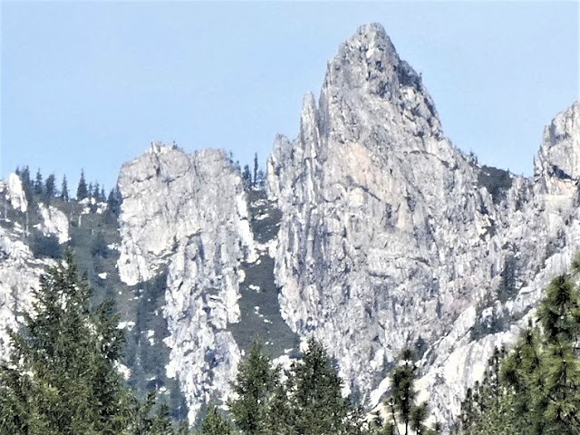
Castle Crags on December 27, 2021
It's nice to be able to report some good news once in a great while. Global warming models for California paint a truly depressing picture going forward of crippling droughts, failing snowpacks, and many tough choices to make regarding water use. We've been living those models for the past few decades with a five-year drought ending in 2017, and one of the worst drought years in history just last year. We are coming to depend more and more on the occasional intense atmospheric river events to fill reservoirs in preparation for the dry years. They've been in short supply in recent years.

My family-related travels have encapsulated the story of California's precarious water situation. The pandemic had prevented many forays north to Oregon and Washington, but we managed a trip last April, and we just completed a rather harrowing trip today. These trips were a lesson in contrasts.

We always try to take a break at Castle Crags State Park near Dunsmuir and Mt. Shasta. The granite peaks are geologically the equivalent of the Sierra Nevada, but geographically they are part of the Klamath Mountains (which were displaced west from the Sierra millions of years ago). The Crags are shorter than the adjacent Sierra Nevada, but the loftiest peaks reach 6,500 feet, which allowed for glacial erosion during the Pleistocene Ice Ages.

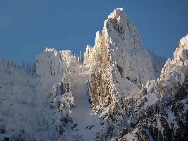
Castle Crags on December 18, 2021
When we visited last April, the forest surrounding the crags was frighteningly dry (below). What should have been a damp forest floor with streams swollen by meltwater was like a tinder box waiting for the spark that would ignite an inferno. Like the rest of the mountains surrounding the Central Valley, the snowpack was gone, literally 5% of a normal year. 

When we left on our trip on December 18, things were looking up a little. There had been a surprising strong storm in late October that had dropped some snow on the mountains, but warmer weather had melted much of it. A dry November left the snowpack at 19% of normal.

Then a bunch of storms coincided with our trip plans. When we stopped in at Castle Crags on December 18th, there was a delightful cover of snow on the peaks (the picture above). It seemed a promising beginning of a decent snowpack.

We were in Seattle area at the beginning of one of the biggest snow events in the city's history. We left the city on freeways so covered in ice that the lane dividers couldn't be seen, and everyone guessed (only somewhat correctly) where those lanes were. Spinouts and accidents were everywhere, and it took us nearly four hours to go the first hundred miles towards the south. We eventually outran the storm but stopped for the night in Oregon were the storm caught back up to us. 

Our next day was 380 miles of icy anxiety, but luckily the roads were clear when we reached the top of the Siskiyou Mountains and Mt. Shasta. But what huge amount of snow had fallen! Looking at the top photo in the post, you can see the high peaks were literally coated in snow.

Castle Crags on April 23, 2021
In a more official vein, the Sierra Nevada had jumped from 19% to 159% of normal snowpack in the space of three weeks (below). We've received the 52% of the total amount of snow year, with three normally wet months to go. And at least two more storms are forecast in the next ten days. It's really good news, a possible respite from the long-term drought that has been gripping the region. But it's a real mess if you have to be traveling in it.

Source: Snow Pack Conditions - Snow Water Content Chart (ca.gov)
But the snowpack is not the whole story. Reservoirs across the state reached critically low levels in two years of drought (below), and it will take more than a couple of good storms to build them up again. A heavy snowpack is great, but warm periods can prematurely melt and evaporate the ice. I'm going to stay optimistic, but my mind is telling me that this is a respite, not a solution to our problems. If we get a good water year, we will still face imminent droughts and depleted groundwater reservoirs. We need to face the problems, and not put them off. 

Source: Interactive map of water levels for major reservoirs in California | American Geosciences Institute
But it sure was nice to see all that snow!


Monday, May 17, 2021

Yosemite Valley This Week: A Moment of Spring Richness and an Uncertain Future


I admit it. I fear what lies ahead. That's not the usual opening statement in a photo-essay of Yosemite Valley at its best moments. But that's the problem. I was there last week, when the heaviest snowmelt should have been weeks in the future. And the valley was at its best, a lovely escape from the summer-like heat of the Great Valley downstream.
But the peak runoff is not weeks in the future. It is probably already past. This year's snowpack was an unmitigated disaster. The few storms that did come dropped a bit of snow, enough in some years to get by, but very warm and dry conditions during April dropped the snowpack to around 5-10% of normal, or what passes for normal in these uncertain times. The snowpack would usually keep the famous waterfalls busy until mid-June or even July, but many of them may be dry within a few short weeks. And then the fires will come. I don't know what lies ahead for this most beautiful of valleys, but a disastrous fire has to be considered as a possibility.
The natural condition of the floor of Yosemite Valley has always been controlled by wildfire. Lightning strikes have caused fires for thousands of years, leaving the valley floor as a patchwork of open meadows with a few mature oaks and ponderosa capable of surviving the occasional grass fires. When humans first discovered the valley thousands of years ago, they continued the practice of burning the valley floor every few years. They had their motives of course; the acorns of the fire-resistant Black Oaks provided much of their diet, and the hunting of game was easier when the prey was in an open meadow rather than a deep forest.
When the valley was "saved" by turning it first into a state park in 1864 and later into a national park in 1890, fire suppression became the governing philosophy. The park's original 745 acres of meadows were invaded by young saplings and the 65 acres of meadows today represents only 7% or so of their original extent. It didn't help that drainage outlet of one of the wetland areas was dynamited to keep down the mosquito population.
Much of the valley floor has become a thicket of young and unhealthy conifer trees, a fire hazard of the highest order. The park service has come around to accept the need for fires in the management of the valley, but their success has been spotty and controversial. Prescribed fires have been done in some areas of the park, but more than one has gotten out of control and damaged structures. And prescribed fires are done when soil and fuel conditions are on the wet side. That is not the case at Yosemite this year.

An alternate practice was begun around a decade ago, and it too has been controversial. Instead of burning, the park service has been allowing tree-cutting to be done in some areas to remove the unhealthy trees. The buzz of chainsaws does not seem compatible with the general notion of "preserving" natural lands, but it may be a necessary evil. It led to an unexpected change for me as we visited the park last week.

Everyone always seems to be in a hurry as they scurry through the park looking for parking spots. The traffic was a problem because the free park shuttles weren't running due to the pandemic. So to see the many features of the valley, one had to park and hike quite some distance, or else drive from parking lot to parking lot looking for a good view. I was letting traffic pass by pulling into roadsides that normally don't offer much in the ways of views. But this time was different.
A lot of trees had been cleared from a pullout that I knew had never had much of a view before. No one else was there, but as I got out I could see something was different. The rocks above were, well, unexpected. I've struggled at times to get an interesting angle on the Cathedral Spires (above), but they were easily visible. And as I turned, I realized the Three Brothers were also in the open (below). 
And as I turned yet again, I had a full-on view of El Capitan that showed the full expanse of the cliff from the "Nose" to Horsetail Falls. The sawn-down trees in the foreground were perhaps a sad mess (that will be cured in time by natural forces of decay), but the view of the cliffs was dramatic and quite unexpected. We sat in the pull-out and enjoyed a quiet lunch.
The Pacific Dogwoods were in full bloom. The trees are a somewhat nondescript part of the understory for much of the year, but during the spring the flowers are dramatic (and for the biologists among you, I know that the big white petals are actually modified leaves or bracts, and that the true flowers are in the "button" in the middle). 
Our journey through the valley was our first in nearly a year. It included a stop at one of the most congested spots, but as is always true, there was a reason for its popularity. The Tunnel View is close to the spot where European colonizers first viewed the valley in 1851. The party, a militia trying to chase down a group of Ahwahnechee people, was largely unimpressed with the valley. But their medic, Lafayette Bunnell, was deeply moved by the sight, and later interviewed Chief Tenaya and others to learn what he could of the valley. He is credited with the names of many of the features, including the name of the valley itself. Yosemite seems to have been a derivative of the Miwok name for Grizzly Bear. Their actual name for the valley was "Ah-wah-nee".
So a hot and dry summer season looms. I hope for the best.

Thursday, January 19, 2017

An Important Read for Californians, from The Center for Investigative Reporting


I'm kind of dropping everything and asking you to read the following article by Nathan Halverson from Reveal: Center for Investigative Reporting (and reposted in the High Country Times) entitled "All This Rain Won't Keep California From Sinking". It very accurately reviews the reasons the current storms are not going to solve California's water problems. The surface water may be okay for awhile, but the water underground is not being replenished, and that is going to have serious repercussions as move into the future. And almonds are a very big part of the problem.

Read the article. The picture I selected is a pasture that I've driven by on my commute to work for the last quarter century. In the last month, it disappeared, and in its place there are thousands, maybe tens of thousands of nut tree saplings. There is no new water to irrigate the orchards; it's being taken from underground aquifers, and in a few years, a decade or two at most, it will be dry and abandoned. And we'll all lose.

Monday, February 22, 2016

There's a Reason California is a Nice Place to Live, Drought and All

This post is directed (gently) at those who like to disparage those of us who choose to live in California, that dystopian socialistic state on the West Coast of North American continent. There are problems here like anywhere else, but there are moments of pure magic too. Those moments last days sometimes, even weeks or months. Take winter for instance. According to the calendar, it's still winter, and in many parts of the country people are still digging out of the snow. We have snow in California, at least when the drought is not so intense. We can visit our snow any time we want! And then we can go back down into our green valleys and soak up some sunshine.

We actually have two kinds of "snow". The other is falling off the almond trees about now, as the they bloom and set fruit. Yes, that's happening now. I left a week ago to go take a field class to Death Valley, and when I got back it seemed like the entire Great Valley was awash in white blossoms. It was a startling change.
Death Valley was having one of the greatest flower shows in decades, but coming home I realized that we are going to have a nice flower show in our valley and foothills this year as well. One of the best of our local wildflower spots is the Red Hills Area of Critical Environmental Concern (how is THAT for a name?). The little mini-wilderness in the Sierra Nevada Mother Lode protects a unique area of serpentine soils that have little in the way of invasive grasses, and lots of endemic flower species. It's on the verge of exploding into a living kaleidoscope of color. I'd be lying to say there were lots of flowers today, but there were a few dozen early blooms of Monkey-flower, but in a few weeks there will be thousands upon thousands. They'll be followed by orange Golden Poppies and blue Lupines shortly after. I'll keep you posted!

Wednesday, June 4, 2014

It's a Dam Big Reservoir, But There Are Some Dam Scary Things About It.

First off, I am so sorry for the dam puns. I'm a geologist, and we geologists are just no dam good at resisting stupid puns. It's something you'll just have to take for granite.

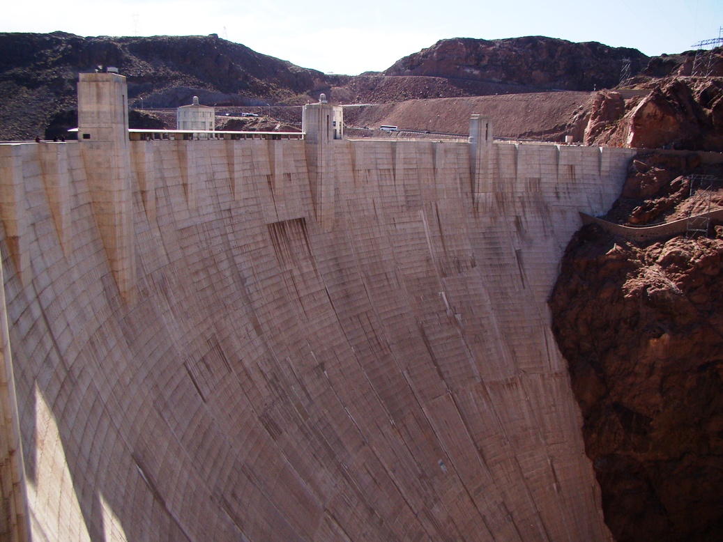
In any case, this is a dam big reservoir. It's Hoover Dam, the first of the gigantic mega-dams constructed in the U.S. back in the 1930s during the height of the Great Depression. Thousands of hungry unemployed men came from all over the country to work in the construction, and in the dangerous conditions, more than one hundred of them died. It's 726 feet high, which at the time was the highest dam in the world (it's the 18th highest now). It holds back about 30 million acre-feet of Colorado River water, equivalent to more than two years of normal stream-flow. At least, what was normal thirty years ago.
It's an astonishing achievement even if I seem to belittle it with semi-sarcastic puns. Walking across the dam is an experience in perspective. It is really big. Ultimately, some thirty million people in three states and Mexico depend on the water that it stores.
Not that it's pretentious or anything, but there are trimmings that make me think of the old USSR. Gigantic statures of winged gods greet the visitor on the Nevada side of the dam, and a loudspeaker emits a constant stream of platitudes about the glory of the achievement of making a river slow down for an instant of geologic time.
Can you guess the purpose of this golden door? Is it the entrance to the Watermaster's Throne Room, the portal into the Cathedral of Power Generation? No, it's actually the door to the men's bathroom on the top of the dam. Unfortunately it is undergoing renovation, so I can't show you the pretentiousness that awaits within (plus, I would have been arrested as some sort of creepy person).

Still, there are some dam frightening things about visiting Lake Mead and Hoover Dam. First and foremost, the dam is missing something. Water. It's missing a lot of water. It's sitting at the lowest level ever seen since the dam's floodgates closed in the 1930s. It hasn't been full as far as I know since the flooding in 1983, and prospects are not good for changing this situation in the face of ongoing drought and climate change.
Then you see stuff. Walking down the stairway from the new parking structure, there are all these square pieces of metal stuck to the cliff. What the hell? Those are rock bolts, essentially long screws encased in concrete and bolted to the rock wall for the purpose of maintaining the rock wall as an actual wall, instead of a rock fall. If the dam is built in stable rock, what do they need rock bolts for?
Then you start to notice other things. In the roadcuts across the highway from the dam there are strange looking scratch marks on the rock surface. They're called slickensides, and they develop as one block of rock grinds against another. Along a fault. Yeah, those things that cause/result from earthquakes.

Before I started researching the field seminar that I'm currently conducting, I assumed that Hoover Dam was anchored in ancient stable metamorphic and plutonic rocks. That is the kind of rock that is exposed in Black Canyon downstream from the dam. A close look at the rocks reveals a different composition: they are rhyolitic volcanic rocks, and according to the guides and the maps, they are Neogene in age, from around maybe 15 million years ago.
The volcanic rocks erupted in a complicated geologic environment of extension and transcurrent faulting that opened up spaces between crustal blocks that allowed magma to rise to the surface. They have been complexly faulted, and it turns out that a walking tour of the dam site is a nice lesson in a comparison of normal and strike-slip faulting. The dam engineers and the dam architects back in the 1930s declared the dam abutments to be safe and stable, and who am I to argue with them? I am not a dam engineer or a dam architect. It doesn't look like any leaks are occurring in the canyon walls downstream, unlike a certain other dam reservoir that I was looking at today.
The other dam thing I saw today wasn't really scary, except in my imagination. You have to realize I was looking down 200 feet at this big fish, a carp or something. It may have been three or four feet long, and for a moment it looked a dam shark! Maybe that Sharknado thing really happened, and a few landed in Lake Mead...

The dam morning was almost over, so we hit the road. We were headed towards the Grand Canyon, a much better place to appreciate the Colorado River.

Sunday, July 7, 2013

Out in America's Never Never: Desert Water...Gambling with 30 Million People

This water is flowing in one of the driest places in America (and naturally, too)

Water. Nothing in the world makes you appreciate it more than not having it.

In the desert, water is the factor that decides life. An organism adapts to the lack of it, or that organism disappears. The plants of America's Never Never either store it, have deep taproots, or they wither and die until the next flash flood. The animals either live near the few precious springs, or get their water from the plants that they eat.
Source: http://en.wikipedia.org/wiki/Colorado_River

The region between the Sierra Nevada and the western edge of the Colorado Plateau includes some of the driest landscapes in the world. Nearby Death Valley averages 1 or 2 inches of rain per year, and in some years receives none. The most it has ever received was 4.5 inches or so.

One single thread of water winds its way through this parched land. From the Wind River Range in Wyoming and the Colorado Rocky Mountains, the Colorado River gathers the snow melt from countless high mountain ridges and flows for 1,450 miles through one of the driest environments on the planet. In the five million years that it has existed in its present course, the river has excavated untold cubic miles of rock, filled in the huge delta at the head of the Gulf of California, and filled numerous hidden groundwater aquifers. Only in the last 100 or so years has the river been altered from this condition, due to the intervention of a unique new species on the planet. We have changed everything about the river and the balance of water use in the region. But for how long?

We spent a day traversing this dry landscape between the Mojave Desert and the edge of the Colorado Plateau near St. George, where we got a sense of just how dry this land is, and also how we have altered the balance of water use in the region. Our stops included the aptly named Valley of Fire State Park, and Lake Mead National Recreation Area.

The red sandstones of Valley of Fire are called the Aztec Sandstone, a Jurassic layer that is related to the Navajo Sandstone that makes up much of the scenery on the Colorado Plateau. Here in Valley of Fire, the rock has been jointed and fractured, and spheroidal weathering has turned the rocks into a wonderland of jumbled rounded boulders. The rocks were caught up in a compressional event in Cretaceous time called the Sevier Orogeny. Older Paleozoic rocks were pushed up and over the Aztec along a series of thrust faults. When the Colorado River established its present course, headward erosion along the tributary streams (in this case, the Virgin River) exposed the deeply buried rocks.

Water was available along the Virgin River, so Ancestral Puebloans and other cultures have lived here for thousands of years. They left a visible record of their existence in the form of petroglyphs in the desert varnish that covers many of the rocks. Their villages were small, in keeping with the limitations imposed on them by the lack of water.
Hoover Dam and Lake Mead

Contrast the existence of these small villages with the huge metropolis of Las Vegas. Or Phoenix. Or Los Angeles. For in the same way that the Virgin River made a small villages possible, the Colorado River allowed huge cities to exist in the desert. Phoenix survived for years with groundwater, but the water accumulated in the ice ages, and can never be replaced. A water table that began at a depth of 30 feet now lies hundreds of feet lower. The Central Arizona Project allows Phoenix to put a big straw in the Colorado River and draw out large amounts of water. Los Angeles got along with water they accessed (stole) from the eastern Sierra Nevada and Owens Valley, but they grew too much and needed more. Canals draw water into the Imperial Valley and further towards reservoirs that ring the L.A. Basin. Las Vegas is the most dependent; groundwater provides only 15% of their water. The rest comes from the river's big storage facility, Lake Mead. To their credit, they put some of it back. A permanent river with a constant flow of thousands of gallons per minute flows from their water treatment plants back into Lake Mead (remember, downstream users, you get what Las Vegas flushed away!). None of the river's water flows into the Gulf anymore.
Photo by Mrs. Geotripper

We stopped briefly at Callville Bay (in part to "add" some water back to Lake Mead), and were shocked to see the problem that faces these cities, and all the other stakeholders in Colorado River water. All the white, bleached area in the photo above is supposed to be under water. It hasn't been underwater in a long time, due to a horrific drought that has gripped the region for the last decade (and the drought continues). Lake Mead has dropped to historic lows, less that 50% of capacity.

Lake Mead is the largest reservoir in the United States, holding around 28 million acre feet of water, equal to two years of "normal" flow for the Colorado River. The reservoir is perilously close to "dead pool" level where it won't be able to generate hydroelectric power. What happens when the water runs out?
Photo by Mrs. Geotripper
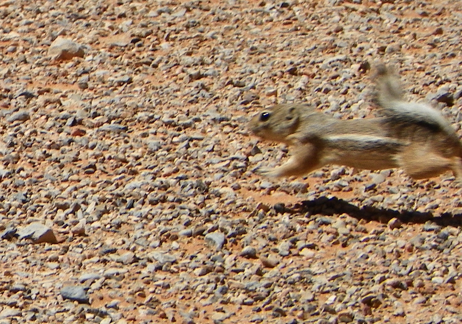
At Valley of Fire, we were amused by the antics of the small Antelope Ground Squirrels. When they got too hot, they buried themselves in the sand to cool off.

Unfortunately, we don't have the choice of burying our heads in the sand. We take for granted that we turn a knob and water comes out. It may not always be that way. The inhabitants of the American Southwest have some hard decisions coming as global warming continues to change our environment.

Oh, the dog in the opening photo? It's cooling off in Rogers Spring, one of the natural springs that flows out of a fault zone on the north side of Lake Mead near Valley of Fire. There is a bit of water to be found even in the driest places.
Monday, June 3, 2013

A Dam Big Dam and a Dam Big Bridge...And a Dam Frightening Problem

Oh, how mighty are the works of man...and how arrogant we sometimes get when contemplating our great works. Our first stop on our tour of the western Colorado Plateau was a visit  to Hoover Dam and Lake Mead, the gigantic tower of concrete that blocks the Colorado River, and holds back 30 million acre-feet of water. It's the biggest dam reservoir in the United States. How much is 30 million acre feet? More than two years of "average" Colorado River flows for one. The largest dam in our region back home, Don Pedro on the Tuolumne, holds a paltry 2 million acre-feet.

The dam was built during the height of the Great Depression between 1930 and 1935, and just two years after the catastrophic failure of St. Francis Dam in California that killed around 600 people. Lessons learned from the failure of St. Francis led to modifications of Hoover Dam which presumably make it more or less indestructable.

Just the same, it is amazing how many faults are exposed in the canyon walls adjacent to the dam. The rocks forming the abutments are Miocene volcanic tuff, which doesn't dissolve or crumble in water (a major factor in the St. Francis event). But the rock is highly faulted, and it is a great place to explain slickensides, the scratch marks that occur when blocks of rock slide past each other. The rock is literally polished.
The visitor center is guarded by giant copper art-deco angels that made me feel like I was entering the walls of Minas Tirith in Lord of the Rings.
The thing is dam big. It's more than 700 feet high, which was the highest in the world when it was built (now it is 18th). One can drive or walk across the dam thing, but it is no longer the main highway between Kingman and Las Vegas.
In 2010, work was completed on the O'Callaghan-Tillman Bridge just downstream. It towers 880 feet above the river, and more than 200 feet above the level of the dam. Walking across the top allows the incredible perspective of the dam and lake in the top photo of this post.
 Looking down the dam face is disorienting, but it looks like a great slide (although one's pants would surely catch fire from the friction...). The white thing is part of the power generating complex.
The bridge really is a stunning piece of work, although it is a bit disconcerting to feel it vibrate as the big trucks pass by...
Looking down the other face of the dam is disconcerting too. It's been a long time since the dam was full (1983 to be exact). The water level looks to be only a hundred or so feet low, but that represents perhaps half the storage capacity of the reservoir. A decade long drought has brought down the reservoir to perilous levels (13 million acre-feet), and some forecasts suggest it may never fill again. 30 million people in Los Angeles, Las Vegas, Phoenix and in many agricultural areas depend on the supply of water, but it just isn't there.

And that's dam frightening.


Monday, November 5, 2012

A Plea for Rationality: Science, Global Warming and the 2012 Campaign

Athabasca glacier (British Columbia) in 2005
Athabasca Glacier in 1909
Global warming is and will be one of the defining issues of our generation. It is so unfortunate that we have a political party that is in such a state of denial over climate change that it will fight to see that nothing is done for at least the next decade. As I have noted in the previous two posts, we have lost 12 years already when we could have made real changes in our production and consumption of energy. It isn't that the technology isn't there; we have simply chosen to ignore renewable energy technology in favor of continued production of oil, gas and coal.

Only one party accepts the need for change, but it has been hamstrung by the opposition. The Republicans are led by the likes of James Inhofe of Oklahoma, and Rick Perry of Texas, states that have been particularly hard hit by global warming in the form of horrific heat waves and crippling drought.

If it sounds like I am making a single-issue argument, I am not. Dealing with global warming is an issue that involves our energy policies, which in turn involves our foreign policy. We have now fought several wars in which the protection of oil and gas fields has been a primary aim. Does anyone remember that we liberated Kuwait in 1991 because we were worried about the civil rights of the Kuwaiti people?

Energy is going to be a burning issue in our economy as well (pun definitely intended). Anyone who doesn't like $4.00 per gallon gasoline is bound to be bitterly disappointed over the next 10-20 years as production falls while demand rises. Gas and heating oil will be increasingly expensive, despite the current excitement in the industry over fracking. Fracking just means we will produce and use up a limited resource all that faster. And the continuing use of fossil fuels will continue to fuel global warming, causing disruptions in agriculture and raising food prices as well.

Do we like our national parks? Global warming already has had measurable effects on many western national parks. Most notably, Glacier National Park will be glacier-free in a decade or so. In many the high mountain parks that I love so much, alpine species are being squeezed out, and pests are on the increase. I was appalled at the destruction of the Lodgepole forests across central Colorado on my trip there in 2011. The bark beetles responsible used to be killed by the intense winter cold, but no longer. And the fires...the devastation last summer affected all the western states, with record acreage being burned. It's only going to get worse.

We cannot hope to deal with as a society with global warming unless our citizens are educated. So this issue goes deep into the way we bring up our children as well. Science teachers at all levels are hamstrung by budget cuts that favor teaching to standardized tests, and they are not able to encourage rational and critical thinking.

I have been in turns angered and disappointed at how the campaigns have evolved over the course of the last year. I have not been responding rationally when I read some of the ridiculous things the candidates have been saying, including the few references to global warming and climate change. I felt like throwing things at my television, or flinging my laptop across the room. But I want to make some rational pleas to you now. I know I don't have the biggest soapbox around, and I may be mostly preaching to the choir, but I hope you will consider these arguments when you vote tomorrow.

If you live in California's new 10th congressional district, I hope you will consider voting for Jose Hernandez to represent us in the House of Representatives. Jose is a NASA astronaut and scientist; we have had few of either in congress over the years (John Glenn served well and there were a few others). He grew up in our valley, picking crops with his family. I would be far more assured to be represented by someone who has been trained in science. Representative Jeff Denham, his Republican opponent, seems like a nice enough guy, but he is a cookie-cutter Republican who voted with his party 95% of the time. He would do nothing about global warming and other science-related issues.

If you live in California, please vote in favor of Proposition 30 and against Proposition 32. The education system in our state has been ravaged by the Great Recession and the paralyzed legislature that cannot deal with taxes without a two-thirds majority. We have been given a choice to raise our sales tax one quarter of one percent to maintain our schools, colleges and universities. Not to raise our budgets, but to maintain what we have now. We can't cut anymore without damaging our society for years to come. Why vote no on Proposition 32? It would mean that corporations would have a clear field for unlimited expenditures in politics while hamstringing the unions and others who oppose them. Just look at who is supporting it.
And finally, I will be voting for President Barack Obama. I know there are many issues in the race and so many factors that go into a choice for president, some of them shallow and horribly misinformed, and some that are profoundly important. I know that President Obama is a proponent of science and intelligent choices in energy development (except for his pronouncements on "clean" coal). He has not been perfect, but he has proven to be a calm and collected leader in dealing with some of the toughest issues our nation has ever faced. I do not see any positive signs that his opponent understands any of the issues in energy, environment and education, and if he does, his many contradictory statements makes it hard to understand what he does know. I think Barack Obama has earned a second term.

Whether you agree with me or not, get the heck out there and vote if you haven't already done so. It is a precious right to do so in our society, and there are those who are trying to put up roadblocks. I am ashamed at the behavior of Governor Rick Scott in Florida and Secretary of State John Husted in Ohio and others in trying to suppress the vote in their states. To make someone stand in line for six or seven hours to exercise their right to vote is shameful and anti-American.