Showing posts with label Colorado River. Show all posts

Tuesday, May 25, 2021

What was the Greatest Adventure You Ever Had? Dreams, Hopes, and Memories in Pandemic Times


The first moment of the greatest adventure of my life
What's the greatest adventure you've ever had? And as you consider your future, what is the greatest adventure you ever hope to have?

I've been thinking about that this week, as we possibly, hopefully, approach the end of the pandemic that has caused so much tragedy and heartbreak. I'm teaching a "summer" class that actually ends four days before the official first day of summer, and in the new world of remote teaching, I've had my students submit an occasional online response to geology-related questions. Sometimes my questions deviate a bit from geology though, and this week I asked them what "adventure" means to them, and to recount the greatest adventure they've ever had. And realizing that some may not have had any identifiable adventures, I ask what adventure they would like to have someday.

Redwall Cavern, deep in the Grand Canyon. It is said that 5,000 people could fit in here.

I get lots of interesting answers, because a community college class roster is filled with people of many diverse ages and background. Sometimes they describe a hike in the local mountains, or a walk along the coast. Others describe some harrowing and dangerous life experiences related to the Peace Corps or military service. Because it is an online discussion, the give and take makes for fascinating reading.

Much of my motive in asking such questions is to help them realize that geology, in a way unlike many other disciplines, is an adventure in and of itself. The experience of finding a gemstone in the rough, uncovering a dinosaur bone, feeling an earthquake, encountering a flash flood, or witnessing a volcanic eruption are unforgettable adventures, even if there are negative consequences and dangers. That, after all, is part of what makes an experience into a true adventure.

Standing waves at Hermit Creek Rapids


Some people are content to live lives without 'adventure'. They are happy enough to find a career that satisfies, and prefer to spend their free time at home reading and gardening and the like. Who needs the stress and high blood pressure after all? I understand that perfectly well, but it sure didn't feel very good to have that life imposed on us by a global pandemic. It's the season when I would normally be preparing to take my students on some real adventures, across the southwestern states and the Colorado Plateau, or up north to the Cascades, Glacier and Yellowstone. Some years we explore Hawaii or Canada, or Australia. Instead, I am giving zoom presentations and grading online submissions, and dreaming of being outside.

I got a message from a friend that unleashed a flood of memories of the greatest adventure I ever had. It was innocuous enough: she asked if I had a recording of a community lecture I gave a few years ago about rafting the Colorado River through the Grand Canyon. I didn't actually remember if a recording existed, but I found it online and had a look. In a short moment I was transported back to the time eight years ago when my brother and his family invited me to join them on the 17-day adventure. I was 56 years old at the time, and was at one of those middle-age moments when one begins to wonder if the big adventures are coming to an end. It turned out that the answer was a firm 'no'. 

Scouting Lava Falls, the worst or second-worst rapid on the river depending on the flow. Yes, I capsized and rode it all in the water. Check my blog series below for the You-Tube of the moment.

I wrote an extensive blog series about the trip called "Into the Great Unknown" that will give you a sense of what it is like to explore one of the largest remaining wilderness lands left on our continent, and what it is like to face your own mortality and fears (there were indeed a few terrifying moments in an otherwise glorious time). But if you want a short and quick visual exploration, you can see my community lecture at this link: https://share.yosemite.edu/go=1EVB. I recall it was the most fun I've had giving a public lecture.

And just for the fun of it, here is the video of the final musical moments of our 17-day journey. We had to delay our landing at Diamond Creek because other rafters were getting on the river and space was limited.

So, as the pandemic begins to fade (if people don't get stupid when we are so close), what adventures will you seek? What are the places you want to see? What do you want to experience? What's on your bucket list, and what are doing to make it happen? And what was the greatest adventure you ever had? There is lots of room in the comments section to share your memories or dreams for the future.

Monday, March 2, 2020

Into the Great Unknown (Redux II): Journeying to my Roots, and to the Roots of Mountains

I was going over some of my old posts about my journey on the Colorado River in 2013 and came across this personal favorite, a post that discussed my own journey into geology back in 1976 during an earlier adventure of discovery in the Grand Canyon, on foot. It also included some of the most beautiful and dramatic rocks I have ever encountered. From August 30, 2013:
The photo above is my favorite self portrait from my journey down the Colorado River, into the Great Unknown. It's true that I appear in only a half dozen of my two thousand pictures from the trip, but this one captures best the sense of wonderment that I felt during the entire 227 mile long boating adventure. It was taken on one of the really special days of the trip, when we reached the ancients roots of a massive mountain range that today is long gone. It was also a day when I explored the roots of my own life adventure as a geologist and teacher.

And a day when I started to pay really close attention to the rapids on the river.

As a passenger on a raft (really, only a fool would allow me access to the oars in any rapid bigger than a riffle), we trust the boatmen. They are the ones who can quickly read and assess a rapid, either by standing up and observing just before entering, or by pulling ashore and scouting from above. They are the ones who make the snap decisions in the midst of chaos, deciding in an instant whether to pull left or right to get by the unexpected hole or pourover or eddy wall. They are the ones who keep their cool when the giant waves threaten to completely envelop the raft and sometimes tip it over (flipping is a highly undesirable outcome in a rapid; there's nothing fun about it at all). We trust them, and when they do their job really well, a passenger can actually become a bit complacent. If we've managed 40 or 50 rapids without problems, well, it can't really be that hard can it? And that's when things can get dicey.

Passengers play an important role in the run of a rapid, so we have to be paying attention as well. It's hard to imagine that pulling the oars makes any difference in the chaos of a rapid, but it does make a big one. Inches sometimes count. And when the raft threatens to flip over, the passengers have to be thinking fast enough to "highside", to fling themselves towards the rising side of the boat during a tip-over, using their weight to hopefully push the boat back towards the horizontal.

Why was I suddenly watching rapids with a renewed interest? We had reached the point on the river where John Wesley Powell was inspired to write one of his most famous passages, the one which also inspired the name of this blog series:

We are now ready to start on our way down the Great Unknown...We are three quarters of a mile in the depths of the earth...We have an unknown distance yet to run, an unknown river yet to explore. What falls there are, we know not; what rocks beset the channel, we know not; what walls rise over the river, we know not.

The next morning he adds:

At daybreak we walk down the bank of the river, on a little sandy beach, to take a view of a new feature in the canyon. Heretofore, hard rocks have given us bad river; soft rocks, smooth water; and a series of rocks harder than any we have experienced sets in. The river enters the granite!

We can see but a little way into the granite gorge, but it looks threatening.

He and the mountain men who served as his crew had already been on the the river system for two months, and with their inadequate clumsy boats had run or portaged many dozens of rapids that were terrifying. They were running very low on food (the diet: unleavened flour, dried apples and rancid bacon). And now the nature of the rocks exposed along the river promised rapids far worse than any they had encountered upstream.
Why were the rapids worse?

Indirectly, it was indeed the harder rocks. They were entering a part of the canyon composed of harder rocks than anywhere else along the river. It isn't the rocks themselves that make bad rapids, though. The river does not fall over ledges and waterfalls. Rapids on the Colorado River happen because of debris flows that enter the channel from the small tributary canyons. The debris in essence dams the river and forces the river channel to the side, making the cross-sectional area of the channel much smaller. Since the same amount of water in a river passes a given point in a given amount of time (cubic feet per second is one measure), the river must speed up to pass the barrier. You can see this effect in the picture above in Nevill's Rapid.

The severity of a rapid is determined by the volume and size of the boulders in the debris flows, and canyons cut into harder rocks produce larger boulders. Sprinkling a few giant boulders throughout a rapid turns a riffle into a terrifying roller coaster ride.
So that was the day we were facing. We would be entering the Granite Gorge of the Grand Canyon for the first time, and we would now need to run a gauntlet of the biggest rapids to be found on the entire river. It started with Hance (8 on a scale of 10), Sockdolager (7), and Grapevine (7). The next day would include Horn Creek (9). The day after that, Granite (8), Hermit (8), and the ultimate rapid, Crystal (10). These would be followed the same day by the seven rapids of the gemstones (Agate, Sapphire, Turquoise, Emerald, Ruby and Serpentine, ranging from 5 to 7). And 70 miles downstream (with plenty more rapids in-between) Lava Falls (10) awaited our arrival.
We came around a bend in the river, and I encountered a familiar sight in the midst of the Great Unknown. I had been here before! Not on a river rafting expedition, but on a backpacking trip in 1976. It had been one of the most important events in my young life, because it was the trip that set me on the road to becoming a geologist and teacher.

Geology of the Grand Canyon was actually one of the more difficult courses I had ever taken because not only did we need to master a lot of geology in a short time, but we also had to prepare for a challenging backpack down and then back up a series of officially unmaintained trails in the canyon (the New Hance and Grandview trails). The co-requisite for the class was a 2 unit physical education course in backcountry camping that including an entirely separate shakedown trip in the mountains of Southern California. When I came out of the Grand Canyon six days later I knew what I wanted to do with my life.

Of course, a few things have changed since 1976. Geotripper weighs, um, a lot more than that gawky teenager on the right in the picture below. Picture quality has improved, not so much because of better photographers, but it used to be expensive to take and develop pictures, so we never took very many. Plus we were using the old Kodak Instamatic cameras or something similar.

Still, seeing these pictures a few years ago on Facebook (thanks to J. Elson) brought a shock of memories, and now for the first time in forty years I was once again standing at the rapid that made a geologist out of me.
Only this time my mind was on other things. Back then when we finished, we turned around and started hiking back out of the canyon.
We were about to run a major Grand Canyon rapid in boats that suddenly seemed really small. Just like these river rafters in 1976. I noticed that the two biggest boulders haven't moved, and that the rapid was as chaotic looking as ever.

We had reached the base of the Grand Canyon Supergroup, and could now see the three formations that make up the oldest units: the Shinumo Quartzite, the bright red Hakatai Shale, and the basal Bass Limestone (intruded by basaltic dikes). The rocks are tilted about 15 degrees, giving the illusion that the river gradient is even steeper than it already seems. It can't have been a comforting sight to Powell and his men in 1869.

The Grand Canyon Supergroup sits on a mountain range of Andean proportions. Or more properly stated, the layers were deposited on the low erosional plain left behind when a mountain range of Andean proportions was completely washed away. The black schists and reddish granite intrusions once lay some five miles deep in the crust, and now they have been laid bare by the cutting of the Grand Canyon.

The rocks today are called the Granite Gorge Metamorphic Suite, and they formed in a series of collisions between a group of volcanic islands (called terranes), and the ancient North American continent around 1.7 billion years ago. The metamorphic schist and gness units were intruded by granitic magmas at intervals between 1.7 and 1.4 billion years ago. And now those rocks are exposed in the very deepest part of the Grand Canyon.
We successfully negotiated Hance Rapid (not without getting positively soaked), and looking back upstream, I could see the basalt dike that I had found so utterly fascinating on my first trip into the canyon.
The canyon was dark, but I did not feel as sense of brooding. I was exhilarated, my imagination seeing the peaks and canyons that must have existed here in the distant past, mountain slopes which would have been utterly lifeless and barren. Deep gorges must have been cut by rushing rivers that were never seen by any living thing. Entire Grand Canyons could have been carved here and we will never know of their existence. We now entered a fascinating world of exceedingly rugged vertical canyon walls. The silt and sand polished the hard granite and metamorphic rock.

Sockdolager Rapid (the word is an archaic term for knockout blow in boxing) was a fun ride, nothing like the terror-filled lining and portage in Powell's writings.

It was hard to find a spot to scout, so the boatmen checked out the rapid by standing up as they approached.
Between rapids the river was calm, and the canyon walls rose straight from the water.
The metamorphic suite was composed of the most diverse and beautiful rocks that I had seen anywhere on the trip. The polishing simply added to the beautiful sculpted appearance of the rock.
We arrived at camp in Cremation Canyon by 2:30. We had pulled in early because we would be saying goodbye to three of our fellow travelers who would be hiking out of the canyon from Phantom Ranch, and meeting three others who would take their place for the remainder of our journey.

I turned in early once again...tomorrow we faced the biggest rapids so far on the trip.

Saturday, February 29, 2020

Into the Great Unknownn (Redux): A Journey Down the Colorado River Through the Grand Canyon

As some of you remember, I took a rafting trip down the Colorado River through the Grand Canyon in 2013 with my brother's family. I later did an extended blog series on the journey, and I've compiled the posts in their original order, so you can follow whole story in one place.


I've been reliving the journey in my mind these last couple of weeks because I just finished an outstanding book called "The Emerald Mile" by Kevin Fedarko. It describes an epic river journey during the singular flood event on the Colorado River that nearly destroyed Glen Canyon Dam. Instead of just being about the race down the river, it is a fascinating history of the exploration of the Colorado and the "taming" of the river by the giant (yet vulnerable) dams that were placed in its path. And it is a nail-biter of a narrative about the efforts of engineers to contain a failing dam in the face of an unprecedented flood (there are echoes of the more recent near-disaster at Oroville Dam here in California a few years ago).
The story resonated with me for so many reasons, not the least of which is that I was imperiled by the insane raging waters of Crystal Rapid, though not at the crazy flows of 1983. I found myself reliving so many aspects of my journey down the river.

The Colorado River through the Grand Canyon is both a tourist "bucket list" thing that has become very popular (and therefore potentially dangerous for those who underestimate the river), but it also is a journey of the spirit and body through one of the great wilderness areas left on Earth.

Here are the posts...

Rafting the Colorado River: This is the original post in the series, explaining how I got there, and what I was feeling about a journey that I waited forty years to complete.

Everything you wanted to know about rafting on the Grand Canyon but were afraid to ask: A description of what's involved in a 16 day journey on a river with no stores, bathrooms or trashcans.

Cloudburst (x2)! And Off We Go: Two intense thunderstorms give us a muddy sendoff down the river. Page and other towns got pounded that week by flooding.

Passing through the Permian Period: Our first day on the river takes us through the upper layers of the Grand Canyon, the Permian-aged Kaibab, Toroweap, Coconino and Hermit formations.


Whodunnit? A Mountain Range Goes Missing: The Hermit Formation and Supai Group provide evidence of the existence of a long-eroded mountain in southwest Colorado. And I row a raft for the first time!

Visions of Paradise and a Bug's Horror: We enter Marble Canyon, dominated by the beautiful cliffs and caverns of the Redwall Limestone. A beetle has a tough day.

Exploring 300 million year old and 50 year old caves (and some fossil hunting): We explore Nautiloid Canyon and an exhumed Paleozoic cavern. We also see evidence of a bone-headed plan to dam Marble Canyon. It would have been an unspeakable crime...

Looking for the Rivers within the Rivers of Marble Canyon: The Devonian Period is represented only by the Temple Butte Formation and the exposures are discontinuous because they were originally only the fill within eroded stream valleys. Plus a cool side trip to a small waterfall.

We interrupt this scenery for a very recent flash flood and a biological disaster: The cloudbursts we experienced a few days earlier caused some flooding in the side canyons. And a look at the tamarisk tree, an invasive species.

Catching an Iconic Scene in the Grand Canyon, and a Bi-Colored River: The small Ancestral Puebloan granaries above Nankoweap Canyon are one of the more famous sights on the river, but oh, what a climb! And floodwaters in the Little Colorado change the color of the main river.

Living in a Thomas Moran Painting, and Through a Canyon Storm: A passing storm gives the canyon a dreamy impressionistic look. I get my favorite picture, and I don't get overly wet; there were too many gigantic boulders to cower under.

In the depths of the Grand Canyon there are three more Grand Canyons...Checking out the Supergroup: There is around 12,000 feet of ancient sediments and volcanic intrusions tucked in the deepest parts of the canyon, and they are only accessible by river or long hot hikes. We give them a look.

Journeying to my Roots, and to the Roots of Mountains: We reach some of the monster rapids, including Hance. It was here in 1976 that I was becoming a geology major on my very first field studies class. Who is that gawky thin kid?

Exploring the Heart of a Long-Gone Mountain Range (and words from home): In the bottom of the Grand Canyon there are the roots of a huge mountain range that formed before complex life even existed on our planet. And I hear words from home for the first time in week.

We Run the Big Rapids, Sometimes in Rafts: We run three of the biggest rapids on the Colorado River. I experience something I haven't felt in a long time: terror. We flipped on the biggest rapid and I took a long cold swim through the 10-foot waves and the Rock Garden.

The Aftermath of Chaos...Finding Beauty in the Oldest Rocks of Grand Canyon: The Granite Gorge was a terror-filled place for John Wesley Powell and his men in 1869, but for me on a day after the rapids disaster it was a beautiful place.

The Hidden Places and Putting a Hand Across 1.2 Billion Years: Every side canyon in the Grand Canyon holds a treasure. We visited two, the Elve's Chasm and Blacktail Canyon, and we laid our hands across 1.2 billion years at the Great Unconformity. We also met with a herd of bighorn sheep.

Crossing the Great Unconformity Again...But Which One? There are really two major unconformities in the depths of the canyon (and more than a dozen more minor ones). We got a glimpse of the angular unconformity, and explored the billion year old sills, intrusions of basaltic rock that lined the canyon for a few miles.

A Gigantic Failure Produces One of the Most Beautiful Sights in the Grand Canyon: Slope failure and landslides had as much to do with the formation of the Grand Canyon as the Colorado River. At Deer Creek, a landslide produced one of the most beautiful canyons and waterfalls in the entire canyon.

Mad Cats and Amoebas? Trying to Keep Names Straight in the Grand Canyon: Not many people saw this post for some reason, but Matkatamiba Canyon is one of the prettier side canyons on the river, and one of the favorites of the veterans of previous river trips.

"Disaster" in National Canyon, and the Volcanoes of Grand Canyon: An unbelievable flood last year, and an unbelievable amount of basalt lava in Grand Canyon. And just like that we are facing Lava Falls, the single worst rapid on the river, in turbulence if not length.

Zero Hour at Lava Falls: A story of courage, redemption and the triumph of the human spirit? No. I tried to ride Lava Falls in a raft, but had to swim instead. Involuntarily. See the video version!

Vulcan the fire god says "You call that little piece of concrete a dam?: Lava dams in the Grand Canyon may have stood 2,000 feet high, and may have backed up dams for three hundred miles or more upstream.

Heat...and All Things Beautiful: It was post-Lava Falls, and one of the hottest days we had on the river. And the beauty surrounded us, in the water, in the cliffs, and in the animals.

The Last Day...An Elegy for a Journey, and for a River: I didn't want to leave. The last two miles on the river were the most precious of all, drifting slowly in the current. And then it was over. We derigged and made our ways to our homes, and the Colorado just rolled on.

Saturday, July 7, 2018

Home From Back of Beyond: Images of a Harsh Country, Part Three

This first photo may recall the disasters unfolding in the American West and Hawai'i with out-of-control wildfires and volcanic eruptions, but in this case it is no disaster. It is was the sunset on the tenth day of our recent exploration of the Colorado Plateau. We had finished our explorations of Arches and Canyonlands National Park and were headed west, towards home. It's funny, the emotions that can arise on a long journey. It felt like we were nearing the end of the trip yet we still had five days and four nights to go, and there were still four national parks on the itinerary. I've put together two previous posts of my favorite shots from the trip, and this is the third and final chapter.
We had been out for a long time, so we gave the students half a day of free time in Moab, Utah to do laundry, shower, and peruse the rock shops. But first we had one other major archaeological stop to make. The sandstone walls of the Colorado River gorge downstream of Moab contain some fascinating petroglyphs. They are cleverly hidden behind a big highway sign that says "Indian Writings".
Having signs pointing to fragile petroglyphs along a busy highway might not seem to be a good preservation strategy, but in this the highway construction itself provided the protection. There was very little space along the river for road construction, so the crews removed many tons of fallen debris to make room, the same debris the original artists stood on to chip out their art. Many of the petroglyphs are now inaccessible, fifteen or twenty feet above the roadway. One of the most unique is the bear, surrounded by hunters with bows and arrows (I think the artist was bragging).
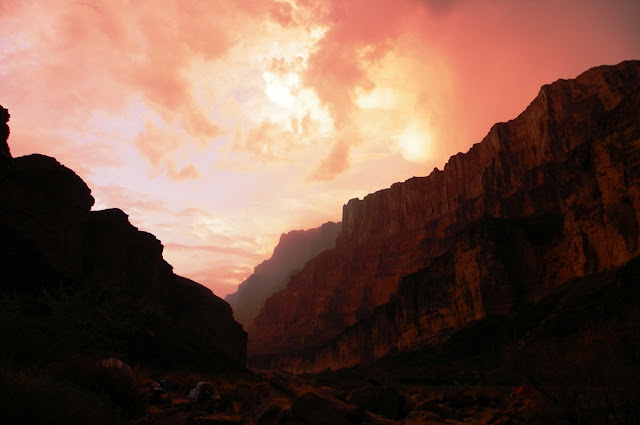
In the afternoon we headed west and south across the barren lands around Green River. The small village is the final settlement for a hundred miles west along Interstate 70. The only settlement to the south is Hanksville, around fifty miles away. We were in one of the most isolated regions of the lower 48 states. Our destination for the night was Goblin Valley State Park on the San Rafael Swell. The sunset was glorious (the first picture of today's post was also taken there).
In Jurassic time an ocean embayment extended south from Canada into the Colorado Plateau region. Called the Sundance Sea, it left behind all manner of tidal flats, delta deposits, and coastal dunes. The Entrada Sandstone displays many of these environments, and erosion has carved the rock into a variety of fascinating shapes. For one, most of the arches of Arches National Park occur in the Entrada. At Goblin Valley, the rocks were more thinly-bedded and produced small mushroom-shaped spires that gave the valley its name. If you are a fan of sci-fi flicks, you may recognize Goblin Valley as the setting for some scenes from Galaxy Quest (the one with the little purple aliens and the rock monster).
Looking south from Goblin Valley we could see the high peaks of the Henry Mountains, often described as the last mountain range in the United States to be discovered and explored (in the 1870s). Like the La Sal Mountains described in the last post, they are laccoliths, mushroom-shaped intrusions of magma. It was at the Henry Mountains that the term laccolith was first proposed by Grove Karl Gilbert, a pioneering American geologist.
Stars. Night after night of the most starlit skies I can remember. We were in the darkest corner of the continent, and our nights for the entire trip had been free of moonlight, but the following day the thinnest crescent moon I could remember ever seeing was setting in the west. I noticed later that this first appearance of the moon on June 14 was the ending of the month of Ramadan.
Our destination the following morning was Bryce Canyon National Park. The Colorado Plateau is a remarkable region because for close to a billion years it had been remarkably stable, remaining at or close to sea level throughout Paleozoic and Mesozoic time. But in the Cenozoic this began to change as the land rose above sea level for the last time. During the early Cenozoic Era (60-40 million years ago) the region around Bryce Canyon was a huge freshwater lake. The resulting pink siltstone an limestone layer is called the Claron Formation.
The rocks of the Claron Formation are cut by vertical fractures called joints, and these fractures allow water and ice to widen the cracks and forming the spires of Bryce Canyon. The rock towers are called hoodoos. Sometimes arches and natural bridges will form during this process (natural bridges cover a watercourse while arches do not). Does anyone want to guess what kind of opening this is in the picture below? (Hint: It's named Natural Bridge)
Bryce Canyon is an exceedingly popular national park. Besides the spectacular scenery, it lies in close proximity to Zion and Grand Canyon National Parks and thus makes a "grand triangle" of a tour so beloved by bus companies and tourists on a time budget. The popularity combined with the rush that most people are in to get to the most possible localities means that certain parts of the park are more impacted than others. The free trams go to the most crowded parking lots, and the entire south end of the park tends to be far less crowded and hectic (at least in my experience). If you ever visit, make every effort to go beyond Inspiration Point and see Rainbow Point and the many other pullouts. It will take you no longer to see them than it will to wait for a parking spot to open up at the more popular viewpoints.

By the time we left Bryce that afternoon we were making serious mileage towards home. We crossed the deserts of western Utah and arrived at one of my favorite national parks of all: Great Basin. The park is not a basin, it's a mountain range, the Snake Range. It was established in 1986, although a small portion, Lehman Caves, was made a national monument in 1922. The political journey leading to the establishment of the park was different than most. As I came to understand it (and please, provide some insight in the comments if I have this wrong), there was a desire to have a national park representing the best of the Basin and Range geologic province, but promoters were split between three possible locales! There was the Toiyabe Range in central Nevada, the Ruby Range/East Humboldt Range in the northwest part of the state, and the Snake Range, which got the eventual nod. Purists supported the Toiyabe Range because it best exemplified the unique ecosystems of the Great Basin whereas the other two showed more affinities for Rocky Mountain flora. It was an interesting problem because the Ruby Mountains and Snake Range offered more "normal" mountain scenery along with glacial lakes. They really are a bit more like the Rockies. I suspect that the Snake Range got the nod because it already had the infrastructure for a national park (an extant visitor center, for instance), it had Lehman Cave as a centerpiece, but it also had Nevada's only glacier, and a forest of Bristlecone Pines, the oldest living organisms on the planet.

The park also protects Wheeler Peak (13,063 feet), which is the highest peak entirely within the boundaries of the state of Nevada (the actual high point, Boundary Peak, is a spur on the ridge of a higher peak in California, and it is only about 50 feet higher than Wheeler). There is a spectacular ridge-hugging paved road that reaches the main trailheads at over 10,000 feet.
Great Basin is one of my favorites because it still retains the character of what most national parks once were: havens of serenity and wilderness. The park is generally uncrowded (except for the lines at the visitor center for cavern tour tickets), and mostly undeveloped. There are roads and campgrounds, for instance, but many of the roads are unpaved, and the campgrounds are old style: vault toilets, and no hook-ups. The last time I checked, the campfire programs were actually done around campfires, without screens and PowerPoint presentations. I hesitate to even tell you about this because you might want to go and see it, and it will get crowded like all the rest. Just kidding, go see it. It's beautiful, and the caverns are wonderful too.
The next day was a long drive across Nevada, and we had one more night, staying at Berlin-Ichthyosaur State Park. It's a fascinating place and I would describe it in detail, but I took few pictures, and this post is all about my favorite shots from the trip (you can read some details in this post from a previous trip). The next morning we were homebound and quickly crossed the western desert hills of Nevada. We crossed Anchorite Pass and rolled into our home state of California  In a matter of minutes Mono Lake came into view. We took a break at the Interagency Visitor Center at Lee Vining.
Mono Lake is a singular ecosystem in California, like no other place in the state. It occupies a large tectonic basin, meaning it has no (current) natural outlet. Lots of water flows into the lake via streams from the adjacent Sierra Nevada, but the only way water can leave is by way of evaporation. Because of this, the salt content of the lake is three times that of seawater. Few organisms can survive such conditions, so the ecosystem is pretty straightforward: some algae, trillions of brine shrimp, trillions of brine flies, and millions of migratory and resident bird species. Mono Lake is one of the most important stops on the Pacific migratory flyway.

Unfortunately humans always find a way to muck things up, and Los Angeles worked really hard to mess up this system. It involved building a 200 mile-long aqueduct and an eleven mile-long tunnel under a series of volcanoes to siphon off water from the tributaries that drain into Mono Lake. When the city closed off the streams in 1941 Mono Lake began drying up and lost 45 feet of elevation. The salinity drastically increased, threatening to kill off the shrimp. Lawsuits dragged on for years, but now an agreement is in place to raise the lake to a sustainable level. If only the California drought would cooperate...

The day we arrived the lake was (for me) an unusual shade of turquoise. The clouds were a sight as well. There had been not a great many clouds during our trip. The lack of rain was nice, but the entire route of our trip has been in the grip of an exceptionally severe drought. We wouldn't have minded a drencher if it could have helped.

Our final national park of the trip was in some ways the most familiar, but we didn't see it from a normal angle. Something like 90% of the people who visit Yosemite National Park go to the iconic valley, but the valley makes up only 7 square miles of a 1,000 square mile park. We entered the park at Tioga Pass (9,945 feet) and drove through the alpine meadows of the upper Tuolumne River. After more than 3,000 miles of barren desert environments, the greenery was stunning. We made a final lecture stop at Olmsted Point, which provided a unique view of Half Dome, from upstream.

But that was it. Once everyone realized that we had crossed the headwaters of the river that flows through our community, there was no slowing down. Homesickness is a powerful emotion and it was almost as if our vans took on a life of their own as we rolled down the western slope of the Sierra Nevada to the end of our journey. Like crazed tourists, we had visited 10 national parks, 9 national monuments and recreation areas, and maybe a dozen state parks. We had traversed a geological history encompassing 1.7 billion years of geological events and thousands of years of human history. All it took was 15 days, 3,700 miles, and a great group of students and volunteers!

Come join us some time in the future. We're headed to the Cascades this fall with a five day trip to Mt. Shasta, Lava Beds National Monument, Lassen Volcanic National Park, and McArthur-Burney Falls State Park. Contact me for details...