Yesterday we looked at five of the most incredible places I've ever stood. The post had become very long, so I decided to cut it in half. What follows are the final five of the most incredible spots. We've been working our way through my favorite posts in ten years of blogging...
Number 5: Walking in the Footsteps of James Hutton, Scotland (From May 6, 2014)
This entry into my series on the "
Ten Most Incredible Places I've Ever Stood" is sort of a two-for-one deal. It was my journey into a different kind of geological past, the history of the science rather than the history of the world, although that was part of the story too. This was a visit to the birthplace of geology as a science, at two locations in Scotland.

"What clearer evidence could we have had of the different formation of these rocks, and of the long interval which separated their formation, had we actually seen them emerging from the bosom the deep? We felt ourselves necessarily carried back to the time when the schistus on which we stood was yet at the bottom of the sea, and when the sandstone before us was only beginning to be deposited in the shape of sand or mud, from the waters of a superincumbent ocean. An epocha still more remote presented itself, when even the most ancient of these rocks instead of standing upright in vertical beds, lay in horizontal planes at the bottom of the sea, and was not yet disturbed by that immeasurable force which has burst asunder the solid pavement of the globe. Revolutions still more remote appeared in the distance of this extraordinary perspective. The mind seemed to grow giddy by looking so far into the abyss of time...."
These are the words written by John Playfair as he described an extraordinary boat journey he made with James Hutton in 1788 to Siccar Point, a spot where Hutton found confirmation of his model of the Earth's development. At the point, Silurian graywacke sandstone layers (425 million years old) stand nearly vertical, and are overlain by bright orange and brown layers of the Devonian Old Red Sandstone (345 million years). Such features are called unconformities. During the interval of time before the deposition of the Old Red Sandstone, the sea floor had been compressed and thrust upwards into a mountain range that was subsequently eroded completely away. Such events required the passage of vast amounts of time, something quite incompatible with the mere 6,000 years of Earth's existence assumed by medieval religious scholars. Hutton's explorations of Scotland ignited the revolution that led to the development of the science of geology.
In 2001 I had the chance to visit some of Hutton's most famous rock exposures. We had put together our very first international field studies journey to England and Scotland, and being unfamiliar with the territory, we had contracted with a tour company to take care of the logistics. We got a canned tour of the famous tourist localities like Stonehenge, Big Ben, and Edinburgh Castle, but we made special arrangements with the tour company (for a price) to deviate from their usual itinerary (we missed the golf courses of St. Andrews) so we could instead head into the southern uplands of Scotland to Siccar Point. We committed to the trip 1 1/2 years in advance, having no idea that hoof-and-mouth disease was about to be detected in the British Isles, including the farms around Siccar Point. To my almost unspeakable frustration, access was impossible. Not wanting to just give up, I pulled out the topo maps and we made our way to a campground on the coast about a mile north of Siccar Point. I read the passage from John Playfair to the students, and than I
ran as far as I could along the beach cliffs to where I could see the point, but not the relationships (although we could pick up the associated rocks along the coast).
The idea of unconformities and the concept of geological time would have been enough to secure Hutton's reputation as a geological pioneer, but he made another profound observation in the middle of the city of Edinburgh. That was the second spot I was seeking on this geological pilgrimage.
For years I've been showing a video to my students on the development of the theory of plate tectonics. It was done in the early 1990s but has held up well aside from the ancient computers in some of the scenes. It begins in Edinburgh with a look at the Salisbury Crags and Arthur's Seat, where James Hutton discovered an ancient volcano that once sat on the sea floor. Other observers in these early days of geology thought that basalt accumulated on the sea floor by precipitating out of the water, much like salt deposits in a drying bay. Hutton found a contact zone in a small quarry at the base of the Salisbury Crags where the intruding basaltic rock had pried up the previously existing sedimentary layers forming a vast
sill. In other parts of Scotland he found intrusions of granitic rock that had done the same thing. In short, he had discovered intrusive (or plutonic) igneous rocks, and opened our eyes to an entirely different way of considering our planet, an active planet with an internal heat source, and cyclical processes that had been operating for millions, not thousands, of years.
I didn't have much of a clue about how to find the quarry, but sunset came late in our northern latitude, so after dinner I set out from our hotel and walked to the crags. It didn't actually take very long before I found a concrete monument and the very exposure that had been illustrated in Hutton's early books. It was a marvelous moment in my geological life (and a great sense of relief because I was going to be showing it to my students the next morning and had to pretend I knew where it was all along).
The big adventure of the next day would be the climb up to the summit of Arthur's Seat, the eroded and glacially scoured volcano that had once been in an ocean. The peak is surrounded by the city of Edinburgh, and was originally preserved as a deer hunting park for the king, but more recently because of a number of rare plant and animal species, as well as being a bit of greenery in an urban setting.
The peak is an archaeological treasure with the remains of ancient fort at the summit, and the ruins of a chapel, St. Anthony's, built in 1425 on the flanks. It was such a strange sight for the middle of a city.
Although it was a bit hazy, the whole city was visible from our 822 foot summit. We could sit on our "throne" and consider the volcanic eruptions that built up the volcano, the continental collision that deformed and tilted the rocks, and the glaciers that scoured the flanks during the ice ages of the last two million years.

Do these pictures look a little fuzzy, a bit low of resolution? There's a story there. I had heard of digital cameras, but they were expensive and I couldn't fit them in my budget (my, how times have changed...). Because the Scotland trip was a major event for our department, I convinced the administration to spring for a modest camera (an entire 3 megapixels!), and it arrived in Shipping and Receiving late in the afternoon before our departure the next morning. When I got on the plane, I had taken and downloaded all of three images. I barely knew how to use the camera, and didn't really trust the technology, so I ended up mostly taking lower resolution pictures. I would never make that mistake again, but such is the learning curve. At least I didn't accidentally delete them all like I've done on a few other occasions. If you would like to see some very excellent and more recent pictures of Arthur's Seat, check out this recent post at Magma Cum Laude:
http://blogs.agu.org/magmacumlaude/2014/04/06/edinburgh-arthurs-seat-and-salisbury-crags/
Not many people in Edinburgh know of James Hutton, and his role in the development of the science of geology. Mostly I got blank stares when I asked directions to the monument. James Hutton is buried in Edinburgh and we paid a visit to the cemetery, but they had to pull out a catalog to find out where he lies buried. The section of the cemetery where he is interred was locked and chained, apparently because of continuing abuse by leaders of the popular ghost walks of Edinburgh (yeah, I took one too, but aside from atmospheric fog in the streets I was unimpressed).
 |
| Hutton's resting place is on the left side of this yard. |
How much does the average person know about Scotland and England? That there is a queen, and the men wear kilts. We of course realized that we weren't going to be seeing any queens, and it was silly to think that all the men in Edinburgh would be going around in kilts. Except that both of those things happened!
As we made our way down the road towards Arthur's Seat, we noticed that nearly every man on the street was wearing a formal kilt, and we wondered why. As we approached Holyrood Palace, we realized that everyone was gathering for a "garden party" hosted by Queen Elizabeth. There were just a few people in attendance, about 8,000 of them. From our vantage point on the flank of Arthur's Seat, we could pick her out, wearing a blue outfit in a receiving line next to the side of the building just slightly left of center in the picture below. Yes, it was a crazy, unique day.
Just to accent the weirdness, we passed the street sign below. It wasn't actually a prophecy, but instead was an alleyway (a 'close') on the edge of the old city, which was the edge of the world to the medieval inhabitants.
Number 4: What it's like to be the first person to see a cavern? Kartchner Caverns, near Benson Arizona (from May 8, 2104)
Can you imagine flashing a light in a dark corner of a cavern, knowing that you are the first human being ever to lay eyes on the formations? I haven't had that privilege in my life, but I have found two or three places where I can imagine what the experience was like. Most of the caverns that are accessible to amateur spelunkers like myself have been long known and rather completely explored. Unfortunately, most of them have been severely vandalized, and the early use of torches for light left soot deposits on the formations. It is a rare treasure to see a cave where damage has not yet happened. Such caves in my experience include
California Caverns near San Andreas, California,
Black Chasm Cavern near Jackson, California, and the subject of today's post, Kartchner Caverns near Benson, Arizona.
 |
| Many of the speleothems are still active; there are water droplets on many of the soda straws |
The "
Ten Most Incredible Places I've Ever Stood" series has been a series of hard choices. This one made the list because of the shock and the awe, the way the cavern made my jaw drop as I stepped in. It is an experience unlike any other that I've had while underground. There is a difference between even a well-protected cave, and one in which whole areas have never been touched by a human being. The floor of one of the large rooms was covered with mud, and it was clear from the trackway above that only one trail through it was ever made, in order to put in a light source. The rest of the room remains as it was discovered.
 |
| How incredible is it that some of the soda straws that fell are still standing in the mud? |
The discovery and visitation of any cave causes irreversible changes. Kartchner Caverns were discovered on private lands in 1974 and the people who found them were concerned about preserving the original cave environment. The cave was at nearly 100% humidity, and opening it to the desert environment would have dried it out. Such changes in humidity can adversely affect life in the cave and stunt the growth and development of
speleothems (cave decorations like stalactites and stalagmites). And yet the caves were spectacular. Was there some way of preserving the caves while making them accessible to the public?
The discoverers hit on an audacious solution. Through a series of delicate and secret negotiations, the owners of the land agreed to sell the lands containing the cave to the state of Arizona to be developed as a show cave, but to be developed in such a way as to preserve both the features and the climate inside the cave (many of the legislators didn't know what or where the park was when they voted for it). They preserved the humidity of the cave using a series of unique airlocks. Pathways were constructed with a minimum of disruptions to the original configuration of the cave. It took 25 years from the time of discovery to the opening of the park to the public in 1999.

There was one catch. Nothing goes into the cave with the visitors. No food, no water, no backpacks...and no cameras. As you might expect, I live for photography and this for me was a hard restriction. In 2005, though, I got the opportunity of a lifetime: as part of a fund-raiser for the park's foundation, they had a photography day, and the National Association of Geoscience Teachers made arrangements for us to take part. I was going to be given access to the cavern to photograph to my heart's content. To be sure, I had to sign a waiver of commercial rights, and the images that you see in this post today are protected and cannot be sold or used in any way.
 |
| Perhaps the most incredible stalagmite/column I've ever seen |
What a wonder it was to step into a cave that appeared the same as it was on the day of discovery! The airlock closed behind me and although the temperature was only 78 degrees, it felt much hotter because of the intense humidity. The passageways were dimly lit and it took some time to develop my night vision. But moment by moment the cavern came into focus. It was simply stunning.

I wandered from passage to passage lost in the moment. It was nice not having a guide (staff were stationed throughout the cave to answer questions and keep an eye on things), but it was also nice to be exploring a pristine cave knowing I wasn't doing major damage just by being there. Exploring a newly discovered cave means leaving muddy footprints and accidentally destroying delicate formations underfoot, or leaving trails in the mud. I remember thinking that the experience was something like being in a museum, but I thought that in a good way: the resource was being protected, and yet hundreds of thousands of people could see and enjoy it.
 |
| Some marvelous "helictites", otherwise known as stalactites on LSD. |
Although I can't be mistaken for a professional photographer, I learned long ago that photography in a cave is always tricky. There is no "natural" look to a cave except total darkness, but a camera flash steals perspective and washes out delicate differences in color and shading. I used the ambient lighting to maintain some depth to the photos. That meant standing very still for longer than usual exposure times (tripods weren't allowed at the time).
Flowstone refers to speleothems that result from water seeping out of cracks in the walls of a cavern. Over time gigantic mounds build up that resemble ice cream sundaes. Kartchner is full of spectacular examples.
I'm not sure what to make of the features below. There are some nice soda straws, which are so delicate that they are the first to be broken off in unprotected caves. The spiky things are the beginnings of helictites, which tend to ignore gravity, growing instead under the influence of water pressure from the interior of the "confused" stalagmites.

Below, one can see a spectacular column in the foreground, and some marvelous draperies in the upper left background. None of the features were broken off, and none were vandalized. I can barely describe what it is like being in such a place. Every minute in the cave was precious. I know there is an argument about worrying over technology in situations like this, and that one needs to live in the moment, reveling in the experience of being, but I actually find caves disorienting. Despite all my orienteering skills on the Earth's surface (and people tell me they are formidable) I get lost in caves. I can't remember one room or one decoration from another. Photographs keep me centered, and keep the memories of the moment alive. And I can share them!

I passed a stunning wall of draperies. Time was beginning to run short and I would be needing to leave this fantastical world for the surface before long. I was sweating, dehydrated, hungry and tired. It wasn't difficult getting around, but the humidity gets to you eventually, draining your energy. I started to head for the exit chamber and the airlock to the outer world.

There was one last close-up of a moist, almost glowing surface of some flowstone, and then I was out the door to the world of light and fresh air. The contrast was shocking. Caverns are incredible places, but they aren't really a human environment. I can understand how the first explorations of caverns could awaken our ancestors to the ideas of shadow-worlds with their demons and nightmares. Hell was presented as an underworld of fiery pits and eternal torment. But in a different context, caverns have been a place where dreams come alive. I think of the spiritual awakening of an initiate in a deep cave thousands of years ago encountering the drawn images of animals and people on a cavern wall seeming to run and play in the flickering light of a burning torch. Wandering through a pristine cave in the present day brings us face to face with a fascinating world that is not completely apart from us. The deep hidden parts of caves may not be a human environment, but much of our early spiritual and cultural development derived from living and exploring the outer edges of the underground environment. Caves are places where magic seems possible.

Number 3: Standing over Dante's Inferno in the Broken Lands, Death Valley, CA (from May 10, 2014)
 |
| The Panamint Mountains and Telescope Peak, the highest part of Death Valley National Park, as seen from Dante's View.. |
Death Valley is the hottest place on planet Earth. Furnace Creek recorded a
temperature of 134 °F (57 °C) in 1913. With the dethroning of the
improperly recorded temperature in Libya from 1922, this is the hottest
officially recorded temperature in world history. Badwater, a dozen miles south of Furnace Creek at the deepest point in the valley, is often a few degrees hotter. The hottest overnight
temperature ever recorded, 107 °F (42 °C), was measured here on July 12, 2012. That day, the
average temperature was 117.5 °F (47.5 °C), the
world's hottest 24-hours on record.
Hot temperatures are an interesting feature of Death Valley National Park, but the park is much more significant for other reasons. It contains a wider range and variety of rocks than any other park that I know of. I have been chronicling our February journey to Death Valley over the last few months in a series called
"Out of the Valley of Death", and today's post is a confluence of the two series that I've been working on.
Dante's View was our next stop after
exploring the interior of an upside-down mountain at Titus Canyon, and it makes number three on my list of the
Ten Most Incredible Places I've Ever Stood.
The Black Mountains of Death Valley are one of the most rugged mountain ranges in existence. They rise 6,000 feet almost straight up from the lowest part of the Death Valley graben and are practically devoid of trails or roads. The thought of climbing the mountain front near Badwater is as daunting a challenge as I can imagine. The Proterozoic metamorphic rocks are highly deformed and internally sheared by intense faulting, making for a highly unstable climbing surface. But there is a way to the top of the range. A paved highway winds up the other more gentle eastern side of the mountain range, reaching Dante's View at an elevation of
5,476 ft (1,669 m). The overlook is directly above Badwater, more than a mile below at -282 feet ( -86 m). It has one of the most incredible views to be found in any national park.
Frank DeCourten called the Basin and Range province where Death Valley is located the "Broken Land", and the description is apt. From Dante's View, thousands of square miles of land are visible as range after range marches off into the distance. In the last few million years crust in this region was stretched beyond the breaking point, and it broke into countless
grabens (fault valleys) and
horsts (fault-block mountain ranges). River drainages that once reached the sea do so no longer, and water leaves the region only by evaporation. The region is sometimes called the "Great Basin" despite the multitude of mountain ranges. Death Valley is the lowest of the low, the ending point of numerous desert washes and the Amargosa "River" that sometimes in wet years has water.
At Dante's View, one's attention is most often drawn towards the salt pan of Death Valley, the lowest land in North America (in the picture above). It is quite a sight, and so alien-looking that it stood in as the location of Mos Eisely in the original Star Wars. Obi-Wan Kenobi and Luke Skywalker stood here, looking at the spaceport and mentioning that "
You will never find a more wretched hive of scum and villainy". The salt that covers the valley floor to a depth of hundreds of feet was washed out of the marine sediments that make up many of the mountains in the region, and from the rain itself. Water flows into the salt pan and evaporates, leaving behind the salt and other minerals, including gypsum and calcite.
The view from Dante's encompasses, well, the entire compass. To the south (above) the Black Mountains continue for several miles, including two of the gigantic "turtleback faults". The rocks are some of the oldest in the western United States at 1.7 billion years. The dark metamorphic rocks gave the mountains their name. Although the slopes are not as hot and dry as the valley floor, it is still a tough environment for most plants. The mountains are as barren as any I've ever seen.
To the north (above), the Black Mountains include younger volcanic rocks dating from the middle and late Cenozoic era. They include the Artist Drive Formation, and the ancient lake and valley sediments of the Furnace Creek and Funeral formations. The Grapevine Mountains rise in the far distance. They are composed of thick sequences of marine sediments dating from the Paleozoic era. The farthest ranges are more than 60 miles away.
To the east (above), range after range culminates in the snow-covered Spring Mountains above Las Vegas (did you know you can ski near Las Vegas?). The highest peaks exceed 12,000 feet. Some of the water that accumulates on the slopes of the Spring Mountains travels underground
through the intervening mountains to emerge as springs in Death Valley.
One of the most amazing things about the view from Dante's is how different it would have appeared 20,000 years ago during the last of the ice ages. Meltwater from the glaciers of the Sierra Nevada drained into the Great Basin, filling one valley after another until it spilled over into the Death Valley graben, forming a 600 foot deep lake more than 100 miles long.The lake left behind shorelines and terraces in what is currently the driest place in North America, and at least four species of native fish which still live in isolated springs around the park.
Water still accumulates in the Death Valley graben on occasion. Lakes were there in 2005 and 2010, but the same wet weather that filled the salt pan with water also wreaked havoc with the road to Dante's View and it was closed, so I have no pictures of the lake from above. This one from the valley floor will have to do.
Some of my choices for the "ten most incredible places" involved lava, or fossils, or significant historical and geological events. I chose Dante's View for sheer grandeur. From the high vantage point of Dante's, one gets a sense of being on top of the world, a world that is sometimes an inferno, and certainly broken up. There are few places on Earth like it.
Number 2 (but really a tie for number 1): The Grandest Canyon of All, Arizona (from May 14, 2014)
 |
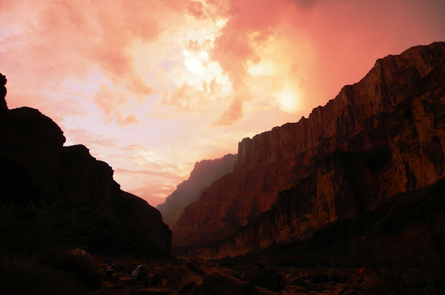
| A clearing storm in Carbon Canyon, a tributary to the Grand Canyon |
Of course, the Grand Canyon was going to appear on a list like this. It is one of the great spectacles of geology on planet Earth, and it has been entwined with my life many times over. I can trace the first inklings of my curiosity about geology to a vacation at the North Rim when I was a child of nine or ten. Picking up fossils in a meadow along the highway north of the park, I wondered how they could have ended up at 8,000 feet above sea level. A decade later I was a gawky thin teenager in his first year of college looking for direction in his life. A week below the rim on the New Hance and Grandview trails with an inspirational professor provided the impetus for following a career in geology. And then there has been the nearly three decades of leading students to this stunning place, introducing them to this most incredible gorge and the geological history it reveals. Yes, the Grand Canyon is one of the
ten most incredible places I've ever stood.
 |
| The Desert View Watchtower on the eastern edge of the South Rim of Grand Canyon. |
But there is a problem with picking the Grand Canyon as one of my "spots". It's a really big place! There are 200-plus river miles, the canyon is a mile deep and ten or fifteen miles wide, and has countless side canyons and tributaries (so many that a lot are named after their mileage along the river, i.e. Two-hundred Mile Canyon). Many of the side canyons would be national parks of their own in any other setting; Havasu Canyon and National Canyon are tens of miles long, and just as deep as the main gorge.
 |
| Mather Point, possibly. I didn't label this one! |
So do you pick the rim? This is where most people see the canyon for the first time. There are two rims of course, the North and the South. Probably 90% of the park's visitors come to the South Rim, and that is where most of the facilities are located. It has some grand viewpoints, including, um, Grandview Point. I love visiting there, but it isn't the most incredible part I've stood on.
The North Rim is distinctly different. A thousand feet higher than the South Rim, it is covered with an extensive cool forest of fir and ponderosa. It's lonelier, with a single resort, a small camper store and a campground (check out the excellent
Geogypsy Traveler blog for the perspectives of a North Rim ranger). No matter where I am on the North Rim, it feels more wild. It's one of my most cherished places in the world. But I can't pick out a single spot that I've stood on that set it apart from other areas of the canyon.
There are the archaeological sites. People have lived on and in the Grand Canyon for more than 4,000 years, and have left behind intriguing clues about their lives and beliefs, including the
split-twig figurines and multitudes of petroglyphs and pictographs. Had I not ended up a geologist, I would most certainly have followed archaeology as a career. The Grand Canyon has some great archaeology, but I couldn't pick a single spot that represents all the canyon means to me.

It took a lot of consideration, but in the end, I knew the "spot" would have to be Hance Rapids at Mile 77 on the Colorado River. So many things in my life converged at this spot. The New Hance Trail reaches the river at this point. I walked the trail in 1976 on my first geology field studies trip and stood on the shore of the Colorado River for the first time. I had walked through 1.7 billion years of earth history to reach this spot, seeing the rocks I had been studying in class for the previous two months. The history of the canyon came alive to me as I walked in wonderment, seeing the crossbedding in sandstone caused by wind blowing over dunes 300 million years ago, the footprints of pre-dinosaurian reptiles and amphibians, the ripplemarks of long-gone rivers and beaches, and fossils from times before multicelled life existed on the planet.
It is at this point that river-runners first encounter the Granite Gorge, the Inner Canyon of the Grand Canyon. The rocks are schist and gneiss 1.7 billion years old that formed in the roots of a long-gone mountain range that until recently was hidden in the deep crust of the lithosphere. Only in the last five or six million years has the Colorado River exposed these rocks to view. It was near this spot that John Wesley Powell wrote his immortal words about the Grand Canyon:
"We are now ready to start on our way down the Great Unknown...We are
three quarters of a mile in the depths of the earth...We have an unknown
distance yet to run, an unknown river yet to explore. What falls there
are, we know not; what rocks beset the channel, we know not; what walls
rise over the river, we know not."
The Great Unconformity separates these ancient rocks from the only somewhat younger rocks of the Grand Canyon Supergroup (the reddish sediments on the right in the picture below). The Supergroup is a group of late Proterozoic sediments that are
three times as thick as the main sequence of Paleozoic rocks that make the upper 4,000 feet of the Grand Canyon cliffs. They were faulted, tilted, eroded, and ultimately buried by the advancing Cambrian sea of 515 million years ago. It may be the most famous unconformity on the planet.
This was the spot where I became a geologist.
I returned to Hance Rapids last summer for the first time in thirty years, only this time I came by raft rather than by foot. I am still processing that journey in my mind, but I already know that it was one of the most significant events in my life. I became aware of the fragile nature of life, first among the plants and animals in this challenging environment, but also of my own. Aside from the profound risk of driving a car every day, I came the closest I've ever been to realizing the possibility of death when I was dumped into the near freezing water and rode the toughest rapid for more than a quarter of a mile. We went over more than 150 rapids in seventeen days, and Hance was the first of the monster rapids, rated 8 or 9 on a scale of 10.

Some pictures surfaced a couple of years ago on my Facebook page of that first profound adventure that I had in 1976. It's remarkable how little the river and the rocks have changed, but I realized how much has changed in our understanding of how the rocks of the canyon accumulated, and how the canyon itself came into being. Plate tectonics had been accepted only a few years prior to my arrival in the canyon, and the tectonic history was only just then getting worked out. Parts of the story are still mysterious.
I also realize the massive changes in my own life since then. Back then, there was a dedicated geology professor discussing the history of the canyon, and a young man making life-changing decisions in the professor's class. The young man had not yet married, there were no children in his life, he had not earned a living on his own. He was just starting out.
Today, my kids are grown, I get awards for longevity at my job, and I'm closer to the end of my career than I am to its beginning. I am a teacher now, but I continue to be a student as well, seeking out new places, and revisiting the old ones from the past for continuing enlightenment. The canyon will continue to exist, changed only in a few ways during my tenure on the planet. It knows or cares little of the latest life form that scrabbles about its surface, and it will shrug off the gigantic reservoirs we've constructed to try and control the river.
The canyon is an incredible place. It gives us perspective in so many ways, and that's why it ended up as number two on the list of the most incredible places I've ever stood.
 |
| Just who is that thin person in the yellow jacket?? |
AND...
Number 1: Road's End at the Edge of the World...Cedar Mesa, Utah (from May 15, 2014)
There's an empty quarter within the bounds of the lower 48 states. It's a vast area, a swath of land across southern Utah and northern Arizona where towns are few, and the vistas are wide. It's bounded by Blanding on the east, Mexican Hat and Kayenta to the south, and Lake Powell off to the west. Outside of these few villages there are some reservation lands and ranches. There is a national monument (Natural Bridges), and a national park off to the north (Canyonlands), but mostly it's uninhabited Bureau of Land Management land. In other words, lands held in trust for all the people of the United States.
I've been going through a list of the ten most incredible places I've ever stood. Some of these I chose because of their geological significance, and some because of their incredible scenery. A few were chosen from sheer emotion and personal spiritual reasons, and that is also the motivation for my number one choice. Not many people know of the place. It's not a national park or monument, and the geology, while interesting, is not exceptional. It's in the center of the empty quarter of Utah on the edge of Cedar Mesa. It's called Muley Point.
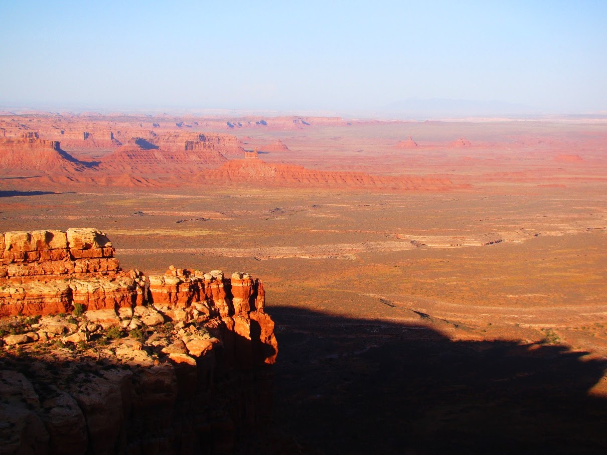
Standing on the edge of the world at Muley Point, one looks down several thousand feet into the mysterious gorge of the San Juan River, one of the major tributaries of the Colorado River. The canyon is an intricate twisting maze of curving gorges called
entrenched meanders. The river once flowed as a meandering stream channel over a flat plain relatively close to sea level. When the land rose, the gradient of the river increased, but the water was trapped in the meandering channel, so the curve was preserved as the river cut ever deeper (below).
The rocks making up the cliffs are part of the Cedar Mesa Sandstone, a Permian-aged unit that preserves some coastal sand dunes, and the occasional bone or track of some pre-dinosaurian reptile like Dimetrodon.
 |
| Entrenched meanders of the San Juan River below Muley Point |
In the distance beyond the canyon of the San Juan stand the buttes and mesas of Monument Valley, the scene of so many iconic western movies (below). The valley is administered as a tribal park of the Navajo people. The farthest horizon reveals the margin of Black Mesa, the heart of the Navajo Reservation and the home of the Hopi Nation as well. The spiky monument in the far distance just left of center is Agathla's Needle, the core of a deeply eroded volcano. This volcanic neck, or
diatreme, is similar in age and composition to the better known Shiprock a few miles away in New Mexico.
The view to the east extends across the Raplee Anticline to the Chuska Mountains of New Mexico, and the Rocky Mountains of southeastern Colorado. The scene below is taken from the top of the Moki Dugway on Utah Highway 261, the precarious road that provides access to Cedar Mesa and Muley Point.
 |
| The view east from the top of the Moki Dugway, the spectular road that provides access to Muley Point |
North from the Moki Dugway one can see the deeply incised edges of Cedar Mesa. Looking at this barren desert landscape, it is hard to accept that Cedar Mesa was once part of the "fertile crescent" of the American Southwest. An arc of land extending from Mesa Verde to Cedar Mesa was in the "sweet spot" elevation of being not too hot and not too cold and having just enough precipitation to produce high yields of maize, squash and beans. It was a thriving agricultural region for the Ancestral Puebloan people for hundreds of years. Most of the surface of Cedar Mesa was under cultivation, and thousands of archaeological sites dot the region (unfortunately making it a target for
illegal pothunters). The Puebloans moved on eight hundred years ago, and the mesa has been more or less deserted since then. The juniper and pinyon trees sprouted and covered the ancient corn fields.
Years ago I learned the craft of leading field studies with the staff and crew of Santa Barbara City College, days I remember fondly. We used to take a one-day raft trip down the San Juan River from Bluff to Mexican Hat, and the night before we would spend the night at Sand Island on the river. We would spend a few moments at Muley Point before descending to the hot, humid, and buggy campsite. One year someone pointed out that we were fully equipped to camp anywhere, so why not stay on the rim of Cedar Mesa where the view was indescribable, and the air was fresh and clean, and gloriously free of biting deerflies and mosquitoes? From that time on we camped on the edge of the world. What had been just another spot with a nice view became for me a yearly pilgrimage.

What makes this place so different? It's magic, I think. It is the top of the world, and the edge of the world. One can stand and see a vast region occupied by a mere handful of people, a land that shows little of the damage (at distance anyway) that people can do to a landscape. It's colorful and ever-changing, especially in the light of dusk or twilight. There aren't many places where one can experience the full drama of the Earth through sunset, night and sunrise, and have a completely unobstructed view of the sky from horizon to horizon to horizon.

Usually when we pull into a campsite on our field trips, the students and crew jump out, unpack, and set up their tents and the cooking area. I learned long ago that Cedar Mesa and Muley Point are different. The people emerging from their vehicles disappear. I wander along the edge of the mesa and I find them, sitting alone or in small groups, just contemplating and staring at the scene before them. I often take on the task of preparing the evening's meal just to give them more time to be out there.
I've spent a total of two weeks on the mesa over the last three decades and every night is different. We've seen warm clear days and nights, we've had windstorms (equipments blows over the edge never to be seen again), thunderstorms, and rain.
Have you ever spent an entire night taking in a special place? Have you ever watched the progression of the cosmos over hours and hours of time? We constantly insulate ourselves from the darkness, but there are certain times and places where we can revel in it. There is nothing quite like watching moonlight reach deeper and deeper into canyons below the rim. What had been featureless darkness below becomes an intricate pattern of complex beauty. I've awakened in the early hours of the morning to watch the moon setting or watching the long drama of sunrise. Some nights there are thunderstorms over the Sleeping Ute or Chuska Mountains. The fire in the sky is an incredible sight.
Sometimes there are eerie things as well. Rational people can still feel the echoes of the lives that were played out on this mesa. I've been keenly aware of the spirits that exist in and around the canyons, whether real, or constructs of the imagination. We sat on the edge of the mesa one night nearly thirty years ago and saw mysterious lights. I still to this day don't know what to make of them (and you can be sure that I've watched for their return ever since!). Yet, I've never felt scared or nervous in this place. Just curious.
The morning inevitably comes, and once the sun rises high in the sky, the mesa becomes less mysterious. We are ready for a day of seeking the Ancestral Pueblo ruins that are hidden in literally every side canyon on the mesa. Spending a night exposed to the environment that they called home enlightens our explorations.
It was hard to pick the top ten of my most incredible places, and I couldn't begin to rank them, but I do know that I might not see the Burgess Shale or the Gubbio clay layer or Siccar Point again in my life. They were memorable, and I will always cherish that fact that I got to see them. But I didn't
experience them, not in the way that I've experienced the Grand Canyon, Yosemite, and Cedar Mesa.
That's the thing I guess. Any place in this wide world can become the most incredible place you will ever stand. It won't be that tourist destination that is famous worldwide, because those are the places that you visit once or twice and never get to know. The special places are those which you experience in the fullest sense in all kinds of situations and conditions. That's what Cedar Mesa is to me.

So, what has me worried? I was digging through the tons of old topographic maps in the old department as we prepared for the move to the new Science Community Center. And I found a topo map of the Glen Canyon National Recreational Area, and noticed that a small corner of Cedar Mesa extends over the boundary of the GCNRA. Muley Point is "protected"! But in small print were the following words: "Slated for future development". Chilling words, but thus far unrealized. A paved road, interpretive signs, restrooms, and parking lots would ruin this incredible place. I hesitated about even making its presence known, but in the end I did, because unknown places are the easiest to destroy (just ask Glen Canyon). Such places will need friends in the future.
In the meantime, revel in the discovery of your own most incredible places, and if you are ever near the town of Mexican Hat, seek out Muley Point. It's not too hard to find, the road is okay for most cars even if a bit bumpy at times. And don't just look and drive away after a few minutes. Lay out a sleeping bag, find the appropriate rock (you'll know the right one), and let this place fill you. You won't regret it.
Addendum and Update:
There are disturbing developments at Cedar Mesa in recent days. In 2016 Barack Obama established Bear's Ears National Monument after years of consultation with local tribes and stakeholders. The boundaries included Cedar Mesa, providing new protections for the rich archaeological resources of the region. It was the right thing to do, but the new administration is interested only in resource extraction, mainly oil, gas and uranium. The president is trying to decrease the size of the monument by 90% (illegally).