
There's an empty quarter within the bounds of the lower 48 states. It's a vast area, a swath of land across southern Utah and northern Arizona where towns are few, and the vistas are wide. It's bounded by Blanding on the east, Mexican Hat and Kayenta to the south, and Lake Powell off to the west. Outside of these few villages there are some reservation lands and ranches. There is a national monument (Natural Bridges), and a national park off to the north (Canyonlands), but mostly it's uninhabited Bureau of Land Management land. In other words, lands held in trust for all the people of the United States.
I've been going through a list of the ten most incredible places I've ever stood, and so far in this series we have explored the Alaka'i Swamp of Kaua'i, Hawai'i, the lava flows at Pu'u O'o on the Big Island, Frame Arch in Arches National Park, the moment of global death in Gubbio, Italy, and the Burgess Shale of British Columbia. There was Siccar Point in Scotland, Kartchner Caverns of Arizona, Dante's View in Death Valley, and Hance Rapids on the Colorado River in the Grand Canyon. I also cheated a little and insinuated that Glacier Point in Yosemite was one of the ten (which it is, even if all of these add up to eleven; didn't you all see "This is Spinal Tap"?). Some of these I chose because of their geological significance, and some because of their incredible scenery. A few were chosen from sheer emotion and personal spiritual reasons, and that is also the motivation for my number one choice. Not many people know of the place. It's not a national park or monument, and the geology, while interesting, is not exceptional. It's in the center of the empty quarter of Utah on the edge of Cedar Mesa. It's called Muley Point.

Standing on the edge of the world at Muley Point, one looks down several thousand feet into the mysterious gorge of the San Juan River, one of the major tributaries of the Colorado River. The canyon is an intricate twisting maze of curving gorges called entrenched meanders. The river once flowed as a meandering stream channel over a flat plain relatively close to sea level. When the land rose, the gradient of the river increased, but the water was trapped in the meandering channel, so the curve was preserved as the river cut ever deeper (below).
The rocks making up the cliffs are part of the Cedar Mesa Sandstone, a Permian-aged unit that preserves some coastal sand dunes, and the occasional bone or track of some pre-dinosaurian reptile like Dimetrodon.
 |
| Entrenched meanders of the San Juan River below Muley Point |
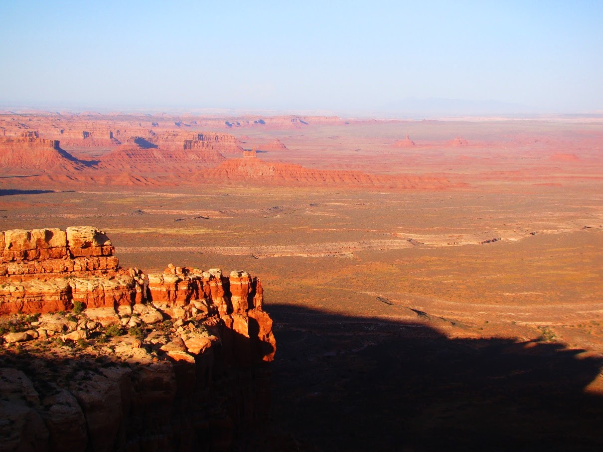
In the distance beyond the canyon of the San Juan stand the buttes and mesas of Monument Valley, the scene of so many iconic western movies (below). The valley is administered as a tribal park of the Navajo people. The farthest horizon reveals the margin of Black Mesa, the heart of the Navajo Reservation and the home of the Hopi Nation as well. The spiky monument in the far distance just left of center is Agathla's Needle, the core of a deeply eroded volcano. This volcanic neck, or diatreme, is similar in age and composition to the better known Shiprock a few miles away in New Mexico.

 |
| The view east from the top of the Moki Dugway, the spectular road that provides access to Muley Point |
North from the Moki Dugway one can see the deeply incised edges of Cedar Mesa. Looking at this barren desert landscape, it is hard to accept that Cedar Mesa was once part of the "fertile crescent" of the American Southwest. An arc of land extending from Mesa Verde to Cedar Mesa was in the "sweet spot" elevation of being not too hot and not too cold and having just enough precipitation to produce high yields of maize, squash and beans. It was a thriving agricultural region for the Ancestral Puebloan people for hundreds of years. Most of the surface of Cedar Mesa was under cultivation, and thousands of archaeological sites dot the region (unfortunately making it a target for illegal pothunters). The Puebloans moved on eight hundred years ago, and the mesa has been more or less deserted since then. The juniper and pinyon trees sprouted and covered the ancient corn fields.


Sometimes there are eerie things as well. Rational people can still feel the echoes of the lives that were played out on this mesa. I've been keenly aware of the spirits that exist in and around the canyons, whether real, or constructs of the imagination. We sat on the edge of the mesa one night nearly thirty years ago and saw mysterious lights. I still to this day don't know what to make of them (and you can be sure that I've watched for their return ever since!). Yet, I've never felt scared or nervous in this place. Just curious.


That's the thing I guess. Any place in this wide world can become the most incredible place you will ever stand. It won't be that tourist destination that is famous worldwide, because those are the places that you visit once or twice and never get to know. The special places are those which you experience in the fullest sense in all kinds of situations and conditions. That's what Cedar Mesa is to me.

In the meantime, revel in the discovery of your own most incredible places, and if you are ever near the town of Mexican Hat, seek out Muley Point. It's not too hard to find, the road is okay for most cars even if a bit bumpy at times. And don't just look and drive away after a few minutes. Lay out a sleeping bag, find the appropriate rock (you'll know the right one), and let this place fill you. You won't regret it.
PS: After I posted this, Ron Schott let me know he had a 360 degree gigapan of the view from Muley Point. Check it out at http://www.gigapan.com/gigapans/52566 !
9 comments:
OK, now I see and understand why Grand Canyon wasn't #1. I will have to look into visiting this incredible sounding place, and bring my sleeping bag.
It was a hard, HARD choice! The raft trip down the canyon had a huge impact on me and my life. Grand Canyon is truly unique and wonderful!
The first photo in your series. I landed my Cessna 182 on that road because I had to take a leak. I was on my way to Gouldings Trading Post but my bladder said no. Too much coffee for breakfast. I guess when you when you live out here and you see this scenery everyday you began to take it for granted.
"a cold, bleak, lonely day on the rim at Muley Point, Utah" E. Abbey
On January 15, 2007
"No one saw what happened next , but investigators say tire tracks and other signs at the scene show that Lin, with Yuki in the passenger seat beside him , put the vehicle in gear and drove straight toward the cliff about 100 feet away. The vehicle’s doors and windows were locked. Investigators say it appears Yuki's final moments were spent crawling from the front into the rear passenger seats. The vehicle hurled off th canyon rim, crashed head first on a ledge about 60 feet below the canyon rim , flipped onto the roof and came to its final resting spot on the ledge. It's believed Yuki and Lin died instantly. An NPS employee found the wreck 12 days later while hiking. The Park Service found no evience that Yuki participated willingly in her death."
http://nomoresecrets.utah.gov/Documents/2007%20DV%20Deaths%20list%202.pdf
Wow, Garry, wonderful photographs !
I'm seriously obsessed with Cedar Mesa Sandstone, but haven't spent as much time as I should on Cedar Mesa itself. I'm usually on my way to Escalante or Capitol Reef or the Maze. Sometimes we camp in Valley of the Gods or if it's not too stormy, Muley Point.
I'm not trying to say my favorite place is better then yours; there are so many special places in southern Utah. I just urge you to go to Chimney Rock and the Dollhouse if you haven't been there. The Maze and Dollhouse formations are all Cedar Mesa Sandstone. Marc in Albuquerque
I couldn't agree more with your number one pic. I stumbled upon this place during the pandemic... I pretty much had it all to myself.... It is an ancient place and it's called me back several times since....
I'm glad I stumbled upon your blog. Because there has been an unsolved mystery about this amazing place I'm hoping you could shed some light on... Can you please explain to me the square structures of the landscape the perfectly square stone structures that you walk on I've never seen anything like it in nature it doesn't look natural.
Can you please explain this amazing phenomenon.....thank you!
Rocks like granite and in this case sandstone are often fractured by stresses from nearby faults, or sometimes nearby intrusions when they are close to the surface and exposed by erosion. The fractures are called joints, and they often intersect at close to right angles. It is very much a natural process.
this just made me cry, it was so beauitful, meaningful and heartfelt. I am planning my first roadtrip to monument valley next week and i am so happy to have come across this piece of poetry, a love letter to the mesa <3 i cant wait to experience it for myself soon.
So enthralled to find this site. My deepest gratitude for you sharing this. Such an inspirational and beautiful description of a place that is indescribably magnificent. My first visit in 1986 was after backpacking in Grand Gulch and driving the Moki Dugway. The first evening I laid down and looked up at the beautiful sky. The next 5 minutes provided a profound, glorious once-in-a lifetime treasure. As I viewed an incomparable sunset from my right eye, my left eye notes the full moon. Still get goosebumps remembering it.
Post a Comment