This first photo may recall the disasters unfolding in the American West and Hawai'i with out-of-control wildfires and volcanic eruptions, but in this case it is no disaster. It is was the sunset on the tenth day of our recent exploration of the Colorado Plateau. We had finished our explorations of Arches and Canyonlands National Park and were headed west, towards home. It's funny, the emotions that can arise on a long journey. It felt like we were nearing the end of the trip yet we still had five days and four nights to go, and there were still four national parks on the itinerary. I've put together two previous posts of my favorite shots from the trip, and this is the third and final chapter.
We had been out for a long time, so we gave the students half a day of free time in Moab, Utah to do laundry, shower, and peruse the rock shops. But first we had one other major archaeological stop to make. The sandstone walls of the Colorado River gorge downstream of Moab contain some fascinating petroglyphs. They are cleverly hidden behind a big highway sign that says "Indian Writings".
Having signs pointing to fragile petroglyphs along a busy highway might not seem to be a good preservation strategy, but in this the highway construction itself provided the protection. There was very little space along the river for road construction, so the crews removed many tons of fallen debris to make room, the same debris the original artists stood on to chip out their art. Many of the petroglyphs are now inaccessible, fifteen or twenty feet above the roadway. One of the most unique is the bear, surrounded by hunters with bows and arrows (I think the artist was bragging).
In the afternoon we headed west and south across the barren lands around Green River. The small village is the final settlement for a hundred miles west along Interstate 70. The only settlement to the south is Hanksville, around fifty miles away. We were in one of the most isolated regions of the lower 48 states. Our destination for the night was Goblin Valley State Park on the San Rafael Swell. The sunset was glorious (the first picture of today's post was also taken there).
In Jurassic time an ocean embayment extended south from Canada into the Colorado Plateau region. Called the Sundance Sea, it left behind all manner of tidal flats, delta deposits, and coastal dunes. The Entrada Sandstone displays many of these environments, and erosion has carved the rock into a variety of fascinating shapes. For one, most of the arches of Arches National Park occur in the Entrada. At Goblin Valley, the rocks were more thinly-bedded and produced small mushroom-shaped spires that gave the valley its name. If you are a fan of sci-fi flicks, you may recognize Goblin Valley as the setting for some scenes from Galaxy Quest (the one with the little purple aliens and the rock monster).
Looking south from Goblin Valley we could see the high peaks of the Henry Mountains, often described as the last mountain range in the United States to be discovered and explored (in the 1870s). Like the La Sal Mountains described in the last post, they are laccoliths, mushroom-shaped intrusions of magma. It was at the Henry Mountains that the term laccolith was first proposed by Grove Karl Gilbert, a pioneering American geologist.
Stars. Night after night of the most starlit skies I can remember. We were in the darkest corner of the continent, and our nights for the entire trip had been free of moonlight, but the following day the thinnest crescent moon I could remember ever seeing was setting in the west. I noticed later that this first appearance of the moon on June 14 was the ending of the month of Ramadan.
Our destination the following morning was Bryce Canyon National Park. The Colorado Plateau is a remarkable region because for close to a billion years it had been remarkably stable, remaining at or close to sea level throughout Paleozoic and Mesozoic time. But in the Cenozoic this began to change as the land rose above sea level for the last time. During the early Cenozoic Era (60-40 million years ago) the region around Bryce Canyon was a huge freshwater lake. The resulting pink siltstone an limestone layer is called the Claron Formation.
The rocks of the Claron Formation are cut by vertical fractures called joints, and these fractures allow water and ice to widen the cracks and forming the spires of Bryce Canyon. The rock towers are called hoodoos. Sometimes arches and natural bridges will form during this process (natural bridges cover a watercourse while arches do not). Does anyone want to guess what kind of opening this is in the picture below? (Hint: It's named Natural Bridge)
Bryce Canyon is an exceedingly popular national park. Besides the spectacular scenery, it lies in close proximity to Zion and Grand Canyon National Parks and thus makes a "grand triangle" of a tour so beloved by bus companies and tourists on a time budget. The popularity combined with the rush that most people are in to get to the most possible localities means that certain parts of the park are more impacted than others. The free trams go to the most crowded parking lots, and the entire south end of the park tends to be far less crowded and hectic (at least in my experience). If you ever visit, make every effort to go beyond Inspiration Point and see Rainbow Point and the many other pullouts. It will take you no longer to see them than it will to wait for a parking spot to open up at the more popular viewpoints.
By the time we left Bryce that afternoon we were making serious mileage towards home. We crossed the deserts of western Utah and arrived at one of my favorite national parks of all: Great Basin. The park is not a basin, it's a mountain range, the Snake Range. It was established in 1986, although a small portion, Lehman Caves, was made a national monument in 1922. The political journey leading to the establishment of the park was different than most. As I came to understand it (and please, provide some insight in the comments if I have this wrong), there was a desire to have a national park representing the best of the Basin and Range geologic province, but promoters were split between three possible locales! There was the Toiyabe Range in central Nevada, the Ruby Range/East Humboldt Range in the northwest part of the state, and the Snake Range, which got the eventual nod. Purists supported the Toiyabe Range because it best exemplified the unique ecosystems of the Great Basin whereas the other two showed more affinities for Rocky Mountain flora. It was an interesting problem because the Ruby Mountains and Snake Range offered more "normal" mountain scenery along with glacial lakes. They really are a bit more like the Rockies. I suspect that the Snake Range got the nod because it already had the infrastructure for a national park (an extant visitor center, for instance), it had Lehman Cave as a centerpiece, but it also had Nevada's only glacier, and a forest of Bristlecone Pines, the oldest living organisms on the planet.
The park also protects Wheeler Peak (13,063 feet), which is the highest peak entirely within the boundaries of the state of Nevada (the actual high point, Boundary Peak, is a spur on the ridge of a higher peak in California, and it is only about 50 feet higher than Wheeler). There is a spectacular ridge-hugging paved road that reaches the main trailheads at over 10,000 feet.
Great Basin is one of my favorites because it still retains the character of what most national parks once were: havens of serenity and wilderness. The park is generally uncrowded (except for the lines at the visitor center for cavern tour tickets), and mostly undeveloped. There are roads and campgrounds, for instance, but many of the roads are unpaved, and the campgrounds are old style: vault toilets, and no hook-ups. The last time I checked, the campfire programs were actually done around campfires, without screens and PowerPoint presentations. I hesitate to even tell you about this because you might want to go and see it, and it will get crowded like all the rest. Just kidding, go see it. It's beautiful, and the caverns are wonderful too.
The next day was a long drive across Nevada, and we had one more night, staying at Berlin-Ichthyosaur State Park. It's a fascinating place and I would describe it in detail, but I took few pictures, and this post is all about my favorite shots from the trip (you can read some details in this post from a previous trip). The next morning we were homebound and quickly crossed the western desert hills of Nevada. We crossed Anchorite Pass and rolled into our home state of California In a matter of minutes Mono Lake came into view. We took a break at the Interagency Visitor Center at Lee Vining.
Mono Lake is a singular ecosystem in California, like no other place in the state. It occupies a large tectonic basin, meaning it has no (current) natural outlet. Lots of water flows into the lake via streams from the adjacent Sierra Nevada, but the only way water can leave is by way of evaporation. Because of this, the salt content of the lake is three times that of seawater. Few organisms can survive such conditions, so the ecosystem is pretty straightforward: some algae, trillions of brine shrimp, trillions of brine flies, and millions of migratory and resident bird species. Mono Lake is one of the most important stops on the Pacific migratory flyway.
Unfortunately humans always find a way to muck things up, and Los Angeles worked really hard to mess up this system. It involved building a 200 mile-long aqueduct and an eleven mile-long tunnel under a series of volcanoes to siphon off water from the tributaries that drain into Mono Lake. When the city closed off the streams in 1941 Mono Lake began drying up and lost 45 feet of elevation. The salinity drastically increased, threatening to kill off the shrimp. Lawsuits dragged on for years, but now an agreement is in place to raise the lake to a sustainable level. If only the California drought would cooperate...
The day we arrived the lake was (for me) an unusual shade of turquoise. The clouds were a sight as well. There had been not a great many clouds during our trip. The lack of rain was nice, but the entire route of our trip has been in the grip of an exceptionally severe drought. We wouldn't have minded a drencher if it could have helped.
Our final national park of the trip was in some ways the most familiar, but we didn't see it from a normal angle. Something like 90% of the people who visit Yosemite National Park go to the iconic valley, but the valley makes up only 7 square miles of a 1,000 square mile park. We entered the park at Tioga Pass (9,945 feet) and drove through the alpine meadows of the upper Tuolumne River. After more than 3,000 miles of barren desert environments, the greenery was stunning. We made a final lecture stop at Olmsted Point, which provided a unique view of Half Dome, from upstream.
But that was it. Once everyone realized that we had crossed the headwaters of the river that flows through our community, there was no slowing down. Homesickness is a powerful emotion and it was almost as if our vans took on a life of their own as we rolled down the western slope of the Sierra Nevada to the end of our journey. Like crazed tourists, we had visited 10 national parks, 9 national monuments and recreation areas, and maybe a dozen state parks. We had traversed a geological history encompassing 1.7 billion years of geological events and thousands of years of human history. All it took was 15 days, 3,700 miles, and a great group of students and volunteers!
Come join us some time in the future. We're headed to the Cascades this fall with a five day trip to Mt. Shasta, Lava Beds National Monument, Lassen Volcanic National Park, and McArthur-Burney Falls State Park. Contact me for details...
Showing posts with label Goblin Valley State Park. Show all posts
Saturday, July 7, 2018
Sunday, October 20, 2013
It's Just a Damned Rock...or Stalactite...or Wolf...or National Park. Where does it stop?
The subject of today's post grew out of several news items from the past few weeks, and a walk underground that I took yesterday.
I'm going to start with a bit of a mental exercise. Imagine a cavern in a place like the Sierra Nevada foothills, a cave that was discovered by miners in the 1850s, and offered up as tourist stop for the next 30 years or so. Think how attitudes about caves differed in those days. Visitors regularly broke off stalactites as souvenirs, and many carved or wrote their names on the walls. Imagine a cave where such activities continued until few speleothems (cave decorations like stalactites and stalagmites) were left, and people lost interest in visiting the site. It fell into disuse and was abandoned, forgotten by all but a few spelunkers, and even they rarely visited.
Skip forward a century or so. Spelunkers explore the cave, and find some indications of deeper passageways, maybe a pile of rubble, or perhaps a cool breeze coming from a small crack in the wall. They start removing the rubble, and realize that a narrow passage may reach into deeper recesses never discovered by the miners and early tourists. Weeks of work and they break through into a new room, a room never before seen by human eyes. A room full of stalactites and other features never broken off or smudged by soot. As a geologist and explorer of the Earth, I've dreamed of doing something like this, but I can't quite fit in the tight passages the way I used to in my youth (not to mention a sense of claustrophobia!). Luckily we can experience something like this discovery in several of California's beautiful caverns, especially Black Chasm, and the subject of today's photography, California Cavern. We visited yesterday as part of a field studies class in the Sierra Nevada foothills.
California Cavern is owned and operated privately, and some parts of the cavern system are utilized extensively for recreation, but they've done a good job of protecting the gem of a room that was discovered in the late 1980's. It's called the Jungle Room and it is full of some of the most delicate speleothems I've ever seen. The most extraordinary are the soda straws, thin long stalactites that look so delicate that a single touch could break them off. And they haven't been broken.
The tour guides spend their time in the first barren looking rooms talking about how the miners and early tourists used to use this room for court, that room for meetings and this other room for preaching or marriage ceremonies. They point out the carvings and other graffiti on the walls, but mostly what I see is destruction of anything within the reach of hands or long sticks. It is sad to think of what was lost in the inkling of time, those few years out of hundreds of thousands that humans entered into these underground openings.
I don't think that the early visitors acted out of maliciousness, just ignorance, but I am seeing a new class of people these days, destructive people who wish only to destroy, for reasons I cannot begin to fathom. I think of the arsonists who would destroy ancient forests, and people who would take advantage of a government shutdown to invade and destroy the beautiful parts of our national parks and monuments.
I wonder if that idiot Representative Randy Neugebauer, who berated a park ranger who was (unhappily) erecting barriers at one of our war memorials, gave even a moment's thought to what could have happened if the park service left the memorials unprotected and unpatrolled. All over the country, terrible people wandered into parks, leaving behind vandalized facilities and obscene messages.
Caves can sometimes be protected behind locked doors, but other caves are unprotected. Every year more damage is done. And sometimes those responsible will say things like "it's just a single damned stalactite, it's just a single rock, it's just a single wolf I shot", it's whatever someone felt justified in destroying. And since we find that corporations are "people too", we have corporations who say "it's just another damn forest, or river, or meadow" that we want to develop, or log, or mine. What will it hurt to destroy just one more?
I love seeing perfection. It happens so rarely, and it is always so fragile. That's what I was able to observe yesterday, deep inside the mountainside. Our Earth is fragile too, and we've already done so much damage.
On the way out of the cave after our tour I noticed something that I hadn't seen before. Some of the stalactites were repairing themselves! It was only the littlest change, but some of the soda straws and stalactites were growing again, and I realized that in at least some caves, the features may return, probably long after we humans have become extinct and perhaps replaced by beings with a better sense of beauty. It left me with a little bit of hope.
So I end with the morons in Utah's beautiful Goblin Valley, one of my favorite places to visit. Yeah, it's just another damned rock. Who really cares if we push it over? There are hundreds of others. What will it hurt? And besides, they were "saving lives". They are morons, maybe, and deserving of punishment. Because I love places like Goblin Valley, my first impulse is that they ought to go to prison, but on second thought, it might be better if they get a sentence of community service, hopefully teaching others the importance of protecting the wild places instead of destroying them. It's not likely that the message will sink in, but one can hope.
Tuesday, July 2, 2013
Out of America's Never-Never: Two Weeks on the Colorado Plateau
![]() |
| Sunrise in Goblin Valley State Park, Utah |
Say Never-Never Land and most people immediately think of Peter Pan and Captain Hook, but the term has an older meaning of which J.M. Barrie was probably unaware. The Never Never is a remote and largely inaccessible part of the Northern Territory and Queensland of Australia's Outback. To some, it is a place that one would "never, never" want to go (despite this neat-sounding trip). To some of those who live there, it is a place one would never, never want to leave.
I see many parallels between Australia's Outback and the American Southwest, especially the Colorado Plateau. Most of the local populations live on the margins of the region, and until recent decades anyway, many parts remained unexplored by people of European descent. To others it has been home for thousands of years. The lands are ancient, each revealing a fascinating geological story.
So welcome to America's Never Never. I've just returned from my latest journey through the wonderful landscapes of the Colorado Plateau, and although we mostly followed modern highways, we could sense the isolation and wildness that is still inherent to this country. I hope you will enjoy the journey over the next few weeks in pictures and stories.
![]() |
| Mesa Arch in Canyonlands National Park, Utah |
Wednesday, May 2, 2012
OMG! It's the SUPERMOON! The moon really is super, but...
We'll just say I'm cheating here a little bit, and am using this post to show some of my favorite moon photographs. The moon is so steeped in human psyche and mythology. It is one of those things that is with us all our lives, and is more dependable than food, shelter, or trust. It rises and falls like clockwork, and for centuries it was our clockwork, along with the sun and stars. It is as dependable as the tides, which makes sense, since it is a major cause of the tides.
And we take it for granted. We might go weeks without paying attention to it as we go about our daily lives. Honestly, unless you have seen a headline in the last few days, can you say what phase the moon is in right now? No looking...
If you have seen some headlines, the "supermoon" has arisen once again. The moon is going full on the weekend at the same moment that it is closest to the Earth. Reading the articles, one might expect that you'll be able to reach out and grab a piece of green cheese right off the surface. Like in the picture above, which I snapped on a long November journey across the Colorado Plateau (that's Black Mesa near Kayenta and Tuba City in the background).
In a case of full disclosure, here is how the moon really looked that night. A zoom lens is a wonderful tool! The moon will indeed be larger than normal this weekend...by about 14%. But a rising full moon is always a pretty sight, so I hope you will check it out.
It will look much bigger than normal as it rises above the horizon on Saturday. Philip Plait, the Bad Astronomer has provided a marvelous explanation of the optics of a big moon in this article, which I highly recommend.
Have a great weekend. Share some great pictures if you get some!
And we take it for granted. We might go weeks without paying attention to it as we go about our daily lives. Honestly, unless you have seen a headline in the last few days, can you say what phase the moon is in right now? No looking...
If you have seen some headlines, the "supermoon" has arisen once again. The moon is going full on the weekend at the same moment that it is closest to the Earth. Reading the articles, one might expect that you'll be able to reach out and grab a piece of green cheese right off the surface. Like in the picture above, which I snapped on a long November journey across the Colorado Plateau (that's Black Mesa near Kayenta and Tuba City in the background).
In a case of full disclosure, here is how the moon really looked that night. A zoom lens is a wonderful tool! The moon will indeed be larger than normal this weekend...by about 14%. But a rising full moon is always a pretty sight, so I hope you will check it out.
It will look much bigger than normal as it rises above the horizon on Saturday. Philip Plait, the Bad Astronomer has provided a marvelous explanation of the optics of a big moon in this article, which I highly recommend.
![]() |
| From Goblin Valley, Utah |
Wednesday, October 1, 2008
The Real Jurassic Parks: Goblin Valley and the Entrada Sandstone

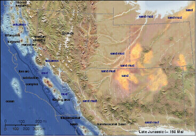
This paleogeographic map is courtesy of Ron Blakey at Northern Arizonal University
Welcome to one of the most unusual (and most isolated) parks in the American Southwest, Goblin Valley State Park. It is located in south-central Utah, miles from anywhere (the relative metropolis of Green River, population 973, is about 50 miles away). It is a fine introduction to the Entrada Sandstone and Summerville Formation, two of the more scenic layers within the San Rafael Group.
In the latest part of the middle Jurassic (around 165 million years ago) huge changes were taking place across the American west. A subduction zone had formed off the coast of California, and compressional forces had caused the faulting and uplift of a range of mountains across Nevada. A shallow sea occasionally extended into the region from the north, leaving vast deposits of mud, silt and sand deposited in tidal flats, while in other areas river floodplains and desert dunes predominated (the region still lay across the subtropical belt, much like the Sahara today). The sediments, which have a distinctive red-brown color, are known today as the Entrada Sandstone.
In other regions, the Entrada is primarily a cross-bedded sandstone that forms distinctive cliffs, but here at Goblin Valley, the formation is more variable, with alternating layers of sand, silt and shale that erode in a differential manner, forming slopes and ledges.
The Goblins are short spires called hoodoos, which resulted from the erosion along joints and fractures in the rocks. If you are a fan of the movie "Galaxy Quest", will immediately recognize the park, and will probably be looking for cute little purple cannabilistic space aliens and immense rock monsters. You will probably be disappointed in your search, but your imagination will probably conjure up even more fantastic creatures as you wander through the goblins.
The park includes a unique campground that is nicely developed with showers and flush toilets but very little shade (there is a nice group campsite too). During the summer we make a point of arriving in the late afternoon when the sun is approaching the western horizon. The views east are expansive, and few parks in the American west offer better star-gazing. The San Rafael Swell, a huge monocline, lies just to the west. The Henry Mountains, one of the last mountain ranges in the United States to be given a name, lie just to the south. Reaching over 11,000 feet, they are a series of laccoliths, a unique type of mushroom-shaped intrusion, almost, but not quite volcanoes (although volcanoes may have once existed above them). The region is also a great place for seeing pronghorn antelope!
Tuesday, September 30, 2008
The Real Jurassic Parks: The San Rafael Group
I've been meaning to return to my continuing narrative on the geology of the Colorado Plateau; I didn't want to strand you all in the early Jurassic, as pretty as the rocks of that time are. The next layers on the plateau are a highly variable series of formations from the middle Jurassic gathered together as the San Rafael Group. A lot of geologic action was taking place throughout the region at the time, with the occasional incursion of shallow seas to the region, continuing desert conditions, rivers and floodplains, and maybe even a local asteroid impact. Some of them are formidable scenery-makers, especially the Entrada Sandstone, the subject of the next few posts.Today's photo is an early morning shot from the campground at Goblin Valley State Park in south-central Utah, showing a unique outcrop pattern of the Entrada. It's a teaser, though. More later!
Subscribe to:
Posts (Atom)