Showing posts with label Castle Crags State Park. Show all posts

Tuesday, December 28, 2021

A History of the Drought in Three Pictures.


Castle Crags on December 27, 2021
It's nice to be able to report some good news once in a great while. Global warming models for California paint a truly depressing picture going forward of crippling droughts, failing snowpacks, and many tough choices to make regarding water use. We've been living those models for the past few decades with a five-year drought ending in 2017, and one of the worst drought years in history just last year. We are coming to depend more and more on the occasional intense atmospheric river events to fill reservoirs in preparation for the dry years. They've been in short supply in recent years.

My family-related travels have encapsulated the story of California's precarious water situation. The pandemic had prevented many forays north to Oregon and Washington, but we managed a trip last April, and we just completed a rather harrowing trip today. These trips were a lesson in contrasts.

We always try to take a break at Castle Crags State Park near Dunsmuir and Mt. Shasta. The granite peaks are geologically the equivalent of the Sierra Nevada, but geographically they are part of the Klamath Mountains (which were displaced west from the Sierra millions of years ago). The Crags are shorter than the adjacent Sierra Nevada, but the loftiest peaks reach 6,500 feet, which allowed for glacial erosion during the Pleistocene Ice Ages.

Castle Crags on December 18, 2021
When we visited last April, the forest surrounding the crags was frighteningly dry (below). What should have been a damp forest floor with streams swollen by meltwater was like a tinder box waiting for the spark that would ignite an inferno. Like the rest of the mountains surrounding the Central Valley, the snowpack was gone, literally 5% of a normal year. 

When we left on our trip on December 18, things were looking up a little. There had been a surprising strong storm in late October that had dropped some snow on the mountains, but warmer weather had melted much of it. A dry November left the snowpack at 19% of normal.

Then a bunch of storms coincided with our trip plans. When we stopped in at Castle Crags on December 18th, there was a delightful cover of snow on the peaks (the picture above). It seemed a promising beginning of a decent snowpack.

We were in Seattle area at the beginning of one of the biggest snow events in the city's history. We left the city on freeways so covered in ice that the lane dividers couldn't be seen, and everyone guessed (only somewhat correctly) where those lanes were. Spinouts and accidents were everywhere, and it took us nearly four hours to go the first hundred miles towards the south. We eventually outran the storm but stopped for the night in Oregon were the storm caught back up to us. 

Our next day was 380 miles of icy anxiety, but luckily the roads were clear when we reached the top of the Siskiyou Mountains and Mt. Shasta. But what huge amount of snow had fallen! Looking at the top photo in the post, you can see the high peaks were literally coated in snow.

Castle Crags on April 23, 2021
In a more official vein, the Sierra Nevada had jumped from 19% to 159% of normal snowpack in the space of three weeks (below). We've received the 52% of the total amount of snow year, with three normally wet months to go. And at least two more storms are forecast in the next ten days. It's really good news, a possible respite from the long-term drought that has been gripping the region. But it's a real mess if you have to be traveling in it.

Source: Snow Pack Conditions - Snow Water Content Chart (ca.gov)
But the snowpack is not the whole story. Reservoirs across the state reached critically low levels in two years of drought (below), and it will take more than a couple of good storms to build them up again. A heavy snowpack is great, but warm periods can prematurely melt and evaporate the ice. I'm going to stay optimistic, but my mind is telling me that this is a respite, not a solution to our problems. If we get a good water year, we will still face imminent droughts and depleted groundwater reservoirs. We need to face the problems, and not put them off. 

Source: Interactive map of water levels for major reservoirs in California | American Geosciences Institute
But it sure was nice to see all that snow!


Friday, October 5, 2018

Seeing Volcanoes from the Inside Out: A Visit to Castle Crags State Park in California

We recently completed a rather awesome trip to study the volcanoes of California, most particularly those that are found in the northern part of the state. Nearly all of our sites were the result of recent volcanic activity like Mt. Shasta, Lassen Peak, and Medicine Lake Highland, but our first visit was unique: we were exploring a volcano from the inside out!

It's not easy to visit the underside of a volcano when you think about it. The magma chamber that feeds the volcano may be four or five miles underground, and the temperatures and pressures are far, far beyond the abilities of human technology to conceivably hope to visit any time soon (there is that Unobtainium that was used in Avatar and The Core, but folks might be surprised to find it doesn't exist). About the only thing we can do is be patient. Really, really patient. First, we need to let the hot magma cool down slowly, a process that may take tens of thousands of years. Then we need to wait for a mountain-building event to cause the crust to be uplifted several miles, and then wait for the forces of erosion to remove all of the overlying rock. That's a bit longer, at least several tens of millions of years. But once it's done, the magma chamber will be sitting there, exposed for all to see. Luckily for us, this exact sequence of events took place in the Klamath Mountains of Northern California, just a few miles away from Mt. Shasta. It's a state park called Castle Crags.

The first view of Castle Crags is dramatic. Driving north on Interstate 5, one is treated to miles of forested hills, but at Castella the hills give way to sheer cliffs and spires of granitic rock. The granitic rock exposed in the Crags is the visible evidence of a magma chamber that once fed volcanoes in the along the western margin of North America in the age of dinosaurs 165 million years ago.

The sharp spires and rounded domes of the Crags are the result of having a great weight removed. Having formed at depths of four miles or more, the rocks expanded as erosion removed the heavy overlying rocks. But rocks can't expand like marshmallows; they fracture, much like the crust of baking loaves of bread. Vertical cracks are joints. Closely spaced joints promote the formation of the spires and towers of granitic rock. Fractures parallel to the surface are called exfoliation sheets. Exfoliation tends to remove to remove corners and edges, resulting in the formation of domes (Half Dome in Yosemite is a half-good example).

The Castle Crags were also glaciated, but with top elevations of less than 7,000 feet, the glaciers were small, and had less to do with the overall shape of the mountains than jointing and exfoliation. A few small lakes and moraines are found on the north side of the peaks.

We didn't have the time to hike among the trails that reach the base of the crags, but we stopped along Castle Creek to see what's been carried down the mountain by the glaciers and rivers that tear away at the granite. We could also see the more ancient metamorphic rocks that had been intruded by the granitic rock.


Seen from above (the picture below was taken on a lucky day flying home from Canada a few years back), the Castle Crags can be seen as isolated mass of granitic rock. In our geology textbooks, we find that a batholith is a single intrusion exposed over an area of 100 square kilometers (about 40 square miles). The term can also refer to a vast agglomeration of many dozens of adjacent plutons, as is the case in the Sierra Nevada. There are several of these composite batholiths in the western United States, including the Sierra Nevada, the Idaho, and the Southern California batholiths. The Castle Crags and other small isolated plutons are referred to as stocks. The surrounding rocks are the more easily eroded metamorphic rocks of the Eastern Klamath Terrane (the Trinity Complex).


We finished our subterranean exploration of the ancient volcano and headed back to the Earth's surface to find a more modern version of a volcano: Mt. Shasta. More on that incredible mountain in the next post.

Monday, December 23, 2013

Four Terrifying Pictures from Northern California

Here are a couple of scenes from our road trip this Christmas. Does the tagline seem a bit incendiary? It should be. Sure, there are three pictures of active volcanoes, but that isn't what makes them scary. We are looking at Mt. Shasta, the 14,000 foot high volcano that looms over northern California (above), and Shastina, the parasitic cone on Shasta's flank (below). What's terrifying? It's late December, and there is only a light dusting of snow. This mountain should be coated in snow from the high peaks to the low flanks. The road I was on should have been closed by snow drifts.
California is in the midst of a three year drought that shows no signs of abating. By some accounts, the last twelve months have been the driest in the state's history since at least 1895. They are having to fight fires in December in places like Big Sur, a region that should get feet of rain each year. Two years ago, I was able to drive over Tioga Pass, 9,950 feet high, after New Year's Day.
Castle Crags State Park in the Klamath Mountains. These should be covered in snow too.
A worrisome pattern is developing. Three bad years in a row, and in the desert southwest, thirteen years of drought. Some climate scientists are suggesting that we may have to adapt to a megadrought, an event that has happened here twice in the last thousand years. These droughts lasted decades, and caused huge changes in places like Mono Lake and Lake Tahoe. Entire rivers dried up. I hope that won't be the case, but are we prepared in any way to deal with it if that is the case?
A snow-free Mt. Lassen from near Redding

I hope it isn't what's going on. I hope that a whopper of a storm will move in, and that we will get a breather from the dry conditions. But we need to be ready if it doesn't. Some hard choices may have to be made.

Saturday, September 28, 2013

Seeing Volcanoes Inside and Out: Exploring California's Volcanoes

Our just completed exploration of Northern California's Volcanoes was a fascinating journey through the interior and exterior of several volcanoes. How do you explore the innards of a volcano? On the one hand, you can do a Brendan Fraser and fall thousands of feet or miles into a volcano ("Journey to the Center of the Earth", a movie I appreciated mostly for the living trilobite in the opening scene). Or...you can wait for the volcano to go extinct, be uplifted and eroded for millions of years, and then be established as Castle Crags State Park, and go stand at the viewpoint at the end of the park road. We chose the latter.

The Castle Crags are an especially scenic part of the Klamath Mountains province, a region tucked between the Coast Ranges and the Cascades at the north end of the Great Valley (I've written about them previously, click here to see). Most of the Klamaths are composed of dark colored metamorphic rocks, many of them derived from the mantle, but at Castle Crags the rocks are different. The light colored cliffs are composed of granitic rock (mainly granodiorite, a plutonic rock containing lots of plagioclase feldspar), dating back to around 160 million years ago. The granodiorite was once molten, feeding volcanoes that would have existed several miles above where we were standing. Some of the magma remained in crust, cooling slowly and allowing for the growth of visible crystals. Standing among the granitic towers of Castle Crags is to be standing in the interior of a volcano.
The dramatic spires are the result of exposure at the Earth's surface, and the resulting release of pressure (remember that these rocks formed at a depth of three or four miles in the crust). As the pressure is released, the rock expands and fractures, sometimes in vertical cracks called joints. The joints are exploited by water and ice, leading to the erosion of the steep sharp cliffs.
Sometimes the expansion of the granitic rock is outwards, parallel to the surface of the cliff. This causes fractures that act to remove corners and edges, resulting in dome-like cliffs, much like those found in Yosemite and elsewhere in the Sierra Nevada. This process is called exfoliation.

Even as we stood at the viewpoint appreciating the underside of a volcano, we could turn to our right and see a rather astounding view of the outside of a volcano. A very big volcano. Mt. Shasta is the second tallest peak in the Cascades Range, exceeded only by Mt. Rainier, but it is the most voluminous stratovolcano in the Cascades, and perhaps even the world.
At 14,179 feet, it dominates the scenery from all directions in Northern California. A stratovolcano is composed of alternating layers of ash and lava, but the details of Shasta's structure contradict that description. It is actually the remnant of at least five different volcanoes which developed on more or less the same site. The term "composite cone" is perhaps a more accurate moniker.

Shasta was our next stop of the day. At over 14,000 feet, no roads approach the summit, but in years past a ski area had been constructed at the 8,000 foot level on the south side of the peak. The ski resort was removed long ago because of avalanche danger (a wide swath of fallen trees highlights the hazard), but the paved road remains.

We took the highway out of Mt. Shasta City and headed up the mountain...

Thursday, September 22, 2011

Searching for the Perfect Volcano...And visiting some state parks for the last time

It's September, the start of a new semester, and time for a last stab at field work in the high country! I'm heading out with one or two dozen students for an exploration of the California Cascades, the southern end of major chain of volcanoes that includes such luminaries as Mt. Rainier, Mt. St. Helens, Crater Lake, and Mt. Hood. We will be taking an in-depth look at Lassen Peak, Mt. Shasta, and Medicine Lake Highland, some of the most intriguing volcanoes to be found anywhere.

We will also be taking a last look at a couple of California's state parks that are slated to close within a matter of weeks. For the lack of less than a dollar from each resident of the state, we are losing 70 of our state treasures, including Woodson Bridge State Recreation Area, and Castle Crags State Park above the Sacramento River in the Klamath Mountains. I hope to be posting some new pictures of what we are about to lose of our state heritage because of the dereliction of duty by our state legislators.

I'll be out of touch for a few days, but you might watch for updates on Twitter: @Geotripper.

Sunday, July 3, 2011

A Convergence of Wonders: Journeys in the Pacific Northwest, Day One

A Convergence of Wonders is a chronicle of our recent journey through the Pacific Northwest and Northern Rocky Mountains. This the first day's story...
I'm shaken to wakefulness by the insistent alarm going off. Oh jeesh, what time is it? 5 AM? What time did I go to bed? 2? There was so much to be done, getting ready to get two dozen people on the road for two weeks. We never really finished packing our own stuff until the wee hours. I shake off the cobwebs, and we head across the farmlands to pick up the van on west campus, and meet up with the others. Of course, I was the last to arrive, four or five minutes late.

There is a lot of adrenaline in the first moment of a trip; it's all that we could think about over the last few months, and the moment of departure has arrived. Everyone looks wide awake and ready to go. Fortunately, there is a cure for this: California's Central Valley. For the first 200 miles we drive across the monotonous fields and plains, and I have a hard time finding much to say by way of commentary. Two hours brings us to a rest area for a short break, and another two hours gets us to the first gasoline stop in Anderson. The landscape has been shifting, and snowcapped peaks appear on the skyline.
One peak in particular stands out, directly ahead of us. Mt. Shasta (14,179 feet; 4,322 m) is the highest volcano in California, and is only 300 feet short of being the highest mountain in the state. It is our first destination for the day. We see it more than three hours before we arrive at the end of the road on the flanks of the mountain at around 7,000 feet.

Something had been worrying me in the last few weeks. One has to plan a trip like this a year in advance, and sometimes we make choices that looked good on paper at the time, but which are more questionable at the moment of truth. Late June is often a good time to explore the northwest, but a heavy snow year and a cool spring were unpredictable back in January. There was a lot of snow on the peak, and presumably on mountains all across the route ahead.
And indeed, although the road was open, there was still a lot of snow in evidence. Eight feet of it! Not for the first time, I was forced to say "imagine that the rocks" while describing an outcrop covered by the white stuff.
Still, it was beautiful, the day was clear, and we could see forever...

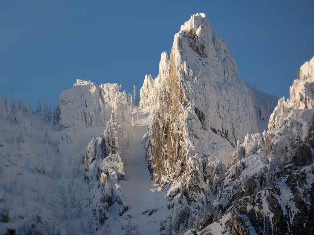
One very sad view was to the south. The alpine crags in the distance were the Castle Crags, one of the state parks slated to close soon because of the California budget crisis. It irritates me that Republicans consider it more important to protect their rich benefactors than to find the $22 million to keep 70 state parks open. The granite peaks are a dramatic sight for travelers on Interstate 5, and closing park will prevent access to a marvelous outdoor classroom.
I was growing concerned that we would be seeing a few too many signs like this...
Mt. Shasta is a magnificent mountain. It was our first introduction to the volcanic peaks of the Cascade Range, which formed as a result of convergence in the Cascadia Subduction Zone, which lies off the coast of Northern California, Oregon and Washington. It is a few hundred feet shorter than Mt. Rainier but is the most voluminous of all the Cascades volcanoes. Seen from the north, it is clear that Shasta can be considered a composite cone, with at least four previous incarnations over the last half million years. The highest peak is the Hotlum Cone, which formed within the last 9,000 years. Shastina, on the right, developed in a series of eruptions around 9,800 years ago. The short peak in the middle is an eroded crater rim of Misery Hill, which is a much older cone. California's longest glacier, Whitney, flows between Hotlum and Shastina. It is about two miles long.
Shasta was a looming presence for most of our day. Late in the afternoon, it still was visible off to the southwest as we approached our camp at Lava Beds National Monument.
We arrived about 6 PM in our camp at the Lava Beds Research Center. The camp looks sort of barren and austere, but the view was spectacular. We could see across the Tulelake Valley to peaks on the horizon many tens of miles away. We ate a quick picnic dinner, and the students outfitted themselves for an early evening exploration of some of the local lava tubes (more on these in the next post). Having already proved over the years that I could crawl on my belly through lava tubes, I chose to sit back and enjoy the coming sunset.
If roads closed by snow were a bad omen, then the sunset was a good one...the sky turned golden as the sun broke through the stratus clouds overhead.
The stratus clouds started to dissipate, and began glowing...
And then for a few moments, the whole horizon seem to catch fire.
It was a beautiful ending of the day, but the show wasn't over. It was the night of the full moon, and the glowing orb soon rose over the flank of a nearby cinder cone
Our first day on the road was ended! Tomorrow we would be exploring Lava Beds National Monument. More in the next post...

Monday, May 16, 2011

California's Shame: Closing Castle Crags to save tax breaks for the Rich

There is a budget crisis in California, due largely to a crippling recession, but also because a certain political party has decided that NO issue is important enough to talk about raising taxes on the richest members of our society, or that we must not continue to pay taxes and fees that we are already paying. To give you sense of what is at stake (and don't even ask me about education, health care, police and firefighters) I am reposted a few of my explorations of some of California's best places: the state parks. This episode of the Other California was originally posted last year on April 11...


Driving on Interstate 5 north of Redding is a sometimes terrifying affair. The highway follows the Sacramento River in a winding canyon with plenty of twists and turns. The terror isn't necessarily the road itself as much as it is the giant trucks and recreational vehicles which are being driven as if they were still on a straight freeway in the Central Valley. They don't exactly stick to their lanes. The other hazard comes from following geologists on their way north to see Mt. Shasta: at a particular loop on the highway near Dunsmuir, they are very likely to slam on the brakes as the Castle Crags come into view...

This is part of my continuing series on the "Other California", an exploration of those wonderful parts of our state that don't always show up on the postcards. Today we are wrapping up a journey through the Klamath Mountains. It has not been an exhaustive survey as it is one of the corners of the state that I have yet to fully explore. I want to reiterate my invitation: be a geotripper geoblogger! Have you been to Shasta Caverns? Backpacking in the Trinity Alps? Explored any gold mines near Weaverville or Shasta City? Write a short narrative, or if you don't trust your writing skills, just send some nice pictures, and I will find something to say.

The Castle Crags are certainly a shock when first seen from Interstate 5. The light-colored cliffs rise 3,000-4,000 feet above the river canyon, and stand in stark contrast to the lower heavily forested ridges that make up most of the surrounding area. The peaks and domes remind some people of the Sierra Nevada, and the comparison is apt; the Crags are composed of granitic rock, and as noted previously, the Klamaths are a northern extension of the Sierra Nevada. Their geologic history is similar, with one big difference: the Sierra range is composed mainly of granite intrusions (plutons), but in the Klamath Mountains, the intrusions are smaller and isolated from each other.

A batholith is a single intrusion exposed over an area of 100 square kilometers (40 square miles), although the term can also refer to a vast agglomeration of many dozens of adjacent plutons, as is the case in the Sierra Nevada. There are several of these composite batholiths in the western United States, including the Sierra Nevada, the Idaho, and the Southern California batholiths. The Castle Crags and other small isolated plutons are referred to as stocks. The limited areal extent of the Castle Crags pluton is apparent in the photo below. The surrounding rocks are the more easily eroded metamorphic rocks of the Eastern Klamath Terrane (the Trinity Complex).

The rocks of the Castle Crags formed about 163 million years ago when the Pacific Plate sank beneath the edge of the North American continent in an extensive subduction zone (the same kind of subduction that produces the Cascades volcanoes in the present day). Water released from the descending plate acted like a catalyst leading to the melting of rock deep in earth's interior, and the resulting magma bodies rose until they lay just a few miles beneath the surface. The rock cooled slowly, over tens of thousands of years, forming granodiorite (a coarse-grained granitic rock with significant amounts of plagioclase feldspar). At times, magma reached the surface producing volcanic eruptions, but the volcanoes at Castle Crags have long been worn away. In other words, standing on the granitic rock of the peaks here, one is actually perched under a long-gone volcano.

The sharp spires and rounded domes of the Crags are the result of having a great weight removed. Having formed at depths of three miles or more, the rocks expanded as erosion removed the heavy overlying rocks. But rocks can't expand like marshmallows; they fracture, much like the crust of baking loaves of bread. Vertical cracks are joints. Closely spaced joints promote the formation of the spires and towers of granitic rock. Fractures parallel to the surface are called exfoliation sheets. Exfoliation tends to remove to remove corners and edges, resulting in the formation of domes (Half Dome in Yosemite is a half-good example).

The Castle Crags were also glaciated, but with top elevations of less than 7,000 feet, the glaciers were small, and had less to do with the overall shape of the mountains than jointing and exfoliation. A few small lakes and moraines are found on the north side of the peaks.

Castle Crags State Park honors the Castle Crags, but does not actually encompass them. The park boundaries include the heavily forested southern and eastern flanks of the crags, and part of the Sacramento River, but the granitic cliffs and domes are protected as the Castle Crags Wilderness Area, administered by Shasta-Trinity National Forest. The state park offers a nice campground, with several trailheads that provide access to parts of the wilderness, as well as 8 miles of the Pacific Crest Trail. A park road leads to a spectacular viewpoint that takes in the Crags and nearby Mt. Shasta.

Vennum, Walter, 1980, Petrology of the Castle Crags pluton, Klamath Mountains, California: Summary, GSA Bulletin; v. 91; no. 5; p. 255-258.

Vennum, Walter, 1994, Castle Crags, California Geology, March/April, pages 31-38.

Sunday, April 11, 2010

The Other California: Taking Stock of the Castle Crags


Driving on Interstate 5 north of Redding is a sometimes terrifying affair. The highway follows the Sacramento River in a winding canyon with plenty of twists and turns. The terror isn't necessarily the road itself as much as it is the giant trucks and recreational vehicles which are being driven as if they were still on a straight freeway in the Central Valley. They don't exactly stick to their lanes. The other hazard comes from following geologists on their way north to see Mt. Shasta: at a particular loop on the highway near Dunsmuir, they are very likely to slam on the brakes as the Castle Crags come into view...

This is part of my continuing series on the "Other California", an exploration of those wonderful parts of our state that don't always show up on the postcards. Today we are wrapping up a journey through the Klamath Mountains. It has not been an exhaustive survey as it is one of the corners of the state that I have yet to fully explore. I want to reiterate my invitation: be a geotripper geoblogger! Have you been to Shasta Caverns? Backpacking in the Trinity Alps? Explored any gold mines near Weaverville or Shasta City? Write a short narrative, or if you don't trust your writing skills, just send some nice pictures, and I will find something to say.

The Castle Crags are certainly a shock when first seen from Interstate 5. The light-colored cliffs rise 3,000-4,000 feet above the river canyon, and stand in stark contrast to the lower heavily forested ridges that make up most of the surrounding area. The peaks and domes remind some people of the Sierra Nevada, and the comparison is apt; the Crags are composed of granitic rock, and as noted previously, the Klamaths are a northern extension of the Sierra Nevada. Their geologic history is similar, with one big difference: the Sierra range is composed mainly of granite intrusions (plutons), but in the Klamath Mountains, the intrusions are smaller and isolated from each other.

A batholith is a single intrusion exposed over an area of 100 square kilometers (40 square miles), although the term can also refer to a vast agglomeration of many dozens of adjacent plutons, as is the case in the Sierra Nevada. There are several of these composite batholiths in the western United States, including the Sierra Nevada, the Idaho, and the Southern California batholiths. The Castle Crags and other small isolated plutons are referred to as stocks. The limited areal extent of the Castle Crags pluton is apparent in the photo below. The surrounding rocks are the more easily eroded metamorphic rocks of the Eastern Klamath Terrane (the Trinity Complex).

The rocks of the Castle Crags formed about 163 million years ago when the Pacific Plate sank beneath the edge of the North American continent in an extensive subduction zone (the same kind of subduction that produces the Cascades volcanoes in the present day). Water released from the descending plate acted like a catalyst leading to the melting of rock deep in earth's interior, and the resulting magma bodies rose until they lay just a few miles beneath the surface. The rock cooled slowly, over tens of thousands of years, forming granodiorite (a coarse-grained granitic rock with significant amounts of plagioclase feldspar). At times, magma reached the surface producing volcanic eruptions, but the volcanoes at Castle Crags have long been worn away. In other words, standing on the granitic rock of the peaks here, one is actually perched under a long-gone volcano.

The sharp spires and rounded domes of the Crags are the result of having a great weight removed. Having formed at depths of three miles or more, the rocks expanded as erosion removed the heavy overlying rocks. But rocks can't expand like marshmallows; they fracture, much like the crust of baking loaves of bread. Vertical cracks are joints. Closely spaced joints promote the formation of the spires and towers of granitic rock. Fractures parallel to the surface are called exfoliation sheets. Exfoliation tends to remove to remove corners and edges, resulting in the formation of domes (Half Dome in Yosemite is a half-good example).

The Castle Crags were also glaciated, but with top elevations of less than 7,000 feet, the glaciers were small, and had less to do with the overall shape of the mountains than jointing and exfoliation. A few small lakes and moraines are found on the north side of the peaks.

Castle Crags State Park honors the Castle Crags, but does not actually encompass them. The park boundaries include the heavily forested southern and eastern flanks of the crags, and part of the Sacramento River, but the granitic cliffs and domes are protected as the Castle Crags Wilderness Area, administered by Shasta-Trinity National Forest. The state park offers a nice campground, with several trailheads that provide access to parts of the wilderness, as well as 8 miles of the Pacific Crest Trail. A park road leads to a spectacular viewpoint that takes in the Crags and nearby Mt. Shasta.

Vennum, Walter, 1980, Petrology of the Castle Crags pluton, Klamath Mountains, California: Summary, GSA Bulletin; v. 91; no. 5; p. 255-258.

Vennum, Walter, 1994, Castle Crags, California Geology, March/April, pages 31-38.