Showing posts with label batholith. Show all posts

Friday, October 5, 2018

Seeing Volcanoes from the Inside Out: A Visit to Castle Crags State Park in California

We recently completed a rather awesome trip to study the volcanoes of California, most particularly those that are found in the northern part of the state. Nearly all of our sites were the result of recent volcanic activity like Mt. Shasta, Lassen Peak, and Medicine Lake Highland, but our first visit was unique: we were exploring a volcano from the inside out!

It's not easy to visit the underside of a volcano when you think about it. The magma chamber that feeds the volcano may be four or five miles underground, and the temperatures and pressures are far, far beyond the abilities of human technology to conceivably hope to visit any time soon (there is that Unobtainium that was used in Avatar and The Core, but folks might be surprised to find it doesn't exist). About the only thing we can do is be patient. Really, really patient. First, we need to let the hot magma cool down slowly, a process that may take tens of thousands of years. Then we need to wait for a mountain-building event to cause the crust to be uplifted several miles, and then wait for the forces of erosion to remove all of the overlying rock. That's a bit longer, at least several tens of millions of years. But once it's done, the magma chamber will be sitting there, exposed for all to see. Luckily for us, this exact sequence of events took place in the Klamath Mountains of Northern California, just a few miles away from Mt. Shasta. It's a state park called Castle Crags.

The first view of Castle Crags is dramatic. Driving north on Interstate 5, one is treated to miles of forested hills, but at Castella the hills give way to sheer cliffs and spires of granitic rock. The granitic rock exposed in the Crags is the visible evidence of a magma chamber that once fed volcanoes in the along the western margin of North America in the age of dinosaurs 165 million years ago.

The sharp spires and rounded domes of the Crags are the result of having a great weight removed. Having formed at depths of four miles or more, the rocks expanded as erosion removed the heavy overlying rocks. But rocks can't expand like marshmallows; they fracture, much like the crust of baking loaves of bread. Vertical cracks are joints. Closely spaced joints promote the formation of the spires and towers of granitic rock. Fractures parallel to the surface are called exfoliation sheets. Exfoliation tends to remove to remove corners and edges, resulting in the formation of domes (Half Dome in Yosemite is a half-good example).

The Castle Crags were also glaciated, but with top elevations of less than 7,000 feet, the glaciers were small, and had less to do with the overall shape of the mountains than jointing and exfoliation. A few small lakes and moraines are found on the north side of the peaks.

We didn't have the time to hike among the trails that reach the base of the crags, but we stopped along Castle Creek to see what's been carried down the mountain by the glaciers and rivers that tear away at the granite. We could also see the more ancient metamorphic rocks that had been intruded by the granitic rock.


Seen from above (the picture below was taken on a lucky day flying home from Canada a few years back), the Castle Crags can be seen as isolated mass of granitic rock. In our geology textbooks, we find that a batholith is a single intrusion exposed over an area of 100 square kilometers (about 40 square miles). The term can also refer to a vast agglomeration of many dozens of adjacent plutons, as is the case in the Sierra Nevada. There are several of these composite batholiths in the western United States, including the Sierra Nevada, the Idaho, and the Southern California batholiths. The Castle Crags and other small isolated plutons are referred to as stocks. The surrounding rocks are the more easily eroded metamorphic rocks of the Eastern Klamath Terrane (the Trinity Complex).


We finished our subterranean exploration of the ancient volcano and headed back to the Earth's surface to find a more modern version of a volcano: Mt. Shasta. More on that incredible mountain in the next post.

Tuesday, December 6, 2011

Revisiting the Other California:The Story of the Pine Creek Mine From Someone Who Was There

I've been in a few abandoned mines, and I've taken the (recently discontinued) tourist tour at the Sutter Mine in the Sierra Mother Lode, but I've never really gotten to know the experience of working in a hardrock mine. In May of 2010, I wrote a post on Pine Creek Canyon in the eastern Sierra and the tungsten mine that operated up there for many years. A former employee at the mine, John Sullivan, saw the post and sent me a note relating his experiences working underground at Pine Creek. He has graciously allowed me to reproduce his narrative, which appears below. Thank you very much, John!

My original post follows John's note below...

"I recently discovered on your web site your fine description and photos of Pine Creek canyon and information on the mining operation once there. Amazingly, until reading your site, I did not know of the canyon’s remarkable depth statistic even though I lived in it (at the mining camp Scheelite on your map) while in grammar school in the 1950s and later climbed to the top of Mt. Tom (on the south side) and stood atop Wheeler Ridge (on the north side). Your site brought back a lot of memories.

When a house became vacant, my family moved from Scheelite down to Rovana (the major company housing) not far below the canyon mouth. My mining engineer father who leaned toward chemistry oversaw the project that developed a way to make purer tungsten concentrate at the mill.

In the summers after I turned 18 I worked at the mill (on the “bull gang” and helped run the warehouse). Later I spent summers and Christmas vacations at the mine as an engineer and geologist’s aide, helping measure the “cubes broke” each week by the two-man drilling teams (they were paid as “gypo miners” by the cubic foot of ore they brought down or the progress they made advancing a new drift). With the geologists I helped map the underground ore body –the “Pine Creek Pendant” – contact zone as it ran upward. Some days we’d be outside, 4-wheeling then hiking up to map the contact where it reached the surface of Wheeler Ridge. While surveying, you could look up from the transit east over the White Mountains into Nevada, north and south along the crest of the Sierras, at the imposing Bear Creek Spire to the west, and down at Round Valley where we’d gone to grammar school and further out to Bishop in the haze of the little sawmill’s smoke.

I’ll never forget being underground on mornings after blasting, first using a heavy “slag bar” to bar down dangerous loose rock* from the “back” (top) of the drifts and stopes, then washing off the muck and dust with a high-pressure water hose and being the first person on earth to see a new underground scene – quartz crystals, slippery molybdenite, rust brown tactite, patches of white scheelite that would fluoresce later under the geologist’s lamp. We’d go back out to the“engineers shack” and spend the next day drawing maps, merging our underground measurements with those from diamond drill cores so the geologists could keep the mining efficiently aimed upward

Home, down at camp, trucks crawled up the road day and night, hauling ore to the mill from little mines all over eastern California and Nevada. Buses went “up the hill” with men working at the mine and mill three shifts a day, seven days a week. Hardly any of our mothers worked outside the home. It was a prosperous time. It was hard rock mining. Sierra mining."

*My buddy Ron with a couple of beers after work liked to recite a slightly lyrical admonition from the company underground safety regulations:“…if you find loose rock, bar it down. If you can’t bar it down, stull it up. If you can’t stull it up, blast it down." He did become a mining engineer.

John H. Sullivan, Sacramento

What follows is the original post from May 6, 2010:
Welcome to the Other California, an exploration of the geologically fascinating places in our state that don't normally show up on the postcards.

Imagine a canyon one or two thousand feet deeper than the Grand Canyon, twice as deep as Yosemite Valley, a glacially carved trough surrounded by dramatic mountain peaks reaching almost 14,000 feet into the sky. A canyon filled with remarkable exposures of granitic and metamorphic rocks that serve as a microcosm of the geology of the entire Sierra Nevada. Such a canyon would be Pine Creek, on the eastern side of the Sierra Nevada a few miles northwest of the town of Bishop. It's a spectacular place to visit and appreciate geology.
A paved road provides easy access to many of the most outstanding features, but despite the incredible scenery, this canyon has no campgrounds, no roadside stops, no picnic areas, and no resorts. Nothing more than a small pack station at the head of the canyon. What's going on that such a place could be ignored?
I suppose it has something to do with the exposure seen below. What can be seen on this stunning cliff is the contact where the massive granite intrusions melted and forced their way into the previously existing sedimentary and volcanic rocks. The older rocks formed in Paleozoic time, around 300-400 million years ago, while the granitic rocks intruded around 100 million ago. Why would this cause tourists and explorers to ignore this place? Mineralization would be the answer. Silica-rich liquids from the magma forced their way into the metamorphic marble, reacting and forming ores of tungsten, molybdenum, and copper. This canyon was for many years a major mining center, and huge trucks were constantly driving the canyon road, which kind of interrupted the communion with nature that other visitors might have been seeking.

I walked through the area in 1975 on a trek from Yosemite to Mt. Whitney. It was kind of jarring to hike through a beautiful canyon and end up in the middle of a dusty mining complex. I'm not one to say that all mining is evil and environmentally terrible. I don't see a lot of use for gold, for instance, but tungsten was used to make the filaments in incandescent light bulbs, and I used those (it is used in wartime for armor plating on tanks, and armor-piercing bullets). If we use a resource, we have to make choices about how we will get it. We would hope as a society that the mining is done in such a way as to avoid the worst impacts (offshore oil drilling comes to mind...) on our environment.
The Pine Creek Tungsten Mine was an extraordinary operation. Begun in 1918, the mine operated until 2001, producing (along with the Climax mine in Colorado) 93% of the tungsten produced in the United States as of 1977. Low cost imports led to the mothballing of the mine in 2001 although the operation remains in place should prices rise, or strategic concerns cause an increase in demand for domestic sources of tungsten (China provides most of our tungsten at this time). The main ore is scheelite, a calcium tungstate mineral that is notable for its intense fluorescence in ultraviolet light.
The mine itself was a technological achievement. Most mines go down into the ground, but the ore here extended to 12,000 feet up into the adjacent peak. Miners could enter the mine at 8,000 feet and work some 4,000 feet higher up in the mountain.
There is lots more to see in the canyon, including the outstanding basaltic dikes that cross the granitic rocks. The granite cliffs soar thousands of feet above.
If you ever have a need to explain the term talus to someone, you can't get much of a better example than the one seen below at the entrance to the main gorge. The slopes are made of jointed granite, and whenever temperatures drop below freezing, ice can form in the spaces, pushing the rocks apart and down the steep slopes.
The U-shaped trough and hanging valleys of Pine Creek bespeak the passage of glaciers. Pine Creek Canyon is one of the classic localities for understanding the sequence and intensity of glaciations in the Sierra Nevada. It is one of the southernmost sites in the Sierra Nevada where the Tioga (14,000-28,000 years) and Tahoe (135,000-165,000 years) glaciers extended beyond their canyon and onto the adjacent valley floor. The picture below shows a ground view of the prominent lateral moraines, but the relationships are far clearer from above, as seen in the GoogleEarth image below.
One or more major earthquakes have struck within the last 14,000 years, because the young Tioga moraines are offset several tens of feet where the fault crosses the canyon entrance (marked below). Earthquakes are a serious threat in the Owens Valley; one of the biggest to ever hit the state in historic time was the Lone Pine Earthquake in 1872. It killed 28 people, and knocked rock pinnacles loose as far away as Yosemite Valley (as memorably noted by John Muir: "It is always interesting to see people in dead earnest, from whatever cause, and earthquakes make everybody earnest").
Don't be put off by the presence of a shuttered mine! Pine Creek is a great place to visit, for the scenery, and for the geology (it was a main stop during our recent NAGT-NESTA field conference). Several trails start at roads end, including Pine Creek Pass which provides access to the John Muir Trail and the western Sierra Nevada.

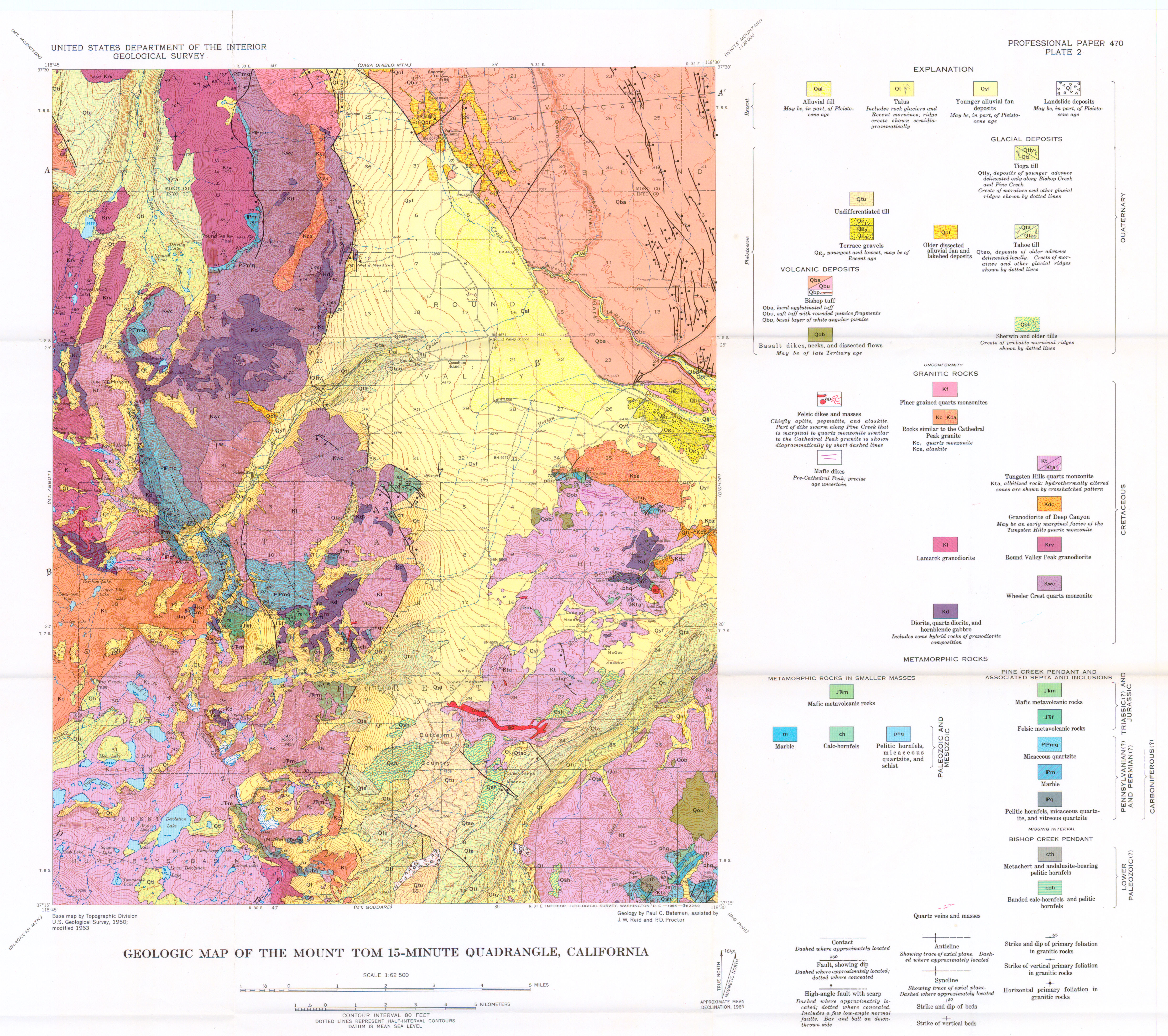
A geologic map of Pine Creek can be found here: http://geomaps.geosci.unc.edu/quads/fulls/Mount%20Tom.jpg

Thursday, May 6, 2010

The Other California: A Gorge Deeper Than Grand Canyon

Welcome to the Other California, an exploration of the geologically fascinating places in our state that don't normally show up on the postcards.

Imagine a canyon one or two thousand feet deeper than the Grand Canyon, twice as deep as Yosemite Valley, a glacially carved trough surrounded by dramatic mountain peaks reaching almost 14,000 feet into the sky. A canyon filled with remarkable exposures of granitic and metamorphic rocks that serve as a microcosm of the geology of the entire Sierra Nevada. Such a canyon would be Pine Creek, on the eastern side of the Sierra Nevada a few miles northwest of the town of Bishop. It's a spectacular place to visit and appreciate geology.
A paved road provides easy access to many of the most outstanding features, but despite the incredible scenery, this canyon has no campgrounds, no roadside stops, no picnic areas, and no resorts. Nothing more than a small pack station at the head of the canyon. What's going on that such a place could be ignored?
I suppose it has something to do with the exposure seen below. What can be seen on this stunning cliff is the contact where the massive granite intrusions melted and forced their way into the previously existing sedimentary and volcanic rocks. The older rocks formed in Paleozoic time, around 300-400 million years ago, while the granitic rocks intruded around 100 million ago. Why would this cause tourists and explorers to ignore this place? Mineralization would be the answer. Silica-rich liquids from the magma forced their way into the metamorphic marble, reacting and forming ores of tungsten, molybdenum, and copper. This canyon was for many years a major mining center, and huge trucks were constantly driving the canyon road, which kind of interrupted the communion with nature that other visitors might have been seeking.

I walked through the area in 1975 on a trek from Yosemite to Mt. Whitney. It was kind of jarring to hike through a beautiful canyon and end up in the middle of a dusty mining complex. I'm not one to say that all mining is evil and environmentally terrible. I don't see a lot of use for gold, for instance, but tungsten was used to make the filaments in incandescent light bulbs, and I used those (it is used in wartime for armor plating on tanks, and armor-piercing bullets). If we use a resource, we have to make choices about how we will get it. We would hope as a society that the mining is done in such a way as to avoid the worst impacts (offshore oil drilling comes to mind...) on our environment.
The Pine Creek Tungsten Mine was an extraordinary operation. Begun in 1918, the mine operated until 2001, producing (along with the Climax mine in Colorado) 93% of the tungsten produced in the United States as of 1977. Low cost imports led to the mothballing of the mine in 2001 although the operation remains in place should prices rise, or strategic concerns cause an increase in demand for domestic sources of tungsten (China provides most of our tungsten at this time). The main ore is scheelite, a calcium tungstate mineral that is notable for its intense fluorescence in ultraviolet light.
The mine itself was a technological achievement. Most mines go down into the ground, but the ore here extended to 12,000 feet up into the adjacent peak. Miners could enter the mine at 8,000 feet and work some 4,000 feet higher up in the mountain.
There is lots more to see in the canyon, including the outstanding basaltic dikes that cross the granitic rocks. The granite cliffs soar thousands of feet above.
If you ever have a need to explain the term talus to someone, you can't get much of a better example than the one seen below at the entrance to the main gorge. The slopes are made of jointed granite, and whenever temperatures drop below freezing, ice can form in the spaces, pushing the rocks apart and down the steep slopes.
The U-shaped trough and hanging valleys of Pine Creek bespeak the passage of glaciers. Pine Creek Canyon is one of the classic localities for understanding the sequence and intensity of glaciations in the Sierra Nevada. It is one of the southernmost sites in the Sierra Nevada where the Tioga (14,000-28,000 years) and Tahoe (135,000-165,000 years) glaciers extended beyond their canyon and onto the adjacent valley floor. The picture below shows a ground view of the prominent lateral moraines, but the relationships are far clearer from above, as seen in the GoogleEarth image below.
One or more major earthquakes have struck within the last 14,000 years, because the young Tioga moraines are offset several tens of feet where the fault crosses the canyon entrance (marked below). Earthquakes are a serious threat in the Owens Valley; one of the biggest to ever hit the state in historic time was the Lone Pine Earthquake in 1872. It killed 28 people, and knocked rock pinnacles loose as far away as Yosemite Valley (as memorably noted by John Muir: "It is always interesting to see people in dead earnest, from whatever cause, and earthquakes make everybody earnest").
Don't be put off by the presence of a shuttered mine! Pine Creek is a great place to visit, for the scenery, and for the geology (it was a main stop during our recent NAGT-NESTA field conference). Several trails start at roads end, including Pine Creek Pass which provides access to the John Muir Trail and the western Sierra Nevada.

A geologic map of Pine Creek can be found here: http://geomaps.geosci.unc.edu/quads/fulls/Mount%20Tom.jpg

Postscript (12/6/11):

A former employee at the Pine Creek Tungsten Mine, John Sullivan, saw this post and sent me a note relating his experiences working in the mine. He has graciously allowed me to reproduce his narrative, which appears below. Thank you very much, John!

"I recently discovered on your web site your fine description and photos of Pine Creek canyon and information on the mining operation once there. Amazingly, until reading your site, I did not know of the canyon’s remarkable depth statistic even though I lived in it (at the mining camp Scheelite on your map) while in grammar school in the 1950s and later climbed to the top of Mt. Tom (on the south side) and stood atop Wheeler Ridge (on the north side). Your site brought back a lot of memories.

When a house became vacant, my family moved from Scheelite down to Rovana (the major company housing) not far below the canyon mouth. My mining engineer father who leaned toward chemistry oversaw the project that developed a way to make purer tungsten concentrate at the mill.

In the summers after I turned 18 I worked at the mill (on the “bull gang” and helped run the warehouse). Later I spent summers and Christmas vacations at the mine as an engineer and geologist’s aide, helping measure the “cubes broke” each week by the two-man drilling teams (they were paid as “gypo miners” by the cubic foot of ore they brought down or the progress they made advancing a new drift). With the geologists I helped map the underground ore body –the “Pine Creek Pendant” – contact zone as it ran upward. Some days we’d be outside, 4-wheeling then hiking up to map the contact where it reached the surface of Wheeler Ridge. While surveying, you could look up from the transit east over the White Mountains into Nevada, north and south along the crest of the Sierras, at the imposing Bear Creek Spire to the west, and down at Round Valley where we’d gone to grammar school and further out to Bishop in the haze of the little sawmill’s smoke.

I’ll never forget being underground on mornings after blasting, first using a heavy “slag bar” to bar down dangerous loose rock* from the “back” (top) of the drifts and stopes, then washing off the muck and dust with a high-pressure water hose and being the first person on earth to see a new underground scene – quartz crystals, slippery molybdenite, rust brown tactite, patches of white scheelite that would fluoresce later under the geologist’s lamp. We’d go back out to the“engineers shack” and spend the next day drawing maps, merging our underground measurements with those from diamond drill cores so the geologists could keep the mining efficiently aimed upward

Home, down at camp, trucks crawled up the road day and night, hauling ore to the mill from little mines all over eastern California and Nevada. Buses went “up the hill” with men working at the mine and mill three shifts a day, seven days a week. Hardly any of our mothers worked outside the home. It was a prosperous time. It was hard rock mining. Sierra mining."

*My buddy Ron with a couple of beers after work liked to recite a slightly lyrical admonition from the company underground safety regulations:“…if you find loose rock, bar it down. If you can’t bar it down, stull it up. If you can’t stull it up, blast it down." He did become a mining engineer.

John H. Sullivan, Sacramento

Sunday, April 11, 2010

The Other California: Taking Stock of the Castle Crags


Driving on Interstate 5 north of Redding is a sometimes terrifying affair. The highway follows the Sacramento River in a winding canyon with plenty of twists and turns. The terror isn't necessarily the road itself as much as it is the giant trucks and recreational vehicles which are being driven as if they were still on a straight freeway in the Central Valley. They don't exactly stick to their lanes. The other hazard comes from following geologists on their way north to see Mt. Shasta: at a particular loop on the highway near Dunsmuir, they are very likely to slam on the brakes as the Castle Crags come into view...

This is part of my continuing series on the "Other California", an exploration of those wonderful parts of our state that don't always show up on the postcards. Today we are wrapping up a journey through the Klamath Mountains. It has not been an exhaustive survey as it is one of the corners of the state that I have yet to fully explore. I want to reiterate my invitation: be a geotripper geoblogger! Have you been to Shasta Caverns? Backpacking in the Trinity Alps? Explored any gold mines near Weaverville or Shasta City? Write a short narrative, or if you don't trust your writing skills, just send some nice pictures, and I will find something to say.

The Castle Crags are certainly a shock when first seen from Interstate 5. The light-colored cliffs rise 3,000-4,000 feet above the river canyon, and stand in stark contrast to the lower heavily forested ridges that make up most of the surrounding area. The peaks and domes remind some people of the Sierra Nevada, and the comparison is apt; the Crags are composed of granitic rock, and as noted previously, the Klamaths are a northern extension of the Sierra Nevada. Their geologic history is similar, with one big difference: the Sierra range is composed mainly of granite intrusions (plutons), but in the Klamath Mountains, the intrusions are smaller and isolated from each other.

A batholith is a single intrusion exposed over an area of 100 square kilometers (40 square miles), although the term can also refer to a vast agglomeration of many dozens of adjacent plutons, as is the case in the Sierra Nevada. There are several of these composite batholiths in the western United States, including the Sierra Nevada, the Idaho, and the Southern California batholiths. The Castle Crags and other small isolated plutons are referred to as stocks. The limited areal extent of the Castle Crags pluton is apparent in the photo below. The surrounding rocks are the more easily eroded metamorphic rocks of the Eastern Klamath Terrane (the Trinity Complex).

The rocks of the Castle Crags formed about 163 million years ago when the Pacific Plate sank beneath the edge of the North American continent in an extensive subduction zone (the same kind of subduction that produces the Cascades volcanoes in the present day). Water released from the descending plate acted like a catalyst leading to the melting of rock deep in earth's interior, and the resulting magma bodies rose until they lay just a few miles beneath the surface. The rock cooled slowly, over tens of thousands of years, forming granodiorite (a coarse-grained granitic rock with significant amounts of plagioclase feldspar). At times, magma reached the surface producing volcanic eruptions, but the volcanoes at Castle Crags have long been worn away. In other words, standing on the granitic rock of the peaks here, one is actually perched under a long-gone volcano.

The sharp spires and rounded domes of the Crags are the result of having a great weight removed. Having formed at depths of three miles or more, the rocks expanded as erosion removed the heavy overlying rocks. But rocks can't expand like marshmallows; they fracture, much like the crust of baking loaves of bread. Vertical cracks are joints. Closely spaced joints promote the formation of the spires and towers of granitic rock. Fractures parallel to the surface are called exfoliation sheets. Exfoliation tends to remove to remove corners and edges, resulting in the formation of domes (Half Dome in Yosemite is a half-good example).

The Castle Crags were also glaciated, but with top elevations of less than 7,000 feet, the glaciers were small, and had less to do with the overall shape of the mountains than jointing and exfoliation. A few small lakes and moraines are found on the north side of the peaks.

Castle Crags State Park honors the Castle Crags, but does not actually encompass them. The park boundaries include the heavily forested southern and eastern flanks of the crags, and part of the Sacramento River, but the granitic cliffs and domes are protected as the Castle Crags Wilderness Area, administered by Shasta-Trinity National Forest. The state park offers a nice campground, with several trailheads that provide access to parts of the wilderness, as well as 8 miles of the Pacific Crest Trail. A park road leads to a spectacular viewpoint that takes in the Crags and nearby Mt. Shasta.

Vennum, Walter, 1980, Petrology of the Castle Crags pluton, Klamath Mountains, California: Summary, GSA Bulletin; v. 91; no. 5; p. 255-258.

Vennum, Walter, 1994, Castle Crags, California Geology, March/April, pages 31-38.