Showing posts with label jointing. Show all posts

Tuesday, November 28, 2017

It Seems That Half the Volcano is Missing: Travels at Pinnacles National Park

Sixty or seventy years ago, the San Andreas fault didn't exist. Well, it existed, but not in the way it exists for those of us in California today.  It had been named only in 1895 after a valley and reservoir on the San Francisco Peninsula by Professor Andrew Lawson, and it was only after the disaster of 1906 that it was recognized to be a feature that extended for hundreds of miles into southern California. Although the earthquake produced clearly defined lateral motion amounting to as much as 20 feet along a fracture running for 200 miles, it was still considered to be a fault with primarily vertical motion. The reason? Some meteorologist named Alfred Wegener was stirring up controversy in the geological world by claiming that continents drifted across the face of the planet. Geologists knew this was impossible, and therefore the idea of large-scale horizontal motion along fault zones was highly unlikely.
Looking north towards the High Peaks of Pinnacles
Still, geologists kept finding stubborn little problems with the assumption of vertical motion. Levi Noble suggested in 1927 that the fault in southern California had shifted some Cenozoic sediments around 26 miles. The idea was controversial. Robert Wallace produced even more debate, suggesting in his Ph.D. thesis that a portion of the fault in the Mojave Desert had been shifted 75 miles sideways.
View from the High Peaks Trail at Pinnacles National Park
The real shocker came just a few years later in 1953 when Thomas Dibblee Jr. and Mason Hill published an explosive paper in the Geological Society of America Bulletin. Thomas Dibblee Jr. was recognized for his amazing ability to map large swaths of central and southern California (see the map below). Mason Hill had developed a reputation as a finder of oil using geological methods (strangely, prior to the 1920s oil companies had little interest in employing geologists; that changed quickly). They worked together for a number of years for the company that became ARCO, mapping out structures in the rocks near the San Andreas fault in Central California. In time they began to recognize that there were similarities between rocks on opposite sides of the fault, but offset by dozens, even hundreds of miles. Their paper documented the amount of offset (up to 320 miles!), and preceded other discoveries at the time that suggested that "continental drift" (actually plate tectonics theory) was in fact how the planet was working.
Parts of California mapped by Thomas Dibblee Jr. (from the Thomas Dibblee Foundation)
Although their main conclusions were eventually accepted, their idea was hobbled by the lack of a "piercing point", a geological feature that crossed the San Andreas fault with a sharp boundary that would allow precise measurement of the total offset along the fault. Although their correlations were sound, there was some uncertainty about just how much the fault had moved.
Climbing the High Peaks Trail
Although it was right there on the state geologic map, few people seemed to notice that there was a little dot of volcanic rocks on one side of the San Andreas fault, and another 195 miles north along the fault on the other side of the fault. The rocks were broadly of the same age and general composition, but no one had carefully mapped them, and even more importantly, compared them. It fell to Vince Matthews III in 1976 to do the work. He found striking similarities between the two rocks sequences, the Pinnacles Volcanics, and the Neenach Volcanics (below). A good piercing point had been found! The San Andreas fault had slipped sideways a total distance of 195 miles in 23.5 million years.
From Vince Matthews III documenting the correlation of the Pinnacles and Neenach Volcanics. Source: USGS Professional Paper 1515
And that brings us to the subject of this post, Pinnacles National Park. Established recently, in 2013, it had actually been declared a national monument in 1908 by President Theodore Roosevelt. Of course no one in 1908 knew that the spectacular spires and peaks were only half of a volcano, or that the volcano had been shifted 195 miles from its original location in Southern California. But it was known that the mountains were far different than the "usual" low ridges and valleys of the Coast Ranges. They stood out. (NOTE: I'm sorry for the black font that follows. I don't know how it got there and I don't know how to remove it...)
Into the Bear Gulch Caves (bring a flashlight if you go)
Pinnacles National Park is a fascinating place to visit for many reasons. It was once a stratovolcano (composite cone) composed of andesite, dacite, and rhyolite standing perhaps 8,000 feet above sea level. It had at least five eruptive centers, which would have given it a less symmetrical profile than peaks such as Fujiyama or Mt. Hood. Perhaps a good analog that can be visited today would be the lumpy edifice of Mammoth Mountain, that of the famous ski area in the eastern Sierra Nevada.
At the top of the Bear Gulch Caves, just below the reservoir
The volcanic rocks are fairly resistant to erosion, but are riddled with joints and fractures that allow water (and sometimes ice) to get in and weather the minerals to clay. Mass wasting does much of the rest, causing gigantic boulders to slide, tumble and fall into the adjacent valleys. In some cases the boulders were so thick that they covered the bottom of the canyon, forming some fascinating talus caves. We explored the Bear Gulch Caves during our recent field studies to the park. The CCC built a trail and stairway through the cave, leading to an experience akin to the Fellowship of the Ring exploring the Mines of Moria. There is even a modest underground waterfall. At the end of the caves, one more stairwell climbs the rock wall to the modest Bear Gulch Reservoir, also built by the CCC. 
There are miles of other trails in the park, including the High Peaks Trail that must not be missed as long as your phobia of heights is held in check. It is a marvelous 5 mile loop that provides awesome views. Other trails explore the sycamore woodlands along the streams. There are several visitor centers and a campground. If you pay close attention, you will see California Condors soaring in the skies above.
In case you are wondering, the Neenach Volcanics are not nearly as dramatic as Pinnacles. They are exposed at the edge of the Mojave Desert relatively close to the Antelope Valley Poppy Preserve. I stopped there a few years back and got a couple of pictures and some rock samples. It's kind of neat to pull out the tray of Neenach Volcanics samples during our field trip and do a visual comparison with the Pinnacles rocks. We end up bringing the sundered volcano back together in a small way...


Hill, M.L., and Dibblee, T.W., Jr., 1953, San Andreas, Garlock, and Big Pine faults, California: Geological Society of America Bulletin, v. 64, p. 443–458.

Matthews, V., III, 1976, Correlation of Pinnacles and Neenach volcanic formations and their bearing on San Andreas fault problem: Bulletin of the American Association of Petroleum Geologists, v. 60, no. 12, p. 2128-2141.

Sunday, November 5, 2017

Looking Down on Yosemite: A Return to Taft Point

I don't know how it happened, but somehow 12 years slipped by since I last made the hike out to Taft Point above the floor of Yosemite Valley. It's not that tough of a hike, only 1.1 miles with just a bit of climbing on the way back. But what a payoff at the end. There is nothing quite like standing on the brink of the ultimate abyss.
The trail begins at a parking lot about two miles up the road from Glacier Point. Parking is limited and fills quickly, so be sure to arrive early in the day, or you'll be walking a lot farther from your parking spot. Or you can do what I did and wait until about the last day of the season before a major snowstorm, and come at the end of the day when the sun is quickly sinking below the horizon.

The beginning of the trail in the deep Red Fir forest gives few hints of the grandeur that lies beyond. It almost immediately passes an unusual outcrop of almost pure quartz (remember y'all, it's a national park; no collecting!). The trail plunges into the forest and crosses Sentinel Creek, which a short distance downstream falls over the brink of Sentinel Falls, more than 1,000 feet high.
The trail breaks into the open, and one can sense the edge of nothingness that lies beyond. And then there's a distraction! There are huge open cracks near the cliff edge that split the rock for hundreds of feet. These are called the Taft Fissures, and they are a bit of evidence for the geology that led to the formation Yosemite Valley itself. The fissures follow distinct cracks in the granitic rock that makes up the cliffs in this area.

One of the Taft Fissures. The "layers" are exfoliation fractures, a process related to jointing.
Granite forms miles below the surface as molten magma within the crust cools slowly, forming a coarsely crystalline rock. The rocks are under tremendous pressure from the overlying rock, but over time the rocks are uplifted and erosion strips away the "overburden". As the rocks approach the surface, they expand in volume, but being solid, they crack to form joints. On the scale of Yosemite Valley, the joints were points of weakness that could be exploited by flowing glaciers to carve and cut away at the cliffs. Many of the sheer cliffs of Yosemite are joint surfaces. Unfortunately, many rockfalls begin with joints that give way along the vertical cliffs.
At Taft Fissures, the joints allowed water and ice to get into the interior of the rocks, causing the minerals on the surface of the rock to crumble to quartz gravel and clay dust. As the cracks widened, boulders would occasionally fall in and become wedged inside, as seen in the picture above.
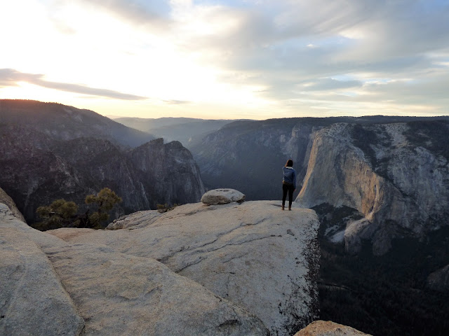
Just beyond the fissures, the world ends...the cliff edge is the beginning of a sheer 3,000 foot drop to the valley floor below. The perspective is both stunning and dizzying. It's hard to believe, but the viewpoint makes El Capitan look almost...small. It's scattered in with so many other steep cliffs.
The fast-setting sun illuminated the cliff of El Capitan and the scar of the September rockfall from the cliff at Horsetail Fall. The first view in the picture above is not actually Taft Point. The point is on the upper left. I would have to head up there to get the entire view.

There are four stunning viewpoints within a short walk of Glacier Point Road. Washburn Point, seen in the last post, emphasizes the wilderness lands upstream of Yosemite Valley (and a side view of Half Dome). Glacier Point provides a look straight down into the upper end of the valley, extending from Half Dome and Tenaya Creek Canyon to the area around Yosemite Falls. Sentinel Dome provides a 360 degree panorama of the entire region, but without the dizzying look straight down sheer cliffs. It is accessed from the same trailhead as Taft Point.


Taft Point picks up the view of the valley floor at Yosemite Falls and provides a panorama of the western parts of the Yosemite Valley, taking in the Three Brothers, El Capitan, and the Cathedral Rocks which soar above Bridalveil Falls (which are hidden on the far side). The sweeping view also takes in the western slope of the Sierra Nevada, leading down to the Mother Lode foothills and the Great Valley beyond.
Although the rockfall at Horsetail Falls in September has garnered all the news these last few weeks, the view from Taft Point takes in a perspective on the largest historic slide in the valley, which happened in 1987. An estimated 600,000 cubic meters of rock came down the cliff of Middle Brother (on the right side of the picture above). Luckily, no one was hurt as the Park Service had shut down the road when loud sounds of fracturing rock were reported coming from the cliffs above. The September rockfall, in contrast, was a bit over 10,000 cubic meters.

The cliff of El Capitan and the sheer cliffs of the Cathedral Rocks form a constriction in the western part of Yosemite Valley. Sometimes called the "Gateway", the rocks stand out because they are relatively unjointed, and thus were more resistant to the cutting and quarrying action of the glacial ice. The barrier even extends underground. Beneath the cliffs, the sediments are only about 300 feet deep. Farther up the valley, the sediments are around 2,000 feet deep. The glaciers at times had to flow up and over the sill of granite.
Taft Point is an amazing place. If you have a fear of heights, this will be a good place to either cure it forever, or amplify the condition to the point that you will be a whimpering mass of a nervous wreck. I don't mind looking over the edges of cliffs myself, although it will sometimes be on my belly. One never knows when one might have a fainting spell, after all. But I cannot watch others standing on cliff edges, especially if they are my students. I tell them to do their antics on their own time.

The sun hit the horizon and the sky exploded into flaming orange and pink. I quickly headed up the trail and back to the car so Mrs. Geotripper and I could have a nice dinner back down on the valley floor. It didn't matter that it was dark. The moon was up and we could still see the cliffs above, including a constellation of lights from at least fourteen climbing parties on El Capitan.

Sunday, December 6, 2015

I've Been Under, Over, and On a Volcano. Now Let's Go Into a Volcano


Being on a volcano isn't too bad,at least if it isn't erupting. In Hawaii, I've even enjoyed being on an erupting volcano. "On" isn't too hard as a rule. You just drive or walk on it. Being over a volcano takes a little aerial technology, but flying to Seattle on a clear day does the trick. I've occasionally posted aerial shots of the Cascades volcanoes.
Getting under a volcano is a bit trickier. One needs to find a place where the magma chambers feeding a volcano have cooled and solidified, and then wait a few tens of millions of years while the crust rises and is stripped away by erosion. The exposed rocks would include granite, granodiorite, tonalite, and diorite. There are some very nice places to see such rocks, especially in my backyard, at Yosemite, Sequoia, and Kings Canyon National Parks in the Sierra Nevada. Needless to say, I've written just a little bit about these places...
Getting into a volcano is pretty much like getting underneath one. It takes less time, since only thousands of feet of erosion are needed, instead of miles. The trick is finding an accessible deeply eroded volcano. One of the most scenic of all eroded volcanoes has to be the half volcano of Pinnacles National Park in California's Coast Ranges. I don't mean "half" in the sense of half eroded away. Half of the volcano is missing for other reasons (read on...).

We took our last official field trip of the semester a few weeks back, and our destination was Pinnacles, being our nation's national park, and one of the most scenic and geologically interesting parts of the Coast Ranges (although there are many things that are geologically interesting about the Coast Ranges). Of course, as is my wont, I lectured and talked about the geology, but no lecture can ever compete with field experience. I sent the students up the trails to see the geology up close.

I headed up the Condor Gulch Trail. It connects after 1.7 miles with the High Peaks Trail, which is one of the finest short hikes in North America. My heart was there, but not the time. I made for the Condor Gulch Overlook, and continued another half mile to gain some wonderful views of the surrounding territory.
The volcano at Pinnacles National Park was a composite cone with at least five vents or domes composed of rhyolite lava and breccias. I imagine the closest analog to the volcano in California today wold be Mammoth Mountain in the eastern Sierra Nevada, although Pinnacles was situated much closer to the ocean, and may have been partly under water. Most of the rocks exposed along the trail began as mudflows on the flanks of the volcano, the summit of which was located a couple of miles south of the trail I was following.
From the Condor Gulch Overlook, one can look into a series of potholes where the intermittent stream flows over the volcanic bedrock. Boulders in the swirling currents have eroded the holes, which may hold water for weeks or months after major storms. The water is can be critical for wildlife in the area.

The Pinnacles volcano erupted near the newly forming San Andreas fault system, and the volcano was actually split in half by the fault motions. One part of it remained in southern California where the exposures are called the Neenach Volcanics. They can be seen in the Lancaster area quite close to the Antelope Valley Poppy Preserve. The rocks on the other side of the fault were carried north some 195 miles (314 kilometers) over 23 million years. It wasn't wasn't fast...maybe 2 inches per year, but the manner in which it happened was pretty violent. Every century or so there would be an earthquake in the range of magnitude 7.5-8.0 that moved the fault 10-20 feet all at once. The process continues today, with the San Francisco earthquake of 1906, the Fort Tejon earthquake of 1857, and the Loma Prieta earthquake of 1989. Enough stress is built up on various segments of the faults to produce large and damaging earthquakes, events that California needs to be prepared for.

From the ridgetop, the landscape appears gentle and serene. The thick brush and Gray Pines hide evidence of a violent past: volcanic eruptions, earthquakes, mudflows, and landslides. Today, the park is a delightful place to explore, with 30 miles of trails. I certainly enjoyed the three miles I traveled the other day.
If you are having trouble visualizing what 195 miles looks like, check out the fault map below that shows the location of the San Andreas, the Pinnacles volcano, and the Neenach volcanics.

Tuesday, November 11, 2014

If These Cliffs Could Talk: A Sentinel People Sometimes Miss in Yosemite

If you saw this picture out of context, perhaps in the opening frames of an adventure movie, you might think of this cliff as being an otherworldly precipice full of allure and mystery. Maybe dragons perch on its summit, maybe buried treasure lies in a cave at its base. It's an incredible rock tower.

To back up and look at this cloud filled world from a distance takes away none of the mystery. Here is a spectacularly deep gorge with dark forested slopes and vertical rock cliffs. What kind of place is this? Who's been keeping it such a secret? Shouldn't it be a national park or something?

Well, actually it is, and upwards of four million people look at this cliff tower every year. They just don't quite see it as it gets lost in the multitudes of other more iconic cliffs like Half Dome, El Capitan, and Cathedral Rocks. Half Dome would be in the picture above were it not for the clouds.

We are looking at Sentinel Rock, and it is the hard-to-see tower in the dead center of the picture below. Can you see how easy it is to lose it in the grandeur of the cliffs that surround it on all sides? I was taking advantage of the cloud cover to get a photo from Tunnel View that highlights the cliff.
How could you miss it? It's in the dead center of the photograph! (May 2014)
Sentinel Rock is composed of the Sentinel Granodiorite, which was intruded about 95 million years ago, making it one of the younger intrusive rocks exposed in Yosemite Valley.It is a gray colored rock composed mostly of plagioclase feldspar with lesser amounts of orthoclase feldspar and quartz. The black specks in the rock are biotite mica and hornblende.
As pointed out in the previous posts of this short series on the cliffs of Yosemite Valley, joints are vertical or nearly vertical fractures that can result from stresses on the rock at shallow depths in the crust. Rocks like the Half Dome granodiorite and El Capitan granite are sparsely jointed and stand as bold cliffs that stand out from the valley walls. The Sentinel granodiorite is somewhat more jointed, so it stands more as a tower than a large cliff. It is surrounded by spires and fissures, including the Taft Fissures that can be accessed by trail above the rim of the valley.

Sentinel Rock soars 3,000 feet above the valley floor with an elevation of 7,038 ft (2,165 m). It is a popular climbing challenge. No trails reach the summit, but the Four-Mile Trail to Glacier Point winds across the slopes below. There is a separate peak called Sentinel Dome behind the rim above Sentinel Rock that is a popular hiking destination.
Sentinel stands out in the boldest relief when viewed from Cook Meadow where most everyone stares at Yosemite Falls directly across the canyon. If you are ever lucky enough to visit Yosemite and are standing in awe below the falls, don't forget to look behind you!
There are several other pullouts on the valley loop road that offer good viewpoints, especially with the Merced River in the foreground. If you've been up the Four-Mile Trail or the trail to Yosemite Falls, I'd love to see some of your pictures! I hate to say it, but I've been halfway up the falls trail, snapping pictures right and left, but I didn't get a single shot of Sentinel. Half Dome, yes. Yosemite Falls, upper, middle and lower, yes, selfies, yes, but no Sentinel. It hides in plain sight.
A wonderful rock!

Thursday, November 6, 2014

If These Cliffs Could Talk: The Cathedral Rocks vs.the Cathedral Spires


Cathedral Rocks and Bridalveil Fall from the Gateway View (April 2014)
Yosemite Valley has such a richness of sheer and spectacular cliffs that I imagine any one of them would rate being a national park or monument of its own in any other setting. Looking at the most famous cliffs, one can be distracted from recognizing the awesomeness of cliffs that loom behind. . We began yesterday with a look at Leaning Tower and Bridalveil Fall at the west end of Yosemite Valley on the south side of the canyon. These rocks are familiar because they are often the first to be encountered when one arrives at Yosemite for the first time. Bridalveil Fall is visible from the Tunnel View, and is the first major parking area when starting the valley loop road.

Today's cliffs are the Cathedral Rocks and Cathedral Spires. The Cathedral Rocks are as familiar as Bridalveil, as they provide the backdrop to the falls (above). There are three prominent triangular peaks. From the Tunnel View or from the Valley View turnout they are spectacular, but are not vertical cliffs. To get that perspective, you'll have to walk or drive east of Bridalveil Falls. Things get very steep in a hurry.
The Cathedral Spires and the Merced River, November 2014
One of the first things to note is that the Cathedral Rocks and Cathedral Spires are two different features. The spires are a pair of prominent towers of rock tucked into a recess just east of the Cathedral Rocks. The imposing towers are composed of the very tough El Capitan granite, but are separated by exposures of the highly jointed Diorite of the Rockslides, a rock that is subject to mass wasting (rock falls and slides).

Spires like these are usually found along the rim of Yosemite Valley, high above the valley floor, as they are easy targets for removal by glacial ice. The later ice ages, the Tahoe and Tioga stages, did not come close to filling the valley at this locale, and thus were not able to strip away the narrow fissured towers.
The Cathedral Spires, November 2014
The Cathedral Rocks, when viewed from other angles in Yosemite Valley, are simply stunning. I was lucky to show up in Yosemite in January 2011 on the heels of an intense snowstorm. Snow was literally clinging to the cliffs in the late afternoon, and the winds had died down, leaving a mirror-like lake in one of the meadows, with a cold mist rising. It's one of my favorite pictures (below).
Cathedral Rocks in January 2011, from near Leidig Meadow
Another perspective is provided by the trail that winds east from Bridalveil Fall. It follows the base of the sheer cliff, an angle hard to capture in a photograph.
Does it look to you like the dead stump in the foreground is holding back a really big boulder?

The cliffs are visible from several other meadows, although people are sometimes distracted by the views of El Capitan or Yosemite Falls. The picture below is from Cook Meadow, which is better known for the spectacular view of Yosemite Falls and the Three Brothers.
Cathedral Rocks from Cook Meadow

Finally, one should never forget that there are places where you can look down into Yosemite Valley. A drive to Glacier Point is never a wasted day, but one should set aside some time to take a couple of short trails to the rim, including Sentinel Dome, and Taft Point. Taft Point in particular offers a wonderful view of the Cathedral Rocks from above. It is from here that one gains a real appreciation for how tough the El Capitan granite truly is. The rocks project well into the valley, forming a narrow passageway between Cathedral Rocks and El Capitan. The valley is barely 2,500 feet across at this point. El Capitan rises 3,000 feet on the one side, while the Cathedral Rocks loom 2,600 feet above. At this point the canyon is deeper than it is wide!