Showing posts with label Neenach Volcanics. Show all posts

Tuesday, November 28, 2017

It Seems That Half the Volcano is Missing: Travels at Pinnacles National Park

Sixty or seventy years ago, the San Andreas fault didn't exist. Well, it existed, but not in the way it exists for those of us in California today.  It had been named only in 1895 after a valley and reservoir on the San Francisco Peninsula by Professor Andrew Lawson, and it was only after the disaster of 1906 that it was recognized to be a feature that extended for hundreds of miles into southern California. Although the earthquake produced clearly defined lateral motion amounting to as much as 20 feet along a fracture running for 200 miles, it was still considered to be a fault with primarily vertical motion. The reason? Some meteorologist named Alfred Wegener was stirring up controversy in the geological world by claiming that continents drifted across the face of the planet. Geologists knew this was impossible, and therefore the idea of large-scale horizontal motion along fault zones was highly unlikely.
Looking north towards the High Peaks of Pinnacles
Still, geologists kept finding stubborn little problems with the assumption of vertical motion. Levi Noble suggested in 1927 that the fault in southern California had shifted some Cenozoic sediments around 26 miles. The idea was controversial. Robert Wallace produced even more debate, suggesting in his Ph.D. thesis that a portion of the fault in the Mojave Desert had been shifted 75 miles sideways.
View from the High Peaks Trail at Pinnacles National Park
The real shocker came just a few years later in 1953 when Thomas Dibblee Jr. and Mason Hill published an explosive paper in the Geological Society of America Bulletin. Thomas Dibblee Jr. was recognized for his amazing ability to map large swaths of central and southern California (see the map below). Mason Hill had developed a reputation as a finder of oil using geological methods (strangely, prior to the 1920s oil companies had little interest in employing geologists; that changed quickly). They worked together for a number of years for the company that became ARCO, mapping out structures in the rocks near the San Andreas fault in Central California. In time they began to recognize that there were similarities between rocks on opposite sides of the fault, but offset by dozens, even hundreds of miles. Their paper documented the amount of offset (up to 320 miles!), and preceded other discoveries at the time that suggested that "continental drift" (actually plate tectonics theory) was in fact how the planet was working.
Parts of California mapped by Thomas Dibblee Jr. (from the Thomas Dibblee Foundation)
Although their main conclusions were eventually accepted, their idea was hobbled by the lack of a "piercing point", a geological feature that crossed the San Andreas fault with a sharp boundary that would allow precise measurement of the total offset along the fault. Although their correlations were sound, there was some uncertainty about just how much the fault had moved.
Climbing the High Peaks Trail
Although it was right there on the state geologic map, few people seemed to notice that there was a little dot of volcanic rocks on one side of the San Andreas fault, and another 195 miles north along the fault on the other side of the fault. The rocks were broadly of the same age and general composition, but no one had carefully mapped them, and even more importantly, compared them. It fell to Vince Matthews III in 1976 to do the work. He found striking similarities between the two rocks sequences, the Pinnacles Volcanics, and the Neenach Volcanics (below). A good piercing point had been found! The San Andreas fault had slipped sideways a total distance of 195 miles in 23.5 million years.
From Vince Matthews III documenting the correlation of the Pinnacles and Neenach Volcanics. Source: USGS Professional Paper 1515
And that brings us to the subject of this post, Pinnacles National Park. Established recently, in 2013, it had actually been declared a national monument in 1908 by President Theodore Roosevelt. Of course no one in 1908 knew that the spectacular spires and peaks were only half of a volcano, or that the volcano had been shifted 195 miles from its original location in Southern California. But it was known that the mountains were far different than the "usual" low ridges and valleys of the Coast Ranges. They stood out. (NOTE: I'm sorry for the black font that follows. I don't know how it got there and I don't know how to remove it...)
Into the Bear Gulch Caves (bring a flashlight if you go)
Pinnacles National Park is a fascinating place to visit for many reasons. It was once a stratovolcano (composite cone) composed of andesite, dacite, and rhyolite standing perhaps 8,000 feet above sea level. It had at least five eruptive centers, which would have given it a less symmetrical profile than peaks such as Fujiyama or Mt. Hood. Perhaps a good analog that can be visited today would be the lumpy edifice of Mammoth Mountain, that of the famous ski area in the eastern Sierra Nevada.
At the top of the Bear Gulch Caves, just below the reservoir
The volcanic rocks are fairly resistant to erosion, but are riddled with joints and fractures that allow water (and sometimes ice) to get in and weather the minerals to clay. Mass wasting does much of the rest, causing gigantic boulders to slide, tumble and fall into the adjacent valleys. In some cases the boulders were so thick that they covered the bottom of the canyon, forming some fascinating talus caves. We explored the Bear Gulch Caves during our recent field studies to the park. The CCC built a trail and stairway through the cave, leading to an experience akin to the Fellowship of the Ring exploring the Mines of Moria. There is even a modest underground waterfall. At the end of the caves, one more stairwell climbs the rock wall to the modest Bear Gulch Reservoir, also built by the CCC. 
There are miles of other trails in the park, including the High Peaks Trail that must not be missed as long as your phobia of heights is held in check. It is a marvelous 5 mile loop that provides awesome views. Other trails explore the sycamore woodlands along the streams. There are several visitor centers and a campground. If you pay close attention, you will see California Condors soaring in the skies above.
In case you are wondering, the Neenach Volcanics are not nearly as dramatic as Pinnacles. They are exposed at the edge of the Mojave Desert relatively close to the Antelope Valley Poppy Preserve. I stopped there a few years back and got a couple of pictures and some rock samples. It's kind of neat to pull out the tray of Neenach Volcanics samples during our field trip and do a visual comparison with the Pinnacles rocks. We end up bringing the sundered volcano back together in a small way...


Hill, M.L., and Dibblee, T.W., Jr., 1953, San Andreas, Garlock, and Big Pine faults, California: Geological Society of America Bulletin, v. 64, p. 443–458.

Matthews, V., III, 1976, Correlation of Pinnacles and Neenach volcanic formations and their bearing on San Andreas fault problem: Bulletin of the American Association of Petroleum Geologists, v. 60, no. 12, p. 2128-2141.

Monday, April 10, 2017

From the Archives: The Other California- A Wandering Volcano and a Floral Outburst

I don't expect to be able to visit the Southern California "Superbloom", this year, but I have seen it in the past, and thought you might enjoy some geological perspectives on why the poppies do so well in the western Mojave Desert. I found it an interesting story. I also updated the photos to include higher resolution  and added a few bonus shots. This story appeared April 18, 2010 (that's the late Pleistocene in blog years...)

I can still be astounded....

There are lots of things I haven't seen and done in my life, but I can imagine what it is going to be like to see a rhyolitic volcano erupting at close quarters, or to feel a magnitude 8 quake (6.9 is my biggest so far). But sometimes things happen that just leave me breathless, if only from the unexpectedness of it all. That's what happened to me today.

I had always heard about the Antelope Valley California Poppy State Reserve, but had never seen it, especially in the late winter or early spring when the blooms are at their peak. We were taking an alternate route home, generally following the San Andreas fault from Cajon Pass to Grapevine Summit on Interstate 5. The desert was mostly dry and barren for much of the route, but as we passed Palmdale and Lancaster, I looked west and saw something I had never seen before: orange hills. Fluorescent orange hills. As we drew closer, it was clear that the California Poppies were at their golden best.

After expending several hours using vast amounts of digital space on my camera, I started to ponder why the flowers were here, and not elsewhere across the Mojave Desert, at least not in such dominating numbers. I first considered the slightly higher elevation, the local rocks and sediment, soil conditions and drainage, but I started to realize there was another dynamic going on...the flowers are a natural phenomena, but a natural phenomena with a very human influence. About seven miles west of the Poppy preserve there is another state park: Arthur B. Ripley Desert Woodland State Park. The park preserves 580 acres of what turns out to be the native land cover of the Mojave Desert west of Lancaster and Palmdale: juniper woodland and Joshua Trees.

A century ago, this high end of the desert was cleared of Joshua Trees and Juniper, usually by chaining (dragging a huge chain between tractors that knocked down whole forests) or fires in order to put in thousands of acres of alfalfa fields and other crops. Large areas were reserved for sheep and cattle grazing as well. The natural plant cover was long gone. Much later, some of the abandoned fields started to recover, and the showy wildflowers represent some of the pioneer species (I've noticed for years that the best wildflower shows in any forested areas occur after fires: Yellowstone, Yosemite, and many other areas). Without any nearby natural vegetation, there is no way for the native Joshua Trees and other large trees and shrubs to recolonize the valley floor; they don't have any method to spread their seeds widely (Joshua Trees were once spread in giant ground sloth poop...). Despite their incredible beauty, the wildflower displays are a monument to our extensive alteration of the environment that once existed here.


Just the same, the flowers were one of the most intense displays of color I've ever seen. Lest you think that I had discovered some isolated and unknown Eden, well, a look at the photo below should dissuade you from thinking that these poppies are a well-kept secret. It was actually impossible to get to the park visitor center due to the traffic. Just the same, there was plenty of parking both east and west of the park, and the poppies and other flowers were every bit as abundant. We had no trouble finding some wonderfully quiet corners to contemplate the beauty (addendum: trampling of the flower meadows is a real concern, especially this year. If you visit, stay on the roads and trails).


As to the wandering volcano of the title? Just west of the preserve, some unusual rock outcrops can be seen near the junction of Lancaster road and Highway 138 at Neenach. These rocks, the Neenach Volcanics, are about 23.5 million years old, and lie adjacent to the San Andreas fault. The volcano is only half here; the remainder sits on the other side of the fault, 195 miles to the northwest, at Pinnacles National Monument, which I have discussed earlier, here and here. For several reasons, the Neenach Volcanics have not been exposed in the spectacular manner of the rocks at Pinnacles, but the story they tell is just as compelling.

So there, I found a geologic connection that allowed me to show you some flower pictures. You'll probably see a few more gratuitous flower pictures in coming posts. I took around a hundred, and I have to show them to somebody...

For those who are new to Geotripper, the "Other California" is my long-running web series on the fascinating geological places in my fine state that don't usually show up on the postcards (although I've been known to break my own rules every so often; California's poppies are on postcards all the time).

Sunday, December 6, 2015

I've Been Under, Over, and On a Volcano. Now Let's Go Into a Volcano


Being on a volcano isn't too bad,at least if it isn't erupting. In Hawaii, I've even enjoyed being on an erupting volcano. "On" isn't too hard as a rule. You just drive or walk on it. Being over a volcano takes a little aerial technology, but flying to Seattle on a clear day does the trick. I've occasionally posted aerial shots of the Cascades volcanoes.
Getting under a volcano is a bit trickier. One needs to find a place where the magma chambers feeding a volcano have cooled and solidified, and then wait a few tens of millions of years while the crust rises and is stripped away by erosion. The exposed rocks would include granite, granodiorite, tonalite, and diorite. There are some very nice places to see such rocks, especially in my backyard, at Yosemite, Sequoia, and Kings Canyon National Parks in the Sierra Nevada. Needless to say, I've written just a little bit about these places...
Getting into a volcano is pretty much like getting underneath one. It takes less time, since only thousands of feet of erosion are needed, instead of miles. The trick is finding an accessible deeply eroded volcano. One of the most scenic of all eroded volcanoes has to be the half volcano of Pinnacles National Park in California's Coast Ranges. I don't mean "half" in the sense of half eroded away. Half of the volcano is missing for other reasons (read on...).

We took our last official field trip of the semester a few weeks back, and our destination was Pinnacles, being our nation's national park, and one of the most scenic and geologically interesting parts of the Coast Ranges (although there are many things that are geologically interesting about the Coast Ranges). Of course, as is my wont, I lectured and talked about the geology, but no lecture can ever compete with field experience. I sent the students up the trails to see the geology up close.

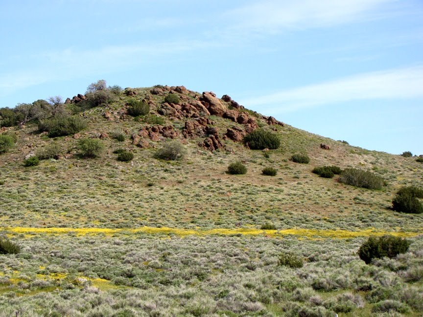
I headed up the Condor Gulch Trail. It connects after 1.7 miles with the High Peaks Trail, which is one of the finest short hikes in North America. My heart was there, but not the time. I made for the Condor Gulch Overlook, and continued another half mile to gain some wonderful views of the surrounding territory.
The volcano at Pinnacles National Park was a composite cone with at least five vents or domes composed of rhyolite lava and breccias. I imagine the closest analog to the volcano in California today wold be Mammoth Mountain in the eastern Sierra Nevada, although Pinnacles was situated much closer to the ocean, and may have been partly under water. Most of the rocks exposed along the trail began as mudflows on the flanks of the volcano, the summit of which was located a couple of miles south of the trail I was following.
From the Condor Gulch Overlook, one can look into a series of potholes where the intermittent stream flows over the volcanic bedrock. Boulders in the swirling currents have eroded the holes, which may hold water for weeks or months after major storms. The water is can be critical for wildlife in the area.

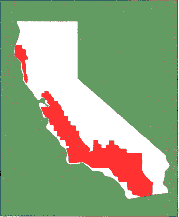
The Pinnacles volcano erupted near the newly forming San Andreas fault system, and the volcano was actually split in half by the fault motions. One part of it remained in southern California where the exposures are called the Neenach Volcanics. They can be seen in the Lancaster area quite close to the Antelope Valley Poppy Preserve. The rocks on the other side of the fault were carried north some 195 miles (314 kilometers) over 23 million years. It wasn't wasn't fast...maybe 2 inches per year, but the manner in which it happened was pretty violent. Every century or so there would be an earthquake in the range of magnitude 7.5-8.0 that moved the fault 10-20 feet all at once. The process continues today, with the San Francisco earthquake of 1906, the Fort Tejon earthquake of 1857, and the Loma Prieta earthquake of 1989. Enough stress is built up on various segments of the faults to produce large and damaging earthquakes, events that California needs to be prepared for.

From the ridgetop, the landscape appears gentle and serene. The thick brush and Gray Pines hide evidence of a violent past: volcanic eruptions, earthquakes, mudflows, and landslides. Today, the park is a delightful place to explore, with 30 miles of trails. I certainly enjoyed the three miles I traveled the other day.
If you are having trouble visualizing what 195 miles looks like, check out the fault map below that shows the location of the San Andreas, the Pinnacles volcano, and the Neenach volcanics.

Wednesday, January 2, 2013

Introducing Pinnacles National PARK!

One of our nation's oldest national monuments is set to become our nation's newest national parks, and I couldn't be happier about it! Assuming the legislation is signed by President Obama, Pinnacles National Park will be one of the most geologically interesting parks in the system for a number of reasons, not the least of which is that it lies on a major plate boundary, and provided critical evidence for understanding the movement of the San Andreas fault. It doesn't hurt that it is also one of the most scenic portions of the central Coast Ranges of California (mind you, Big Sur is beautiful too, but remarkably no part of Big Sur is a national park or monument).
Pinnacles was established in 1908 by Theodore Roosevelt under the auspices of the National Antiquities Act, which was one of the wisest acts of Congress ever. The act allowed presidents to establish monuments without congressional approval, and without it we might never have had Grand Canyon, Zion, Petrified Forest, Death Valley, or Joshua Tree National Parks, because all of them were established as monuments at first, often over local opposition. It often took decades, but Congress would eventually come to its senses and make the monuments into national parks, as it did this week with Pinnacles.
I have been taking geology classes on field studies trips to Pinnacles National Monument now for 24 years, and it has been a significant part of my blog explorations of California (click here for a sampling of some of my descriptions of the region). The geological attraction of the park is the 22 million year old extinct stratovolcano that erupted on top of the San Andreas fault in southern California near Palmdale and Lancaster in the Mojave Desert. Subsequent movement along the fault has carried the Pinnacles half of the volcano 195 miles northwest to its present location in the central Coast Ranges (the other half, called the Neenach volcanics, aren't nearly as scenic).
The ancient volcano has eroded into an intricate maze of spires and deep slot canyons. The High Peaks Trail loop, which traverses the most rugged part of the Pinnacles, is close to the top of my list of favorite hikes in the world (and mind you, that is a list that includes Angels Landing in Zion, Delicate Arch in Arches, the Grand Canyon, and the Burgess Shale in Canada). The slot canyons have in places been completely covered over by gigantic boulders, forming talus caves. One is a quarter mile long, and includes an underground waterfall.
The park has some great wildlife and botanical attractions to complement the wonderful geology. To this day it remains the only place where I've seen a wild bobcat. It is also home to one of the few populations of the California Condor, and they can often be viewed from the visitor center on the east side of the park.
Pinnacles National Monument was enlarged several years ago, and there is a proposal to incorporate ranchlands to the east across the San Andreas fault. This would be an excellent idea if the funding could be found to do it. The park is already an example of a transform boundary, and expansion would add rocks that formed in the Franciscan subduction zone that effected the region during Mesozoic and early Cenozoic time.
On a political note, I want to thank Representative Jeff Denham for co-sponsoring the legislation that is allowing the monument to become a park. Denham represents my district, and on most issues (really, all of them) we greatly disagree. But on this, he did good.

Pinnacles National Monument-soon-to-be Park can be accessed by paved roads from the west out of Soledad and King City, and from the east on roads out of Hollister and San Juan Bautista (no roads cross the monument). A campground is available on the east side of the park, and 30 miles of trails are available. The park is a popular technical rock-climbing area. There are only nine days left to comment, but an extensive management plan is being considered at this time. Information can be found by clicking here.

Tuesday, November 20, 2012

Pinnacles National Monument: A Strange Landscape in California's Coast Ranges

It was our last field studies trip of the year. After our explorations of the San Andreas and Calaveras faults in the Hollister region of the Coast Ranges, we headed south on Highway 25 to Pinnacles National Monument. Pinnacles is one of our unheralded gems, a beautiful landscape with an unusual origin.
The rocks are strange looking, and far out of character with the "normal" rocks of the Coast Ranges, which tend to include graywacke sandstone, shale, serpentine, and some occasional expanses of granite and metamorphic rock. The knobby rocks in the photo above are the result of volcanic mudflows and lava flows. The Pinnacles are the eroded remnants of a 23 million year old volcano. The scenery was so unique that President Teddy Roosevelt declared the region a national monument in 1908, just two years after the first monument was established at Devils Tower in Wyoming.
The small Bear Gulch Reservoir was constructed by the CCC during the Great Depression. It is maintained as wildlife habitat today (especially for the amphibians, which have suffered disastrous declines in recent years).
The park preserves the remains of five rhyolitic cones that once may have towered 8,000 feet high. Erosion has attacked the volcanic rocks with a vengeance, widening cracks and fissures to form the pinnacles for which the park is named. The mountain ridges are fairly arid, covered mainly with shrubs and Gray Pines, but deep in the canyons and gorges, pockets of cool moist air and permanent springs allow much more lush vegetation to thrive.
And yes, I realized I was standing next to poison oak (lower left side of the photo above).
No one realized it in 1908, but Pinnacles preserves one of the more exciting bits of geology in the state of California. By 1977, geologists had realized that Pinnacles was only half of the original volcano, and that the other half was on the far side of the San Andreas fault...some 195 miles away in southern California near Lancaster in the Mojave Desert. Down south, the rocks are called the Neenach Volcanics. Such huge lateral offsets provided overwhelming evidence confirming the theory of plate tectonics (the San Andreas fault is a transform-style plate boundary).
Oh, and there are some Pinnacles! I actually didn't have a good perspective on them on the trail I took on Saturday, but here are a couple...
I'll wrap up my exploration next time in the unique caves of Pinnacles National Monument.

Monday, November 29, 2010

My California, A Bipolar State

It didn't take long for Ron Schott and Silver Fox to figure out my little quiz yesterday about some odd similarities and disparities in California geography. The question had to do with an "a is to b as c is to d" equivalence concerning the Pinnacles and Neenach volcanics, and San Luis and Castaic reservoirs. The short answer is: they are on opposite sides of the San Andreas fault, they are separated by 200 miles or so, but they are exactly the same. The volcanics are the same volcano, and the reservoirs hold water from the same river system. The difference is the magnitude of timing: it took the San Andreas fault more than 20 million years to shift the sundered volcano 195 miles apart, but we have made an artificial river that carries water 200 miles south in a matter of days or weeks.
I've talked about the story of the Pinnacles volcano in the past (here, for instance), but in short, a volcano that erupted in the vicinity of Palmdale and Gorman in southern California has been ripped apart, and a portion has been transported north at the stunning pace of 2 inches per year, along with the entire Baja Peninsular and everything else west of the San Andreas (see the map above). In some places the fault creeps (see this post from last week), but in at least three long segments the fault builds up stress which is released in huge earthquakes upwards of magnitude 8. The quakes have recurrence intervals of around 100-150 years, and we have experienced two, or maybe three of these in recorded time (1857, 1906, and possibly 1812). If you've done the math, you understand why seismologists are always going on about being prepared for the BIG ONE(s)...

The California Water Project is an engineering marvel (or monster, depending on your political and environmental leanings). The state is truly bipolar, in political leanings (kind of a coast versus inland bifurcation), population (mostly in the south), and in water availability (mostly in the north). The problem is that all the people down south need water, lots of it, and the local mountains only capture about 15% of what they need. In 1960 California voters passed a massive (for its day) bond issue of $1.5 billion to construct a system of aqueducts, canals and reservoirs to transfer entire rivers to the southland. The peak pumping discharge exceeds 13,000 cubic feet per second, which to me is pretty incredible given that our local river, the Tuolumne, is considered to be in flood stage at just 9,000 cfs. It mostly provides water for agriculture in the south San Joaquin Valley where the land had been sinking for decades from overdrafting the groundwater. The remainder is pumped over the Tehachapi Mountains to provide water for 20 million plus people.

Map courtesy of the Legislative Analyst's Office of California

San Luis Reservoir is the largest offstream reservoir in the country with a storage capacity of more than 2 million acre-feet. 'Offstream' refers to the fact that the watershed it blocks provides little or no water. All of it is provided by the aqueduct.

The California State Water Project has caused problems. Decreased water flow into the Sacramento Delta and San Francisco Bay have caused serious environmental problems, and have affected salmon runs as well as impacting other fish and bird populations. It also has a gaping vulnerability: a moderate earthquake could destroy levees in the Sacramento Delta, and inundate the Tracy pumping station with salt water for months or years depending on how soon winter runoff could flush out the water (check my previous post on this here).

Our state is bipolar. After fossil fuels, water is one of the most contentious of political issues that we face now and in the future. It would help if people stopped a moment sometimes while spraying off the driveway and watering their tropical rainforest plants they use for landscaping to consider how much effort was made to get that water.

Saturday, November 27, 2010

Similarities and Disparities: Odd Thoughts and Connections from the Road

When you are stuck on a 400 mile long highway on a holiday weekend, the mind wanders in strange places. As I drove along, I made kind of an odd connection between a few places I visited in the last week. Can you? The picture above is at Pinnacles National Monument in the central Coast Ranges. The place in the picture below is part of the Neenach Volcanics in the Transverse Ranges of California between Palmdale and Gorman.
The lake in the picture below is San Luis Reservoir near Santa Nella.
The lake in the picture below is Castaic Lake in Southern California (picture from the commons at Wikipedia). It fills a canyon region in the western San Gabriel Mountains near I-5 above the Santa Clarita Valley.OK, so here is my observation: Picture #1 is to picture #2 as picture #3 is to picture #4, but on a different scale of magnitude (magnitude of what? Not stated here!). Any ideas?