Showing posts with label Ferguson Slide. Show all posts

Monday, March 14, 2022

The Merced River of California: A Place for Wildflowers and Landslides (and Yosemite Valley)

The Merced River is one of California's extraordinary waterways. First and foremost, it is the river that carved Yosemite Valley, which is one of the world's most spectacular valleys. You may be forgiven for thinking that glaciers carved Yosemite Valley, and they certainly had an important role, but it was learned years ago that the heavy-duty work of carving the 3,000-foot-deep gorge was done before the ice ages ever arrived 2 million years ago. The glaciers certainly modified the shape of the valley, but the depth was first achieved by water flowing over stone.

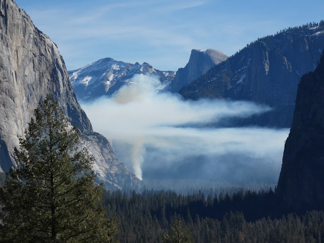
We spent a couple of days in the valley at a time when the crowds are few, the snow is in retreat, but the green of spring is still some weeks away. It was neither winter nor spring, but the waterfalls were full and the birds were becoming more active, and we had a marvelous time. This morning brought a sight we had never seen in dozens of previous visits though: the beginning of a controlled burn. 

The native Americans who first lived and hunted in the valley knew the value of fire. They would regularly set fires to the forest and meadows to clear out undergrowth and maintain the extensive meadows on the valley floor. When the park was established in 1890, fire became the enemy and any hint of a fire was quickly put out. As a consequence the meadows shrank from the original 750 acres to less than 100 today. The forest became choked with young trees, and fuel built up on the forest floor. It was a major disaster-in-waiting. In recent years, the park management has sought to return the valley floor to something resembling the environment that existed prior to European colonization. Some of the activity has involved some controversial logging operations, and the controlled burns can interfere with the experience of visitors, but the eventual changes will be a vast improvement over present conditions.
One of our real motivations for the trip actually involved a different part of the Merced River, the deep canyon downstream of Yosemite Valley. The Merced River canyon downstream of the lowest extent of the glaciers is a different place entirely. The vertical walls of glacially-shaped granite give way to a V-shaped river valley covered by vegetation that often obscures an extensive belt of metamorphic rocks that are hundreds of millions years older than the granite intrusions.
While not as "spectacular" as Yosemite Valley, the canyon is not without scenic wonders. Indeed, for a few weeks in the spring the walls of the canyon can explode into a color palette that puts the gray granite cliffs of Yosemite Valley to shame. Wildflowers like golden poppy, lupine, and fiddleneck and many others can cover the slopes from the river to the canyon rim.
The climax (if it comes; it's been a dry year) lies a few weeks in the future. But here and there, the slopes provided a hint of what is to come.
The redbuds are just getting started with their not-red buds. More of a pink/purple shade if you ask me.
The slopes of the gorge are also an environment adapted to fire. In the Mediterranean climate the winters are cool and wet, and the summers are very hot and dry. Fires have always swept through the gorge, but those of recent years have been particularly intense due to the extended droughts and higher temperatures due to global warming.
Ultimately fires are a necessary part of the environment, but they can seem particularly tragic in the short-term, especially when people are killed or developments destroyed. The wildflowers play an important role in the recovery of the slopes, as they are pioneer species that help rebuild nutrients in the soils that can assist in the return of the shrublands and forest. The seed may lie in the soil for years before conditions are right for germination, and then the barren slopes come alive with color.
The Golden Poppy is a particularly visible part of the wildflower population. It is California's state flower, and it was a great choice because it thrives in many if not most of California's diverse ecosystems. They're common in the Coast Ranges, the Great Valley, the Sierra Nevada foothills, the volcanic landscapes of the Cascades and Modoc Plateau, the mountains of southern California, and in the Mojave Desert (the Antelope Valley Poppy Reserve is spectacular right now, from what I am hearing). They can also grow on California's strange serpentine soils that most plants cannot tolerate.
A final sight were looking for was the Ferguson Slide. The slope at this particular turn in the river was always unstable, but in 2006 the entire slope slide downwards and covered the highway with tens of thousands of cubic yards of boulders. Far more debris remains on the slopes above, and for a time there were fears that a truly massive slide could block the river and form a natural dam with a lake several miles long. A number of "fixes" were considered, and in the meantime "temporary" bridges were built to provide one-way access on the busy highway. Temporary in the sense that they have been there for fifteen years and counting.
In the end they have decided to build an "avalanche shed", but for rocks instead of snow. The cost is in excess of $180 million (which at the time was about the entire budget for Yosemite National Park). Nature doesn't take kindly to attempts at altering the physics of the slope, and some of the first attempts at stabilizing the upper slopes were laughably sloughed off. There was an earlier coating of the fencing material that was destroyed soon after application. They spent several years carting off nearly 150,000 cubic yards of metamorphic rock and have again tried to fence in the slope. It will be interesting to see what happens when the construction of the shed actually begins.
The photo above is the most comprehensive picture I've been able to capture. I made sure to be last in line when the traffic light changed and allowed the line of cars to follow the one-lane road. I lingered a few seconds to get the shot, and hurried along to make sure I didn't run into oncoming traffic on the narrow bridge. 

There are many more stories to tell of the Merced River downstream, where it flows through the Mother Lode, the places where it lies trapped in the waters of Lake McClure and Lake McSwain, the dredge pits at Merced Falls, and the slow journey across the floor of the Great Valley where it ends in the San Joaquin River. Those will come another day!

Saturday, April 30, 2016

Rock Will Not Be Contained: Problems at the Ferguson Slide near Yosemite

The Ferguson Slide today, April 30, 2016

I thought of an Ian Malcom quote from Jurassic Park (1983) today:  "If there is one thing the history of evolution has taught us it's that life will not be contained. Life breaks free, it expands to new territories and crashes through barriers, painfully, maybe even dangerously, but, uh... well, there it is."

We were driving past the Ferguson Slide on the Merced River near Yosemite Valley, a huge slump that let loose in 2006, covering Highway 140, and forcing engineers to "temporarily" put the highway on the other side of the river. Try replacing the word "evolution" with the word "geology", and the word "life" with the word "rock", and see if this is appropriate: If there is one thing the history of geology has taught us it's that rock will not be contained. Rock breaks free, it expands to new territories and crashes through barriers, painfully, maybe even dangerously, but, uh... well, there it is.
The Ferguson Slide in November 2016. Source: http://geotripper.blogspot.com/2015/05/work-on-yosemites-ferguson-slide.html

The engineers have been intending to reopen the section of Highway 140 by constructing an avalanche shed. They began work last year by removing a huge amount of rock, and then covering the remaining slide with containment netting. Unfortunately, El Nino made its influence felt, as rainfall this year was more than average. It didn't result in disastrous flooding, but apparently excess water contributed to the failure of the slide in two separate events in November and December. The new slides destroyed half of the containment netting (yes, I'm a bit late with this news, but I haven't been up there a lot until these last few weeks). Engineers are reassessing their options, and work has stopped for the moment.


Saturday, October 17, 2015

A Series of Nearly Unfortunate Events: Fall in Yosemite National Park

Oh jeez, that's not something one likes to see on a field trip...
How many horror movies begin with people ignoring the warning signs, both literally and metaphorically? The doomed characters doggedly soldier on, minor disasters mount, and then major disasters. Today felt a little like that. At our second stop, two CHP units took up positions on both sides of the bus. Uh-oh...

It turned out they were there for the cow which had escaped the nearby pasture. We helped herd the wayward bovine back inside the enclosure.
We passed the continuing effort to contain the huge Ferguson Slide, which collapsed into the Merced River and across Highway 140 nearly ten years ago. It's been completely covered with boulder containment nets, and they are apparently ready to start work on the rock shed that will allow future rocks to roll over the road and into the river.
And then the first of the menacing signs. The rain had started falling, a true blessing in the drought, but why during our field trip? Because it was maybe a metaphorical sign, of course! Don't go on!
But the next sign said not to stop! What were we to do? 
There were fires burning next to the road, and after all the horrific wildfires of last summer, one could hardly resist the urge to call and report the fire. But the signs said not to report! What were they trying to hide?
Sorry for the blur. We couldn't stop!
The actual reason for the fire of course was to try to bring the valley floor back into some kind of reasonable ecological balance. Fires had been suppressed on the valley floor starting when the park was established, but this turned out to be a bad idea. So many trees grew that the forest was too thick and full of fuel that a wildfire could have destroyed all the trees, not just some of them. By burning the forest when conditions are safe, the troublesome trees can be controlled without destroying the mature trees.

So we pressed onward, farther into the valley through rocks, wind, rain and fire, just daring the elements to interrupt our geological field studies. And then we found incredible things! The storm relented for a few moments at at time and the cliffs and towers of Yosemite began to peek out from behind the clouds.
The fall colors were starting to appear here and there...
The clouds provided an interesting contrast to the forests and cliffs...
And at Yosemite Falls, we saw something precious and rare: flowing water. Two days of rain had rejuvenated the iconic waterfall, which had been dry since early summer. All in all, a challenging day, but also a spectacular day. And no crazed axe murderers!

Saturday, May 2, 2015

Work on Yosemite's Ferguson Slide Continues, and Can Someone Tell Me What These Folks Are Up To?

Ferguson Slide on May 2, 2015
Three weeks ago I passed the Ferguson Slide on the way to Yosemite, and found that work had begun on mitigating and stabilizing the slide so an avalanche shed could be constructed to protect vehicles from rolling boulders. Check out my previous post on the subject for details of the slide and the work being done. I was up there again today, and saw that a lot of progress has been made towards removing debris and coating the slope with boulder containment netting. Compare today's progress (above) with a photo from three weeks ago (below).
Ferguson Slide on April 11, 2015

I'm wondering where the debris is going? I didn't think to look today for truck loaders. But something else was going on that made me curious. Usually when helicopters are hovering over construction sites, they are delivering or picking up materials. But this copter was carrying a pair of workers in slings, and they were hovering over the slide.
I'm imagining that they were inspecting the work, but wondered why that wouldn't be done from inside the helicopter. We couldn't stop the bus to watch for longer, so I'm wondering if anyone out there knows what's going on here.
In a completely facetiously mode of thought, I imagined they were joyriding over their handiwork, and were taking turns (the helicopter did go back and forth between the slide and the staging area).

Monday, April 13, 2015

Work Has Begun on the Yosemite Region Ferguson Slide!

I was up in Yosemite last weekend for a class field trip, and was surprised to see a lot of changes at the site of the Ferguson Slide, the huge 2006 slope failure that blocked Highway 140 for months. The road was covered with so much debris that bridges were needed to detour across the river and around the slide. That's been the status quo for most of the last decade. The detour is one way at a time, and a traffic signal slows up traffic into Yosemite Valley. That has been a great inconvenience for businesses in Mariposa that depend on the tourist trade. As I reported a few weeks ago, a final plan had been approved, and work was to begin on fixing things. It didn't take long!
A great many issues had to be considered before work could start. For one, they needed to know if the slide had stabilized, or if it was going to become worse. There were concerns at one point that an avalanche could completely block the Merced River and inundate the small village upstream. There was the river environment to consider. The Merced is a Wild and Scenic River, and major changes have legal ramifications. An extremely rare and endangered creature, the Limestone Salamander (Hydromantes brunus) is found only along the river in this area. Fewer than 2,000 are thought to remain in the world.
The final plan involves the removal of 100,000 cubic feet of debris, and the construction of a 750-foot-long rock shed that will allow future rockfalls to bounce harmlessly over the road and into the river. As I discussed the slide with my students from downstream (we couldn't see it yet), I wondered how they were going to remove debris from below without having more come down on them. The question was answered as we crossed the bridge and had our first look at the mitigation effort. The entire upper portion of the slide was covered by boulder containment nets to catch loose material that might tumble down.
As we drew closer, I couldn't help but notice the gigantic boulder in the middle of the netting, and the dirt road built across the slide, with some kind of equipment at the top. I found myself looking at a career choice I would not have felt comfortable with. I'd love to meet the person who is digging the slope with that spider dozer. That has to be a somewhat nerve-wracking job...
I've seen a slightly more dangerous version of working with rock slides, though. In 2009 we were on the road to Hana on Maui in the Hawaiian Islands. This is what the workers were doing there...

I'll be going up to Yosemite again in a few weeks, and will post reports as I see major changes.

Saturday, March 21, 2015

Work to Begin on the Ferguson Slide on Yosemite Highway 140


The problem with a lot of beautiful national parks in mountain landscapes is that they lie in mountain landscapes. The rugged terrain is subject to landslides, and my favorite nearby park, Yosemite, is no exception. The park has four entrances, but only one can be considered an "all weather" access point, as it follows the Merced River, and does not have to surmount any snow-covered passes. Highway 140 may be the lower route, but it is not without its problems. The Merced Canyon downstream of Yosemite Valley is rugged and steep, some 2,000 feet deep in places. Instead of granitic rock, it carves through the metamorphic rocks of the Mother Lode, including the sometimes unstable slate, phyllite and chert of the Calaveras Complex.

There was a prehistoric slide near Savage's Trading Post. The so-called Ferguson Slide had caused problems in the past, and Caltrans had been looking to stabilize it, but in 2006 it overwhelmed the mitigation efforts and gave way, covering 600 feet of Highway 140 with hundreds of thousands of tons of metamorphic rock. The highway was totally blocked, and there were serious fears that the slide could completely block the river valley and flood the small village upstream.

Local communities, especially Mariposa, were devastated by the Ferguson Slide. Tourism makes up a huge portion of their economy, and with the highway closed, no one was coming through town. The first temporary fix, two quickly built bridges that detoured around the slide, were impassable to buses. Mariposa continued to suffer economic losses, so by 2008 the bridges were realigned. At present there are are delays of up to 15 minutes waiting for traffic to pass the one-way road.

I missed the story at first in the newspaper last week ("newspaper": a form of information transfer that predates the internet), but work has begun on a "permanent" fix on the section of Highway 140 beneath the slide. The first part will involve the removal of more than 100,000 cubic yards of slide debris, followed by the construction of a 750-foot "rock shed" that will channel future debris slides over and across the highway. I've seen snow sheds before on many alpine passes, but this will be only the second rock shed in the country according to Caltrans. The project will cost $133 million and will be completed in fall 2019. The work is not expected to block traffic, as the "temporary" detour will remain open.

I understand that the rock shed approach will be one of the least environmentally intrusive approaches to mitigating the slide (assuming it's done right), but I'm struck by the fact that this one road repair will be only slightly less expensive than the complete renovation of Yosemite's infrastructure following the devastating floods of 1997 ($182 million in 1997 dollars). And it's been nearly twenty years since those renovations, and Congress has never been one to keep up with the care of our national parks. It would be nice if we could take care of our parks as well as we care for the access to those parks.

In any case, this is a good time to be visiting Yosemite via Highway 140. Despite the drought years, the spacing of the few rainstorms we've had has left a lot of greenery along the river corridor. I haven't been up there yet to check, but I'll bet the poppies will be blooming soon, and in force. I'll have a full report about April 11.

Monday, April 14, 2014

The Yosemite No One Sees in Summer...the Merced River Canyon

The drought in California is horrific. It is quite probably the worst drought in centuries, but we received a slight respite in the form of showers and snow during the last part of March and early April. It was a drop in the bucket towards relieving the huge water deficit that has built up in the last few years, but it gave a shot of energy to the seedlings of grasses and wildflowers. They perhaps should have sprouted and grown months ago, and they will be dried out in a few short weeks, but this week, the Sierra Nevada foothills were alive with color.
We were on our way to Yosemite Valley for our geology field studies course last Saturday, and I joked (only in half-jest) that the students had to "earn" the right to learn the geology of Yosemite Valley by first exploring the canyon of the Merced River. We had to prepare ourselves by undertaking a journey through the rocks that predate the granitic rocks that form the walls of the iconic valley. Our route took us through the foothill towns of Snelling and Hornitos, and then we drove up Highway 140 through Mariposa, over Midpines Summit and down into the deep gorge of the Merced River (originally the "Rio de Nuestra Señora de la Merced (River of Our Lady of Mercy)".
Highway 140 winds back and forth through a series of metamorphic terranes, bands of deformed and twisted rocks that traveled across the Pacific Ocean to be mashed into the western edge of the North American Continent. The rocks include slate, schist, marble, phyllite, quartzite and greenstone. These were the ancient rocks (between 600 and 200 million years old) that were intruded by the granitic rocks that eventually were exposed and eroded to form the dramatic cliffs of Yosemite Valley.

The Sierra Nevada is a huge westward tilted block. The slope has allowed the rivers draining the mountain range to carve deep gorges, some deeper than the Grand Canyon (Kings Canyon to the south is about 8,000 feet deep!). The depth of the Merced is more like 2,000 to 3,000 feet deep downstream of Yosemite, and in any other setting in most any other state, this would be enough for the establishment of national parks and the like. Instead, it is "just" the preliminary canyon one must pass through before arriving at Yosemite.

The carving of such deep canyons can have serious geologic consequences for society. The slopes of such canyons are inherently unstable, and mass wasting (landsliding) is a constant hazard. The building of roads and railways adds to the instability by undercutting the already steep slopes. Such is the case with Highway 140. CalTrans has struggled for years to prevent the collapse of a slope near the village of El Portal. In 2006, the slope flicked away the mitigation efforts and collapsed onto 600 feet of highway. The Ferguson Slide, as it is called, closed the highway for months and caused economic hardship for the surrounding communities. Two temporary bridges were constructed to cross the river and circumvent the huge slump. Decisions have yet to be reached regarding the permanent disposition of the highway.
The Ferguson Slide. 600 feet of Highway 140 is buried under the rocks.

As we drove deeper into the Merced River Canyon, the slopes seemed to come alive in orange and gold. The California Poppies have reached the zenith of their blooming cycle. In contrast to my previous gloom and doom post regarding fires, rejuvenation does indeed occur, as many of these slopes have been cleared of brush and chaparral by repeated wildfires, allowing for dense concentrations of wildflowers.

We passed El Portal, and then the Yosemite View Lodge. The name is not totally dishonest; the boundary of the national park does indeed lie a few yards east of the hotel complex, so the view of the granite slope beyond is indeed a view of Yosemite. But it is not yet the iconic valley with Half Dome and El Capitan and Yosemite Falls. It is pretty, though, and the Merced River makes a dramatic dash through the maze of gigantic fallen boulders.
 We arrived at the park entrance station, drove a few more miles, and made our last stop before Yosemite Valley. It was another site of mass wasting, but this time it was a rockfall, and it included granitic rock instead of metamorphic material. The so-called Cookie Slide took place in 1982, and involved around 100,000 cubic yards of material that bounced and fell down the slope onto Highway 140. Once again, the road was blocked for weeks.
 The size of some of the fallen blocks is astonishing. It's hard to see how a block like the one in the picture below held together during the downhill descent.
The rocks are part of an intrusive series called the El Capitan granite, which was intruded about 103 million years ago. A contemporaneous intrusion of dioritic rock lead to some co-mingling of magmas, including the enclave of darker rock in the granite (below).
I've always thought of granite as a particularly beautiful rock. The sparkling mass of quartz (glassy gray color), orthoclase feldspar (white grains), and biotite mica is pleasing to the eye, and tells an odd story: Yellowstone National Park, off in Wyoming, sits on top of a huge magma chamber that may one day explode again (but not tomorrow). In Yosemite, we are sitting within a former magma chamber, under the volcano. As such we are exploring the inner depths of an extensive magma system, brought to light by long periods of uplift and erosion.

In a coming post, we'll see how Yosemite looked on Saturday.

Sunday, April 15, 2012

Three Roads Diverged...but why? Because there's a huge landslide, that's why...

It didn't take Ron Schott long to reveal why three roads diverged in the wood, the subject of yesterday's post on Highway 41 heading into Yosemite National Park. The Ferguson Slide was a problem child for CalTrans and road management crews for many years. The orientation of the river and the dip of the metamorphic rocks on the high ridge conspired with the undercutting effect of roadbuilding to destabilize the slope above the highway (you can see some of the slide activity in this video). The slide permanently covered the highway, and the first temporary bridge did not allow larger vehicles to make the 90 degree turn. Bus tours are the life-blood of the local economy, so the current bridge crosses the river at an angle so longer vehicles can cross safely. I blogged about the slide last year, when I compared the Ferguson slide to a different kind of mass wasting event just inside the park boundaries.

The fix is still temporary, with only a single lane available, so delays are common while cars wait at both ends. A more permanent solution is the subject of extensive studies, which can be reviewed here.
We had to wait at the slide both coming and going home from Yosemite yesterday, so I was able to hop out and photograph a couple of the emerging springtime wildflowers. It was cold and dreary, so most flowers weren't doing much (it had actually snowed the previous day), but a few Indian Paintbrush flowers were visible, and the redbuds were spectacular all up and down the Merced River Canyon. I really want to head back up in the next week or so, and see the poppies and fiddlenecks mantling the high slopes.
But, you ask, how was Yosemite? Spectacular in a different way. Coming up in a future post!

Saturday, April 16, 2011

A Tale of Two Slides: Mass Wasting in the Yosemite Region

First-time visitors to Yosemite Valley who enter the park via Highway 140 from Mariposa are treated with views of a spectacular river canyon along with sights of some interesting ongoing geological processes. One of the odd places along the drive is a stoplight in the middle of the highway near Savage's Trading Post, and a narrow bridge that only allows one-way traffic. After a wait of several minutes, the light changes and traffic crosses the river, only to cross over another narrow bridge a short distance later. What's going on?
The reason becomes clear when one looks across the river. A vast pile of rock covers the old stretch of highway, and the slope above the debris looks not so stable, with big chunks of rock that seem to be taking aim at the river. This is the Ferguson Slide, one of the real headaches for engineers who designed the highway. The present mess dates to 2006, but the slope had been a problem for years. One of my former students who worked for CalTrans kept me posted about the "next thing" they were trying to keep the slope from collapsing onto the highway. It appears that the rock moved as a semi-coherent mass, termed a slump. I think of such slides as mimicking what I do when I hit a recliner at the end of a long day; I slide down into the chair until friction keeps me from moving further. Also, I am usually semi-coherent at that point.


Welcome to the process of mass wasting, the downhill movement of rocks and debris under the influence of gravity. Rivers get a lot of credit for eroding the landscape, but they only cover a very small percentage of the land. Mass wasting processes move material down slopes to where rivers can carry it away. Downcutting rivers steepen slopes, but gravity moves the rocks into the rivers.


The Ferguson Slide is just one example of a problem area along the river. Almost every time I drive the highway, boulders and cobbles from the overlying slopes are littered across the highway. The rocks are ancient volcanic and sedimentary rocks that have been metamorphosed and deformed by compressional forces in the crust related to the subduction zone that once existed in Central California. The rocks are cracked and fissured and are naturally unstable on the steep slopes of the deep canyon. There are few flat places on the valley floor near the river, so roadcuts contribute to the instability of the slopes.

The Ferguson Slide has been active for years, as the scarp at the top of the slide is thousands of years old. There were (and still are) fears that the slope could completely fail, and that a large mass could block the river forming a dam and lake that could inundate developments upstream, and block traffic for years.
A mass wasting event of a different sort is revealed along the highway shortly after entering the national park. In this area the metamorphic rock has been replaced by the more familiar granitic rock the typifies most bedrock exposures in the park. Huge boulders choke the riverbed, boulders far larger than the river could ever move. Glaciers can move such rocks, but glaciers haven't been in this particular area for more than 700,000 years. These rocks have no lichens or stains at all; they broke from the local cliffs much more recently. In 1982, to be exact.
The Cookie Slide covered Highway 140 for months, and broke the main sewer line that served Yosemite Valley (the river wasn't such a nice place to swim for awhile). Granite is a very solid rock, and can form cliffs thousands of feet high (the vast cliffs of Yosemite being an example). But on their way to being exposed at the earth's surface by erosion, the rocks expand from the pressure release, and form cracks and fractures called joints. The joints provide an avenue for water to move through the rock, and also provide a surface for slope failures. The rocks detached from the cliff, broke up into a chaotic mass and tumbled and slid down into the canyon.
Rock falls and slides are a common occurrence in Yosemite National Park and the surrounding region. These are just two examples, but many more can be found with a bit of research and observation. In my travels, I have heard numerous rocks falling, and witnessed two larger rockfalls (which were described in an earlier post here and here).