Showing posts with label Owens Valley. Show all posts

Friday, January 28, 2022

Stuck Between a Volcano and a Hard Place (part 2): Politics and Geology Square Off in a Small Town with a Big Problem

I've been more and more concerned about the public damage being done to the scientific community and larger society as politics has swirled like a tornado around global warming, climate change, and pandemics. Trust is eroding in some quarters, and I only see this leading to worse disasters in the years to come (and really, nearly a million Americans dead is a huge disaster, even though it unfolded slowly over two years; just imagine the impact if those people had died all on one day). This damaged social compact between those who do science and the society at large reminded me that it isn't the first time this kind of issue has affected the public, and a few years ago I wrote about it in a two-part series. Here, with some modifications and updates, is part two.
Twin Lakes, above the town of Mammoth Lakes on the edge of the Long Valley Caldera
So what happened in Mammoth Lakes?

In the last post we talked about the titanic explosion at the Long Valley Caldera 760,000 years and tried to comprehend the scale of an event where 150 cubic miles of ash was blown into the atmosphere, covering much of the country. We then fast-forwarded to the near-present day of Mammoth Lakes in the 1980s. When we left the story, geologists were trying to decide what to do at the ski resort town in the face of astounding earthquake swarms, ground level changes, and increased geothermal activity.

It could probably be called a (tragi)comedy of errors. The USGS volcanologists carefully prepared a report to accompany a NOTICE OF POTENTIAL VOLCANIC HAZARD, the lowest level warning in their guidelines. A reporter from the Los Angeles Times figured out what was going on and published a story about the potential volcanic activity the day before the USGS released their report. The geologists got scooped, in other words, and the story became a runaway train in the national media. The government and emergency services personnel who were supposed to get the report and develop a response plan were blindsided by reporters asking them how it felt to be living in a doomed town.

The carefully worded statement from the USGS noted that "available evidence is insufficient to suggest that a hazardous event is imminent", but it was their description of the hazards that caught the attention of reporters and news hosts: rocks falling out of the sky miles from the eruptive vents, hot ash flows melting thick snowpacks and producing dangerous mudflows, and dangerous gases suffocating people. The very manna of the most desired headline: if it bleeds, it leads.
Hot Creek, a geothermal site in the Long Valley Caldera
By some accounts, the damage to the economy of Mammoth Lakes from the media circus may have been worse than an actual volcanic eruption (though no one died). Tourists stayed away in droves, businesses went belly up, and condo projects were abandoned. The business leaders of the town were livid at the geologists for stirring things up and scaring people (although by my reading, their notices were very conservative and carefully worded). They demanded that the geologists stop their campaign of terror/error, accusing them of bad science or something darker. There were even bomb threats (I had forgotten that detail; see the reference at the end of this post).
Warning sign at Horseshoe Lake, one of the carbon dioxide tree-kill sites on Mammoth Mountain.
The geologists could only respond in disbelief. I feel like I would have said something along the lines of "You are sitting on top of an active body of magma that is a few thousand feet from the surface! It would be irresponsible to keep such a thing secret". The geologists stuck to their guns, and the threat level remained at level one, the lowest level of concern, but concern nonetheless.

The business owners and local politicians went up the chain of command. They appealed to the head of the USGS, and his boss, the Secretary of the Interior, a man named James Watt. They may have communicated with then-president Reagan. As far as I can tell, there was intense political pressure from above, and eventually the director of the USGS unilaterally scrapped the warning system. Poof! It was gone. No discussion. It its place would be an informal warning system of quiet communications between geologists and civic leaders.

If this were a Hollywood movie, what happens next would be preordained. Everyone would come back. The skiers would be happily sliding down the slopes, businesses would be taking in money hand over fist, and suddenly out of nowhere there would be a resounding explosion and all hell would break loose as the caldera gives way to a catastrophic eruption that kills the "evil" business leaders because they had been greedy, and a gritty, yet handsome geologist would lead a beautiful woman and her plucky children to safety. Heck, I could see casting someone like, oh, say, Pierce Brosnan as the geologist and Linda Hamilton as the lady. Maybe call it "Dante's Peak" and move the setting to Idaho for some reason.
Yeah, I'd say that casting choice for the geologist was about right. Either one of them....
But that isn't what happened, of course. The molten magma was almost certainly there, but it cooled and solidified instead of continuing to the surface. The earthquake swarms ebbed, but other swarms have taken place over the years, though most have been tectonic in origin (related to faulting rather than magma). Gases from the magma chamber, especially carbon dioxide, have continued to seep from the ground, killing trees and other vegetation in several areas, including Horseshoe Lake (below). The gases actually killed three people a few years ago.  After some years, the USGS established a volcano observatory that monitors Long Valley, and came up with a new warning system, one with four stages, and specific actions to be taken with each. It's based on colors, just like our former Bush-era terrorism warning system. The town's economy slowly recovered. They started building condos again.
Tree kill area at Horseshoe Lake. Carbon dioxide in the soil suffocates the roots and microorganisms necessary for the tree's survival
Some of the political leaders took a bit of action. One of the main concerns was that an eruption would have destroyed the only paved road out of town. No evacuation would have been possible if the highway was blocked off. A few years after the brouhaha, a road appeared at the upper end of town called the Mammoth Lakes Scenic Route. I have to say that as a geologist that I didn't see a whole lot of scenery as I drove this nice paved highway, but I couldn't help but notice that it was exactly where I would have chosen to put an evacuation route (according to Dick Thompson in Volcano Cowboys, the county supervisors responsible were recalled from office for arranging this bit of road-building; it was like an admission that volcanism was actually possible).
Hot Creek, one of the centers of geothermal activity within the Long Valley Caldera.
In the end, one can only say mistakes were made. Some of those mistakes involved a sort of public relations tone deafness, like releasing a volcano warning on the eve of a holiday weekend, but other mistakes were more nefarious.

There were people willing to deny the possibility of a natural catastrophe in order to protect their profit margins. I see too many parallels in today's political (but not scientific) debates over global warming and climate change, and in the willful denial of the Covid pandemic. The geologists had clear evidence of a volcanic threat and the civic response was to deny the evidence and to attack the reputation of the geologists who were trying to do the right thing. There was a threat to the economy of Mammoth Lakes, but the threat was from a geologic process, not those who discovered and analyzed the volcanic hazard. And threatening the lives of the geologists was criminal. And apparently unpunished.

And the media. What to do about the media? Isn't it amazing how media outlets were willing to blow a story way out of proportion in order to gain ratings? Isn't it nice to know that they don't do that sort of thing anymore? And that the internet (which didn't exist as such in 1983) has turned out to be the very model of accurate and measured analysis of stories like this one, despite the possible instant dissemination of incorrect and potentially dangerous information? I'm so glad we live in an age of logic and reason and respect of scientific research.

Oh, I'm sorry. I briefly stepped into "Opposite-world". I'm back now. Science education and science literacy have never been more important in a world where the internet and media are so irresponsible with their analysis of geological hazards. Every time there is another major earthquake or volcanic eruption, I feel like throwing a shoe through the television screen or computer monitor as the talking heads begin babbling. Instead, I do what I can by throwing words out into the internet trying to offer up a more measured explanation of things. But the mostly ignorant talking heads always seem to win people's attention.

Just imagine the outcome if the geologists at Mammoth Lakes were effectively squelched, no warnings were ever given, and a volcanic eruption had actually occurred. Beyond the devastation, just imagine the scapegoating that would have happened in the aftermath. In Italy such a situation led to prison terms for half a dozen geologists who failed to predict a deadly earthquake (they have since been released).

We can do better than this. Especially those in the news business who are responsible in times of emergency for providing us with reasoned assessments, not sensationalist drabble. When the crisis is over, they can go back to their manic headlines about the personal lives of the stars.

You can read the original post from 2015 here: https://geotripper.blogspot.com/2015/02/the-sierra-beyond-yosemite-politics-and.html

----------------------------
Although aspects of this story of the events at Mammoth Lakes and the Long Valley Caldera are drawn from my memory, I reviewed and confirmed many of the details in the excellent book called "The Volcano Cowboys: the Rocky Evolution of a Dangerous Science" by Dick Thompson (St. Martin's Press, 2002). Check it out, it's a fascinating account of the lives and activities of volcanologists.

Tuesday, December 31, 2019

A Resolution Recommendation: See the World. See as Much of the World as You Can

Grapevine Mountains in Death Valley National Park
When I first began to think about what I wanted to do with my life sometime in my teens, I knew I wanted a job that would take me outdoors for much of the time. When I was in high school, "earth science" or "geology" didn't exist as a course choice. So far as I knew, the "outdoor" major was to be a wildlife biologist, and I started heading that way. But in my first semester at community college, all the classes were full, so I took some course called "earth materials". The next semester I took "earth history", and a field course to the Grand Canyon. And by then I was hooked. I wanted to teach geology (many thanks to my first teachers, Marlin Dickey and Rod Parcel).
Death Valley National Park
My journey to a degree in geology was not an easy one. I did okay in my community college courses, achieving a pretty good GPA, enough to get me into a quality program at Pomona College, where I found the limitations of lazy study skills. I spent three years getting my act together, and another two working for the department before I started the graduate program at the University of Nevada, Reno. Once again I was challenged to the limits of my abilities, especially with a young family to support. But I made it through, holding a crying baby at two in the morning while typing my thesis on a Commodore 64 computer with a daisy wheel printer.
The Trona Pinnacles in the California Desert at Searles Lake
Somehow, I made the cut for a position as a laboratory teaching assistant, and later adjunct faculty at Santa Barbara City College. I worked there for four wonderful years before I was fortunate enough to be chosen as an instructor of geology at Modesto Junior College, where I've been teaching for 31 years and counting.
The 2019 "Super-bloom" in the Mojave Desert of California
Geology provided my one of the greatest gifts of my life. A doctor explores the human body. A computer programmer explores the circuitry of processors. A chemical engineer explores atoms and compounds. But a geologist explores the earth. And I can't imagine a greater privilege. The greater privilege though has been that I have spent a third of a century introducing students to a world outside the confines of their home cities. There is nothing quite like seeing the response of a student seeing the Grand Canyon or Yosemite Valley for the first time in their life.
Mesquite Dunes in Death Valley National Park
Our world, despite our horrible abuses, is a wonderous place, still full of beauty and adventures. Seeing it is a marvelous journey, but having some understanding of how it came to be gives the adventure deeper meaning. Even the plainest of landscapes, say the Central Valley (to us the Great Valley) has a fascinating story, one filled with oceans full of mosasaurs and plesiosaurs, gigantic sharks, and savannas full of mammoths, giant sloths and sabertooth cats.
A Five-spot in Death Valley National Park
Not everyone can travel and explore the planet, for lots and lots of reasons. When digital cameras became widespread, and this thing called the blogosphere appeared some time back in the cyber-early Pleistocene, I finally realized I had another tool with which to share the world. In 2008 I started this blog, with the idea of posting lots of pictures of the beautiful places of the planet. It became a way of introducing the wonders of the planet with people far beyond the confines of my college. I never dreamed I would still be doing it twelve years (and more than 2,100 posts) later. I have always appreciated those who have read and responded over the years.
Yosemite Falls, the 5th or 7th highest waterfall in the world.
In any case, this post is sort of a year-end gift of images from the journeys this year of myself, Mrs. Geotripper, and my wonderful students. If you live in California, a lot of these places are within a day's drive. I took students to Death Valley National Park in February, and Mrs. Geotripper and I made another trip there in March to seek out flowers.
"Mirror" Lake, a seasonal pond on Tenaya Creek in Yosemite Valley. Mt. Washburn in the distance.
Yosemite is close enough to Modesto for a day trip, and I managed to get there on four different occasions this year, mainly in the fall and in the spring. It's a different place with every visit, with new discoveries to be made every time.
The Gateway in Yosemite Valley, with El Capitan on the left and the Cathedral Rocks on the right.
We had the occasion of my grandmother's 100th birthday as a reason to spend a few days camping in the Coast Redwoods of Northern California
Humboldt Redwoods State Park in Northern California
Our summer field studies class gave us the chance to explore the Pacific Northwest and British Columbia. Use the search engine at the top left to check out "Travels in Cascadia" for the detailed stories of the places in the pictures that follow.
Mt. Shasta, the largest (but only second highest) stratovolcano in the lower 48 states.

Cape Flattery, the northwesternmost point of the lower 48 states, near Neah Bay, Washington

The Olympic Mountains from Hurricane Ridge in Olympic National Park

Lupines in Hurricane Ridge in Olympic National Park, Washington

The upper end of Howe Sound, the southernmost glacial fjord on the west coast of North America, British Columbia from near the summit of Stawamus Chief near Squamish

Black Bear in Whistler, British Columbia in Canada

Rainy Lake near North Cascades National Park in Washington

North Cascades National Park in Washington
In September, we carried on an exploration of the eastern Sierra Nevada, traveling over Sonora Pass. We base-camped in Bishop for three days while we explored the High Sierra near Mammoth and June Lake, Mono Lake, and the White Mountains.
Sunrise out of Bishop, California, east of the Sierra Nevada
The White Mountains are an immense range reaching more than 14,000 feet, and containing one of the most unusual forests on the planet: the Bristlecone Pines. The trees live where almost nothing else can thrive, and they live for incredible lengths of time, as much as 5,000 years. From the Bristlecone Forest, one can take in more than a hundred miles of the Sierra Nevada crest, from Mt. Whitney to the Mammoth Lakes area.
The Sierra Nevada crest as seen from the White Mountains
The eastern Sierra Nevada is also a land of volcanism. We explored Devils Postpile, the Long Valley Caldera, the Bishop Tuff, and other features of recent volcanic activity.
Devils Postpile in the central Sierra Nevada
The Sierra Nevada is also one of the finest places in the world to study the effects of the Pleistocene glaciations. The June Lake Loop is an awesome valley that also serves as a gateway to the higher alpine parts of the Sierra.
Silver Lake on the June Lake Loop of the Eastern Sierra Nevada
Mono Lake is an enclosed basin filled by a saline inland sea. It is one of the most important stops on the migratory bird flyway, and the story of its preservation from the schemes of the LA Department of Water and Power is a rare (but still ongoing) environmental victory.
Mono Lake, near Lee Vining, California, east of the Sierra Nevada
Our journey home took us over Tioga Pass and through the high country of Yosemite National Park including Tuolumne Meadows and Tenaya Lake.
Tenaya Lake in Yosemite National Park
Our journeys weren't always on the surface. An October field studies class took us underground at Black Chasm Caves in the Sierra Nevada Mother Lode. There are more than a thousand limestone and marble caverns in California!
Black Chasm Cavern near Jackson, California in the Sierra Nevada Mother Lode
Our last journey of the year took us north to visit family in Oregon and Washington. The weather was not optimal, but I had a brief view of Mt. Rainier from the shores of Lake Washington one morning. The mountain looms over the Pacific Northwest in more than one way. The volcano is close enough to threaten urban areas on the Puget Sound.
Mt. Rainier from Lake Washington, near Seattle.
But in the end, don't forget about the most important place of all: home. There is a bit of nature hanging on anywhere you might live, even in the midst of the biggest cities on Earth. Find that place you can get to without too much trouble and expense, and get to know it well, maybe know it better than anyone else. Learn the birds, the mammals, the bugs, the reptiles. Get to know the rocks and plants. Watch them change over the course of the year. Your life will be richer for it.
The Tuolumne River in Waterford California, my home place
I wish for you the most wonderful of new years and new beginnings, even with the challenges that face us all. Thanks for reading!
The Tuolumne River in Waterford, California.

Friday, August 16, 2019

Geotripping! It Could Be You! Geology of the Eastern Sierra Nevada, September 26-30


The east side of the Sierra Nevada and the adjacent Owen's Valley is one of the most dramatic landscapes on planet Earth. The valley that forms the eastern boundary of the range is two miles deep, twice the depth of the Grand Canyon. The valley contains active faults (responsible for one of California's most powerful earthquakes ever, the 1872 Lone Pine quake), and active volcanoes, ranging from small cinder cones to gigantic calderas that rival those of Yellowstone.
The region is full of fascinating geological features, including Bodie, one of the most well-preserved ghost towns in the American west. There is also the nation's "Dead Sea" which is not really dead at all, preserving the lives of millions of migratory birds. Mono Lake is the epicenter of the LA water wars, an issue that can only become more important as California enters a new and unprecedented climate regime.

Scenery abounds, and tourists and explorers love this region like few others. But how often have people traveled through this region without the awareness of the incredible geology exposed at their feet? Are you one of them? Have you never had the privilege of exploring this incredible landscape? Well, I've got a great opportunity for you...
On September 26-30, the Geology Department at Modesto Junior College will be offering Geology 186, a 2-unit field course on the geology of the eastern Sierra Nevada and the Owen's Valley. We'll leave the college early Thursday afternoon and drive to our expected first night stop at Baker Station, the High Sierra Institute, located in the high country of the Sierra near Sonora Pass. The facility is run by our district for a variety of multidisciplinary classes.
From there we'll cross the Sierra Nevada at Sonora Pass and explore the lands to the east, including Bodie and Mono Lake before arriving at our base camp at Millpond Recreation Area just outside of Bishop in the Owens Valley. We'll spend three days there. We'll check out the Long Valley Caldera, the Volcanic Tableland, Devil's Postpile, Inyo Craters, and Minaret Summit the next day.
The following day we'll head up into the White Mountains across the Owens Valley from the Sierra Nevada, where we'll have a bird's-eye view of some of California's remaining glaciers, and have a look at the oldest trees on the planet. We'll then head south to Lone Pine and Owens Lake.

Our final day we'll head back up through the caldera with a stop at Convict Lake (below) and then make our way home via Tioga Pass and Yosemite National Park.

We'll be camping out, and you'll be your own cook on this trip. We'll travel in school vans. The trip will cost $80 plus the cost of tuition at MJC (about $100 or so). Information can be found at http://hayesg.faculty.mjc.edu/Eastern%20Sierra%20Nevada.html, and the MJC website (to enroll in the class) can be found at https://mjc.edu/. If you live in the Modesto area, we'll have an organizational meeting on Thursday, September 12 at 5:30 PM in the Geology Lab at MJC, Science Community Center 326. If you live outside the area, I can send you the relevant materials.

The Sierra Nevada and Owens Valley is an incredible place to explore. I hope you'll be joining us!

Tuesday, March 6, 2018

The Struggle for Life in a Harsh Desert: The Living Fossils of Fossil Falls

Fossil Falls, the Bureau of Land Management site near Little Lake and south of Owens Valley, is one of the strangest sights in the California Desert. The ironic point of Fossil Falls is that it has neither fossils, nor does it have falls. It is the former path of the glacial ice age Owens River where it drained Owens Lake and spilled over into China Lake Valley. The river was quite vigorous in its time, and carved a fascinatingly complex waterfall complete with giant potholes. But except for the occasional rill formed during rainstorms, the falls have been dry for thousands of years. I've written about the falls at length several times over the years (check out a sampling by clicking here).
But that's not what I wanted to talk about today. I want to talk about something I know practically nothing about (that's my right as a blogger!!). Every time we stop at Fossil Falls and the students are exploring the labyrinth of potholes and drop-offs, I am on my belly staring at a small hole in the lava flow. What could possibly be more interesting than volcanism and glaciers and faulting and the Sierra Nevada?

Well, nothing actually. But after visiting the site for thirty years, some other things can capture my attention...such as a desperate struggle to survive in a horrifically harsh land. In the small crucible of an insignificant pothole, an entire ecosystem has been born, and has only days to grow to adulthood, reproduce, and then die. The players are small arthropod shrimp, and maybe ostracods (seed shrimp).
Arthropods were one of the earliest forms of complex multi-celled life to leave a rich fossil record. Trilobites (the fossils of which we will see in a later post) account for around three-quarters of all of the hard-shelled fossils in rocks from 530 million years ago. The arthropod phylum, which includes the insects, spiders, scorpions, crabs, lobsters and many others, is the most successful lifeform ever to inhabit Earth, both in terms of biomass and in diversity. Arthropods are found in the deepest coldest oceans and in the hottest of rainforests. But one might expect that the desert would defeat them, especially those species which have gills, and thus must live in water to survive. But here at Fossil Falls there are creatures that have adapted to the severe climate. Their secret lies in patience and speed.
Desert Shrimp and Seed Shrimp (or Ostracods?) in close up.
I'm always struck by how these small creatures cling to life in their exceedingly small habitat. They are the extreme example of how life finds a way even in the most difficult of circumstances. No water most of the time? Evolve a way for the species to survive desiccation even if an individual cannot. Water for only a short time? Evolve rapid maturing and reproduction. Long periods of drought, possibly lasting for years? Evolve eggs (or cysts) that can last for years without water. These tiny beings can show a direct line of ancestry to the first arthropods in Paleozoic seas 540 million years ago, but they are very different creatures now.
These little creatures are actually bivalves in the manner of clams, but they are far different. The unfortunate ant provides scale.
I admit to not knowing very much about the species of creatures found in this hole, and an internet search didn't yield very much information. I hope my biologist readers can shed some light on the identities of these creatures. I will gladly add the info to this post. As best I can tell, the larger animals (below) are called Desert Shrimp. The extremely small yellow creatures seem to be either a Seed Shrimp (a Branchiopod), or an Ostracod.
This close up from a previous year shows a shrimp with an egg sac
I got a bit of video showing the ghostly Desert Shrimp and the really hyperactive Seed Shrimp. I guess they all have a lot to do, and not much time to do it in...


.

Sunday, January 14, 2018

A Look Back at Ten Years of Geotripping: You can tell the world is an incredible place when these are the runners up...

This month I've been searching the archives for my favorite posts after ten years of geoblogging. The last two posts involved the ten most incredible places I've ever stood. What's striking is that as wonderful as these places are, I was quickly able to come up with ten (eleven, actually) more sites that weren't any less spectacular. So I posted this on May 19, 2014 as a follow-up to the list of the "best 10 places"...

I've noticed that nearly every movie reviewer puts a list of the runners up at the end of their list of the top ten movies of the year. In that spirit, I'm putting up a set of pictures from the places that almost made my top ten list of the most incredible places I've ever stood. As before, there is no particular order to these personal choices. It's a bit like asking which of your children you love the most...
 Number 20: Horseshoe Bend, Arizona
A few miles downstream of Glen Canyon Dam is a huge entrenched meander along the Colorado River. The deep blue color of the river isn't right; the silt has settled in Lake Powell, but it makes for a memorable color contrast. Learn more about Horseshoe Bend here.
Number 19: Antelope Canyon, Arizona
There are hundreds of spectacular slot canyons scattered across Utah and Arizona, and you don't have to pay to get into them, and the noontime tours can be extremely crowded, as in shoulder to shoulder, but there can be no denying that the long beams of sunlight reaching into the darkness of the labyrinth is a spectacular and unique sight. For more views, check out this link.
Number 18: Observation Point, Zion National Park, Utah
The Angel's Landing Trail in Zion is one of the most spectacular hikes in North America, but I can never forget my adventure of climbing to Observation Point on the other side of the valley and looking hundreds of feet down onto Angel's Landing (the Landing is the peak on the lower right). For more information about Zion, check out this link.
Number 17: Inspiration Point, Bryce Canyon National Park, Utah
Bryce Canyon is one of the most intricately eroded landscapes in the world, and the spires, called hoodoos, look otherworldly. Almost as incredible is to walk among the hoodoos below the rim, so here is a shot of the fir trees growing in the impossible environment of Wall Street Canyon at Bryce.
For more information about Bryce Canyon National Park, click here.

Number 16: Captain Jack's Stronghold, Lava Beds National Monument, California
The northern flanks of Medicine Lake Highland are coated in barren flows of basalt from the gigantic shield volcano. Within the flows are miles and miles of lava tubes, long caves left behind as the lava drained out. This was the setting for the Modoc Indian War of 1872-73, yet another tragic story of destroying the culture and lives of a people, in this case so settlers could have more land to graze cows and grow potatoes. It's a haunting place to stand. For more information, click here.
Number 15: The Big Sur Coast, California
A mountain range rises directly from the sea. That's about the only way to describe the incredible Big Sur Coast of Central California. This is a view of McWay Falls at Julia Pfeiffer-Burns State Park. For more details, check out this post.
Number 14: Muir Woods National Monument, California
I read somewhere that Muir Woods is the most heavily visited national monument in the United States, and I understand why. It's one of the few old growth Redwood Forests left anywhere close to the Bay Area, and it is a wondrous place to wander about. The Redwoods are ancient trees, both in individual age (thousands of years), and in ancestry (back to the age of the dinosaurs). More information about this incredible place can be found here.
Number 13: Pinnacles National Park, California
Around 23 million years ago, a volcanic center of five rhyolitic cones erupted on top of the San Andreas fault. The fault split the volcano, and the two halves are separated by 195 miles. At Pinnacles National Monument, the jointed blocks of lava and lahars have been eroded into towers and spires. The High Peaks Trail is one of my favorite hikes in North America. For more information, check out this link.
Number 12: Owens Valley and the Eastern Sierra Nevada
The most incredible wall of rock that I know is the eastern escarpment of the Sierra Nevada, a two-mile high barrier to storms and human travel. No highways cross a stretch of something close to 200 miles of mountain peaks. The Owens Valley is a deep fault trough that once was going to be one of the most important agricultural regions of California, but because of water diversions by Los Angeles, is now a sagebrush desert. Each canyon hides treasures, and I spent much of my youth exploring as many of them as possible.
Number 11: The Great Western Divide, Sequoia National Park, California
My own personal terra incognita, the Great Western Divide is a high sub-range in the middle of Sequoia National Park across the Kern River from the main Sierra Crest. It's one of the last major parts of California that I haven't set foot on, but I've looked in from the summit of Moro Rock. There are lots of places left to explore in my life...
And another Number 11 (because it's my blog and I make the rules): Mono Lake, California
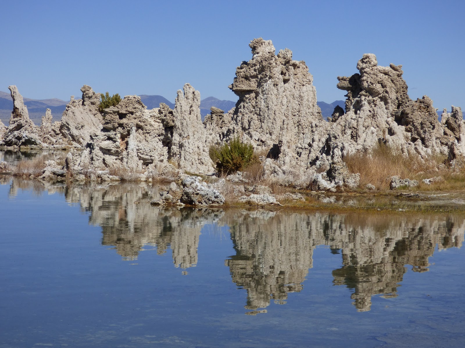
Mono Lake probably belongs on another planet. It's one of the strangest sights in a state filled with strange sights, a lake that is three times as salty as seawater, with a simple ecosystem of basically algae, brine shrimp and brine flies, but the simple combination is a food source for millions upon millions of migratory birds. The edge of the lake is lined with strange tufa towers that formed along freshwater springs.

And that's my highly personal list of the second ten most incredible places I've stood, and it was just as hard to pick out as the first ten! I'd love to hear about more of your favorite places. Put them in the comments, or send me a story that I can post as a guest entry in Geotripper!