Showing posts with label British Columbia. Show all posts

Sunday, November 24, 2019

Travels in Cascadia: Deserts in Canada...and What's with this Lake??

Did you know there is a desert in western Canada, in British Columbia? Well, okay not quite a desert by any standard we have down here in California and the southwestern United States, but it is a distinctly sub-arid region in a part of the continent better known for temperate rainforests. And we Californians tend to think of any place beyond the 49th parallel as an Arctic wasteland of tundra and Polar Bears. So it was a surprise as we left the alpine landscapes of Whistler and Pemberton to enter into sagebrush country and distinctly warmer weather. We were in the Okanagan Valley, on the verge of returning to the United States.
I had heard of an unusual lake to be found in the hills above the Okanagan Valley that would be a pretty handy mystery for our students, and which had a nice connection for our anthropology majors. The only problem was wondering if it would be dry or not.
Dry? Doesn't that defeat the meaning of lake? In most places, of course. But we are talking deserts here, or at least sub-arid landscapes, and yet a landscape that was sculpted by the massive continental glaciers that once covered all of Canada and 30% of the United States. Glaciers scour out all kinds of undrained depressions and blind valleys, so lakes are common. But if they don't have enough precipitation, they will dry up, and that is often the case with the lake we were seeking out that day. And as it turned out, it had been a wet year, and the lake was full of water when we arrived, and so the mystery was not quite as vivid. But there it was...

What are those weird circles in the water??
The lake has a totally different appearance in dry conditions...it's one of the strangest sights I've never seen!
Source: http://www.geologyin.com/2014/12/the-spotted-lake.html. Provenance is not clear...if this is your photo please let me know for proper attribution.

So what the heck is going on here? I will let you know below in case you want to think about it for a minute...
Source:https://tripandtravelblog.com/the-beautiful-spotted-lake-of-canada/ Provenance is not clear, if this is your photo, please let me know for proper attribution

The answer is....I don't particularly know. Well, I know some things. The lake is in an endorheic basin, and as such does not receive enough precipitation to fill the basin it occupies. Thus it dries up rather than flowing through an outlet. The drying concentrates the soluble minerals in the water. The mineral deposits are primarily magnesium sulfates (the mineral epsomite) along with calcium sulfate (gypsum), and sodium sulfate (mirabilite or thenardite). The source of the sulfates are copper minerals in the surrounding hills. Magnesium is provided by local dolomite exposures.

What I admit to not understanding is the formation of the circles and pools. The boundaries of the circles is a dark organic rich mud that develops an efflorescence of white crystals when dry. I wonder if the circles are related to periglacial processes related to frigid conditions in winter, and I would dearly love to be educated about this!

The epsomite has been mined at times a century ago, but the lake is sacred to the local indigenous First Nations people, the Okanagan Syilx. They came into ownership of the lake in 2001, and for the time being it can only be observed from the hills above on the highway, which is reasonable. One can imagine the damage that could be done by unfettered visits of ignorant tourists. The "European" name of the pond is Spotted Lake, but it has been known for centuries by the Syilx as Kliluk Lake.


Thursday, October 24, 2019

Travels in Cascadia: Howe Sound and the Challenge of Living (and Mining) in Vertical Places, Part 2

Howe Sound, the southernmost glacial fjord in western North America, is a fascinating place to explore. We've already looked at the journey by ferry that we used to get there, we've looked at one of the toughest hikes I've ever taken for a bird's eye view of the sound, and a look at some of the engineering required to live in a vertical place.
Today's post is about resource extraction. That mountains have formed here at Howe Sound suggests that huge forces have acted in the interior of the Earth, and the tectonic activity is very often accompanied by mineralization. The rocks here include ancient marine sediments and volcanic rocks that have since been metamorphosed. Hydrothermal activity leached out metallic ores over a wide region and concentrated them in spring deposits on the ocean floor. The ores included iron, zinc, gold, silver, and arsenic, but most of all, they included copper. The ores were discovered in 1888, but it was sixteen years before the ores could be mined and processed because of the remoteness of the region and the difficult terrain. In 1904, the Britannia Mine began production, ultimately becoming the biggest copper mine in the British Empire.
There were extraordinary challenges in developing the mines, not the least of which was the steep terrain, and the lack of access. Landslides and flash floods were constant hazards, and two events were notable: in 1915 a slide demolished one of the mine camps, killing 56 people, and in 1921 a flash flood killed 37 individuals. The mines themselves were dangerous (as they always are) with 98 fatal accidents over the 70 year history of the mine.
The mine was certainly productive, however. During the 70 years the mines operated, ore totals included 650,000 tons of copper, 137,000 tons of zinc, 17,000 tons of lead, 500 tons of cadmium, 188 tons of silver, and 15.6 tons of gold. The gold alone would be worth $750 million at current prices. My rough calculation of the price of the copper the mine produced is $3.4 billion.
The closure of the mine in 1974 was devastating to the local community. Not only were the jobs suddenly gone, but the 130 miles of underground tunnels exposed sulfide minerals to the atmosphere, and acidic waters laced with heavy metals were draining down the hillsides and into the otherwise pristine waters of Howe Sound. The mine was one of the worst point sources of pollution in all of Canada. Mitigation efforts have been ongoing for years, with water being treated to remove the metals, leaving a toxic sludge that is put back into the old mine tunnels.
The community that remained faced the future of many mining boom towns: loss of population, despoiled water and massive scarring of the landscape from mining activity. Instead of dying away, the community hit on the idea of creating a museum out the remnants of the mining complex. One of the biggest problems was the concentration mill, the 20-story-tall factory just above the coast, and visible from the highway (see the first picture in this post). It was dilapidated and falling apart, but funds were secured to replace the windows and the siding in the early 2000s. With the arrival of the Winter Olympics in 2010, much of the museum complex was in place.
Our tour was well-done. They recommissioned an ore delivery tunnel near the concentration mill to serve as a model of the underground workings that are actually found mostly in the mountainsides upstream. The drilling equipment was reconditioned into working order, along with the mucking machinery. The drilling demonstration was LOUD (we were warned specifically to cover our ears), but it really brought home the kinds of conditions the miners had to work in. I have little doubt that many of them had serious hearing problems later in life. I don't know what Canada's version of OSHA is called, but they would never allow the miners to work without ear protection today.

They also demonstrated the carbide lamps that were used for lighting in the mines for many decades (above). Better than candles, certainly, but I would want some bright flashlights, and a bunch of them. Being lost in a totally dark mine (or cavern) is one of my serious phobias.
I deeply appreciated one aspect of the tour that most people might not...they preserved untouched one of the core shacks from the mine. I've seen only a few of these, and the ones I've seen were much smaller. One might wonder how the miners knew which direction to build their tunnels to reach the richest ores. They drilled thousands of cores into the mountain to sample the rocks so they could map out the ore bodies. The core shack preserved tens of thousands of these cores.
The interpretive signs even helped a bit in allowing students and tourists to look for the desired minerals in the cores (below).
The last part of the tour was apparently debuted not long ago. They used a multimedia presentation showing how the ores were treated in the concentration mill. "Presentation" sounds kind of droll and boring, but it wasn't. There was some surprising humor, for one. I won't spoil all the surprises, but one incredible bit was how they played the sounds of the mill at the volume it would have been in real life. I was struck once again about how the miners would have suffered hearing loss whether they were employed underground or working in the concentration mill.
The concentration mill is big from the outside, but it actually felt even more immense from the inside. The effort that it took to separate the metal from the mineral ores is astounding. One comes away with an appreciation for the many ways that technology has made our collective lives easier. And it will make it harder for me to ever throw away a recyclable metal object.

They allowed us to wander a little bit around the ground floor of the mill, and I was able to pick out something sort of unique. In the wet environment, copper carbonate stalactites have formed on some of the girders!

All in all, a great experience. If you are ever in Howe Sound, consider the tour at the Britannia Mine. Information can be found at https://www.britanniaminemuseum.ca/.

Monday, October 14, 2019

Travels in Cascadia: The Toughest Hike I'll Ever Do...Stawamus Chief in British Columbia

Note that I didn't say the toughest hike YOU will ever do. Every hiking experience is individual, and this one left me...breathless. Stawamus Chief is one of the most popular hikes in the Vancouver-Squamish region of British Columbia, and when we passed through the area last July, I knew I needed to give it a shot.

Stawamus Chief is a granite dome that rises more than 2,000 feet above the east end of Howe Sound, the southernmost fjord on the west coast of North America. The dome actually has three summits, the 1st, 2nd, and 3rd, and the trail climbs to the first summit in a little over a mile. That doesn't sound so bad, does it?
The beginning of the trail is pleasingly flat, rising gently through the Stawamus Chief Campground. The wide flat trail offered no clue about what would follow. I know it sounds dramatic, but from the moment one takes the first step upward as the trail starts the climb in earnest, the trail is relentless and steep.
Some of the steps are on wood stairwells, but the rest of them are large uneven stone blocks that I found challenging. And there are no breaks. Many trails are steep, but most all of them have short breaks were the trail is level for a few steps. Not this one. It never stops climbing.
I climbed higher and higher, and grew more exhausted with each step. The thought was slowly building in my head that I was no longer young, and that some trails were simply too tough for overweight 60-somethings. But then another thought immediately followed: this quite probably was the only chance I would ever have at making the summit. Who could know if I would ever be here again, and with time marching on, my ability to climb would no doubt degrade with age. It was probably the toughest hike I would ever do (in the future sense). I decided I had to do it, and kept going. And going.
Everyone's experience will differ, of course, and some younger and healthier people would not have that much of a problem on this trail. Part of my own worries weren't so much the climb, but the descent. All of those huge steps had to be repeated, but going down, and I worried about the impact on my knees and ankles. But I had already come so far.
Stawamus Chief is a granite dome, and the resemblance to Half Dome in Yosemite Valley is unmistakable. One of the things about Half Dome is that it was never covered with glacial ice. The dome took it's iconic shape from exfoliation of the outer slabs of granite. The corners and edges snapped off as the pressure of burial was released upon exposure to the surface. Glaciers at the base quarried away the fallen rocks.

Stawamus Chief was different: as I approached the summit, a most unusual rock emerged from the trees. It was a boulder perched on a granite platform. It was a classic example of a glacial erratic, a rock left behind as the glaciers that flowed over this surface melted away. Unlike Half Dome, the summit of the Chief had been covered by glacial ice. And not just a little...the ice here was over a mile thick!
In the end, I didn't make the true summit. The young men in our group reported that another twenty minutes and 200 feet of hard climbing remained ahead. I just wasn't up to it. But I did make it to the summit ridge, which provided a stunning view of the eastern end of Howe Sound. From this elevation, the glacial origin of the fjord was obvious. And I was happy to be where I was. Elated, even. And thrilled to be alive (literally!).
The knees and ankles took the expected pounding on the way down, but no lasting damage was done. I would live another day, and take on the next challenge. It could well have been the toughest hike that I would ever do (in the future sense; I've done some really tough hikes over the years), but the neat thing about life is that you never know what comes next. Maybe I won't do this trail again, but there are many other trails and challenges ahead. Again, that sounds dramatic, but finding one's limits is always an exercise in drama.

Saturday, October 5, 2019

Travels in Cascadia: Howe Sound and the Challenge of Living in Vertical Places, Part 1

We didn't fly over it, so I've clearly needed to borrow this image from Google Earth.

We have (slowly) been reviewing our geological exploration of British Columbia back in July, and when I last posted we had reached Howe Sound, the southernmost fjord on the west coast of North America. We arrived by ferry at Horseshoe Bay (from Vancouver Island), and then spent two days exploring the museums and parks of the city of Vancouver. But now we were headed into the interior, and needed to follow Highway 99 along the south side of Howe Sound.

Howe Sound is, as noted earlier, the southernmost fjord in western North America. A fjord is a glacially carved bay, and as such has nearly vertical rock walls sloping down to the waters of the bay. This kind of topography entails serious engineering difficulties for anyone who wants to live in, travel through, or mine in the fjord. Prior to the 1960s, the only form of transportation to the inlet of the bay at Squamish was by water. A railroad was completed between Squamish and Vancouver in 1956 (after a delay of something like 40 years), and the first iteration of Highway 99 was carved out of the walls of the sound between 1958 and 1969. When Vancouver was selected as the site of the 2010 Winter Olympics, the highway was widened to four lanes to provide access to Olympic venues in the Whistler area.

The development of transportation corridors led to the development of a few small towns and villages along the route. And that caused problems in this steep countryside. We stopped in the little village of Lions Bay to have a look at a perilous situation.
The dangers of the steep mountain slopes are clear. In 1915 and 1921 a short distance to the east at the Britannia Mine and Britannia Beach, mudflows killed nearly a hundred people. The community at Lions Bay faced the same danger, and in 1981 a debris flow took out highway bridges, leading to several fatal accidents. In 1983, boulders and mud roared down Harvey Creek, destroying a number of buildings and killing two people.
Thus it was that we were looking at a strangely shaped Harvey Creek as it appears today. The channel is lined with boulders, but they are cemented in place. Upstream, a dam is visible, but the dam has holes at the base, and is not capable of holding back water. It's not designed to store water at all, but to stop the forward movement of debris flows coming down Harvey Creek.
In our next post, we'll have a look at the Britannia Mine, the largest (and perhaps steepest) copper mine in western Canada.

For more details about the geology of the Sea to Sky Highway and the engineering challenges, check out: http://quimpergeology.org/wp-content/uploads/2018/03/Sea2Skytour.pdf

Thursday, September 19, 2019

Travels in Cascadia: The Southernmost Fjord in Western North America: Howe's that Sound?


Our journey through the Pacific Northwest and British Columbia continued. We had spent several days on Vancouver Island, exploring Goldstream Provincial Park, Mt. Douglas and the Mutton Rocks of Victoria, Sitting Woman Falls, and the gabbro oceanic crust of East Sooke Park. It was now time to head back to the mainland and our goal was to explore the geologic environments of Howe Sound, the southernmost glacial fjord in western North America.

We would spend several days looking at this fascinating geological environment. To get there we would need to take a ferry from Nanaimo on Vancouver Island back to the mainland at Horseshoe Bay inside Howe Sound. We just missed an earlier ferry, so we cooled our heels for a couple of hours in the tourist traps at the ferry terminal. Our attention was distracted by a pair of otters hiding out in the shade beneath the ferry building.

After a few hours we were underway, leaving behind the fairly muted glacial topography of Vancouver Island, and heading towards the decidedly more mountainous country of the mainland. The main contrast was that glacial ice sheets covered Vancouver Island, but the mountains rose above the glaciers on the mainland. We could see the city of Vancouver off to the south.

As we scanned the horizon from the upper deck of the ferry, we could see that we were still definitely in the land of volcanoes. Off to the east we could just make out the lower flanks of Mt. Garibaldi, one of the northernmost of the Cascades Volcanoes. Garibaldi is one of the most unusual of the Cascades because a large portion of the edifice was erupted onto a glacier. When the glacier melted away at the end of the ice age, the flank of the volcano collapsed into the adjacent valley in a series of huge debris flows.
Mt. Garibaldi, with Howe Sound in the foreground


The clouds were playing hide and seek, and mostly 'hide' with the summit of Mt. Baker off to the south in Washington. The glacier-covered peak of Mt. Baker is geologically young, and the mountain seemed on the verge of erupting back in 1975, but it fizzled out to the disappointment of geologists and to the relief of everyone else.
Mt. Baker, partly hidden by clouds, from Howe Sound


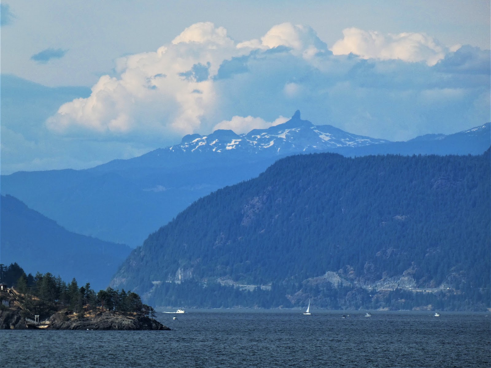
My favorite sight from the ferry ride was of the Black Tusk or t'ak't'ak mu'yin tl'a in7in'a'xe7en in the language of the Squamish people, who considered the strangely shaped peak to be the landing place of the Thunderbird, a principle figure in First Nations mythology. In geological terms, the mountain is a deeply eroded stratovolcano, once like Mt. Baker or Mt. Hood, but now a spikey remnant of the original cone
The Black Tusk from Howe Sound

As noted before, Howe Sound is a glacial fjord, a deep bay with steep flanks that was carved by glaciers. It is a bit difficult to pick out the entrance from the Strait of Georgia because it includes several islands. The sound is 26 miles long, ending at the town of Squamish at the upper end. The urban center of Vancouver is just south of Howe Sound where there is more level ground.

The sound is full of geological delights. We would spend the next four days in the immediate vicinity. That's where we'll pick up the story next time.

Tuesday, August 20, 2019

Travels in Cascadia: Victoria B.C., the City of Mutton Rocks


The next stop in our recent travels through Cascadia was the city of Victoria on Vancouver Island in British Columbia. We got there by way of a ferry from Port Angeles, Washington, as described in the last post. Victoria is an attractive city, one of the most temperate in Canada, given its location on the Pacific shoreline (the adjacent ocean moderates the seasonal temperature extremes). It is also unique in another respect. The city is partially constructed on bedrock (the solid rock that underlies surface soils and sediments), and the land was under a vast 1,000 meter thick ice sheet only 14,000 years ago.

This geologically unique combination means that Victoria is sort of a city of mutton rocks.

I imagine that sentence needs explanation...

The term roche moutonnée describes an asymmetrical glacially scoured rock outcrop that has a smooth slope on the side facing the flowing ice, and a steep cliff on the side where the glacier pulled away from the outcrop ("stoss and lee structure" is a related term). The scale can range from a few meters to many hundreds. They are common features in regions of bedrock that have been scoured by massive continental ice sheets, such as happened in Victoria. One of the tallest hills within the city, Mt. Tolmie (below), is an excellent example. In the picture one can see the gently sloping forested flank on the left side of the hill, and the steeper plucked side to the right.
Mt. Tolmie, a roche moutonnée in Victoria

The problem with roche moutonnée as a geological term is that we geologists can only barely agree on its meaning. It's derived from French, and the "roche" part isn't a problem. It means "rock". But "moutonnée" is the tricky aspect. It can be translated loosely as "sheep" (think "mutton""), but not exactly (French: "mouton"). Moutonnée (with the extra e's) translates to "frizzy", and is taken as a reference to sheep's wool. The term originated in the 1700s with a naturalist named Horace-Bénédict de Saussure (it would be decades before the term "geologist" was coined) who noted that the rocks looked like a type of wig apparently well-known at the time whose locks were held in place with mutton grease. Except that there seem to be few or no references to wigs that were actually called that (the closest version was a tête de mouton).

So we teachers are left with trying to define the term as meaning "rock sheep" based on the nebulous idea that the rocks look like sheep grazing in meadows. Which they really don't. But it's still easier than trying to describe obscure French wigs from the 1700s and mutton grease.

There are consequences to building on such rocky landscapes. There are plenty of large patches of glacial till that are easy to plane off with a bulldozer for building construction, but when the rock crops out, allowances have to be made. Perhaps it might involve blasting to construct a flat foundation. The rock is pretty tough stuff, gabbro, diorite, and greenstone of the Wrangellia terrane, dating back to the era of dinosaurs.

There are problems in this kind of situation. When the Empress Hotel (see the picture above) was constructed in 1904-1905 it was placed partly on solid rock and partly on mud-rich sediments. Complications quickly ensued. The south part of the building subsided several centimeters within the first year and ultimately sank about a meter. It's a real headache for those who must maintain the building.

Still, Victoria is a truly beautiful city, and the city has a unique personality. The city has miles of coastline, and there are dozens of scenic shoreline parks. We pulled up at Cattle Point to look at smaller roches moutonnée along with glacial scour marks and striations. Strangely enough, there was a piano sitting on the bluff. It was brightly painted, there was a bench, and the piano was in tune! I wondered what was going to happen to it if it rained, but then noticed a waterproof cover. We later found that there are five such pianos in the parks, and we were actually treated to a tune by a passing jogger, followed by a song by one of our students!

If you ever have a chance to visit Victoria, enjoy the city, but be sure to follow the shoreline drive to see the glacial heritage of the landscape (as well as seeing some dramatic coastal scenery). But the other thing you should do is to hike or drive to the summit of the mutton rocks of the city. Mt. Tolmie is a good choice within the city limits, or you can go just north of the city to the much higher summit of Mt. Douglas. It's a short hike from the parking lot to a summit with a 360 degree view of the region. The Olympic Mountains are visible across the Strait of Juan de Fuca to the south beyond the city, and the many islands of the Strait of Georgia and Saanich Inlet are visible to the north and east. Glacial polish, striations and grooves are present underfoot.

On the day we were there, I saw some unusual looking clouds far to the southeast. I took a few highly zoomed shots and forget about them until weeks later. I started working with the contrast and exposure of the picture and realized I had captured an image of Mt. Rainier across the Puget Sound. The volcano is more than 130 miles away (below)!

I had three main resources for the geology in and around the city:
The Geology of Southern Vancouver Island by Chris Yorath
Roadside Geology of Southern British Columbia by Bill Mathews and Jim Monger
Geology of British Columbia, A Journey Through Time by Sydney Cannings, JoAnne Nelson, and Richard Cannings.

Thursday, May 9, 2019

There is Still Time to Join the Geotrippers (but not much)! British Columbia, the Channeled Scablands, the Olympic Peninsula and the North Cascades, June 26-July 10, 2019


What are you going to do this summer? Are there places in the world that you've thought of visiting but never made a plan? Maybe we can be of assistance in fulfilling your dreams! The geology and anthropology departments at Modesto Junior College will be conducting a field course dyad that will explore Washington and British Columbia on June 26-July 10, 2019. Anyone with an interest in geology or anthropology is encouraged to join us (if you want to skip the reading and get to the details, scroll down to the bottom of this post).

Our journey will begin in the Seattle area where we'll get our rental vans (yes, you'll need to find your way to Seattle). We'll then head out to the Olympic Peninsula where we'll explore Olympic National Park (including the iconic view from Hurricane Ridge, above). There will be an opportunity to explore some of the rainforest. Cape Flattery and the Makah Nation will be the anthropology focus on one day.

We'll then take the ferry across the Strait of Georgia to the city of Victoria on Vancouver Island. "Island" barely describes a landmass three hundred miles long. It has been inhabited by humans for thousands of years, and we'll be looking for petroglyphs and other archaeological evidence as we explore the south shore and then work our way north through Duncan to Nanaimo.

From Nanaimo, we'll take a ferry back to the North America mainland at Howe Sound. We will spend several days in the Vancouver area, exploring both the coastal mountains and Fraser River delta, and also the extensive museums in the city.

We'll travel the Sea to the Sky Highway, a spectacular route that leads from Vancouver to Whistler and Pemberton, site of the 2010 Winter Olympics. We'll have a chance to observe active glaciers and potentially active volcanoes, including Mt. Garibaldi and the Black Tusk.
You'll have a chance to figure out how this landscape happened...(below).
 We'll return to the United States by way of the Okanogan Valley and we'll then explore one of the strangest landscapes on Earth, the Grand Coulees and Channeled Scablands. The discovery of evidence for the incredible Spokane Floods of the ice ages is one of the great stories of geology.
We'll wrap up the trip by passing over the Cascade Range at North Cascades National Park with a stop along the potentially active Mt. Baker volcano.

This trip is just the latest of MJC’s unique collaboration of field studies in geology and anthropology, taught by anthropology professor Susan Kerr and geology professor Garry Hayes.

When and How? The group will come together in Renton, Washington (near SeaTac Airport and Seattle) on June 26 and will return to SeaTac mid-day on July 10. We will travel in rental vans, and stay in hotels.

Costs: The trip will cost $1,600, which includes transportation, admission fees, accommodations, and teaching materials. Students will be responsible for getting to and from Seattle, and for meals (many of the hotels offer free breakfasts, and some rooms will have microwaves). There will be the tuition costs for six units of semester credit, and the fees for getting or renewing a passport.

Accommodations: We are staying in a variety of motels and hotels. We are assuming double occupancy for married couples, and double to triple occupancy for singles. We will try to accommodate requests for single rooms for a surcharge, but cannot guarantee it. (The earlier your request, the better the chance for getting extra rooms).

Academics: The field courses are worth three semester units each (total of six). Participants will be expected to keep field notes and to complete worksheets and quizzes during the trip.

Contact the professors for more information (hayesg - at - Yosemite.edu or kerrs - at -Yosemite.edu). 

For up-to-date announcements, check out the trip Facebook page at https://www.facebook.com/groups/1920712791360611/ and the MJC Geology information page at http://hayesg.faculty.mjc.edu/GeologyPacificNorthwest.html