Showing posts with label fjord. Show all posts

Thursday, September 19, 2019

Travels in Cascadia: The Southernmost Fjord in Western North America: Howe's that Sound?


Our journey through the Pacific Northwest and British Columbia continued. We had spent several days on Vancouver Island, exploring Goldstream Provincial Park, Mt. Douglas and the Mutton Rocks of Victoria, Sitting Woman Falls, and the gabbro oceanic crust of East Sooke Park. It was now time to head back to the mainland and our goal was to explore the geologic environments of Howe Sound, the southernmost glacial fjord in western North America.

We would spend several days looking at this fascinating geological environment. To get there we would need to take a ferry from Nanaimo on Vancouver Island back to the mainland at Horseshoe Bay inside Howe Sound. We just missed an earlier ferry, so we cooled our heels for a couple of hours in the tourist traps at the ferry terminal. Our attention was distracted by a pair of otters hiding out in the shade beneath the ferry building.

After a few hours we were underway, leaving behind the fairly muted glacial topography of Vancouver Island, and heading towards the decidedly more mountainous country of the mainland. The main contrast was that glacial ice sheets covered Vancouver Island, but the mountains rose above the glaciers on the mainland. We could see the city of Vancouver off to the south.

As we scanned the horizon from the upper deck of the ferry, we could see that we were still definitely in the land of volcanoes. Off to the east we could just make out the lower flanks of Mt. Garibaldi, one of the northernmost of the Cascades Volcanoes. Garibaldi is one of the most unusual of the Cascades because a large portion of the edifice was erupted onto a glacier. When the glacier melted away at the end of the ice age, the flank of the volcano collapsed into the adjacent valley in a series of huge debris flows.
Mt. Garibaldi, with Howe Sound in the foreground


The clouds were playing hide and seek, and mostly 'hide' with the summit of Mt. Baker off to the south in Washington. The glacier-covered peak of Mt. Baker is geologically young, and the mountain seemed on the verge of erupting back in 1975, but it fizzled out to the disappointment of geologists and to the relief of everyone else.
Mt. Baker, partly hidden by clouds, from Howe Sound


My favorite sight from the ferry ride was of the Black Tusk or t'ak't'ak mu'yin tl'a in7in'a'xe7en in the language of the Squamish people, who considered the strangely shaped peak to be the landing place of the Thunderbird, a principle figure in First Nations mythology. In geological terms, the mountain is a deeply eroded stratovolcano, once like Mt. Baker or Mt. Hood, but now a spikey remnant of the original cone
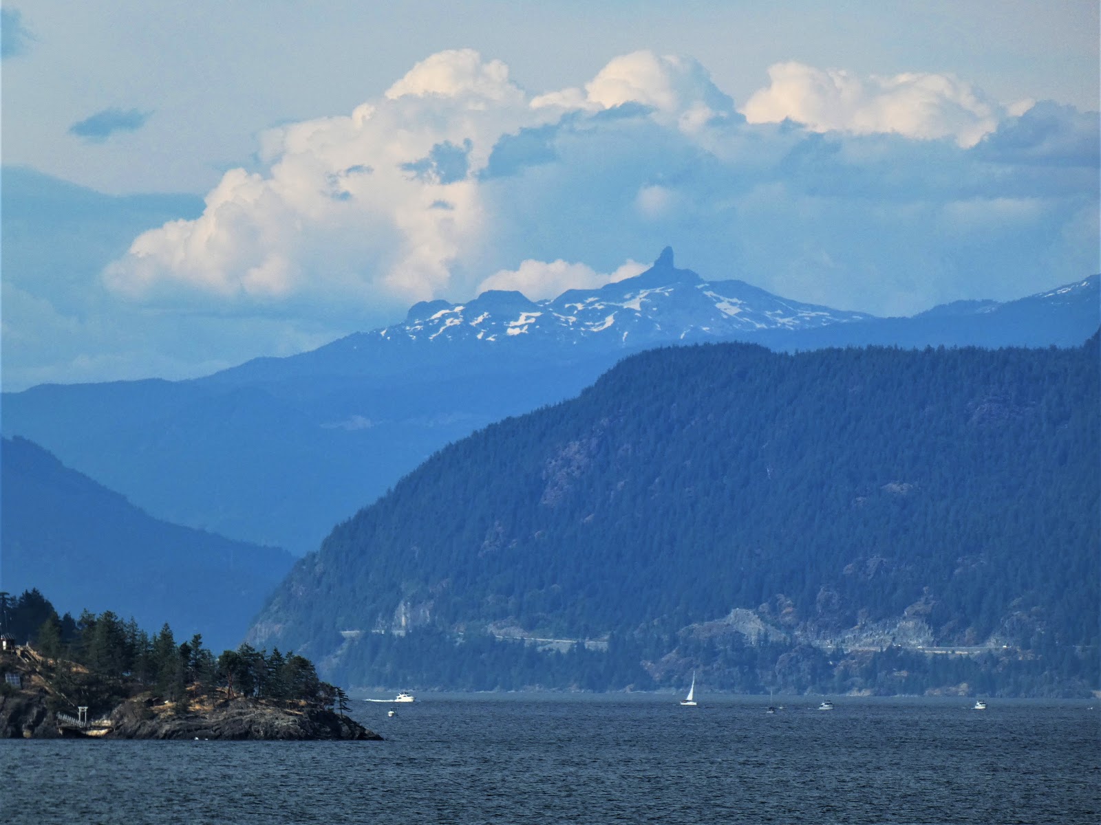
The Black Tusk from Howe Sound

As noted before, Howe Sound is a glacial fjord, a deep bay with steep flanks that was carved by glaciers. It is a bit difficult to pick out the entrance from the Strait of Georgia because it includes several islands. The sound is 26 miles long, ending at the town of Squamish at the upper end. The urban center of Vancouver is just south of Howe Sound where there is more level ground.

The sound is full of geological delights. We would spend the next four days in the immediate vicinity. That's where we'll pick up the story next time.

Wednesday, August 19, 2015

Vagabonding on Dangerous Ground: Exploring North America's Southernmost Fjord

One of the nice things about vagabonding, traveling without a set itinerary, is that one can make allowances for weather. That's a major consideration with a journey through the Pacific Northwest. We stayed an extra day on Vancouver Island, letting a weak storm pass through the region, because I couldn't stand the thought of missing out again on seeing and exploring an extraordinary place, the southernmost fjord in North America.

We missed seeing much of the landscape in and around Howe Sound last year because we were traveling with a large group and had a precise schedule. An unusually powerful summer storm hit the region  as we traveled through. It caused flood damage across British Columbia and Alberta, but we mainly saw rain and very cloudy conditions. Needless to say, I was disappointed. Extremely, teeth-gratingly disappointed. My choice of travel locales on this trip was governed largely by the desire to see Howe Sound and the Sea to the Sky Highway between Vancouver and Whistler.

I reveled in the beauty of the storm-free weather as we boarded the ferry from Nanaimo on Vancouver Island to Horseshoe Bay in Howe Sound on the mainland. The water was sparkling in the sun, and views were practically unobstructed in all directions. We crossed the Strait of Georgia, the northern arm of the Salish Sea, and entered the mouth of Howe Sound. It was my first time seeing a glacial fjord (even though I was there the previous year).

A glacial fjord is simply a drowned glacial trough, a long coastal inlet that is lined by steep cliffs. Glaciers can erode valleys below sea level if the ice is thick enough, but many fjords formed by flooding caused by the rise of sea level that followed the end of the last ice age. The term is Norwegian, and of course Scandinavia is famous for spectacular fjords. But Howe Sound is no slouch when it comes to incredible scenery. And there's a hint of danger, too...
The hazards of living along a subduction zone change as one travels inland. We were now the width of a huge island and a large strait from the trench, so the direct shaking from gigantic earthquakes offshore would be somewhat lessened. But rockfalls and tsunamis would still have to be considered threats. Some tsunamis could even be generated within the fjord by rockfalls. In 1958 at Lituya Bay in Alaska, a quake-generated rockfall produced a gigantic spash that erased trees, rock and soil from the opposite slope to a height of 1,720 feet (520 m). The tsunami moved seaward with heights of between 100-300 feet, removing entire forests and killing several people unlucky enough to be in fishing boats at the mouth of the bay (although several survived the wave and provided eyewitness accounts of the extraordinary event).
Photo by Mrs. Geotripper

The existence of several important transportation corridors, both rails and highways, in Howe Sound has highlighted the dangers of mass wasting. There simply isn't much in the way of flat ground for the placing of rails or asphalt, so engineering problems abound. The original two lane highway was widened and straightened to ease traffic during the 2010 Winter Olympics. Problems with falling rocks and debris floods are constant, with an average of 405 events each year, and a death toll (since 1906) of 50 lives, although 37 of them were due to a single event, a horrific debris flow in 1921.
The other threat is volcanism. The slab of oceanic crust that is subducting off the coast carries water into the Earth's mantle, and a series of reactions lead to the melting of crustal rock. The magma rises to the surface, erupting out and forming a chain of volcanoes called a magmatic arc. Here, in British Columbia at Howe Sound, we were near the northern terminus of the Cascadia arc, and I was particularly anxious to have a look at Mt. Garibaldi and the Black Tusk. I had a brief view of the "tusk", an eroded cinder cone, as we sailed into the sound. There will be a bit more on the volcanoes in a future post.
We drove up the narrow highway and made a brief stop at Porteau Cove Provincial Park. We stopped there last year, but mostly had a view of some rocks up close, and fog. On this day, we had a dramatic view of the sound, and the surrounding glacier-covered peaks.
The water had changed from a dark blue to a turquoise hue. The reason had to do with the glaciers on the high peaks above us. As the ice grinds away at the rock, a fine silt/clay material results, and is carried in the meltwater to the sound below. The finest clay particles can remain in suspension for weeks or months, and that is what produces the unique color of the water in the upper part of the sound.
The main trunk glacier that produced Howe Sound was able to cut far deeper than the smaller tributary glaciers, so the side canyons ended up perched high up on the rim of the main valley. Shannon Falls is an example of one of these hanging valleys. It makes a dramatic cascading drop of  1,100 feet (335 meters) onto the valley floor at the head of the sound.
We reached the upper end of Howe Sound at the town of Squamish, and started the grade up into the mountains at Whistler. At a roadside viewpoint, we stopped and looked back at the head of Howe Sound. It was a much different place than the one we saw last year!
In case you were wondering what we did see last year, here is a shot from Porteau Cove in 2014.
And this was Shannon Falls in 2014. The fog had lifted a bit, so we actually saw the falls back then. I was struck by how feeble the falls were this summer. The drought extends far beyond California...