Showing posts with label Mt. Garibaldi. Show all posts

Thursday, September 19, 2019

Travels in Cascadia: The Southernmost Fjord in Western North America: Howe's that Sound?


Our journey through the Pacific Northwest and British Columbia continued. We had spent several days on Vancouver Island, exploring Goldstream Provincial Park, Mt. Douglas and the Mutton Rocks of Victoria, Sitting Woman Falls, and the gabbro oceanic crust of East Sooke Park. It was now time to head back to the mainland and our goal was to explore the geologic environments of Howe Sound, the southernmost glacial fjord in western North America.

We would spend several days looking at this fascinating geological environment. To get there we would need to take a ferry from Nanaimo on Vancouver Island back to the mainland at Horseshoe Bay inside Howe Sound. We just missed an earlier ferry, so we cooled our heels for a couple of hours in the tourist traps at the ferry terminal. Our attention was distracted by a pair of otters hiding out in the shade beneath the ferry building.

After a few hours we were underway, leaving behind the fairly muted glacial topography of Vancouver Island, and heading towards the decidedly more mountainous country of the mainland. The main contrast was that glacial ice sheets covered Vancouver Island, but the mountains rose above the glaciers on the mainland. We could see the city of Vancouver off to the south.

As we scanned the horizon from the upper deck of the ferry, we could see that we were still definitely in the land of volcanoes. Off to the east we could just make out the lower flanks of Mt. Garibaldi, one of the northernmost of the Cascades Volcanoes. Garibaldi is one of the most unusual of the Cascades because a large portion of the edifice was erupted onto a glacier. When the glacier melted away at the end of the ice age, the flank of the volcano collapsed into the adjacent valley in a series of huge debris flows.
Mt. Garibaldi, with Howe Sound in the foreground


The clouds were playing hide and seek, and mostly 'hide' with the summit of Mt. Baker off to the south in Washington. The glacier-covered peak of Mt. Baker is geologically young, and the mountain seemed on the verge of erupting back in 1975, but it fizzled out to the disappointment of geologists and to the relief of everyone else.
Mt. Baker, partly hidden by clouds, from Howe Sound


My favorite sight from the ferry ride was of the Black Tusk or t'ak't'ak mu'yin tl'a in7in'a'xe7en in the language of the Squamish people, who considered the strangely shaped peak to be the landing place of the Thunderbird, a principle figure in First Nations mythology. In geological terms, the mountain is a deeply eroded stratovolcano, once like Mt. Baker or Mt. Hood, but now a spikey remnant of the original cone
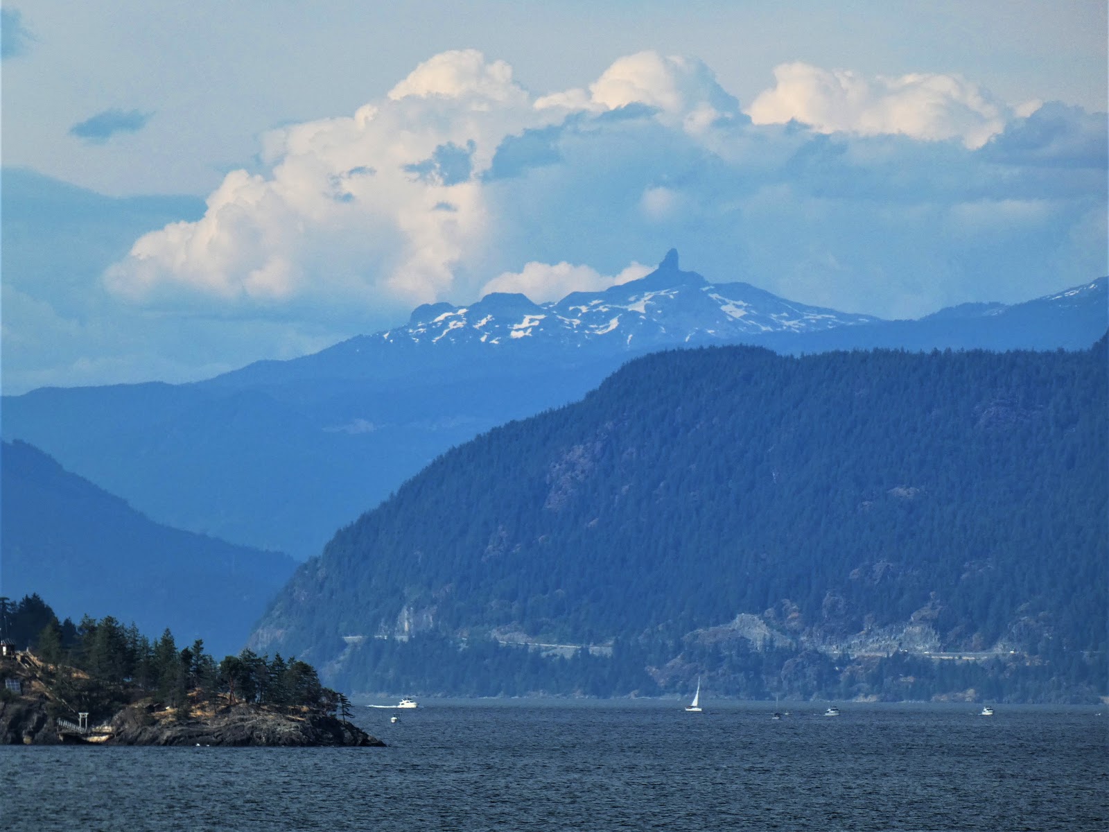
The Black Tusk from Howe Sound

As noted before, Howe Sound is a glacial fjord, a deep bay with steep flanks that was carved by glaciers. It is a bit difficult to pick out the entrance from the Strait of Georgia because it includes several islands. The sound is 26 miles long, ending at the town of Squamish at the upper end. The urban center of Vancouver is just south of Howe Sound where there is more level ground.

The sound is full of geological delights. We would spend the next four days in the immediate vicinity. That's where we'll pick up the story next time.

Saturday, January 20, 2018

A Look Back at Ten Years of Geotripping: Vagabonding on Dangerous Ground, an Exploration of Cascadia

In 2015 I wrote a blog series about driving through the "Most Dangerous Plate Boundary" in the world, but it was actually about driving through a fossil subduction zone that is exposed in the Coast Ranges, Great Valley and Sierra Nevada of Central California. In the summer of 2015, Mrs. Geotripper and I took a long journey along the entire length of a real "dangerous plate boundary", the Cascadia subduction zone, that extends from Northern California to British Columbia. The trip coincided with a media explosion over the very real possibility of a magnitude 9 earthquake along the Pacific Northwest coastline. This resulted in another blog series, Vagabonding on Dangerous Ground. Here is a compilation of the journey...

This was posted on September 13, 2015...

I've finished a new blog series on our exploration of the Cascadia Subduction Zone, so I've compiled all the posts in chronological order so you can get the story the correct sequence. Thanks for all the nice comments, responses, and corrections! Click on the orange titles for the post.

On the Road in the Pacific Northwest: The introduction and overview of the new blog series.

Following the Cascadia Subduction Zone on Highway 101: This post provided the geological background for understanding the hazards of living in the lands influenced by the Cascadia Subduction Zone.

In This Land of the Sasquatch There are Ancient Giants: The first leg of our journey took us through the range of the California Redwoods and the land of black bears that look suspiciously like walking ape-people.

The End is Coming (of the Cascadia Subduction Zone): The end of Cascadia is a slow process, but the zone is disappearing slowly, being replaced by the San Andreas fault. It's also a look at one of the loneliest beaches in California.

A Geologist Walks Onto a Bar in Cascadia: Exploring the unique baymouth bars along the Humboldt county coast.

Northern California's Tsunami Central: Crescent City has a tragic history of tsunamis, especially the one in 1964 that took a dozen lives and destroyed the marina and downtown areas.

This "Dismal Forest Prison" and other problems exploring the Northwest: The Pacific Northwest was particularly difficult to explore and map, at least if you weren't part of the indigenous culture. Here are some accounts of the discovery of Humboldt Bay by land.

Into the Land of Sand, and Exploding Whales: Between Coos Bay and Florence, Oregon, is the longest stretch of sand beaches and dunes in the Pacific Northwest. Yeah, and the whale thing...

Into the Realm of the Devil (and Sea Lions): There are a lot of things named for the devil on the Oregon coast for some reason. And some incredible sea caves occupied by sea lions.

Putting on a Happy Face at Dismal Nitch and Cape Disappointment: We reach the mouth of the Columbia River, where Lewis and Clark reached their goal. It's undergone a great many changes over the years.

Into the Rainforest, Seeing Something Strange...Rain: We explore the Hoh Rainforest in Olympic National Park for the first time, and encounter something strange, at least this year: rain. There was also a fire burning in the rainforest. That's not normal.

The Diverse Landscapes of Olympic National Park: Olympic is one of the most diverse of our national parks, with alpine glaciers, rainforests, and coastlines. It's spectacular.

The Salish Sea and the Strait of Juan de Fuca: Glaciers and tectonics combined to form a seaway east of Vancouver Island and the Olympic Peninsula. It's a unique ecosystem quite distinct from the Pacific Ocean just a few miles away.

Stone Rings, Glaciers, and "Dinosaurs" on the Coast of the Salish Sea: Desecrated burial mounds, avian dinosaurs, and glacial landscapes. Victoria on Vancouver is both a beautiful city and a fascinating place to explore.

Exploring North America's Southernmost Fjord: We take the ferry to the mainland, making landfall inside of the southernmost glacial fjord in North America, Howe Sound in British Columbia (defined here as on the mainland, but connected to the ocean; opinions differ!).

Landing Place of the Thunderbird and the Grimy One, the Volcanoes of British Columbia: Black Tusk and Mt. Garibaldi two of the northernmost volcanoes in the Cascade Range. I missed them last year in the rain, but saw them this time.

Controversial Stone People, Fire and Ice, and an Olympic Legacy: We made it to Whistler and the home of the 2010 Winter Olympics. The stone people were controversial, but the scenery was not. It was spectacular.

Seeing Volcanoes from the Inside Out at Siám' Smánit (Stawamus Chief): Glaciers and granite! Stawamus Chief is a dramatic granitic dome rising high above the end of Howe Sound. It was once the magma chamber of a volcano.

Our Tour of the Greatest National Park I Never Once Set Foot In: North Cascades National Park is a true primeval wilderness. No roads penetrate the park boundaries. But what incredible scenery!

The Geology that Explains Why North Cascades is a Park Divided: The Skagit River may be the most altered water course in the Pacific Northwest, but it provides 20% of Seattle's electricity. It splits a national park in two.

What's East of North (Cascades), A Brief Explore: North Cascades doesn't have all the scenery; the lands to the east are rather spectacular too, and offer some great geology.

Playing Hide and Seek with a Sleeping Monster: Mt. Baker is not the most active volcano in the Cascade Range, but it is capable of great mayhem. It even looked for awhile like it might blow back in 1975.


Danger Follows Us Home (As it does all of us): A Mt. Shasta drive-by (photo) shooting, and a wrap-up of the series. Danger is always with us no matter where we are. It's not to be feared, but respected and prepared for.

Sunday, September 13, 2015

Vagabonding on Dangerous Ground: A Compendium of Posts


I've finished a new blog series on our exploration of the Cascadia Subduction Zone, so I've compiled all the posts in chronological order so you can get the story the correct sequence. Thanks for all the nice comments, responses, and corrections! Click on the gray titles for the post.

On the Road in the Pacific Northwest: The introduction and overview of the new blog series.

Following the Cascadia Subduction Zone on Highway 101: This post provided the geological background for understanding the hazards of living in the lands influenced by the Cascadia Subduction Zone.

In This Land of the Sasquatch There are Ancient Giants: The first leg of our journey took us through the range of the California Redwoods and the land of black bears that look suspiciously like walking ape-people.

The End is Coming (of the Cascadia Subduction Zone): The end of Cascadia is a slow process, but the zone is disappearing slowly, being replaced by the San Andreas fault. It's also a look at one of the loneliest beaches in California.

A Geologist Walks Onto a Bar in Cascadia: Exploring the unique baymouth bars along the Humboldt county coast.

Northern California's Tsunami Central: Crescent City has a tragic history of tsunamis, especially the one in 1964 that took a dozen lives and destroyed the marina and downtown areas.

This "Dismal Forest Prison" and other problems exploring the Northwest: The Pacific Northwest was particularly difficult to explore and map, at least if you weren't part of the indigenous culture. Here are some accounts of the discovery of Humboldt Bay by land.

Into the Land of Sand, and Exploding Whales: Between Coos Bay and Florence, Oregon, is the longest stretch of sand beaches and dunes in the Pacific Northwest. Yeah, and the whale thing...

Into the Realm of the Devil (and Sea Lions): There are a lot of things named for the devil on the Oregon coast for some reason. And some incredible sea caves occupied by sea lions.

Putting on a Happy Face at Dismal Nitch and Cape Disappointment: We reach the mouth of the Columbia River, where Lewis and Clark reached their goal. It's undergone a great many changes over the years.

Into the Rainforest, Seeing Something Strange...Rain: We explore the Hoh Rainforest in Olympic National Park for the first time, and encounter something strange, at least this year: rain. There was also a fire burning in the rainforest. That's not normal.

The Diverse Landscapes of Olympic National Park: Olympic is one of the most diverse of our national parks, with alpine glaciers, rainforests, and coastlines. It's spectacular.

The Salish Sea and the Strait of Juan de Fuca: Glaciers and tectonics combined to form a seaway east of Vancouver Island and the Olympic Peninsula. It's a unique ecosystem quite distinct from the Pacific Ocean just a few miles away.

Stone Rings, Glaciers, and "Dinosaurs" on the Coast of the Salish Sea: Desecrated burial mounds, avian dinosaurs, and glacial landscapes. Victoria on Vancouver is both a beautiful city and a fascinating place to explore.

Exploring North America's Southernmost Fjord: We take the ferry to the mainland, making landfall inside of the southernmost glacial fjord in North America, Howe Sound in British Columbia (defined here as on the mainland, but connected to the ocean; opinions differ!).

Landing Place of the Thunderbird and the Grimy One, the Volcanoes of British Columbia: Black Tusk and Mt. Garibaldi two of the northernmost volcanoes in the Cascade Range. I missed them last year in the rain, but saw them this time.

Controversial Stone People, Fire and Ice, and an Olympic Legacy: We made it to Whistler and the home of the 2010 Winter Olympics. The stone people were controversial, but the scenery was not. It was spectacular.

Seeing Volcanoes from the Inside Out at Siám' Smánit (Stawamus Chief): Glaciers and granite! Stawamus Chief is a dramatic granitic dome rising high above the end of Howe Sound. It was once the magma chamber of a volcano.

Our Tour of the Greatest National Park I Never Once Set Foot In: North Cascades National Park is a true primeval wilderness. No roads penetrate the park boundaries. But what incredible scenery!

The Geology that Explains Why North Cascades is a Park Divided: The Skagit River may be the most altered water course in the Pacific Northwest, but it provides 20% of Seattle's electricity. It splits a national park in two.

What's East of North (Cascades), A Brief Explore: North Cascades doesn't have all the scenery; the lands to the east are rather spectacular too, and offer some great geology.

Playing Hide and Seek with a Sleeping Monster: Mt. Baker is not the most active volcano in the Cascade Range, but it is capable of great mayhem. It even looked for awhile like it might blow back in 1975.


Danger Follows Us Home (As it does all of us): A Mt. Shasta drive-by (photo) shooting, and a wrap-up of the series. Danger is always with us no matter where we are. It's not to be feared, but respected and prepared for.

Friday, August 21, 2015

Vagabonding on Dangerous Ground: Landing Place of the Thunderbird and the Grimy One, the Volcanoes of British Columbia

Nch'kay (Mt. Garibaldi) near Squamish, B.C.  Photo by Mrs. Geotripper
t'ak't'ak mu'yin tl'a in7in'a'xe7en and Nch'kay ("Landing Place of the Thunderbird" and "Grimy One") are the Squamish names for two of the most striking volcanoes in British Columbia. Much more recent colonizers refer to the mountains as Black Tusk and Mt. Garibaldi. I prefer the older names; we should name buildings after people, not mountains. They stand at the far north end of the Cascades Volcanic Arc, and although not as well known as their southern neighbors (at least to those of us in the lower 48), they are a potential threat. Mt. Garibaldi, in particular, is seismically active, although it has not had an eruption in about 10,000 years. Debris avalanches are an ever-present problem, however.
Garibaldi is 2,678 m (8,786 ft) in height, and is one of the more unique volcanoes of the Cascades. Much of the mountain erupted on top of a glacial ice sheet, so that when the glaciers melted back, around half of the edifice collapsed in a series of debris avalanches and mudflows. Mass wasting events have continued into modern times, and some of the slopes are considered dangerous enough to limit development in the areas affected. The oldest lava flows date to around 250,000 years ago and are composed of mostly silica-rich lavas such as dacite and rhyolite. The mountain doesn't show much evidence of more violent ash eruptions.
I was incredibly disappointed when clouds obscured our view of Garibaldi on our previous trip through the area, so our trip a few weeks ago was especially gratifying. As it turned out, we took just a few pictures from a pullout with lots of overhead wires, thinking we would get more the next day when we had a few more hours to spare. As luck would have it, the next day was more cloudy...such a surprise in the Pacific Northwest! These were our only pictures of the peak.

The story was very nearly the same with t'ak't'ak mu'yin tl'a in7in'a'xe7en (Black Tusk). We got some distant shots of the peak from the glacial fjord of Howe Sound. The next day we snapped a few pictures as clouds chased around the uniquely shaped summit. As noted in the title of the blog, the name refers to the Landing Place of the Thunderbird. The black color is said to result from the constant lightning strikes associated with the legendary bird.
t'ak't'ak mu'yin tl'a in7in'a'xe7en (Black Tusk), from the Whistler Olympic Venue. Photo by Mrs. Geotripper
The Tusk is 2,319 m (7,608 ft) and much older than Garibaldi. The main peak developed from eruptions around 1.1-1.3 million years ago, forming a stratovolcano. During a subsequent lull, most of the mountain eroded away. The last eruption took place around 170,000 years ago, so the peak is most likely extinct. Other cones in the area have been active in the last few tens of thousands of years.

I was extremely happy to have seen the volcanoes, but I was equally impressed with the other scenery as well. We spent a night in Whistler, and then did something significant: we turned around. The vagabonders were now starting for home, but there was plenty more to see. More posts to come!