Showing posts with label Joshua Tree National Park. Show all posts

Friday, February 21, 2020

The Islands of Interior California: A New Geotripper Series


I've always been fascinated by islands. I visit the Hawaiian Islands every chance I get, and I am literally haunted by the vast expanses of open ocean that separate the islands from any other landmasses. It's an odd combination of loneliness and wonder. It's not something you ever feel when you are staying in Waikiki hotels and sunning yourself on a crowded beach. The sense of isolation comes when you spend time in the rainforests, the alpine deserts, and the barren volcano slopes. When you read about and experience the incredible biological isolation, it becomes an incredible story of survival and adaptation that has produced hundreds of unique endemic species found nowhere else in the world.

Which leads to a question: what does that have to do with a bunch of pictures of localities in the California desert?

I was in Death Valley National Park for much of the past week, and while I was teaching a field course, I also had a few moments of observation and reflection about life in the desert. I was watching for bird species in particular, and I was struck by an odd contradiction: Death Valley (Furnace Creek specifically) has more bird species (339) than my county in California's Great Valley (315). It doesn't seem possible, since conditions are far more benign at home, and in fact the Great Valley can support vastly greater numbers of birds. But Death Valley has a way of forcing more species together in one place where they can be seen and recorded...it is a system of biological islands. The islands are made of water, and the intervening space is largely barren land.
The concept of biologic islands in a landscape is not a new concept at all, so I am not introducing any kind of new idea here. It's just that I sensed the concept more than usual during the recent trip. So in the next few posts I want to describe some of the unique and different "islands" that exist in the California desert, and the geological conditions that caused them. Some of these we explored last week, but as I considered the idea of a series, I thought of a few unique spots I've visited in earlier journeys, so I will include a few of them as well.
Coming up in the next post: the spot that made me think of islands in the first place...


Part 1: The Littlest Islands of All
Part 2: The Pygmy Mammoths and the Doomed Sky Islands
Part 3: There's a Reason Why I Don't Hug Ducks

Monday, April 8, 2013

Joshua Trees Blooming Across the Southwest: Is it a problem or just a good year?

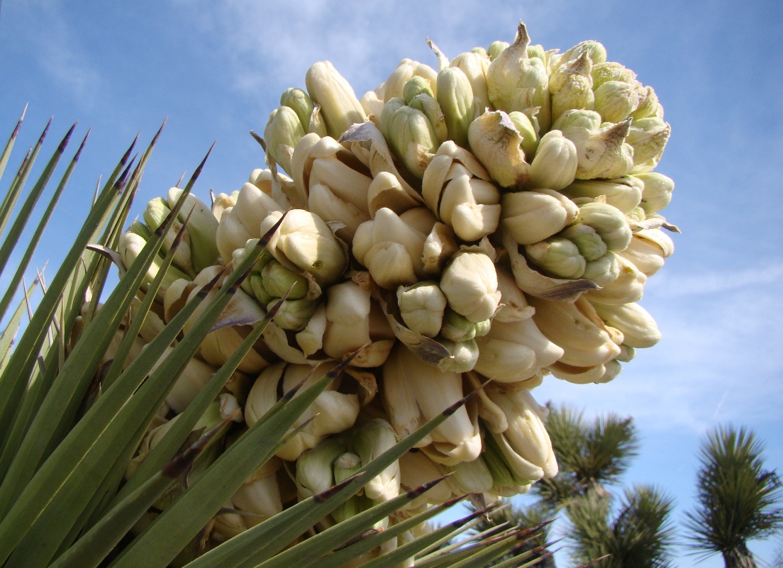
During my travels a few weeks back, I noticed a lot of Joshua trees were blooming along Highway 138. We stopped and snapped a few close-ups without giving it much thought. I knew they bloom off and on in different parts of the Mojave Desert. It has come to my attention, via the Press-Enterprise of Riverside, that the Joshua trees are actually blooming everywhere in the Mojave this year. It's unusual, with millions of the trees producing flowers.
According to the article, biologists are not in agreement about what this means. Some seem to think that the bloom is evidence of plentiful soil-water conditions because of extensive late summer-early fall rainstorms.  Others point to two years of overall severe drought, and average temperatures that are 2-3 degrees above average. The trees are reproducing because of stress, a sort of last gasp to produce seed before dying.
Being a geologist, I can't speak to the precise reason for the once-in-a-lifetime bloom, but geologists have provided some perspective about the prospect for the species' survival. Global warming is in fact leading to higher temperatures across the southwest, and the trees must propagate at higher elevations to survive as a species. This has become difficult over the last few thousand years, because there are no longer any grazing animals that can consume the fruits and spread the seed via their droppings.
The last far-ranging animal that did so was the Shasta ground sloth (Nothrotheriops shastensi) , which went extinct across the southwest more than 12,000 years ago. Without the animals to spread the seeds, they can only fall to the ground underneath the parent tree. There are some fears that the Joshua tree will disappear from its namesake National Park in a few generations.
And that would be a real shame. They are beautiful trees.

Friday, November 18, 2011

A Soggy Day in Joshua Tree National Park: On the road with the NAGT

I spent the last weekend geotripping in Joshua Tree National Park with fellow members of the Far Western Section of the National Association of Geoscience Teachers. We hold these meetings twice a year at locations throughout California, Nevada and Hawaii. They are a great way to share teaching ideas and to collect samples and photos of some of the most spectacular scenery on the planet.

Part of our trip was an exploration of the Geology Road Tour in the middle of the park. The road is an unpaved track that is recommended for four-wheel drive vehicles. We would try to see if that was true on a rainy day! 
It was only sprinkling at first, as we crossed the Queen Valley pediment. Here and there inselbergs rose from the flat valley floor. These 'islands' of rocks that are remnants of mountain ridges that eroded away long ago.

The process of erosion continues into the present day. Can you see the horizontal scars across the boulders in the pictures above and below? These are areas of intense chemical weathering that formed when the soil levels were about 6-7 feet higher than today. The soils have eroded away within the last 20,000 years or so.
Another interesting form of erosion on these granite boulders is the development of tafoni, the hollows and honeycomb pits that occur on some boulders. The origin of the pits is somewhat unclear, but is no doubt a phenomenon of chemical weathering, possibly when the rock was still buried in the soil.
The hollow above was big enough to sit in. Others have had the idea of using the hole for shelter, as there was a grinding hole in the floor of the shallow cave. I also noticed a lot of charcoal in the soil at the site, meaning that the site was also utilized as a campsite by the local Native Americans.

We passed Malapai Hill, a 400 foot high basaltic intrusion. The volcanism resulted from decompression and partial melting of mantle material during a "reorganization" of the crust of southern California as the San Andreas fault system was taking shape. We didn't have time to check it out, but a climb of the hill reveals some nice examples of columnar jointing and fragments of mantle materials in the basalt.
Malapai Hill, photo by Mrs. Geotripper
We dropped down into Pleasant Valley, although with the building storm it was looking less and less pleasant by the moment. The abrupt valley wall marks the trace of the Blue Cut fault, a left lateral strike-slip fault that trends eastward through the park.
We stopped for a look at the Gold Coin Mine (not much equipment left), and searched for a few petroglyphs on the dark metamorphic rocks at the mine site.
At the contact with the granite, I saw a very nice example of a xenolith ('alien stone'), a piece of older rock that was incorporated into the granite when it was still molten. The xenolith was more resistant to erosion, and now stands out.
The weather was getting nastier by the second. The road crossed a playa surface in the center of Pleasant Valley. After the first eight cars passed through, the surface had become 'unstable', for lack of a better term. For the first time in five years of driving my Subaru, I went fishtailing on a road. My car has been stable on all manner of icy and snowy surfaces, but this was...fun. When we left two hours later, other cars were driving down the one way road. I wonder how they fared.
At the other end of the valley we found some of the most interesting rocks, a series of aplite dikes cutting across the Proterozoic Pinto Gneiss. These rocks are part of a complex that includes the oldest rocks in California (and part of an extensive belt of mountains that once extended across the southern United States).
 The rocks have been intricately folded and intruded by small granite veins. The complex chemical interactions have resulted in mineralization, leading many miners to seek out valuable ores in these rocks, mostly without success.
We continued around the one-way loop, on not too unreasonable roads while the rain continued to pour down on us. Luckily the playa surface did not extend to the other end of the loop, and we had no problems crossing the valley.
The view across the valley was interesting...our road out could be seen meandering up the alluvial slope. The inselbergs from the first part of the road tour can be seen on the skyline through the falling rain.
We made it back to the paved highway without incident, but the trip was cut a bit short because our last destination was Key's View. On a normal desert day, the view is incredible, looking across the Coachella Valley to Salton Sea, the San Andreas fault, and the San Jacinto Mountains. But not on this particular afternoon. The 30% chance of showers had turned into a full-fledged storm, so we headed back to town.

A trip spoiled by rain? Absolutely not. There is nothing quite like the sights and smells of a rainstorm in the desert. It was a great day!

Sunday, November 13, 2011

Bizarro Rocks Day and a Roadrunner

We were on the road this weekend, attending the fall meeting of the Far Western Section of the National Association of Geoscience Teachers. When geologist-teachers get together, we may talk about teaching, but we make sure our activities revolve around geology. We explore.

The sponsor of our meeting was Copper Mountain College, which serves the towns of Yucca Valley and Twentynine Palms. The towns are right next to Joshua Tree National Park which sits astride the boundary between the Mojave and Sonoran Deserts in Southern California. One group explored the scarps produced by the 1992 Landers Earthquake, a 7.6 temblor that produced a prominent scarp that is still visible today. The other trip was a tour of a park named for an odd tree, but whose other distinction is the bizarro rocks it has. Joshua Tree is a showcase for plutonic processes, with thousands of acres of weirdly weathered granitic boulders.
This is a brief post before I hit the long road home, but here are a smattering of photos of my favorite outcrops. They include the very colorful lichens I found in sheltered spots. Lichens are an entire ecosystem of lifeforms in miniature, a symbiotic relationship between algae and fungi.
And then there was the Triassic megacrystic Twentynine Palms quartz monzonite. I've seen plenty of porphyritic granitic rocks before, but a canyon filled with giant boulders of this stuff was just extraordinary.
I could swear I heard a little "beep-beep", and there it was, a little roadrunner wondering what we were up to. More pics later!

Wednesday, November 9, 2011

Don't Take Joshua Tree for Granite: The Fall Meeting of the Far Western Section of the National Association of Geoscience Teachers

There is still time to see one of California's most unique national parks!
(The folllowing is re-posted with minor edits from Teaching the Earth Sciences, the blog of the Far Western Section of the National Association of Geoscience Teachers and from Geotripper on Oct. 1; registration forms, maps and more information on the Far Western Section website)

Joshua Tree National Park is one of the most unique desert environments to be found anywhere in North America (See a representative journey with Geotripper here). Sitting astride the boundary zone between the Mojave and Sonoran deserts, the park displays a startling variety of plant and animal species, and stunning displays of a Proterozoic metamorphic complex and Mesozoic plutonic rocks. It is a great place to learn about geology.

Copper Mountain College will be the host for the Fall 2011 meeting, which will include explorations of the park, and a journey to the interior of the Mojave to see the scarps from the 1992 Landers earthquake, still starkly obvious after two decades. The magnitude 7.3 quake killed two and produced a fracture that crossed fifty miles of desert.

The Far Western Section of the National Association of Geoscience Teachers invites anyone interested in the geological sciences to join them, including students (especially students!). Membership in NAGT is not required. This is a wonderful opportunity to see a fascinating corner of California's geology, and a chance to meet earth science teachers from all over California and Nevada (Hawaii is in our section too). It is an exciting and economic way to see some of southern California's most incredible geology.

Friday November 11, 2011
6:00 PM Meet at Copper Mountain College Bell Center Community Room for Registration 
(On-site registration cost estimate is $50.)
7:00 PM NAGT Far Western Section Board Meeting
8:00 - 9:00 PM Registration
Saturday November 12, 2011
8:00 - 10:00 AM Meet at the Bell Center Community Room for Registration
10:00 AM – 5:00 PM Field Trips (Choose One)
Field Trip Number 1
Landers Earthquake: Scarps still visible after 20 years plus Pioneer Town: Dating of a Miocene(?) erosional surface – Bob Reynolds
Field Trip Number 2 
Geology of Joshua Tree National Park – Bruce Bridenbecker

Presentation: 6:00 – 9:00 PM Evening Social with Lecture on Mines and Mining in Joshua Tree National Park - Dee Trent
Sunday November 13, 2011
8:00 AM Meet at Bell Center Parking Lot for Field Trip to Desert Queen Mine – Dee Trent
Field Trip should conclude by 2:00 or 3:00 PM.                                           
Logistics:

Joshua Tree Area Services
For a directory of area motels and restaurants visit the Joshua Tree Chamber of Commerce Web Site at http://www.joshuatreechamber.org/.
Joshua Tree Area Camping
Indian Cove is located 13 miles east of Joshua Tree Village and 10 miles west of Twentynine Palms on the north side of the Wonderland of Rocks. Indian Cove Road dead-ends at this secluded area. Campers register at the ranger station located at the entrance to the Indian Cove area. Water is also available there.

Contact Bruce Bridenbecker for additional information.

Saturday, October 1, 2011

Come and See Joshua Tree National Park with the Far Western Section of NAGT, November 11-13

(Cross-posted with minor edits from Teaching the Earth Sciences, the blog of the Far Western Section of the National Association of Geoscience Teachers)

Joshua Tree National Park is one of the most unique desert environments to be found anywhere in North America (See a representative journey with Geotripper here). Sitting astride the boundary zone between the Mojave and Sonoran deserts, the park displays a startling variety of plant and animal species, and stunning displays of a Proterozoic metamorphic complex and Mesozoic plutonic rocks. It is a great place to learn about geology.

Copper Mountain College will be the host for the Fall 2011 meeting, which will include explorations of the park, and a journey to the interior of the Mojave to see the scarps from the 1992 Landers earthquake, still starkly obvious after two decades. The magnitude 7.3 quake killed two and produced a fracture that crossed fifty miles of desert.

The Far Western Section of the National Association of Geoscience Teachers invites anyone interested in the geological sciences to join them, including students (especially students!). Membership in NAGT is not required. This is a wonderful opportunity to see a fascinating corner of California's geology, and a chance to meet earth science teachers from all over California and Nevada (Hawaii is in our section too). It is an exciting and economic way to see some of southern California's most incredible geology.

Friday November 11, 2011
6:00 PM Meet at Copper Mountain College Bell Center Community Room for Registration 
(On-site registration cost estimate is $50.)
7:00 PM NAGT Far Western Section Board Meeting
8:00 - 9:00 PM Registration
Saturday November 12, 2011
8:00 - 10:00 AM Meet at the Bell Center Community Room for Registration
10:00 AM – 5:00 PM Field Trips (Choose One)
Field Trip Number 1
Landers Earthquake: Scarps still visible after 20 years plus Pioneer Town: Dating of a Miocene(?) erosional surface – Bob Reynolds
Field Trip Number 2 
Geology of Joshua Tree National Park – Bruce Bridenbecker

Presentation: 6:00 – 9:00 PM Evening Social with Lecture on Mines and Mining in Joshua Tree National Park - Dee Trent
Sunday November 13, 2011
8:00 AM Meet at Bell Center Parking Lot for Field Trip to Desert Queen Mine – Dee Trent
Field Trip should conclude by 2:00 or 3:00 PM.                                           
Logistics:

Joshua Tree Area Services
For a directory of area motels and restaurants visit the Joshua Tree Chamber of Commerce Web Site at http://www.joshuatreechamber.org/.
Joshua Tree Area Camping
Indian Cove is located 13 miles east of Joshua Tree Village and 10 miles west of Twentynine Palms on the north side of the Wonderland of Rocks. Indian Cove Road dead-ends at this secluded area. Campers register at the ranger station located at the entrance to the Indian Cove area. Water is also available there.

Contact Bruce Bridenbecker for additional information.

Wednesday, June 1, 2011

Springtime in the California Desert: Miscellany of Life at Joshua Tree

Wrapping up a week of posts on Joshua Tree National Park, I am offering up a miscellany of life at the unique park in Southern California. A visit in the middle of May is a bit past the height of spring bloom, but there were a few flowers left to enjoy, no doubt assisted by the cool spring. It certainly didn't feel like summer out there.

One of the most dramatic flowers we saw was the ocotillo, a Colorado Desert species that lives in the lower elevations of the park. The ocotillos near Cottonwood Springs were bright with color.
One of the oddest corners of the park is the Cholla Garden at the western end of the Pinto Basin. Chollas are one of the most viciously defended plants one will ever come across. The thorns of the plant are hooked in such a way that if you brush against it, the branch will break off and stick to your skin, by the painful thorns. When you try to brush it off, the thorns stick to your hand. A comb is a vital piece of hiking equipment when hiking in cholla country.

The tendency to break off, besides leading to the "jumping" legend, is also an efficient way of propagating the species. The broken branches can sprout when they get dropped off at a new location.

In most places of the lower desert of Joshua Tree the chollas are widely dispersed, but at Cholla Garden, the chollas are growing in a nearly pure stand, probably due to perfect soil conditions.
Despite the nasty reputation, the Jumping Cholla has a beautiful flower, as can be seen below.
There were a lot of diminutive flowers to be found across the desert, one of which I didn't have any resources to identify. Any help out there?
No problem identifying this one, though. The beavertail cactus is found all over, and the blooms are distinctive...
The rich vegetation was bringing out all manner of insects and birds and reptiles. At the south entrance of the park, I caught one I've never noticed before. It turns out to be a gnatcatcher, perhaps the Blacktailed or California species.
The presence of flowers meant rich time for the hummingbirds, not a species I usually associate with the desert. I saw this one near the Barker Dam trailhead.
There are the usual reptiles. This lizard was well-camouflaged at the base of a fan palm at Cottonwood Springs. I'm assuming a Western Fence Lizard, but will appreciate corrections.
Finally, a mystery beast from the desert. I saw this...something or another...walking across the desert in the Pinto Basin. I thought some kind of wasp from the size, but I haven't a clue what it really is or what that...thing...is on its back. Anyone want to pitch in here?

Tuesday, May 31, 2011

Weird Geology: Accretionary Wedge #34...Our Human Nightmares

Well, how about that? I was trying to figure out how to squeeze in a bizarre shot from my recent trip to Joshua Tree National Park, and the 34th Accretionary Wedge announcement drops in my mailbox, courtesy of Dana at En Tequila es Verdad:

Geology can be strange. Outrageous. Bizarre. I'm sure you've all run into formations and landscapes and concepts that have left you scratching your head. Maybe they got less weird later. Maybe they stayed strange. But however transient or permanent that weirdness was, it got weird.

So tell us about it. Hit us with the strangest stuff you've got.

I'm late to the party, but what's new?I see a lot of weird stuff in my travels, but what strikes me isn't so much the geology, but our weird response to the geology. Can you look at the rock in the picture at the beginning of the post and not see the face of monster trying to emerge from the ground? The rock results from a random process of weathering and erosion, but see it from the right angle, and the rock becomes of mythical story of beasts and human nightmares and heroes on quests. Perseus fought Medusa, who turned men to stone. Tree molds in Hawaiian lava flows were people turned to stone (above). The volcanic necks of the Four Corners region were the monsters who were vanquished by the Navajo Twins Monster Slayer and Child-Born-of-Water (below).Pareidolia is a psychological phenomenon "involving a vague and random stimulus (often an image or sound) being perceived as significant. Common examples include seeing images of animals or faces in clouds, the man in the moon or the Moon rabbit, and hearing hidden messages on records played in reverse". It's part of being human, the recognition of human faces being one of the most important skills of a newborn baby.

Of course, such things can get out of hand when we start seeing Jesus on tortillas, or faces on Mars that are obviously signs of Martian civilization (I thought it was Elvis myself). Or the Devil smiling in the smoke and ash of the Twin Towers burning (wasn't there enough evil in the hearts of the terrorists?).

Monday, May 30, 2011

What's Eating the Joshua Trees? What's Not Eating Them?

For some reason, the powers-that-be somehow failed to call the incredible geological desert in Southern California "Great Big Granite Boulders National Park". They called it "Joshua Tree National Park" instead. I don't quite understand, but that's the way things go sometimes. Really though, the bizarre little 'trees' have a geological history, and it may be their undoing.
The Joshua Tree is actually a member of the yucca family (Yucca brevifolia, meaning short-leaved yucca), and is so closely associated with the Mohave Desert that the boundaries of the one practically coincide with the other. The "trees" grow to a height of 35-40 feet, and are a centerpiece of the Mojave ecosystem, as many animals shelter within the tree and underneath it. The trees have a symbiotic relationship with the Yucca Moth, in which the moth is pretty much the only organism that pollenizes the flowers, and the larvae of the moth pretty much eat only the seeds of the Joshua Tree.
The iconic trees of Joshua Tree National Park are threatened, and as is often the case, we have met the enemy, and he is us. Human generated global warming is raising temperatures in the California Desert, just as it is everywhere else. Joshua Trees are sensitive to such climate change and are no longer propagating in the hotter areas of the park. As the climate warms, more and more trees in the lower edges of the desert will disappear. Normally they would propagate in higher cooler parts of the park, but there is a complication...the problem is a load of crap, or more properly a bunch of dung that is no longer being made.
Today, the only animal that transports Joshua Tree seeds is the woodrat, but they don't move much more than a 100-150 feet from the trees. That's not far enough to get the seeds to higher, cooler elevations, and so there is a possibility that within 50-100 years, most of the Joshua Trees will be gone from Joshua Tree National Park, just as the glaciers will be gone from Glacier National Park. There will be places at the north edge of their range where they will be able to survive, but they may have trouble getting there without human assistance.

So how did the trees get around in the past? That's where the dung comes in (or out...). It seems that we have discovered the droppings of giant ground sloths which once lived all across the southwest. It seems odd that we would have examples of their, uh, reprocessed food, but some of them favored dry caves and there are lots of samples to work with. And they contain a lot of Joshua Tree seeds and leaves. It is pretty clear that sloths provided mobility to the seeds of the Joshua Tree, and when they went extinct 12,000-13,000 years ago, the range of the Joshua Tree began to decline during the climate disturbances in subsequent Holocene time.
The picture above is a Harlan's Ground Sloth on exhibit at the Fossil Discovery Center near Madera in Central California. Despite the ferocious looking claws, it was probably a rather peaceful creature. I just hate that we cannot witness the wonderful menagerie of creatures that lived in North America just a few thousand years ago, although a few were probably the stuff of human nightmares (a future blog on this will be forthcoming). It occurs to me that instead of having humans simply plant Joshua Trees to insure their survival, we should be following a more logical solution. Doesn't it make more sense to use the DNA of the sloths to reproduce new sloths a la "Jurassic Park", and then release them into the wild to do the work that they were meant to do? How hard could it be, really?

For more info on the Joshua Tree and climate change problem check out this NPR story.