Showing posts with label California gold rush. Show all posts

Tuesday, September 12, 2023

A Short Mining History and Geology of the California Gold Rush

Note: I've maintained a website at MJC for quite a few years for the use of my students, and the website is being erased this year for online security reasons. I wanted to keep some of the information, so I am presenting it here, hoping some of you might find it interesting. This particular blog is a review of one of California's seminal events (for better or worse), the Gold Rush of 1848. I borrowed from a number of sources, listed in the references at the end.

Let's start at the beginning and have a look at the basics of gold:

Gold Nugget at the California State Mineral Exhibit in Mariposa. This incredible sample stolen and melted down for a few drug dollars several years ago, a horrible loss.

Chemical Symbol: Au

Atomic Number: 79

Atomic weight: 196.967

Specific Gravity: 19.3 (19.3 times as heavy as an equivalent volume of water; twice as heavy as pure lead; 1 cubic foot weighs over 1/2 ton)

Hardness: 2.5-3 on the Moh's hardness scale (teeth are harder, miners are sometimes pictured biting nuggets to test the authenticity - fool's gold is harder)

Melting point:1,945 degrees F

Boiling point: 5,378 degrees F

Crystal System: Cubic

Gold crystal at the California State Mineral Exhibit in Mariposa. Such crystals are quite rare. 

Gold is the most malleable and ductile of all metals.

One ounce of gold can be stretched into a wire more than 40 miles long.

Gold can be worked into a layer 1 millionth of an inch thick (it has been used on the face masks of astronaut's space suits as a shield).

Gold is Inert, therefore it does not corrode.

Gold is an excellent conductor of electricity

All of the gold ever mined in all of human history would fill a cube only 60 feet on a side!

Fricot Nugget at California State Mineral Exhibit in Mariposa is an extraordinary mass of crystalline gold. At about 13 pounds (201 troy ounces), it is thought to be the largest remaining nugget from the Gold Rush days in California. Other larger specimens were simply melted down.

How Did the Gold Get There?

Gold is present in very small amounts in literally all rocks and even in ocean water; but to be mined economically, it must be concentrated. Even so, the richest gold deposits may contain only a fraction of an ounce per ton.

Around 400 million years ago, California was a different place. It didn't even exist as land, and instead, lay at the bottom of the sea. The Pacific shoreline lay to the east, in present day Utah and Arizona. To the west, large volcanic islands erupted ash and lavas onto the sea floor. Hot springs on the ocean floor built up huge deposits of sulfide mineral deposits.

At various times between 400 and 200 million years ago, titanic crustal forces caused the offshore islands to collide with the American continent, crushing and folding the rocks derived from the sea floor and volcanoes (Keep in mind that this was still a slow process, with movements of only a few inches per year). The rocks, scraped off the sea floor and collected from innumerable volcanic eruptions, became the metamorphic rocks that make up the bedrock of the Mother Lode region.

Typical Mother Lode scenery in the vicinity of Bagby Grade north of Mariposa. Lake McClure on the Merced River in the middle of the picture.

Beginning about 200 million years ago, massive shifts of the tectonic plates that encircle the earth caused the sea floor crust to be pushed beneath the American continent, where it heated up and melted into huge molten masses of magma. These so-called subduction zones are in modern times responsible for the volcanoes and sometimes violent earthquakes of the Cascade- and Andes mountain ranges. The molten rock forced its way upward through the crust and slowly cooled to become the granitic rock that makes up most of the Sierra Nevada today.

Half Dome and Clouds Rest in Yosemite Valley, as seen from Highway 49 near Bagby Grade. The High Sierra has vast outcrops of granitic rock.

Water, derived from rain and snow, percolated into the ground in the Mother Lode region. Following fractures and cracks left by millions of years of geologic mayhem, the water came closer and closer to the hot molten magmas. At these elevated temperatures, water dissolved otherwise stable materials including quartz, gold, silver, copper and zinc.

The metal and sulfide laden stew of hot water then rose along fractures adjacent to the Melones Fault Zone in the Mother Lode. As it cooled, it began to precipitate the mineral riches that it carried as large quartz veins with varying proportions of gold and silver, along with iron, copper and zinc sulfides. Some may have even emerged at the surface as hot springs, like those that exist today near Reno and Carson City. This process is called hydrothermal mineralization.

At least twice in the last hundred million years, the Sierra Nevada rose into a mighty mountain range only to be attacked by the forces of erosion: water, ice and wind. Many thousands of feet of rock were stripped away, and the gold veins were exposed to the elements. Rivers carried fragments of gold downstream and on into the Great Valley. During the most recent mountain-building episode, which may have begun within the last 10 million years or so, many ancient streambeds (which had their headwaters in Nevada) were abandoned, and the thick gravels they contained were left as isolated patches on high mountainsides, and on the plateau-like topography between deep canyons. In some cases, lava flows covered and protected the gold-bearing gravels. All that remained was for the gold to be discovered by human beings who valued the strange metal.

Ancient stream gravels near North Bloomfield in the Mother Lode

How Did They Get The Gold Out?

Numerous methods of mining the gold of the Mother Lode were utilized. Some of these methods were pioneered here.

Placering:

When the Gold Rush began, few of the people in California knew anything of the methods used to procure gold from the quartz veins and river gravels. Because of the richness of the river gravels in the earliest days, panning was an early method of choice, but it was inefficient, back-breaking labor. Panning soon gave way to cradles, rockers, and long-toms. Hardworking miners could process several cubic yards a day.

Modern-day 49ers at North Bloomfield

It is difficult to assess the total production of these placering methods, but in the period of the Gold Rush itself (roughly 1848-1853), perhaps 10-12 million ounces of gold were produced (worth many billions of dollars at today's prices). This was the era when the individual could hope to strike it rich, and quite a few lucky miners did. Most barely made a living at the placers, and as the boom waned, many drifted away, or found work with some of the industrial mines that were starting to develop. Other miners began looking at the canyon walls and terraces, and some of them noticed the terrace gravels. Gold must be there, but how could they get it out? . . .

Hydraulic Mining:

In 1853, the first successful hydraulic nozzle was brought to bear on the terrace gravels. In this method, a high pressure hose was used to direct a violent stream of water at the slopes and cliffs containing the terrace gravels and their load of gold. The loosened sediment would be washed over a set of riffles constructed out of bedrock. At intervals, the hoses were turned off, and the gold collected from the bottom of the huge sluices. By 1884, some 11 million ounces of gold had been produced by this method. Hydraulic mining was particularly successful due to the relatively low labor costs coupled with the fact that many hundreds of cubic yards of gravel could be processed in a matter of hours.

One of the hydraulic nozzles utilized at North Bloomfield

Water was brought onto the mine property by a series of flumes and ditches that connected to reservoirs that had been constructed in the high country in and around the Tahoe Crest (today's Emigrant Wilderness). By 1865, some 5,000 miles of waterways had been constructed across the west slope of the Sierra. When hydraulic mining was abandoned, many of these canals and reservoirs became the infrastructure for the generation of hydroelectric power.

Debris-filled channel in the northern Mother Lode caused by hydraulic mining. The tree "trunk" is actually the 60-foot level of the original tree.

Unfortunately, hydraulic mining had a devastating effect on the local environment. Entire hillsides and ridge tops were removed by the hoses. Vast amounts of sediment filled Sierra river channels, and spread into the Central Valley and San Francisco Bay. In response to legal challenges by farmers in the Central Valley (who were suffering serious flooding as a direct result of the hydraulic mining), the method was severely restricted as of 1884, and largely abandoned after that time. Meanwhile, attention shifted to the sediments of the Central Valley. Gold had been carried for millennia into the fine grained sediments of the valley floor, but so far, no efficient method had been found to profitably mine the resource . . .

Dredging:

The gold contained in the flood plains of the rivers that flowed out of the Mother Lode was very fine, widely disseminated throughout the sediment, and very hard to concentrate with the methods available during the early part of the Gold Rush. The first attempt at using a dredge to mine gold in 1853 was a failure (it immediately sank). It was not until 1898 that a dredge was used profitably to mine gold on the Feather River. The method was a great success, and dredges were active through the 1960's. More than 20 million ounces were mined this way.


Dredges were profitable because they could move and process thousands of cubic yards per day with minimal labor costs. Many dredges could operate at a profit when the sediment they processed contained only 10-15 cents of gold per cubic yard.

In essence, dredges were floating factories with a huge set of buckets at one end, sediment sorters, sieves and screens in the center for processing sediment, and a crane at the other end for distributing the waste material (tailings). The buckets dug sediment out of one end of the pond, sometimes to a depth of 100 feet or more, and the tailings were dumped at the other end. Working this way a dredge could navigate across the landscape, carrying its pond along with it!

"Widowmaker" drill in the Sutter Creek Mine

The Hardrock Mines and the "Mother Lode"

Most of the methods described thus far collected gold that had been concentrated by the work of rivers and erosion. The forty-niners were keenly aware that the gold had to be coming from somewhere in the bedrock, and they found quickly that the gold was associated with quartz veins that ran the length of the Mother Lode District. The first attempts at hardrock mining began in 1849 at Mariposa, and eventually the mines would become the biggest producers of gold in the Mother Lode. They also introduced a certain degree of economic security that was lacking in the boom camps that could be ghosted almost overnight. Hardrock mines in the Mother Lode region operated for almost 100 years, until a presidential order during the height of World War II shut most of them down, in 1942. At least eight of the mines boasted total production in excess of 1,000,000 ounces. Overall, hardrock mining accounted for about 60% of the gold produced in the Mother Lode and Sierra Foothills.

Checking for traces of gold in narrow veins of quartz and pyrite in the Sutter Creek Mine

The most serious problem of mining the gold veins themselves was that quartz, the host ore, was an extremely hard mineral. It was difficult to tunnel through it, and the quartz ore had to crushed to a powder before the gold could be separated out. The mining, done with hand-powered tools, and using relatively weak black powder for explosives, was time-consuming and labor intensive. By the 1860's most of the mines were barely hanging on, but two inventions changed the fortunes of the mining companies: the steam-powered drill, and dynamite. With these two new technologies, the mines were able to process ores quickly and economically, and they expanded quickly. The Kennedy Mine, in Jackson, by 1870 had only reached a depth of 600 feet, but by the 1920's, it had reached nearly ten times that depth (5,912 feet at the time it closed). Mines that had formerly measured tunnel and shaft lengths in the hundreds of feet could now boast of miles of tunnels (the Kennedy Mine had 150 miles; the nearby Argonaut Mine had 62).

Headframe of the Kennedy Mine in Jackson

Once the ore was brought to the surface, it was processed through a stamp mill. It was here that huge 1,000 pound hammers set on crankshafts were set to crush the ores. The stamp mills ran 24 hours a day, and many of the largest mines would have dozens of these noisemakers. The Mother Lode was not a quiet work environment!

Renovated stamp mill at the California State Mineral Exhibit in Mariposa

After crushing, the ore was chemically treated to tease the gold out;  mercury was most commonly used for this purpose. One of the most enduring problems of the gold rush mines is the contamination of the soil and water by the mercury, as well as by the acids and arsenic released during the milling process. Some of the worst toxic waste sites in the United States are those surrounding the old mines. Despite their historic nature, the sites will need to be cleaned up to prevent further damage to soil and water resources.

Open Pit Mining and Cyanide Heap Leaching:

Following the shutdown of most mining operations due to World War II, gold production reached a historic low in California. When the war ended, attempts were made to reopen several of the mines, but higher prices and flooding in the mines themselves doomed the efforts to failure. The price of gold, which was set by the U.S. government at $35 per ounce, was not high enough to justify most efforts at mining. The last hardrock mine shut down in 1965, and the last dredges ceased operation in 1968.

In the early 1970's, the United State removed controls on the price of gold, and its value rose sharply. By 1980, the price per ounce reached more than $600 per ounce, and the attention of the mining industry once again turned to the Mother Lode. Surveys were undertaken during the 1970's and by the middle 1980's, several mines were once again in operation. Efforts were now directed towards low-grade deposits that had been largely ignored in the past. New technology allowed mines to operate profitably when ore grades amounted to as little as 0.025 ounces per ton of ore.

The flooded pit at the Harvard Mine near Jamestown in the Mother Lode

Instead of following tunnels and adits as had been done in the past, the new mines were designed as huge open pits in which all the ore (not just the highest grades) could be mined and processed. The ore would be crushed to a powder, and placed in huge dumps where it would be sprinkled with a solution containing cyanide. The cyanide solution would dissolve any gold or copper present, and percolate to the base of the heap, where the "pregnant" solution would be collected and processed to remove the gold. The process requires state of the art technology, and is hugely expensive, and yet can be profitable as long as the price of gold remains stable at high levels.

Unfortunately for the newly opened mines in the Mother Lode, the price of gold did not remain high enough to justify continued operation of the mines. The Carson Hill Mine closed in 1989, and the Harvard Mine near Sonora closed in 1994. The former produced about 100,000 ounces of gold in three years of operation, while the latter was produced about 660,000 ounces during its operation from 1986 to 1995.

Through the 1990s the price of gold continued to stagnate and even drop further. In November of 1997, the price of gold dropped below $300/oz for the first time in 10 years. The profitable operation of major mines in California, Nevada, and elsewhere were threatened by this continued stagnation. The greatest value of gold had been as a hedge against inflation, but inflation was low throughout the 1990's. The steep rise in the value of gold since 2002 has probably raised interest in renewed mining, but regulatory obstacles and societal opposition will probably limit production for the time being.

What were the effects of the Gold Rush on California?

Environmental Effects:

Dredge tailings along the Yuba River (from Google Earth)

Wide expanses of prime farmland destroyed by dredging.

Worsened flooding in the Great Valley.

Destruction of extensive old-growth forest by hydraulic mining and logging.

Destabilization of slopes and hillsides from hydraulic mining activities.

Contamination of soil, groundwater, rivers and lakes by arsenic, mercury, cyanide and acid mine drainage.

Sociological Effects:

Genocide committed against Native American people. Source: https://nativephilanthropy.candid.org/events/california-indian-genocide-campaign-during-gold-rush/

The destruction and elimination of native cultures in the California Region. Tens of thousands of people dead from starvation, disease and murder.

Hastening of the exploration and colonization of the American west.

Diverse and cosmopolitan nature of California’s population began with the Gold Rush.

Economic Effects:

Support for the Union war effort in the 1860's.

Increase in the national money supply.

Some people became fabulously rich.

Historic mining districts are now important tourist destinations and resorts.

Technology:

Expansion of the agricultural frontier by the need for a food supply in the mining areas.

Numerous improvements and innovations in mining technology.

Construction of the infra-structure for hydroelectric power development in the Sierra Nevada.

Resources:

U.S. Geologic Survey circular on gold

Barabas, A. H. ed., 1991, Geology, gold deposits, and mining history of the southern Mother Lode: National Association of Geology Teachers - Far West Section, Fall Meeting Guidebook, October 11-13, 1991, 123 pages.

Bowen O.E., and Crippen, R.A., Jr., 1948, Geologic Maps and Notes along Highway 49, in Jenkins, O.P., ed., The Mother Lode Country, Geologic Guidebook along Highway 49 - Sierran Gold Belt, California Division of Mines and Geology Bulletin 141, pages 35-86.

Clark, W.B., 1970, Gold Districts of California, California Division of Mines and Geology, Bulletin 193, 186 pages.

Landefeld, L.A., and Snow, G.G., eds., 1990, Guidebook to Yosemite and the Mother Lode gold belt: Geology, tectonics, and the evolution of hydrothermal fluids in the Sierra Nevada of California, with articles on operating mines in the Mother Lode, land use and permitting, history and natural history of the Sierra Nevada: Pacific Section, American Association of Petroleum Geologists, Guidebook 68, 200 pages.

 Thanks to Forrest Hopson for helpful comments!

Monday, February 6, 2017

Liveblogging the Deluge: What Changes are Coming to the Tuolumne River?

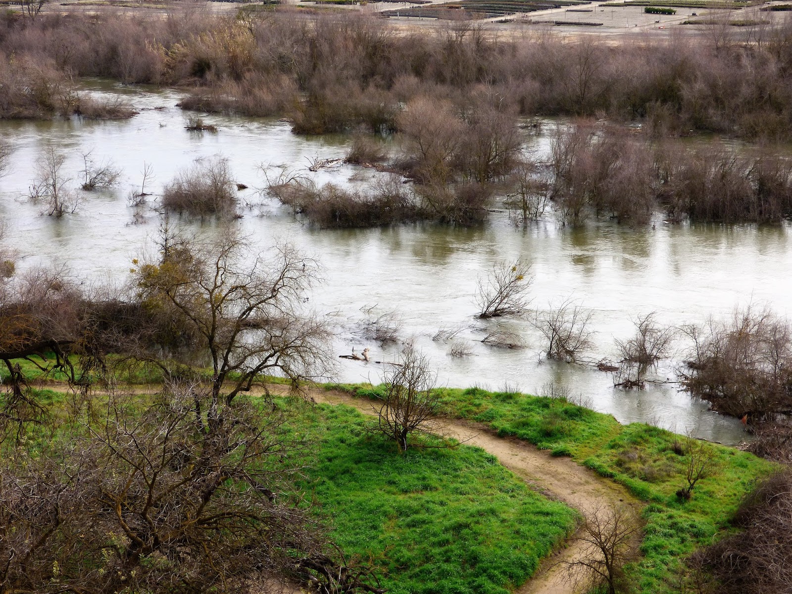
Knowing that another storm is headed in this week, I took advantage of the nice day and took a stroll along the swollen Tuolumne River. It was an amazing sight, and has been for a month now as the operators of Don Pedro Reservoir have been keeping flows at near flood level (today it the river was flowing at about 9,000 cubic feet per second). They are trying to build storage capacity in the face of continuing large storms.
The current Google image of the Tuolumne River where I walk
As I walked today, I considered how we've changed the Tuolumne River over the last 150 years, and also how the river will be changing as a result of a month of extremely high flows. There has not been a sustained flow like this in a decade or more. How will things look in a few weeks?

It's hard to say what the river looked like before the Gold Rush. Maps from that time aren't at all detailed. But we can say that the river of 1848 was certainly different than the one we see today. Most of the gravels along floodplain have been sifted and sluiced multiple times for the elusive yellow metal. In later years, from the early 1900s to as late as 1970, gold dredges processed the gravels yet again. The river gravels then were utilized as construction material, a use that continues today. However things were, the river today hardly resembles its former self.
This Google map image shows the slough that I reference below, between the S. Reinway Park and Trailhead and the pond at Frantz Wholesale Nursery. Compare to the satellite image above to see it filled with invasive River Hyacinth.

I doubt that this part of the river had the kinds of meanders found further downstream on the flatter parts of the floor of the Central Valley. It is more likely that it had somewhat of a braided pattern (multiple constantly changing channels), given the vast amount of sediment being carried from the higher parts of the Sierra Nevada. The sediment load today is diminished because of major reservoirs upstream. It would have been ideal habitat for spawning salmon.
Flows of the river are (usually) carefully controlled, not for the benefit of the stream environment, but for irrigation distribution and flood control. Intense flooding is not allowed except under the most dire of conditions such as those of 1997 when Don Pedro Dam filled unexpectedly. At that time, the peak runoff exceeded 60,000 cubic feet per second (compared to 9,000 cfs today). Had the dam not been in place, the peak runoff would have been as high as 130,000 cfs. The results of such floods in prehistoric times must have been dramatic.
The slough mentioned below is underwater on the left side of the photograph.
I imagine that change will be apparent when the present-day flood recedes in a few weeks. I'm curious as to the differences between a moderate flood that lasts for a month or more versus the floods of yesteryear when gigantic floods would occur, but last for only a few days. As I walked the banks of the river, I could see potential new channels where the river has been dry for years. I'll be revisiting the sites in these pictures to see what is new. In particular, there is a slough (an abandoned, but water-filled river channel) near the stairwell that has been stagnant for years, collecting invasive river hyacinth and garbage. A powerful current has been flushing it out, and it is possible the river may cut through and start flowing there again.
There will no doubt be other changes. Trees and shrubs have been uprooted and carried downstream, and willow thickets have been collecting debris. Gravel bars will be shifted and perhaps removed. All in all, the river may be taking the first steps towards a condition more like prehistoric times, and more conducive to the survival of salmon and other river life. We shall see.

Tuesday, April 30, 2013

Some Resources on Yosemite Valley and the Mother Lode of the Sierra Nevada

Because we all know I almost NEVER mention Yosemite or the Mother Lode on Geotripper....
It's been quite a long time since I first ventured onto the Internet, about 15 years ago. I quite clumsily put together a web page for my geology department, which included a couple of resources on the Sierra Nevada Mother Lode and Yosemite Valley. It turns out that my original web pages are due to disappear into the mists of time as the school has taken up a different web platform. If you want to see my messy first effort at a web presence, it will be around until May 6 at this site: (http://virtual.yosemite.cc.ca.us/ghayes/). Two of the pages that I thought most useful were a virtual roadside geology tour of Yosemite Valley, and a review of the Mining History and Geology of the Mother Lode.

The virtual roadside tour of Yosemite Valley has been updated and posted at Geotripper Images (see it by clicking here). I've added more than 100 photos to the tour, and noted some of the changes that have taken place in the last fifteen years since I first published the guide (a dam has been removed, and there have been a few serious rockfalls). If you are headed to Yosemite this summer, give it a look!

The Mining History and Geology of the Mother Lode (click here to see the new version) still needs work. I found out the website was slated to disappear right in the middle of the last week of school, right in the midst of a move to our new Science Community Center, and just weeks before leaving on a total of three weeks in the field, part of which involves writing a field guide for Grand Canyon, Bryce Canyon, and Zion National Parks. So I don't have too much on my plate or anything like that.

In any case the Mother Lode history needs some serious updating and I didn't have much time this week to do anything about it (I put it up in a hurry in 1998 and didn't update it all that much over the years). If you see some inaccuracies in the descriptions of mining, I'd appreciate some constructive criticism. There is plenty of history about the Gold Rush out there, but not so much in the way of geology. 

Tuesday, October 25, 2011

Depth Matters: A Tour of the Kennedy Mine Property in California's Mother Lode

We took one of our fall semester field studies trips last Saturday, to the California Mother Lode between Jackson and Columbia. It included a tour of a spectacular marble cavern (in a coming post), and the Kennedy Mine, which for a long time was one of the most important gold mines in the state.

The mine was the subject of my last post, a first impression of some of the info I learned during the tour: how people died working underground. The tour at the mine was conducted by volunteers working with the Kennedy Mine Foundation, a non-profit organization, and our guide was a fountain of information. The tour is above ground, as the mine was vertical for hundreds of feet, and flooded to boot. Our tour actually lasted 40 minutes longer than the scheduled 90 minutes, which caused me a bit of stress as I was watching the clock ticking towards the appointment time for our other scheduled tour! It was a great opportunity to see one of the most important mines of the Mother Lode.

The grounds are heavily overgrown with gray pine and oak trees, and the site is actually preserved as open space for wildlife (the wishes of the last owner of the land). This was quite a contrast to the old days; a look at old photographs indicated that the site was actually pretty barren of vegetation during the mining years.
The headframe will last a long time. It is 135 feet tall, and composed of iron beams. The original 100 foot tall wooden headframe burned (along with most of the surface developments) in 1928. Debris from the burning headframe fell down the main shaft, blocking any chance of exit for the miners still working thousands of feet below. A previous tragedy saved the men's lives: in 1922 the adjacent Argonaut Mine had burned and 47 miners died. In the aftermath, a connecting tunnel was left in place at the 4,600 foot depth between the two mines. This tunnel allowed the miners to escape unharmed.
The building in the picture at the top of this was the changing room, where miners coming off their shift could shower and change cloths before going home. It serves today as a museum and gift shop. The showers weren't really a job benefit...it allowed the mine operators to make sure no one was walking home with gold samples in their pockets! The practice, called high grading, was a constant problem for the mining companies (maybe if they paid their workers better?).
The cement monoliths above are the foundations of the main hoists for the mines. Keeping air in the mine breathable required an extensive ventilation system; carbon dioxide is a heavier gas and could often sink to the lower reaches of the mines and cause suffocation. If you remember the phrase "canary in a coal mine", it reflected a truth. Miners would carry canaries, which were more sensitive to bad air than humans. If they stopped singing, miners knew they were in danger.
Ore was hoisted to the surface of the mine, and processed in a stamp mill on the slope below the headframe. The Kennedy Mine had one of the largest stamp mills in the entire Mother Lode, with 100 stamps. Each stamp weighed nearly half a ton, and they were in constant motion, vertical hammers rising and falling, crushing the ore into a sand-like consistency. Mercury and other "benign" chemicals were used to separate the gold from the waste material. Mercury combines with gold to form a solid alloy called amalgam.

The mine waste was a problem. It was full of sulfide minerals that converted to acids on exposure to the atmosphere, and water in the town below was being fouled. In the early 1900s, a system of buckets and giant wheels was constructed to carry tailings over a nearby ridge to a reservoir that could isolate the poisons from the domestic water supply (you can see pictures of the wheels here).
 The monstrous piece of metal in the picture below was a camshaft that was used to lift the stamps.
The mine office is the best preserved building on the mine property. It was built in 1908, and was one of the only buildings to survive the 1928 fire. It included some contradictory operations, although they make a certain amount of sense when one thinks about it. There were two big blast furnaces, one for separating the gold from the mercury, and the second for melting the gold and producing ingots for delivery to the mint in San Francisco. I have to imagine that the whole building must have been terribly hot in summertime (temps in the Mother Lode often exceed 100 degrees). The other side of the ground floor was the assay office, which tested ores at the end of every day, so the quality of ore was always known.
The second floor contained mine offices, the safe, and the pay room. Miners made around $4 a day in the 1920s, and specialists (foremen, carpenter, assayers, and blacksmiths made almost twice as much). These were fairly reasonable wages for the time.
The third floor contained four bedrooms of all things. They were there to house investors when they paid a visit to the mine. They mostly lived in San Francisco and the journey could be long and dusty.
The view from the mine office building is quite nice, overlooking the town of Jackson, and the eroded volcanic neck of Jackson Butte, seen in the picture above.

The Kennedy Mine operated unsuccessfully from 1860 to the late 1870s. New technology (especially the invention of dynamite and steam operated drills) led to a successful expansion of the mine in the 1880s, and the Kennedy operated profitably until 1942 when it is shut down by presidential decree during World War II. When it closed down it was the deepest mine in the United States at 5,912 feet. It ultimately produced about 1.5 million ounces of gold, worth about $2.4 billion at today's prices. It was one of the biggest gold producers in the Mother Lode.

Thursday, March 17, 2011

A Day in the Field...Doing Geology in the Mother Lode

The state flower growing in the state rock next to a site where the state mineral was being mined...the only thing missing was the state mammal, and it's been missing for 80 years. On second thought, I would prefer not to have run into our state mammal anyway. It's the California grizzly, after all. I am talking about an early spring arrival California poppy growing in an exposure of serpentine along a fault in California's Mother Lode where gold was being mined from the 1850's through the 1930's. I was in the field last Saturday!

It's been an emotionally tough week. The sorrow and grief over the earthquake and tsunami in Japan, compounded by the ongoing meltdown at the Fukushima nuclear power plant has been bearing down on most of us. We face draconian budget cuts in our state educational system, and friends and fellow workers received layoff notices this week. Science is under attack at a time when it needs to be upheld as a way of working through serious and profound problems that face society in agriculture, energy and climate change. But the right questions aren't even being asked or discussed.

I have felt despair in so many ways. But like I said, I was in the field last Saturday, and I learned something. Teachers may think of their role as trying to inspire their students, but sometimes it's the other way around. The thirty students inspired me as they discovered some new things about their world. I wasn't dragging them around; they were pulling me...

We were exploring the southern Mother Lode between the Gold Rush towns of Mariposa and Jamestown, and learned how the gold was mined, how it formed, and a bit about the environmental devastation the mining caused. We got to collect the gold ore, quartz crystals, a rare chromium mica called mariposite, and pyrite. We also had a nice view up the Merced River towards Yosemite Valley! El Capitan is the steep cliff on the left, the tip of Half Dome appears just left of center, and Clouds Rest is the snowy peak behind El Cap.

We started at the dredge tailings around Snelling and Merced Falls. To get at microscopic bits of gold that had been carried down the rivers into the Central Valley, the mining companies dug holes down to the groundwater table, forming ponds in which they floated a factory ship that dug out one end of the pond, processed the sediments for gold, and dumped the waste on the other end. They worked their way across the landscape, ripping up the topsoil and leaving behind square miles of rockpiles. The land is mostly useless now, but it provided us an opportunity to identify the kinds of rocks that occur upstream, and which reveal something of Sierran history. There was quartzite (baked and pressurized beach sands), metavolcanic greenstone, slate, and occasional fragments of marble and granite. Three quarters of the rocks found in the Sierra are various types of granitic rock, but in the Mother Lode, the more ancient and more common metamorphic rocks tell a story of ancient shorelines, terrane collisions, volcanism and other activity. These rocks are far older than the granitic intrusions.
Later in the day we explored an abandoned gold mine (just the outside, mind you) where we found the most interesting minerals, and found the famous outcrop just west of Coulterville where we could see the minerals and rocks in their original arrangement. This stretch of the Mother Lode was relatively barren of gold, so the outcrop was not mined like so many others.
It was nice to see them discussing and exploring the outcrop! That doesn't always happen.
Our day included a stop at the California State Mining and Mineral Museum in Mariposa, where a great many spectacular specimens are on display. I photograph a different group of minerals every time I visit, and somehow I concentrated on the gold this time. The leafy gold above is a piece of a larger 44 lb nugget discovered at the Harvard Open Pit Mine just before it closed down in the 1990's (the big nugget is on display at the Ironstone Winery in Murphys, a bit farther north just off of Highway 49. Below is the Fricot Nugget, weighing in at 13 lbs. It's the biggest specimen on display, and one of the largest to survive the Gold Rush era without being melted down. If you are curious, the largest single specimen ever found in the state weighed just short of 200 lbs. It got melted down, but a replica is on display in the museum.
Strangely enough, the specimen I found most interesting was one of the smallest. We tend think of gold as nuggets that have been rolled in a stream and rounded off. We don't often think of gold crystals, but there it is below. Gold crystallizes in the isometric (cubic) system, but not generally as square cubes. The specimen below looks to be more like a dodecahedron.
Across from the mine site we took a brief excursion into the Earth's mantle, which is normally found many miles below the crust, but which been pushed up to the surface along a major fault system. Most of the mantle rock (peridotite)has been altered to serpentine, but we could find some chunks of mostly unaltered mantle material.

We ended the day with stops to look at the abandoned Harvard Open Pit Mine that operated in the 1980's and 1990's, and at Table Mountain near Jamestown, a famous example of an inverted stream. I may have more to say about it next week, since our geology club is intending to climb it this weekend (in the rain, probably).

All in all it was a good day, a brief respite from sorrow, and a day of being inspired by the enthusiasm of some great students.

Saturday, July 31, 2010

The Other California: The CA State Mineral Museum - this is art, darnit!

I know it when I see it. Purveyors of that which we would not call art would use shiny perfect minerals that would cause the viewer to objectify the image, and desire to possess it without appreciating or respecting the intrinsic value and quality of the mineral. I would never stoop that low just to get readership here at Geotripper. Just ignore the "xxx" and "big gold nuggets" in the blog tags. Besides, these things are in a museum. That makes this art, darnit!
And what a great museum it is! One would think that the official state mineral collection would be housed in the state capitol somewhere, or in San Francisco or Los Angeles. The collection actually was in San Francisco for many years, surviving the 1906 earthquake, but in 1983 the collection was moved to Mariposa in the Sierra Nevada Mother Lode, where it resides in the California State Mining and Mineral Museum, a unit of the state park system. The choice of Mariposa makes a certain amount of historical sense, as the town hosted one of the very first hardrock mines and mills during the Gold Rush, the Mariposa, discovered by Kit Carson and ultimately owned by John C. Fremont, two of the big players in early state history.

One of the premier attractions of the collection is the Fricot nugget (that's a part of it at the top of the page), the largest single remaining nugget from the Gold Rush days, at 13.8 pounds. It sits in a vault within a vault. Most large nuggets were simply melted down (there is a larger nugget at the Ironstone Winery, but it was found in the 1990's at the Harvard Mine). There is a facsimile of the biggest nugget ever found, which originally weighed in at around 200 pounds.

The other smaller gold sample shown above is extraordinary as it shows the crystalline nature of the metal. The mineral forms octahedral crystals, but they aren't seen often because the malleable metal gets pounded into the more familiar nugget shape while being rolled in a stream. Samples like this one have to come from the quartz veins in mines.

The museum has a spectacular collection of other minerals, including some of the best specimens of our state gemstone benitoite. This exceedingly rare sapphire-like crystal is found at a single locality in the world, a serpentine outcrop in the Coast Ranges of San Benito County.

The museum has a host of other minerals on display, like the malachite sample above, and the aquamarine sample below. There are some excellent interpretive exhibits regarding the history and current state of mining in California, and even a 175 foot long tunnel that recreates a gold mine.
Admission is $4.00, but they offer discounts for school field trips (call in advance). The staff and volunteers are knowledgeable and helpful. The museum is located on Highway 49 just south of the town of Mariposa at the county fairgrounds. Unfortunately, the museum has been one of the pawns in the state budget wars, and has been threatened with closure off and on. It could use some friends in the capitol...

The Other California is part of my continuing explorations of the California that you don't always find on the postcards.