"Why?", indeed. I have to admit that I get just a little tiny bit elitist at times, at least in my approach to visiting my favorite national park, Yosemite (program note: my "favorite national park" is likely to change on a nearly daily basis, depending on whichever one I happen to have visited most recently). I tend to emphasize the spots far from the madding crowd, and wow, does Yosemite get crowds. Last year included a huge spike in visitation, to five million people (the park has only exceeded four million twice). Lines at the entrance stations, lines at the parking areas, gridlock on the valley roads. If one arrives at the wrong time of year and the wrong time of day, one may be quite stuck and not see very much.
So what to say to the hapless traveler who waited for an hour or two at the entrance station, and circled the parking lots waiting for someone to leave, got into a shouting match with the person who tried to grab their spot, and finally has a chance to see things? Obviously, I am saying "go see more"! It's not enough to just see the rock cliffs from the bottom. Go to Glacier Point and get an entirely different perspective on things. I have a feeling that someone like that will not be willing to give up their coveted spot, and their time for visiting may be short anyway. And Glacier Point has a pretty good chance of being socked in as far as parking, too. The main lesson? Don't visit during the height of summer.
Still, there is nothing quite like seeing Yosemite Valley from above, especially from a cliff that is a sheer 3,200 foot drop straight down. It's dizzying, and exhilarating, and vertigo-inducing (that's about the same as dizzying, but only a thesaurus can describe a view like this). If you ever have the slightest chance of getting up there, go for it without hesitation (and while up there, don't miss Washburn Point or Taft Point).
My memories of Glacier Point go back quite a ways. I was here with my family around 1966 or 1967 when we watched the Firefall from the valley floor. This used to happen as the workers for the Curry Company pushed a bonfire over the brink.The embers glowed bright as they fell for several thousand feet, and it became a nightly tradition. A day or two later we were on the rim at Glacier Point where I could watch them push the fire off the cliff. It was interesting, but over the years the spectacle caused traffic congestion in the valley, and was not in keeping with the natural environment. The practice was ended in 1968. In an interesting twist, a fire fall happened naturally in the valley in 2008. A marvelous picture was captured by Edith Howe-Byrne, a photographer who spends part of the year in the valley. Check it out here.
Glacier Point is perched on a cliff-top at the upper end of Yosemite Valley across from Half Dome. The view includes Yosemite Falls and the valley floor to the north (above), the glacial U-shaped valley of Tenaya Creek at the base of Half Dome (below), and the alpine country to the east.
The Overhanging Rock at Glacier Point has been an iconic picture spot for a century or more. I can hardly estimate how many people have stood on, danced on, done handstands on, or pretended to be falling off of. It's outside the fencing, and thus technically off-limits, but without a ranger present people can't resist the tempting of fate. To be sure, I've stood on many a precarious rock in my day, but I have a serious problem with people who do so in such a crowded place. There's a certain peer-pressure (peer-comfort?) in seeing someone else standing in such a place leading to the thought, "if they can do it, I can do it too". Eventually you get someone who unexpectedly gets vertigo or faints. I don't know how many have fallen, but there have been a few. I cringed the other day as first one person went out, and then others climbed the fence and got their pictures too.
I much prefer letting the rock be part of the scenery, a nice bit of foreground for shots of the distant cliffs. I admit to taking great pains to make sure there are no signs of walls or fencing or people in my shots from the point. I like to imagine I'm the only person perched on this solitary cliff so far and distant from the hubbub below (and all around me).
The day had been unexpectedly cloudy, and the rocks across the valley lost a bit of definition in the gloom, but shortly before we decided to leave, the sun broke through and the granite began to glow. The contrast of shadow and rock was striking.
This might be one of my favorite shots of Half Dome, with both the foreground and background bathed in shadow.
Glacier Point is accessed by Glacier Point Road, which is about a 22 mile drive from the valley floor (allow an hour to get there). The road is paved, but narrow and windy, and filled with the most dangerous animal in the park, the scared flatland driver. There is a large parking lot, pit toilets, and a modest curio/snack shop open seasonally. The walk to the view point is perhaps a quarter mile, maybe less, and is fully paved, and partly accessible for wheelchairs (mainly the upper viewpoint). A number of trails start from the point as well.
Wednesday, November 8, 2017
Sunday, November 5, 2017
Looking Down on Yosemite: A Return to Taft Point
I don't know how it happened, but somehow 12 years slipped by since I last made the hike out to Taft Point above the floor of Yosemite Valley. It's not that tough of a hike, only 1.1 miles with just a bit of climbing on the way back. But what a payoff at the end. There is nothing quite like standing on the brink of the ultimate abyss.
The trail begins at a parking lot about two miles up the road from Glacier Point. Parking is limited and fills quickly, so be sure to arrive early in the day, or you'll be walking a lot farther from your parking spot. Or you can do what I did and wait until about the last day of the season before a major snowstorm, and come at the end of the day when the sun is quickly sinking below the horizon.
The beginning of the trail in the deep Red Fir forest gives few hints of the grandeur that lies beyond. It almost immediately passes an unusual outcrop of almost pure quartz (remember y'all, it's a national park; no collecting!). The trail plunges into the forest and crosses Sentinel Creek, which a short distance downstream falls over the brink of Sentinel Falls, more than 1,000 feet high.
The trail breaks into the open, and one can sense the edge of nothingness that lies beyond. And then there's a distraction! There are huge open cracks near the cliff edge that split the rock for hundreds of feet. These are called the Taft Fissures, and they are a bit of evidence for the geology that led to the formation Yosemite Valley itself. The fissures follow distinct cracks in the granitic rock that makes up the cliffs in this area.
Granite forms miles below the surface as molten magma within the crust cools slowly, forming a coarsely crystalline rock. The rocks are under tremendous pressure from the overlying rock, but over time the rocks are uplifted and erosion strips away the "overburden". As the rocks approach the surface, they expand in volume, but being solid, they crack to form joints. On the scale of Yosemite Valley, the joints were points of weakness that could be exploited by flowing glaciers to carve and cut away at the cliffs. Many of the sheer cliffs of Yosemite are joint surfaces. Unfortunately, many rockfalls begin with joints that give way along the vertical cliffs.
At Taft Fissures, the joints allowed water and ice to get into the interior of the rocks, causing the minerals on the surface of the rock to crumble to quartz gravel and clay dust. As the cracks widened, boulders would occasionally fall in and become wedged inside, as seen in the picture above.
Just beyond the fissures, the world ends...the cliff edge is the beginning of a sheer 3,000 foot drop to the valley floor below. The perspective is both stunning and dizzying. It's hard to believe, but the viewpoint makes El Capitan look almost...small. It's scattered in with so many other steep cliffs.
The fast-setting sun illuminated the cliff of El Capitan and the scar of the September rockfall from the cliff at Horsetail Fall. The first view in the picture above is not actually Taft Point. The point is on the upper left. I would have to head up there to get the entire view.
There are four stunning viewpoints within a short walk of Glacier Point Road. Washburn Point, seen in the last post, emphasizes the wilderness lands upstream of Yosemite Valley (and a side view of Half Dome). Glacier Point provides a look straight down into the upper end of the valley, extending from Half Dome and Tenaya Creek Canyon to the area around Yosemite Falls. Sentinel Dome provides a 360 degree panorama of the entire region, but without the dizzying look straight down sheer cliffs. It is accessed from the same trailhead as Taft Point.
Taft Point picks up the view of the valley floor at Yosemite Falls and provides a panorama of the western parts of the Yosemite Valley, taking in the Three Brothers, El Capitan, and the Cathedral Rocks which soar above Bridalveil Falls (which are hidden on the far side). The sweeping view also takes in the western slope of the Sierra Nevada, leading down to the Mother Lode foothills and the Great Valley beyond.
Although the rockfall at Horsetail Falls in September has garnered all the news these last few weeks, the view from Taft Point takes in a perspective on the largest historic slide in the valley, which happened in 1987. An estimated 600,000 cubic meters of rock came down the cliff of Middle Brother (on the right side of the picture above). Luckily, no one was hurt as the Park Service had shut down the road when loud sounds of fracturing rock were reported coming from the cliffs above. The September rockfall, in contrast, was a bit over 10,000 cubic meters.
The cliff of El Capitan and the sheer cliffs of the Cathedral Rocks form a constriction in the western part of Yosemite Valley. Sometimes called the "Gateway", the rocks stand out because they are relatively unjointed, and thus were more resistant to the cutting and quarrying action of the glacial ice. The barrier even extends underground. Beneath the cliffs, the sediments are only about 300 feet deep. Farther up the valley, the sediments are around 2,000 feet deep. The glaciers at times had to flow up and over the sill of granite.
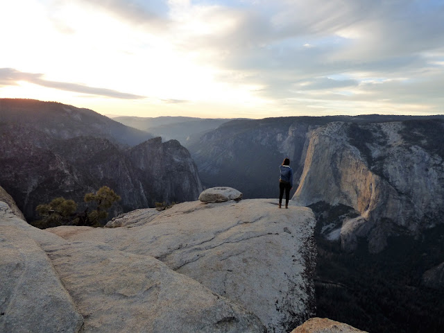
Taft Point is an amazing place. If you have a fear of heights, this will be a good place to either cure it forever, or amplify the condition to the point that you will be a whimpering mass of a nervous wreck. I don't mind looking over the edges of cliffs myself, although it will sometimes be on my belly. One never knows when one might have a fainting spell, after all. But I cannot watch others standing on cliff edges, especially if they are my students. I tell them to do their antics on their own time.
The sun hit the horizon and the sky exploded into flaming orange and pink. I quickly headed up the trail and back to the car so Mrs. Geotripper and I could have a nice dinner back down on the valley floor. It didn't matter that it was dark. The moon was up and we could still see the cliffs above, including a constellation of lights from at least fourteen climbing parties on El Capitan.
The trail begins at a parking lot about two miles up the road from Glacier Point. Parking is limited and fills quickly, so be sure to arrive early in the day, or you'll be walking a lot farther from your parking spot. Or you can do what I did and wait until about the last day of the season before a major snowstorm, and come at the end of the day when the sun is quickly sinking below the horizon.
The beginning of the trail in the deep Red Fir forest gives few hints of the grandeur that lies beyond. It almost immediately passes an unusual outcrop of almost pure quartz (remember y'all, it's a national park; no collecting!). The trail plunges into the forest and crosses Sentinel Creek, which a short distance downstream falls over the brink of Sentinel Falls, more than 1,000 feet high.
The trail breaks into the open, and one can sense the edge of nothingness that lies beyond. And then there's a distraction! There are huge open cracks near the cliff edge that split the rock for hundreds of feet. These are called the Taft Fissures, and they are a bit of evidence for the geology that led to the formation Yosemite Valley itself. The fissures follow distinct cracks in the granitic rock that makes up the cliffs in this area.
| One of the Taft Fissures. The "layers" are exfoliation fractures, a process related to jointing. |
At Taft Fissures, the joints allowed water and ice to get into the interior of the rocks, causing the minerals on the surface of the rock to crumble to quartz gravel and clay dust. As the cracks widened, boulders would occasionally fall in and become wedged inside, as seen in the picture above.
Just beyond the fissures, the world ends...the cliff edge is the beginning of a sheer 3,000 foot drop to the valley floor below. The perspective is both stunning and dizzying. It's hard to believe, but the viewpoint makes El Capitan look almost...small. It's scattered in with so many other steep cliffs.
The fast-setting sun illuminated the cliff of El Capitan and the scar of the September rockfall from the cliff at Horsetail Fall. The first view in the picture above is not actually Taft Point. The point is on the upper left. I would have to head up there to get the entire view.
There are four stunning viewpoints within a short walk of Glacier Point Road. Washburn Point, seen in the last post, emphasizes the wilderness lands upstream of Yosemite Valley (and a side view of Half Dome). Glacier Point provides a look straight down into the upper end of the valley, extending from Half Dome and Tenaya Creek Canyon to the area around Yosemite Falls. Sentinel Dome provides a 360 degree panorama of the entire region, but without the dizzying look straight down sheer cliffs. It is accessed from the same trailhead as Taft Point.
Although the rockfall at Horsetail Falls in September has garnered all the news these last few weeks, the view from Taft Point takes in a perspective on the largest historic slide in the valley, which happened in 1987. An estimated 600,000 cubic meters of rock came down the cliff of Middle Brother (on the right side of the picture above). Luckily, no one was hurt as the Park Service had shut down the road when loud sounds of fracturing rock were reported coming from the cliffs above. The September rockfall, in contrast, was a bit over 10,000 cubic meters.
The cliff of El Capitan and the sheer cliffs of the Cathedral Rocks form a constriction in the western part of Yosemite Valley. Sometimes called the "Gateway", the rocks stand out because they are relatively unjointed, and thus were more resistant to the cutting and quarrying action of the glacial ice. The barrier even extends underground. Beneath the cliffs, the sediments are only about 300 feet deep. Farther up the valley, the sediments are around 2,000 feet deep. The glaciers at times had to flow up and over the sill of granite.
Taft Point is an amazing place. If you have a fear of heights, this will be a good place to either cure it forever, or amplify the condition to the point that you will be a whimpering mass of a nervous wreck. I don't mind looking over the edges of cliffs myself, although it will sometimes be on my belly. One never knows when one might have a fainting spell, after all. But I cannot watch others standing on cliff edges, especially if they are my students. I tell them to do their antics on their own time.
The sun hit the horizon and the sky exploded into flaming orange and pink. I quickly headed up the trail and back to the car so Mrs. Geotripper and I could have a nice dinner back down on the valley floor. It didn't matter that it was dark. The moon was up and we could still see the cliffs above, including a constellation of lights from at least fourteen climbing parties on El Capitan.
Friday, November 3, 2017
Perhaps a Last Look at Some Yosemite High Country (for the Winter, Anyway)
| "Half" Dome from Washburn Point |
| Yosemite high country, with Mt. Broderick, Liberty Cap, and Nevada Fall in the foreground. |
| Nevada Fall on the upper Merced River |
| Vernal Fall from Washburn Point |
| North Dome and Basket Dome on the north side of Yosemite Valley. Mt. Hoffman rises in the distance. |
Tuesday, October 31, 2017
Finding Peace in the Nation's Most Crowded Park: A Walk Through Yosemite Valley
If you've read my previous couple of posts, you know I was in Yosemite Valley over the weekend. I was guiding my students on a field trip up the Merced River and into the park on Saturday, and I came back on Sunday seeking some better pictures of the recent rockfall at El Capitan.
We can't park a big bus just anywhere on the floor of Yosemite Valley, so I had to let my students loose to find their way to the upper end of the valley using the free trams. There was enough time that I decided to walk the three or so miles from Yosemite Lodge to Happy Isles, picking whatever winding combination of roads, trails, or sandy river shoreline I could find (there's a direct route, but why stick to that?). I was almost immediately awarded with a nice view of Yosemite Falls, which at 2,425 feet is about the seventh highest waterfall in the world. To my surprise, there was a bit of water flowing, kind of unusual this late in the fall.
The fall colors may not match the technicolor splendor that happens in the hardwood forests of the eastern U.S., but then those forests don't have the backdrop of vertical granite walls that Yosemite has. I was reveling in the splash of color here and there. I often think that fall is my favorite time of year here.
I made my way across the meadow trail to Sentinel Bridge. The cliffs of Glacier Point loomed high above. I didn't realize that I'd be up there looking down the very next day (that will be another post).
Half Dome seems to loom over every meadow view in the valley. It rises 4,800 feet above the valley floor. Although glacial ice filled the valley to the rim, Half Dome stood above the frozen rivers. It was shaped by exfoliation sheeting (corners and edges snapping off), as well as a bit of undercutting from the glaciers below. As you will see in a near future post, Half Dome would better be called Four-fifths Dome, but that doesn't flow so well. Actually I prefer the Native American name of Tis-sa-ack ("Crying Girl").
Because people tend to stare at Yosemite Falls when they are flowing, they find it easy to miss the prominent cliff of Yosemite Point and the Castle Cliffs (below).
I crossed the Merced River at Sentinel Bridge, and got a colorful version of the iconic view of Tis-sa-ack reflected in the still water.
It's the funniest thing...the seven square miles of the floor of Yosemite Valley may very well be the most crowded real estate in the national park system. The park doesn't get the highest number of visitors in the system, but it does get five million, and something like 90% of them spend their visit in the valley. And yet, despite the crowds on the day I was there, the moment I got off the road, I invariably found myself alone. Finding peace in the middle of tourist chaos is a precious gift, and I soaked it in.
Approaching the footbridge near the empty Curry Housekeeping Camp, I had a fine view towards Yosemite Point and the Castle Cliffs reflected on the Merced River.
I quickly walked through the gaggle of people at the stores in Curry Village (I'm not a purist; I stopped for a Gatorade at the store). I headed up the trail to Happy Isles. I started to find more and more Dogwood trees turning shades of pink and yellow. I made it to the Nature Center and met with my students to talk about geology, and then we made our way back to Yosemite Lodge.
While I was talking to the students one last time, I happened to turn and saw the Moon rising along the cliffs off to the southeast. I snapped some zoomed pictures, only to find later that I was aiming directly at Glacier Point. If you look closely, you can see the fencing and people gathered on the edge of the precipice. I was pleased with the effect.
We got on the bus and headed home, and despite the hubbub of running around with students all day, it was one of the most serene experiences I've had in a while. And best of all, I would be up there again the next day!
Monday, October 30, 2017
El Capitan Rockfall: Alternate Views, and a Realization That This Wasn't the First TIme
| El Capitan and the September rockfall from Taft Point on Oct. 29, 2017 |
| September rockfall from Taft Point on Oct. 29, 2017 |
The view is striking. The rocks let loose from well over a thousand feet over the valley floor. According to Greg Stock, geologist for Yosemite National Park, the biggest slab (out of seven total), was 394 feet long, 148 feet wide, and between 8 and 28 feet thick. That's bigger than a football field. It had a volume of 10,250 cubic meters, and weighed about 27,675 metric tons. If these numbers and dimensions seem incredibly exact, there's a reason. As Greg Stock explains, in an informative research paper, the walls have been mapped in three dimensions by a form of radar (lidar), and in the aftermath of the rockfall, the walls at the site of the fall were mapped again. The difference in volume could then be calculated.
![]() |
| El Capitan from Taft Point in 2005 |
I was at Taft Point in 2005, taking pictures of course, and one can compare the appearance of the cliff prior to the event in September.
| Horsetail Falls area and future site of rockfall in 2005 |
| The Horsetail Falls cliff on Oct. 29, 2017 |
| The cliff near Horsetail Falls in 2016 |
| El Capitan and the Horsetail Falls cliff on October 30, 2017 |
As I was going through my old pictures, I came to realize that slides have come off this particular cliff in the past. I actually witnessed one of them in 2010 when I was lounging on the granite near the top of Sentinel Dome across the valley. When I say "witnessed" I mean I heard the commotion first, took a moment to realize what I was hearing, jumped up, scanned up and down the valley, and finally thought to turn on the camera and take a few pictures of the rising dust plume.
![]() |
| Dust plume from the 2010 rockfall east of El Capitan |
Subscribe to:
Posts (Atom)


