Showing posts with label Mt. Hoffman. Show all posts

Friday, November 3, 2017

Perhaps a Last Look at Some Yosemite High Country (for the Winter, Anyway)

"Half" Dome from Washburn Point
I made the trek up the hill to see Yosemite last weekend, with a field trip on the valley floor on Saturday with my students, and a quieter tour in the high country with Mrs. Geotripper on Sunday. We headed up Glacier Point Road to gain a unique perspective on Yosemite Valley and the higher country above. With a fairly powerful storm arriving tonight, it is at least conceivable that the road could close for the winter due to snow. There was certainly a mood of closing down. The road was uncrowded, and so were the parking lots. The curio shop at Glacier Point was closed for the season.
Yosemite high country, with Mt. Broderick, Liberty Cap, and Nevada Fall in the foreground.
Many people who travel to Glacier Point tend to be single-minded in their quest, and often miss one of the truly spectacular viewpoints the road has to offer: Washburn Point. It is perched at the 7,400 foot level above the Merced River directly across from "Half" Dome. It is from this point that the misnomer is most obvious. If anything, Half Dome should have been named "Four-fifths Dome".
Nevada Fall on the upper Merced River
There is a stupendous view towards the high country of Little Yosemite Valley and the headwaters of the Merced River. The effect of glaciation is apparent everywhere. Glacial stairsteps, caused by pervasive vertical fractures in the granite ("joints"), were the origin of the two major waterfalls on the Merced River, Nevada Fall (594 feet, above), and Vernal Fall (317 feet, below). Along the skyline above, the glacially-carved horns, aretes, and cirques can be seen. It's wild and beautiful country.
Vernal Fall from Washburn Point
I imagine Washburn Point gets less traffic than Glacier Point because it doesn't look down on the main part of Yosemite Valley. That's okay with me. It's notable that not a single road is visible from Washburn. One is looking at wilderness, something that is sorely lacking in the more populated parts of Yosemite National Park.
North Dome and Basket Dome on the north side of Yosemite Valley. Mt. Hoffman rises in the distance.

Tuesday, February 2, 2016

Time for the Topographer's Challenge! What Peak is this in Yosemite National Park?

Actually, I want your help here. I don't know the peak with the vertical flank on the right side of the picture above. I took this shot yesterday from near the intersection of Wellsford and Milnes Roads between Modesto and Waterford. I was looking east or just north of east when I got the shot.

The thing is this. There's an intense discussion on a facebook post (see it here), with some strong opinions that it is Half Dome. I don't think it is, because I've photographed Half Dome from the valley on a number of occasions (here, here and here), and it just doesn't have this kind of topographic prominence from the peaks that surround it. I also can't related to the peaks that should be around it, like Clouds Rest, and Sentinel Dome.

But I'm left with this. If it isn't Half Dome, what peak is it? I think it's north of Yosemite Valley, and I think that the white peak on the far left of the first picture above is Mt. Conness. Could it be Mt. Hoffman? Anyway, your expert guidance and half-formed opinions are equally welcome!

Friday, June 18, 2010

Half Dome is down to a Quarter! Will Anyone Want to Visit Yosemite?

OK, not really, I'm just continuing a brief series on Yosemite Valley encouraging folks to look behind and to the side of the iconic features like Half Dome, El Capitan, Yosemite Falls and Bridalveil Fall. Our "high-water journey" to Yosemite Valley last week included an excursion to Glacier Point, which had opened to visitors only a few days prior.

The views from Glacier Point, and the usually quieter Washburn Point, were spectacular, as they almost always are. Half Dome dominates the views, so I was trying to take a few shots that didn't have the granite monolith in the center. They appear below.

I am always struck by the grandeur of Tenaya Canyon, the main tributary valley to the Merced River that meets the Merced at the head of Yosemite Valley. I call it a tributary "valley" because Tenaya Creek is a relatively underfit stream, quite incapable of carving such a deep valley, one that rivals the Grand Canyon in depth.

Even the glaciers shouldn't have been big enough to carve such an impressive gorge, and they wouldn't have except that the vast ice sheet that covered the Tuolumne Meadows area to the north spilled over and contributed a vast amount of ice to the otherwise small Tenaya glacier system.
It was a week of the highest snow runoff, with the Merced River running at 7,000 cubic feet per second, about three times normal. So with a zoom shot, I was able to spy the rarely viewed Pywiack Cascades, in a trailless and inaccessible part of Tenaya Creek Canyon (an interesting description of the high adventure journey through this gorge can be found here). I would love to make that journey, but I'm getting just a bit old for such ventures!

If Half Dome didn't exist, North Dome and Basket Dome would certainly command more attention. Unlike Half Dome, these lower domes were probably covered by ice during the most intense glaciations, but in the last 800,000 years most of the shaping has been accomplished by exfoliation. Exfoliation is a form of unloading, in which the granite expands as it is exposed by erosion, cracking into slabs running parallel to the surface of the rock. The slabbing tends to break off corners and edges, leading to the characteristic dome shape.

The view from Glacier Point changed forever in March of 2009 when a huge rockfall, the biggest in two decades, thundered off of Ahwiyah Point below the cliffs of Half Dome. The light colored strip running across the photo above shows the path of the slab, and the pile of talus in the shadow shows the impact point. Hundreds of trees were blown down, and a popular hiking trail was covered, but luckily no one was hurt.

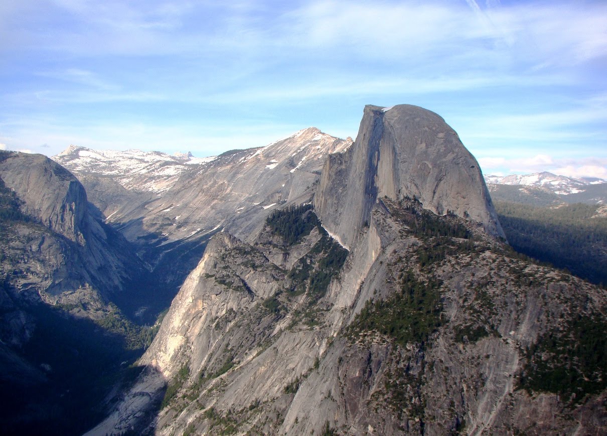
I know it is hard to see the view from Glacier and Washburn without actually noticing Half Dome, and so I did take quite a few pictures of it. One of them is below, if you are feeling only half-satisfied by the rest of the post!