Showing posts sorted by relevance for query Ahwiyah Point. Sort by date Show all posts

Friday, October 9, 2009

Under the Volcano and Into the Abyss: Yosemite National Park


Yosemite National Park is the oldest "national" park in the United States, having been established by Congress and Abraham Lincoln in the midst of the Civil War as a protected reserve deeded to California. It became an official national park in 1890, third after Yellowstone and Sequoia. I did a short blog series (boog? bleeries?) on some of the less familiar sights that one-time visitors might miss if they spend all their time looking at Yosemite Falls or Half Dome. I recalled the series while discussing America's relationship to the national park system in the aftermath of the wonderful Ken Burns documentary "The National Parks: America's Greatest Idea". I have them (semi) organized below in the order that they appeared. I've also included a flurry of posts on some of the rock falls in the last year. If you are ever headed out to Yosemite, check out the NAGT geologic road guide to Yosemite Valley and the western Sierra foothills (the extended wood-pulp version can be ordered here).

Photo of the Day - Feeling Crushed? : this series started far from Yosemite, but rocks in the Coast Ranges are very much part of the story. Sierra granites originate from subduction of crust and subsequent melting of these rocks to form magma. We take a drive into the crust that would make Ms. Frizzle jealous

Journey to the Center of the Earth (well, the mantle at least) A brief look at chrome and mercury mining in the Coast Ranges, in the subduction zone rocks

Continuing Journey in the Earth - Taking the Time Machine When granites were forming under the future Sierra Nevada, dinosaurs and sea-going reptiles prowled the ancient land surfaces

Standing Underneath Volcanoes We arrive at Yosemite Valley and I describe the familiar scene from the Tunnel View, and explain the odd title

Touring the Underside of the Volcanoes, Part 2 How easy is it to visit the underside of a volcano? We find out, and what enclaves are in this post

Under the Volcano: Changing the Emphasis Taking a closer look at the Cathedral Rocks and the El Capitan granite that forms the impressive cliffs

Under the Volcano: Changing the Emphasis -Part 2 Another less familiar cliff is Sentinel Rock (see the second picture above), and the Sentinel granodiorite of which it is composed

Under the Volcano: Changing the Emphasis -Part 3 One of the unknown waterfalls in Yosemite is the rarely seen Sentinel Falls, on the south side of the valley across from Yosemite Falls

Exploring Yosemite, continued and the Rock of the Day A brief foray west of the park on a beautiful spring day, and a look at some of the older metamorphic rocks

Under the Volcano: Changing the Emphasis -Part 4 Who's heard of Lehamite Falls? Many park visitors ignore them, for they are overshadowed by nearby Yosemite Falls

Yosemite Falls: The Spectacle that Almost Wasn't Yosemite Falls are actually an aberration! They were once far more like Lehamite Falls in the previous post...I explain why

Under the Volcano: Changing the Emphasis -Part 5 A look at the Lost Arrow

Under the Volcano: Changing the Emphasis -Part 6 The highest unbroken waterfall in Yosemite is not named Yosemite! I describe it in this post

Under the Volcano: Changing the Emphasis -Part 7 Another little-known fall, the Royal Arch Cascades, behind the Ahwahnee Lodge

Under the Volcano: Changing the Emphasis -Part 8 Silver Strand Falls, another unknown waterfall

Under the Volcano: Changing the Emphasis -Part 9 Sometimes the familiar sights become transformed by different timing. Yosemite Falls at night, one of the few times we ever had the valley to ourselves

Staring into the Abyss - Yosemite as you (maybe) have never seen it We leave the valley floor and take in the view from the edge of the abyss at Taft Point

Staring into the Abyss #2 - Yosemite as you (maybe) have never seen it The Three Brothers from the rim, and Yosemite's largest historically recorded rockfall

Staring into the Abyss #3 - Yosemite as you (maybe) have never seen it Looking west from Taft Point towards the Cathedral Rocks, and what happened to Yosemite's meadows?

Staring into the Abyss #4 - Yosemite as you (maybe) have never seen it (and my 100th Post!) There are many domes in the vicinity of Yosemite Valley, and most did not form because of glaciation. A discussion of North Dome and Basket Dome, from Glacier Point

Staring up out of the Abyss: Check out this fire in Yosemite I link to one of the most extraordinary pictures I've ever seen of Yosemite. A fire was burning on the north rim, dropping embers into the valley. Spectacular!

Staring into the Abyss #5 - Yosemite as you (maybe) have never seen it Nevada and Vernal Falls from the Glacier Point area

Taking the High Ground: Yosemite as you (maybe) haven't seen it Climbing Sentinel Dome. A bit shorter than Half Dome, and a lot easier to climb!

Revisiting Yosemite Several weeks passed, and I made a few last posts before embarking on my journey through the Colorado Plateau. Yosemite Falls on a very windy day

An Alternate View of Upper Yosemite Falls My photo of Upper Yosemite Falls from an odd angle.

Is This the Most Beautiful Tree in the World? Several months passed, and several posts continued the tour of the valley floor; my favorite oak tree started a mini-meme

More Beautiful Trees... The tree meme grows...

Even More Beautiful Trees, and a Sequoia Story ...and grows some more!

How It Was: Yosemite Valley Yesterday... I visit the valley on a rainy November day, and watch Yosemite Falls go from dry to booming in a few short hours

Rocks fall in Yosemite? I had no idea that could happen! A discussion of rock falls in the valley; there was a lot going on in the valley in 2008-09!

Rocks fall in Yosemite: Park Service closes 1/3 of Curry Village More rock falls

During a Drought, What Do You Think About? In the midst of one of the worst drought years in decades, I ruminate on the incredible 1997 floods in Yosemite Valley and downstream

An Extraordinary Picture (at least for us Central Valley denizens) We find that Half Dome is visible from the Central Valley (on those rare clear days, anyway)

How it was: Yosemite Valley on a Saturday in April A springtime trip to the valley in the aftermath of a major rockfall. Several posts followed...

First Look: Ahwiyah Rock Fall in Yosemite A first look at the Ahwiyah Rock Fall from near Half Dome. The view of Yosemite changes forever!

Another Look: The Ahwiyah Slide in Yosemite Got as close as I could to the new rock fall (don't people usually run the other way?)

A Final Look (for now): The Ahwiyah Point Slide in Yosemite The dust settles...

The Ahwiyah Point Rockfall: the View I Wish I Had The National Park Service checks in with some great photos of the rockfall

Ahwiyah Point Rock Fall Update: Before and After Photos Doug Nelson provides a great view of the rockfall from Glacier Point

Geologic Change in Yosemite: Remembering the Happy Isles Slide of 1996 A look at the big slide behind Happy Isles...

Another Rock Fall in Yosemite ...and the next day, another fall takes place!

Ollie Hopnoodle's Haven of Bliss and America's Greatest Idea And we arrive at the most recent post on my favorite park.

I intend to continue some photo-essays on Yosemite National Park. I'll update this post as they appear. If you take the time to check them out, I thank you and hope you enjoy the series!

Sunday, May 17, 2009

Ahwiyah Point Rock Fall Update: Before and After Photos


Now that the Glacier Point Road is open, Yosemite National Park visitors have an opportunity to get a true bird's-eye view of the Ahwiyah Point rock fall that took place in late March of this year. This was an event that changed the look of Yosemite Valley forever, and drives home the point of the rate of geologic change, even on a human time scale.

Many thanks to Doug Nelson, photographer of the image of the slide, taken a few days ago. The top photo was from a 2005 visit to Glacier Point by my field studies class.

Thursday, May 14, 2015

Is This the Best View from a Tunnel Anywhere? And Other Slightly Unfamiliar Views of Yosemite (and Gratuitous Bear Cub)

I did something a little different this last weekend for Mother's Day. I found there was a single campsite available in Yosemite Valley on Sunday night, so we headed there for a little explore. I also did something just a little bit different at Tunnel View, and walked a bit into the tunnel to get the iconic view of Yosemite Valley framed by the arching granite of the tunnel entrance. Is there a tunnel exit anywhere in the world with a more incredible sight at the end? I'd love to hear any ideas.

I found out something about sound in tunnels. A car or truck can be a quarter mile away in the tunnel, but the sound of the engine is funneled and reflected to the point that it sounds like a jet plane right behind you. It was mildly terrifying.
In any case, we concentrated on visiting some of the spots I don't get to see when I take students there on a field excursion. Those spots include the Mariposa Grove of Sequoia Trees from the last post, Glacier Point, Washburn Point, and Mirror Lake. The picture above is the view of Yosemite Valley from the slopes of Turtleback Dome just west of the tunnel. I don't enter the valley from that direction as often, so the iconic rocks like Half Dome and El Capitan seem just a tad less familiar, and thus all the more spectacular.
Mirror Lake is a deep bend in Tenaya Creek that backs up during the spring runoff to flood the adjacent meadow and form a wonderful reflecting pond. The pond formed because of a huge prehistoric rockfall that blocked much of the canyon floor. It is probably the largest slide documented in Yosemite Valley. A number of rockfalls have occurred in historic time as well. In March 2009, the Ahwiyah Point rock fall left the white scars on the cliff in the picture above on the right. It involved 46,700 cubic meters of granitic rock. Fortunately the slide occurred early in the morning and no one was injured.
Cathedral Rocks are very famous and familiar from the west side where Bridalveil Falls spill over the cliffs. From the east, they are sometimes overlooked as the cliffs across the valley from El Capitan. In any other setting in the world, these rocks would be as iconic as El Capitan or Half Dome.
People who are on short trips miss out when they only visit the valley floor. An excursion to Glacier Point offers one of the greatest panoramas in the world, seeing the entire extent of Yosemite Valley from 3,000 feet above. The video below shows part of the sweeping view. But if you make the time to see Glacier Point, don't miss Washburn Point. It gives an entirely different perspective of "Half Dome". What works better? Four-fifths Dome? Three-quarters Dome?


As promised, here is the gratuitous bear cub. The bears are emerging from hibernation, and we saw a mother Black Bear and her cub above the highway near Chinquapin (the turnoff to Glacier Point). They were being good and doing bear things in the forest instead of breaking into cars in a campground. It's taken a few years, but most of the tourists have finally been trained to stop luring bears into the campgrounds, and the crafty old campground bears have died off or retired, and there aren't new mama bears teaching their cubs how to break in. In the late 1990s nearly a million dollars of damage was done by the bears, but in the most recent year the damage was only about $5,000. For the record, although the bears are incredibly strong and heavily armed (clawed), they have been very patient with humans. There has not been a single fatality in the Sierra Nevada that can be attributed to a Black Bear. We have unfortunately killed lots of them, mostly with traffic collisions. The extinct California Grizzly Bears were a different story.
Only a fraction of the Black Bears in Yosemite are actually black. They range from black to brown to blonde. If the cub above is looking a bit bedraggled, it is losing its winter coat. I may seem close from this view, but I was a good 200 feet away and across the road. A zoom lens is a wonderful thing in wildlife photography!

Saturday, April 4, 2009

First Look: Ahwiyah Rock Fall in Yosemite

For a first look at the latest rock fall in Yosemite National Park, I offer two nearly identical perspectives of Ahwiyah Point: I didn't predict the rock fall! I was able to crop a shot of Half Dome from a trip in 2004 that included Ahwiyah Point and almost match it from a shot taken today. The release point is on the left side, near the top of the cliff. The scar of the rock fall is visible from many, many points in the valley, including perhaps the most famous at the Wawona Tunnel. The appearance of Yosemite Valley is changed forever, even if in a relatively small way (small from a distance, anyway; it is greatly changed from up close)!

Details are starting to emerge about the event, including seismic information. The rock mass fell some 1,800 feet, and more or less exploded on impact, causing an airblast that spread pulverized granite dust throughout the area. The rocks and blast knocked down hundreds of trees, according to a preliminary note from the park geologist, Greg Stock (from the park's daily report at http://www.nps.gov/yose/parknews/upload/daily.PDF). Thankfully, no one was injured.

More pictures soon!

Friday, May 15, 2015

Tis-sa-ack (Half Dome) From Some Different Angles

Tis-sa-ack (Half Dome) from Glacier Point. For the origin of the name Tis-sa-ack, check my post at http://geotripper.blogspot.com/2014/11/if-these-cliffs-could-talk-tis-sa-ack.html
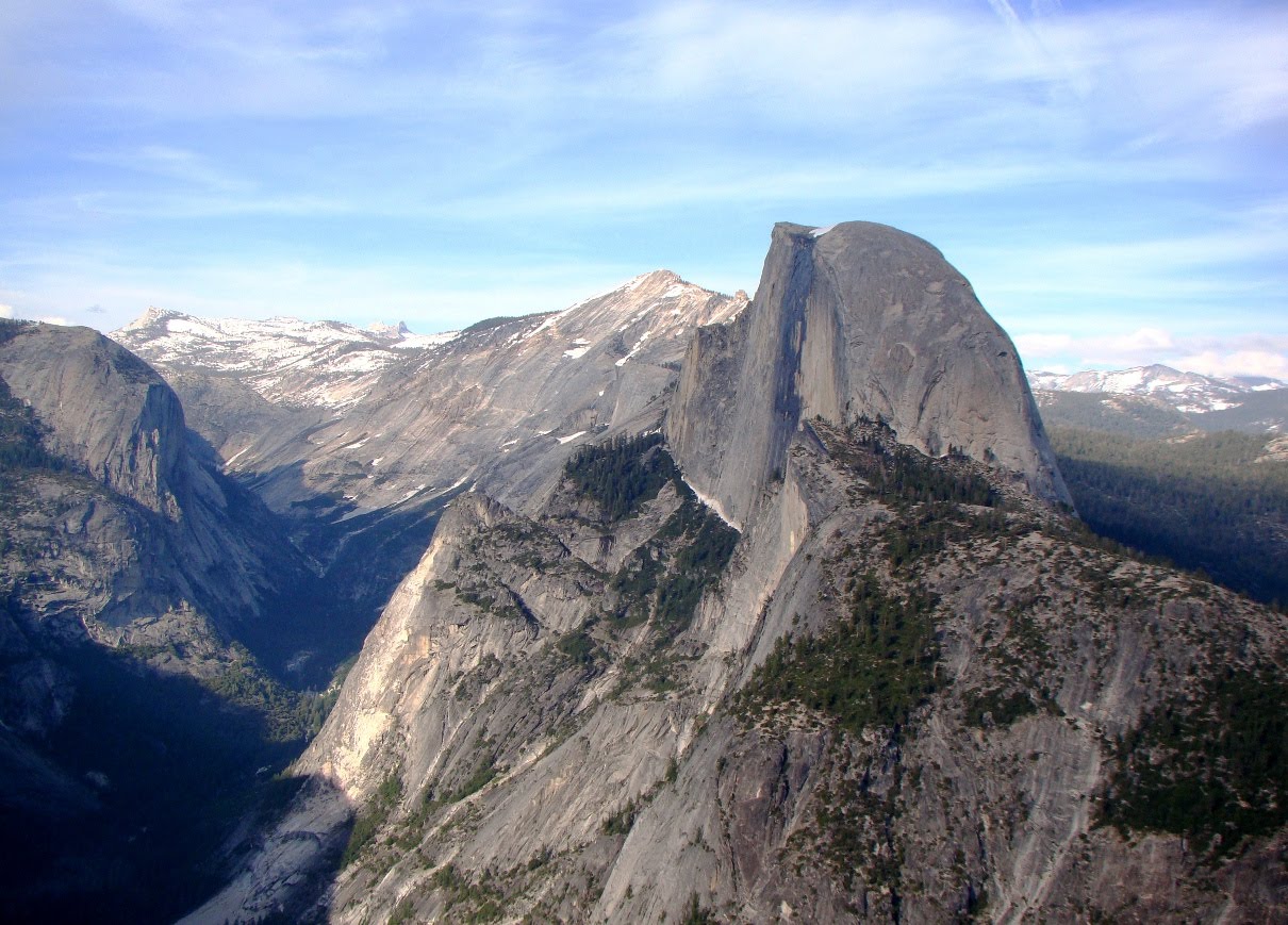
Tis-sa-ack is, along with Yosemite Falls and El Capitan, Yosemite Valley. The iconic rock stands high above the east end of the valley, rising to 8,839 feet (2,694 meters), just short of a vertical mile above the valley floor. It is perhaps the most instantly recognizable feature of the park. And one of the less understood features as well. Glaciation is often invoked as the origin of the unique shape of Half Dome, but glaciers only had a marginal role, as they never overtopped the dome. They only reached the base.
A view from Washburn Point, a bit more to the south than Glacier Point. Both views are looking roughly east.
Half Dome is composed of a granitic rock called  the Half Dome Granodiorite. The distinction of granite and granodiorite may be lost on some people, but here it is: both rocks contain the mineral quartz, but granodiorite has a somewhat higher proportion of plagioclase feldspar than it has of potassium feldspar. It will have a slightly higher proportion of mafic (dark) minerals like hornblende or biotite mica. But really, "granite" will suffice.

Many of the granitic rocks of Yosemite Valley are highly jointed, meaning that the rocks fractured as they were exposed at the surface by erosion. Jointing is also influenced by regional stresses, such as nearby fault zones. Jointed rocks are easily quarried by glacial action, and in Yosemite Valley, such rocks form the recessed parts of the canyon walls. Rocks like El Capitan and Half Dome have very few joints, and thus stand out as a monolithic cliffs and peaks.

The rounded shape of the dome is the result of exfoliation jointing. Exfoliation is the tendency to form slabs of rock parallel to the surface of the rock. Corners and edges are preferentially broken off, leading to the dome shape. The cause of exfoliation is still being researched, with a traditional explanation of pressure relief as the rock is exposed by erosion. More nuanced causes are related to thermal stresses and compressional forces within the rock. A rather stunning example of exfoliation in action was caught on film last year. Check out my post on the subject here: http://geotripper.blogspot.com/2014/09/ongoing-exfoliation-event-at-twain.html.

Whatever the cause of the exfoliation and doming, glaciers did play a role in the unusual shape of Half Dome. A planar joint forms the face of Half Dome, and it was glaciers in the valley below that quarried away the rocks on the other side of the joint. Boulders and blocks of Half Dome Granodiorite can be found miles downstream in Yosemite Valley.
Most visitors to Yosemite see the dome from the west, down in Yosemite Valley. Many visitors make the journey to Glacier Point or Washburn Point to gain a perspective from across the great chasm of the Merced River, and from an only slightly lower elevation. 

It takes just a bit of walking to Mirror Lake and the valley above to see Half Dome from the base. Somehow the dome looks huge from below.
Such vertical cliffs are not immune from gravity, no matter how strong the rock. As noted in the last post, a huge rockfall came off the rock on the flank of Half Dome in March of 2009. The Ahwiyah Point rock fall forever changed the appearance of Tis-sa-ack. But that's the nature of geology. Nothing on Earth remains the same, and some of those changes happen in a human time frame. Just ask the people of New Hampshire about their state emblem (story here). 
It isn't overly difficult to see Half Dome from the north. One needs merely to drive towards Tuolumne Meadows and stop at Olmsted Point. All of the other pictures in this post came from my trip last weekend, but the picture below came from one of the strangest journeys I ever had in Yosemite National Park. At the beginning of the current drought in 2011, practically no snow fell in November and December, so Tioga Pass was still open after New Year's Day in 2012. We went over the pass on January 5, and caught the sunset on the face of Half Dome. Catch some other pictures of that strange journey here and here.
That leaves, for me anyway, a couple of bucket list items: to see Half Dome from the south, from the east, and from under my feet! Here's hoping...

Friday, June 18, 2010

Half Dome is down to a Quarter! Will Anyone Want to Visit Yosemite?

OK, not really, I'm just continuing a brief series on Yosemite Valley encouraging folks to look behind and to the side of the iconic features like Half Dome, El Capitan, Yosemite Falls and Bridalveil Fall. Our "high-water journey" to Yosemite Valley last week included an excursion to Glacier Point, which had opened to visitors only a few days prior.

The views from Glacier Point, and the usually quieter Washburn Point, were spectacular, as they almost always are. Half Dome dominates the views, so I was trying to take a few shots that didn't have the granite monolith in the center. They appear below.

I am always struck by the grandeur of Tenaya Canyon, the main tributary valley to the Merced River that meets the Merced at the head of Yosemite Valley. I call it a tributary "valley" because Tenaya Creek is a relatively underfit stream, quite incapable of carving such a deep valley, one that rivals the Grand Canyon in depth.

Even the glaciers shouldn't have been big enough to carve such an impressive gorge, and they wouldn't have except that the vast ice sheet that covered the Tuolumne Meadows area to the north spilled over and contributed a vast amount of ice to the otherwise small Tenaya glacier system.
It was a week of the highest snow runoff, with the Merced River running at 7,000 cubic feet per second, about three times normal. So with a zoom shot, I was able to spy the rarely viewed Pywiack Cascades, in a trailless and inaccessible part of Tenaya Creek Canyon (an interesting description of the high adventure journey through this gorge can be found here). I would love to make that journey, but I'm getting just a bit old for such ventures!

If Half Dome didn't exist, North Dome and Basket Dome would certainly command more attention. Unlike Half Dome, these lower domes were probably covered by ice during the most intense glaciations, but in the last 800,000 years most of the shaping has been accomplished by exfoliation. Exfoliation is a form of unloading, in which the granite expands as it is exposed by erosion, cracking into slabs running parallel to the surface of the rock. The slabbing tends to break off corners and edges, leading to the characteristic dome shape.

The view from Glacier Point changed forever in March of 2009 when a huge rockfall, the biggest in two decades, thundered off of Ahwiyah Point below the cliffs of Half Dome. The light colored strip running across the photo above shows the path of the slab, and the pile of talus in the shadow shows the impact point. Hundreds of trees were blown down, and a popular hiking trail was covered, but luckily no one was hurt.

I know it is hard to see the view from Glacier and Washburn without actually noticing Half Dome, and so I did take quite a few pictures of it. One of them is below, if you are feeling only half-satisfied by the rest of the post!

Wednesday, November 2, 2011

How it was: The Last Days of Fall in Yosemite

We were in Yosemite last weekend, catching the last vestiges of the fall season, and exploring a landscape that was at the end of a cycle. Life was ebbing, preparing for the arrival of winter, which apparently intends to arrive on Thursday (a series of snowstorms is expected). As such, we were probably some of the last people who got to visit Glacier Point this year. It was a beautiful day (I would be more poetic about it, but words start to fail when trying to describe a place like this).
The peak of the fall colors was some time ago. We passed groves of trees that had lost all their leaves, but in some sections of the park, color was still intense. I understand that the eastern hardwood forests are the epitome of fall glory, but I also see wonder in catching the colors spread out in a dark conifer forest as the sun lights up the dogwood and oak understory.
 A spider was feverishly busy trying to catch a last meal for the season.
There were a few flowers still hanging on near the Merced River. This apparently is a Coneflower (my credentials as a biologist have always been suspect). The flowers were on their way out; the petals were gone on the other side of this one.
The Merced River was running slow and clear. Last spring I would have been standing in two or three feet of water at this spot.
We headed up the road to Glacier Point. The air was still and clear, and there were no clouds. The peaks stood out clear as crystal, and I couldn't help taking pictures of mountains and domes I've photographed many times before. It always seems like I am looking for unusual lighting and clouds to spice up pictures of these features, but today I was concentrating on preserving the peaks in plain afternoon sunlight. The pictures make me think of a baseline, a version from which all other pictures can be compared ("what do those mountains look like when they aren't shrouded in mysterious clouds?"). The exfoliation dome of Mt. Starr King appears below.
The Sierra Crest could be glimpsed in the distance, with Mt. Lyell, the highest peak in the park at 13,114 feet (3,997 meters) barely visible. Peaks of the Clark Range a little west of the crest tend to dominate the skyline. A few small patches of snow made it through the summer.
Half Dome sits across the valley from Washburn and Glacier Points. A zoom on the summit revealed no hikers; I'm guessing the cables are down by now, so no one was around.
Mt. Clark is a pretty nice example of a glacial horn, a peak that has been steepened on all sides by the plucking action of the glaciers that were here only 12,000-13,000 years ago.
I was reminded while looking at Tenaya Canyon below Half Dome how much geology changes the park. If you remember this view from any time before 2009, it is forever changed now. The Ahwiyah Point rockfall produced the long white scar down the slope in the center-left side of the photo. It was the biggest rockslide in more than two decades.
Glacier Point offers one of the greatest views to be seen anywhere. The cliffs drop 3,000 feet below one's feet, and there is a unique perspective of the famous waterfalls, since they are being observed from above. Yosemite Falls had the smallest of trickles falling down the face (the bright sunlit cliff). In a few days ice will replace water on the cliff face.
On the way down Glacier Point road, we stopped for a look at Summit Meadow. The willows had turned red, contrasting with the yellow meadow grasses and the evergreen lodgepoles. To get the reflections on water, I had to get out into the middle of the meadow, which is not really a nice thing to do, since the trampled grass and mud is unsightly, and it damages the soils. So I found a way to get there without stepping on grass...
 And there it is, a fallen tree. It was a real balancing act to not fall off.
And that's the way it was. I saw reports that it was very windy in the valley today, and that snow level will be down to 3,500 feet or so by the end of the week. Yosemite will be a very different place by the weekend.

Sunday, April 5, 2009

A Final Look (for now): The Ahwiyah Point Slide in Yosemite


When the Ahwiyah Point Rockfall impacted after a tumble of 1,800 feet, the slabs and boulders of granitic rock exploded, producing an airblast that is reported to have flattened hundreds of trees (and also producing a magnitude 2.4 earthquake). It also pulverized the rock. Completely. As I walked on the north side of the Mirror Lake Loop Trail, I didn't see anything right away, but then I nearly slipped and fell on a granite boulder that would normally provide fine traction. I looked and realized the boulders around me were covered with a fine powder up to a quarter inch thick. It looked like volcanic ash, and it occurred to me and my students that the dust would actually be chemically indistinguishable from rhyolite tuff (granite and rhyolite are coarse- and fine-grained varieties of silica-rich igneous rock). It really didn't even feel gritty, and it got all over our shoes and pants.

We were on the far outer periphery of the impact zone, so only a few weakened tree trunks were knocked over. Several are shown in the second photo.

That's all I have on the slide for now. I hope to be able to get closer to the impact zone on my next trip in the area.

Tuesday, May 3, 2011

Reflections on Yosemite and Mass Wasting

OK, not philosophical reflections, but literal reflections. One of my favorite spots to visit on the floor of Yosemite Valley is the Mirror Lake area, due to the relative peace and serenity brought about by the lack of cars and other urban distractions. Just people walking about quietly. Mirror Lake is not exactly a lake, and not exactly a river, and for a good part of the year it is entirely dry.

Tenaya Creek is a relatively minor tributary of the Merced River, but Tenaya Canyon is nearly as deep as the Grand Canyon. That would seem to be a bit of a mystery, since the size of glaciers in a canyon can be roughly comparable to the size of the watershed, and it looks like there was a very large glacier here. Studies of the glacial topography help to explain the disparity: large masses of glacier ice spilled over the divides from the Tuolumne River drainage, adding to the ice load in Tenaya Canyon. As big as they were, glaciers never overrode the summit of Half Dome, which looms thousands of feet above the lake. They instead undercut part of the base of the dome, taking advantage of joint patterns in the granitic rock to quarry rock away from the 700 foot-high face.Mirror Lake developed several thousand years ago when a large rockfall collapsed off the north wall of the canyon, damming up Tenaya Creek. The lake mostly filled with sand and was turning into a meadow, but heavy riverflows during spring runoff scoured out the river channel and left some very wide pools that are excellent for photographing (and just appreciating) the cliffs and domes that are reflected from above.

Lest one thinks that the rockfalls in Yosemite are a thing of the past, a large rockfall occurred here just a few years ago (see some posts on the Ahwiyah Point fall here and here). Ahwiyah Point is the prominent summit just east of Half Dome (below). The rockfall destroyed hundreds of trees, and a hiking trail, which is still closed to entry due to continuing danger from falling rocks.

Mirror Lake is not hard to get to (a tram stops just about a mile away), and one can even ride a bicycle most of the way up. There is a small network of trails around the pools, and the main trail climbs out of Yosemite at Snow Creek. It is a very beautiful corner of a very beautiful valley. Don't miss it if you get a chance to visit!

Thursday, April 9, 2009

The Ahwiyah Point Rockfall: the View I Wish I Had


Photos courtesy of the National Park Service. Photographer: Greg Stock, Park Geologist

The National Park Service now estimates that the March 28 Ahwiyah Point Rockfall had a volume of 43,000 cubic meters, or 115,000 tons. This means that the event was almost 50 percent larger than the 1996 Happy Isles Fall (30,000 cubic meters), and is the largest event since the 1987 Middle Brothers slide (1.5 million tons). The airblast was reminiscent of the Happy Isles event.

These pictures, taken by Greg Stock, the park geologist, show the views I wish I had when I was there last weekend. The top photo is from the switchbacks to Snow Creek, and the other is obviously from the edge of the destruction zone.

For some strange reason, rock climbers have been inordinately interested in this event, and the effect it may have had on some of the Half Dome climbing routes. Via Geology.com, here is a comment string replete with photos from a number of climbers.

Sunday, April 5, 2009

Another Look: The Ahwiyah Slide in Yosemite


The Ahwiyah Point rockfall in Yosemite Valley was probably the largest rockfall since 1996, when the Happy Isles fall killed one person and severely damaged the Nature Center (photo here). Luckily the slide a week ago occurred early in the morning so no one was on the trails covered by the event. Access is a bit tricky, but good views of the entire pathway of the slide can be had from the trail north and east of Mirror Lake (the south side of the loop is covered with rockfall debris). Unfortunately (for us geologists) views of the impact area are not so easy; I didn't have time to bushwack across the river, and it was probably still very dangerous in the impact zone anyway.

The first photo shows the entire rockfall zone, from near the top of Ahwiwah Point to the base of the canyon slope on Tenaya Creek. The high rock on the right side is Half Dome, from an angle not often seen by casual tourists (it requires a one and a half mile hike, after all!). The total length of the fall was 1,800 feet.

The second is a zoom on the release point (sorry for the intervening branches; I took about 30 pictures and zoomed only the one time! There were clearer views elsewhere). The nearby trees provide scale; the rock mass was dozens of yards across.

The third and fourth photos provide the only view I could get of the impact zone. Lots of new talus slopes up there, lots of mangled logs, and if you look very carefully at the top of the talus pile, you can see a single tree that survived the onslaught of falling rock.

One more set of photos in the next post!

Monday, May 5, 2014

Two Serene Hours in a Very Noisy Place: The North Valley Trail in Yosemite Valley

Yosemite Valley is an awe-inducing place, a place that was the inspiration for my current series on "What are the Most Incredible Places You've ever Stood"? I've been there many times and I never get tired of it. It is a destination for three of my field trips every year. It is an easy thing to drag a bunch of students up there (you make it required and stuff them on a bus), but how does one get past the sheer elegance of the scenery and explain to students the grandeur of the geological story of Yosemite as well? Part of it is letting them find out for themselves.

It's a bit of a trick to take 40 students to Yosemite on a busy Saturday in May. Buses are allowed to park in only two or three spots in the valley, and an extended discussion of geology is not possible in a place like the Wawona Tunnel View (above and below). It's simply too crowded with noisy buses and motorcycles and hundreds of tourists enjoying a first view of the valley, and it's really not fair to have a bus parked there hogging a premium spot. So we park the bus at Yosemite Lodge, and I set them free to wander through the park...to an extent. We make appointments. They find their way through the valley floor on the free trams, and we meet each other at a few of the most important localities (principally the Happy Isles rockfall site and a vantage point where we can talk about Half Dome and Yosemite Falls). It works well most of the time because they get a sense of exploration to go with the "learning".
I like the schedule for a different reason. The students have about two hours to find the visitor center and make a series of observations while making their way through the tram system to the other end of the valley. That's two hours that I can use to make some observations of my own, along with a bit of exploration. The trams are great, but nothing can compare with walking the length of Yosemite Valley on one of the less busy valley trails. Two hours of brisk walking for me equates to about six miles. I headed up the trail to Lower Yosemite Falls, trying to make my way through hordes of tourists (and a fair number of my students headed the same direction). It was crowded and noisy, but only a few hundred yards further I had the trail largely to myself.
 The North Valley Trail follows the base of the cliffs above the roads and valley developments. It is surprisingly quiet; I couldn't hear the traffic far below, only the breeze through the conifers and pleasant song of a bird I couldn't see or identify.
I soon passed a superb example of a talus slope at the base of Yosemite Point. In many places the cliffs of Yosemite are bold and vertical, but in other places there are recessed coves with extensive slopes of fallen rocks. The difference lies in the pattern of jointing in the rock. Granitic rocks form deep in the crust miles below the surface under great pressure. As they are exposed by erosion, the rocks expand and fracture. The composition of the rock seems to determine the spacing of the joints, and when they are far apart, bold cliffs occur. When they are closely spaced, rock falls are common and talus slopes are the result.
The trail climbs several hundred feet above the valley floor, offering views in both directions. Across the valley stands Sentinel Rock, one of the most imposing cliffs in Yosemite (although it sometimes gets lost in the scenery, being located across the valley from Yosemite Falls). On the other side are the cliffs of the Three Brothers. The cliffs that make the three brothers are more easily seen from the other side, but from my vantage point I could see the scar of the 1987 Three Brothers rockslide, which dumped something like 600,000 cubic yards of debris onto the valley floor. Luckily no one was hurt, since the park service had some warning that a big slide was imminent and closed the road at the base of the cliff. It was the largest mass wasting event in the recorded history of the valley.
John Muir and other earlier visitors remarked on the open park-like aspect of the woodlands on the valley floor. Fire suppression since the establishment of the park in 1890 has allowed the growth of a thick forest across most of the valley, but below the Royal Arches and Washington Column there are some beautiful old oaks that recall the original state of the valley at the time it was discovered by Europeans (the Miwoks and other first nation people have known of the valley for thousands of years).
Half Dome soon became visible as I worked my way towards Mirror Lake.
 The Dogwoods were still blooming along the side of the trail.
After three or four miles of walking I arrived at Mirror Lake. The "lake" is more of a wide spot in Tenaya Creek that developed as a result of a gigantic landslide in prehistoric time. The creek formed a series of ponds behind the rockslide that in springtime reflect the surrounding cliffs, especially Mt. Watkins and Half Dome. By summer Tenaya Creek often runs dry (especially this year with the drought conditions). On Saturday it was beautiful, but also crowded. I set off towards Happy Isles and soon left the crowds behind.
Half Dome from the vantage point of Mirror Lake is the very definition of "looming". It is nearly 4,000 feet of steep cliffs. Another major mass wasting event took place near here in 2009, the Ahwiyah Point rockfall. It involved something like 115,000 tons of granitic rock. Luckily it happened early in the morning and no one was hurt.
The small details are easy to miss in a crush of people. I enjoyed some more Dogwood flowers...
...and the hard work of huge bumblebee in the Lupine blooms.
After I met with the students at Happy Isles, we started making our way back to Yosemite Lodge. I took one look at the packed tram, and decided it would be nicer to walk back. The direct route was two or three miles, and I had a fair chance of beating the tram (the dozen or so stops and the heavy traffic made for a slow motorized journey). Along the way I was thrilled to see a White-headed Woodpecker for the first time.
Our final stop was in a meadow at the base of Yosemite Falls. It provided an outstanding view of Half Dome where we could discuss the origin of the iconic feature. Soon after we were back on the bus and headed home. It was a spectacular day!