Showing posts with label Mt. Watkins. Show all posts

Thursday, May 14, 2015

Is This the Best View from a Tunnel Anywhere? And Other Slightly Unfamiliar Views of Yosemite (and Gratuitous Bear Cub)

I did something a little different this last weekend for Mother's Day. I found there was a single campsite available in Yosemite Valley on Sunday night, so we headed there for a little explore. I also did something just a little bit different at Tunnel View, and walked a bit into the tunnel to get the iconic view of Yosemite Valley framed by the arching granite of the tunnel entrance. Is there a tunnel exit anywhere in the world with a more incredible sight at the end? I'd love to hear any ideas.

I found out something about sound in tunnels. A car or truck can be a quarter mile away in the tunnel, but the sound of the engine is funneled and reflected to the point that it sounds like a jet plane right behind you. It was mildly terrifying.
In any case, we concentrated on visiting some of the spots I don't get to see when I take students there on a field excursion. Those spots include the Mariposa Grove of Sequoia Trees from the last post, Glacier Point, Washburn Point, and Mirror Lake. The picture above is the view of Yosemite Valley from the slopes of Turtleback Dome just west of the tunnel. I don't enter the valley from that direction as often, so the iconic rocks like Half Dome and El Capitan seem just a tad less familiar, and thus all the more spectacular.
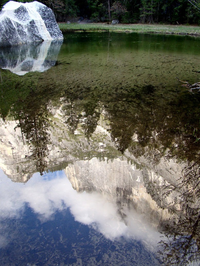
Mirror Lake is a deep bend in Tenaya Creek that backs up during the spring runoff to flood the adjacent meadow and form a wonderful reflecting pond. The pond formed because of a huge prehistoric rockfall that blocked much of the canyon floor. It is probably the largest slide documented in Yosemite Valley. A number of rockfalls have occurred in historic time as well. In March 2009, the Ahwiyah Point rock fall left the white scars on the cliff in the picture above on the right. It involved 46,700 cubic meters of granitic rock. Fortunately the slide occurred early in the morning and no one was injured.
Cathedral Rocks are very famous and familiar from the west side where Bridalveil Falls spill over the cliffs. From the east, they are sometimes overlooked as the cliffs across the valley from El Capitan. In any other setting in the world, these rocks would be as iconic as El Capitan or Half Dome.
People who are on short trips miss out when they only visit the valley floor. An excursion to Glacier Point offers one of the greatest panoramas in the world, seeing the entire extent of Yosemite Valley from 3,000 feet above. The video below shows part of the sweeping view. But if you make the time to see Glacier Point, don't miss Washburn Point. It gives an entirely different perspective of "Half Dome". What works better? Four-fifths Dome? Three-quarters Dome?


As promised, here is the gratuitous bear cub. The bears are emerging from hibernation, and we saw a mother Black Bear and her cub above the highway near Chinquapin (the turnoff to Glacier Point). They were being good and doing bear things in the forest instead of breaking into cars in a campground. It's taken a few years, but most of the tourists have finally been trained to stop luring bears into the campgrounds, and the crafty old campground bears have died off or retired, and there aren't new mama bears teaching their cubs how to break in. In the late 1990s nearly a million dollars of damage was done by the bears, but in the most recent year the damage was only about $5,000. For the record, although the bears are incredibly strong and heavily armed (clawed), they have been very patient with humans. There has not been a single fatality in the Sierra Nevada that can be attributed to a Black Bear. We have unfortunately killed lots of them, mostly with traffic collisions. The extinct California Grizzly Bears were a different story.
Only a fraction of the Black Bears in Yosemite are actually black. They range from black to brown to blonde. If the cub above is looking a bit bedraggled, it is losing its winter coat. I may seem close from this view, but I was a good 200 feet away and across the road. A zoom lens is a wonderful thing in wildlife photography!

Monday, May 5, 2014

Two Serene Hours in a Very Noisy Place: The North Valley Trail in Yosemite Valley

Yosemite Valley is an awe-inducing place, a place that was the inspiration for my current series on "What are the Most Incredible Places You've ever Stood"? I've been there many times and I never get tired of it. It is a destination for three of my field trips every year. It is an easy thing to drag a bunch of students up there (you make it required and stuff them on a bus), but how does one get past the sheer elegance of the scenery and explain to students the grandeur of the geological story of Yosemite as well? Part of it is letting them find out for themselves.

It's a bit of a trick to take 40 students to Yosemite on a busy Saturday in May. Buses are allowed to park in only two or three spots in the valley, and an extended discussion of geology is not possible in a place like the Wawona Tunnel View (above and below). It's simply too crowded with noisy buses and motorcycles and hundreds of tourists enjoying a first view of the valley, and it's really not fair to have a bus parked there hogging a premium spot. So we park the bus at Yosemite Lodge, and I set them free to wander through the park...to an extent. We make appointments. They find their way through the valley floor on the free trams, and we meet each other at a few of the most important localities (principally the Happy Isles rockfall site and a vantage point where we can talk about Half Dome and Yosemite Falls). It works well most of the time because they get a sense of exploration to go with the "learning".
I like the schedule for a different reason. The students have about two hours to find the visitor center and make a series of observations while making their way through the tram system to the other end of the valley. That's two hours that I can use to make some observations of my own, along with a bit of exploration. The trams are great, but nothing can compare with walking the length of Yosemite Valley on one of the less busy valley trails. Two hours of brisk walking for me equates to about six miles. I headed up the trail to Lower Yosemite Falls, trying to make my way through hordes of tourists (and a fair number of my students headed the same direction). It was crowded and noisy, but only a few hundred yards further I had the trail largely to myself.
 The North Valley Trail follows the base of the cliffs above the roads and valley developments. It is surprisingly quiet; I couldn't hear the traffic far below, only the breeze through the conifers and pleasant song of a bird I couldn't see or identify.
I soon passed a superb example of a talus slope at the base of Yosemite Point. In many places the cliffs of Yosemite are bold and vertical, but in other places there are recessed coves with extensive slopes of fallen rocks. The difference lies in the pattern of jointing in the rock. Granitic rocks form deep in the crust miles below the surface under great pressure. As they are exposed by erosion, the rocks expand and fracture. The composition of the rock seems to determine the spacing of the joints, and when they are far apart, bold cliffs occur. When they are closely spaced, rock falls are common and talus slopes are the result.
The trail climbs several hundred feet above the valley floor, offering views in both directions. Across the valley stands Sentinel Rock, one of the most imposing cliffs in Yosemite (although it sometimes gets lost in the scenery, being located across the valley from Yosemite Falls). On the other side are the cliffs of the Three Brothers. The cliffs that make the three brothers are more easily seen from the other side, but from my vantage point I could see the scar of the 1987 Three Brothers rockslide, which dumped something like 600,000 cubic yards of debris onto the valley floor. Luckily no one was hurt, since the park service had some warning that a big slide was imminent and closed the road at the base of the cliff. It was the largest mass wasting event in the recorded history of the valley.
John Muir and other earlier visitors remarked on the open park-like aspect of the woodlands on the valley floor. Fire suppression since the establishment of the park in 1890 has allowed the growth of a thick forest across most of the valley, but below the Royal Arches and Washington Column there are some beautiful old oaks that recall the original state of the valley at the time it was discovered by Europeans (the Miwoks and other first nation people have known of the valley for thousands of years).
Half Dome soon became visible as I worked my way towards Mirror Lake.
 The Dogwoods were still blooming along the side of the trail.
After three or four miles of walking I arrived at Mirror Lake. The "lake" is more of a wide spot in Tenaya Creek that developed as a result of a gigantic landslide in prehistoric time. The creek formed a series of ponds behind the rockslide that in springtime reflect the surrounding cliffs, especially Mt. Watkins and Half Dome. By summer Tenaya Creek often runs dry (especially this year with the drought conditions). On Saturday it was beautiful, but also crowded. I set off towards Happy Isles and soon left the crowds behind.
Half Dome from the vantage point of Mirror Lake is the very definition of "looming". It is nearly 4,000 feet of steep cliffs. Another major mass wasting event took place near here in 2009, the Ahwiyah Point rockfall. It involved something like 115,000 tons of granitic rock. Luckily it happened early in the morning and no one was hurt.
The small details are easy to miss in a crush of people. I enjoyed some more Dogwood flowers...
...and the hard work of huge bumblebee in the Lupine blooms.
After I met with the students at Happy Isles, we started making our way back to Yosemite Lodge. I took one look at the packed tram, and decided it would be nicer to walk back. The direct route was two or three miles, and I had a fair chance of beating the tram (the dozen or so stops and the heavy traffic made for a slow motorized journey). Along the way I was thrilled to see a White-headed Woodpecker for the first time.
Our final stop was in a meadow at the base of Yosemite Falls. It provided an outstanding view of Half Dome where we could discuss the origin of the iconic feature. Soon after we were back on the bus and headed home. It was a spectacular day!

Saturday, May 22, 2010

Why Do They Call It "Mirror Lake"? A Day in Yosemite Valley

I really can't call today's post part of the "Other California" series because Mirror Lake is probably one of the most photographed spots in Yosemite Valley except for a couple of waterfalls and vertical cliffs. It is a rarer experience than the other iconic places in the valley because Tenaya Creek tends to dry up to a trickle and is not able to flood the area as effectively as it does in late spring, so many summer tourists never get to see it (I've seen many confused people searching for the lake in August).

The most famous view of Mirror Lake is the angle that includes Mt. Watkins (made famous by Ansel Adams), but Half Dome looms directly above the lake, and makes for some memorable reflections as well. Mirror Lake is one of the most serene and quiet of the iconic places in Yosemite Valley because automobiles are restricted (only a few handicapped spots), so nearly all who visit get there on bicycles or on foot.

One might be shocked to know that many of the famous corners of Yosemite Valley were once heavily used for other purposes. Some of the meadows were replanted with grasses better suited for cattle grazing so steaks could be served in the earliest hotels. Another meadow near the Ahwahnee Hotel was a golf course until 1981. Swampy areas of the valley floor were drained. And Mirror Lake was once utilized as a source of blocks of ice in the days before electric refrigeration. Because the lake was constantly filling with sand, the Park Service would quarry the sand and use it to spread on icy roads in the valley. The practice ended in 1971.

One would expect that sands would fill the lake and it would eventually become another meadow, but the high spring runoff has a scouring effect that maintains a number of permanent pools (at least when the river is flowing). There is also a bouldery dam at the edge of the meadow (below).

Some notes on the lake:

"The Indian name is commonly given as “Wai-ack”, meaning “water rock,” and was sometimes applied to Mt, Watkins too. Bancroft in his early guide book, and Hutchings, give the name “Ke-ko-too-yem” which they translate as meaning “sleeping waters”. From Yosemite Valley Place Names.

From my geological road guide to Yosemite Valley:

Mirror Lake lies about 1 mile northeast of the road junction next to the moraine. Although it is called a lake, it earns that designation only during periods of highest river flow. The lake formed behind a rockslide estimated at 11.4 million cubic meters, the largest slide so far identified in Yosemite National Park (Wieczorek et al., 1992). The "lake" has been rapidly filling with sand and gravel, and for years the National Park Service attempted to maintain the lake by dredging and by constructing small sediment catch-dams upstream (Ditton and McHenry, 1989). More recently, sediment has been allowed to flow into the lake, and although it is smaller than it once was, some ponding will always be present due to the scouring effect of spring runoff.

Ditton, R.P., and McHenry, D.E., 1989, Yosemite Road Guide, Yosemite Association, 79 pages.

Wieczorek, G.F., Snyder, J.B., Alger, C.S., and Isaacson, K.A., 1992, Rock Falls in Yosemite Valley, California, U.S. Geological Survey Open File Report 92-387, 186 pages.