Update, February 22, 2011:A horrific aftershock of magnitude 6.3 struck the Christchurch area yesterday, and dozens of people have been killed. I am saddened by the loss of life and hope the best for the survivors. Some may be wondering why the damage is worse with a lesser aftershock. The quake yesterday was closer to Christchurch and more shallow. That alone can account for the great amount of damage, but building damage is also cumulative. Many of the buildings damaged in September had not been fixed or reinforced, and thus were subject to collapse with the newer quake. Please check here for up-to-date geological information.The original post follows:Quick, think of a place in the world where a transform boundary has formed a seriously big fault line, a place where folks are waiting for the "Big One", a place where a magnitude 7 quake is not considered the "Big One" (and think of how people don't really want to think about that)....

Not San Francisco Bay! This is Lyttelton Harbour near Christchurch, New Zealand.
If you are one of my local readers, you will be forgiven for thinking of California, where the San Andreas and many other active faults threaten a large population, and where memories of the 1989 Loma Prieta quake, the 1994 Northridge quake, the 2003 Paso Robles quake, and the 2010 Baja quake are still raw. But this year, we have seen other places where elements of the geology are similar, and where disastrous earthquakes have occurred. Last January, Haiti was devastated by a magnitude 7.0 quake on a strike-slip (horizontal movement) fault zone along a transform plate boundary in the Caribbean Sea, and yesterday Christchurch and other towns on the Canterbury Plain of the South Island of New Zealand were shaken by a magnitude 7.0 event. There are some chilling comparisons to be made between these events (and the 8.8 magnitude event in Chile last February). Chris at Highly Allochthonous has a nice review of the
geological background of the earthquake.
I was saddened to hear of the earthquake in Christchurch, and was relieved that there were so few casualties despite the widespread damage. I was privileged to visit there for all of 24 hours back in 2004, but I found it to be a pleasant town in a beautiful geologic setting. My prayers are with those in the region, because although few were injured, the population faces weeks or months of difficult times. Sewers and water lines, gas mains, and other types of infrastructure were severely affected by the shaking, and
as many as 20% of homes are uninhabitable.

There are some similarities between the South Island of New Zealand and California: The Alpine Fault is a large scale strike-slip fault system like the San Andreas, which is capable of producing large earthquakes in the range of magnitude 8 (a related fault on the North Island, near Napier, generated a 7.8 quake in 1931, killing 256 people). Like the San Andreas,
a bigger quake is expected in the "near" future along the South Island stretch of the fault zone, the so-called "Big One". There are high mountain ranges, the Southern Alps, and the Kaikouras, that might remind some of the Sierra Nevada, although the geological circumstances are different.

Some comparisons are more harrowing. The Baja quake this year and the one in Christchurch both involved few casualties, despite magnitudes of 7.2 and 7.0 respectively. Yet in Haiti, a 7.0 magnitude quake killed more than 200,000 people. Why? There are a number of factors: the Baja quake was in a lightly populated area, for one. But 500,000 people lived in the area affected by the New Zealand quake yesterday. One difference: the New Zealanders have a history of damaging quakes, and have high architectural standards. In Haiti, it had been 300 years since a large earthquake had taken place, and the country is so poor that they couldn't afford to enforce standards even if they had laws on the books.
Another possibility may have saved a great many lives in New Zealand: the quake may have actually been a
complex event involving three different quakes. The first quake may have been a 5.8 magnitude foreshock five seconds before the main shock. Five seconds is an eternity in an earthquake, enough to wake people to full consciousness, and enough time for them to make the right survival decision by taking shelter.
It wasn't long before the word "miracle" popped up
in relation to the earthquake in New Zealand. I have a real problem with the use of that word in relation to natural disasters. Miracles are invoked if hardly anyone was hurt, as if God (or the gods) were smiling on the folks where the earthquake was happening. But "miracle" is also a term used when rescuers reach a trapped person days after a quake when thousands of others are dead. What does that mean to the families of those who were killed? Why was one person "chosen"? When dealing with natural disasters, we really have to look at the fact that some societies have the resources and knowledge to protect their citizens, and others, whether from corruption or external economic factors, do not. If someone survives a disaster, it is often the result of planning, education, and available resources.
Some of the most despicable people on this planet are the ones like the 'evangelist' Pat Robertson who are so quick to declare that natural disasters are the judgement of God upon people.
Mr. Robertson rather stupidly declared that the Haiti earthquake happened because of a pact with the devil 200 some years ago. Why would anyone worship a god so capricious and inefficient that he waits 200 years to get around to punishing the children of the children of the children of the people who committed some kind of sin? Picking and choosing the reasons for a particular natural disaster in regards to the judgement of a deity is a dangerous and evil pathway that will someday come back on you.
My religious and ethical beliefs speak of the equality and value of each human being on this planet, but our planet is not a very equal place. Sometimes, certain citizens of the richest countries have an arrogance and sense of entitlement that is not actually particularly deserved.
Any of us could become a victim of a natural disaster at any time. Haiti is still in a desperate place; have you donated anything lately to help?
Postscript: See
this article in "Ask The Pilot" for a perspective on "miracles" in plane accidents.
Postscript 2: An excellent post on the fault offsets on the Canterbury Plain, with maps and photos
can be found here.
 I was so pleased to see all the columns showing up in the geoblogosphere this week! Columnar-jointed columns that is. I added to the cacophony with shots from my field trip last week to Devils Postpile and the Owens Gorge east of the Sierra Nevada. The great collection of pictures that followed have been linked by Lockwood at Outside the Interzone. Check them out!
 When I got on the plane for the Scotland trip in 2001, I had taken a grand total of 3 pictures on my very first digital camera. I barely knew what I was doing, and took only a handful of high resolution shots on one of the greatest trips of my life. I wish I could do the whole trip again, though, with the camera and experience I have now (and isn't just about all of life like that?).
 Here are some of the columns lying on the beach below the cliffs.


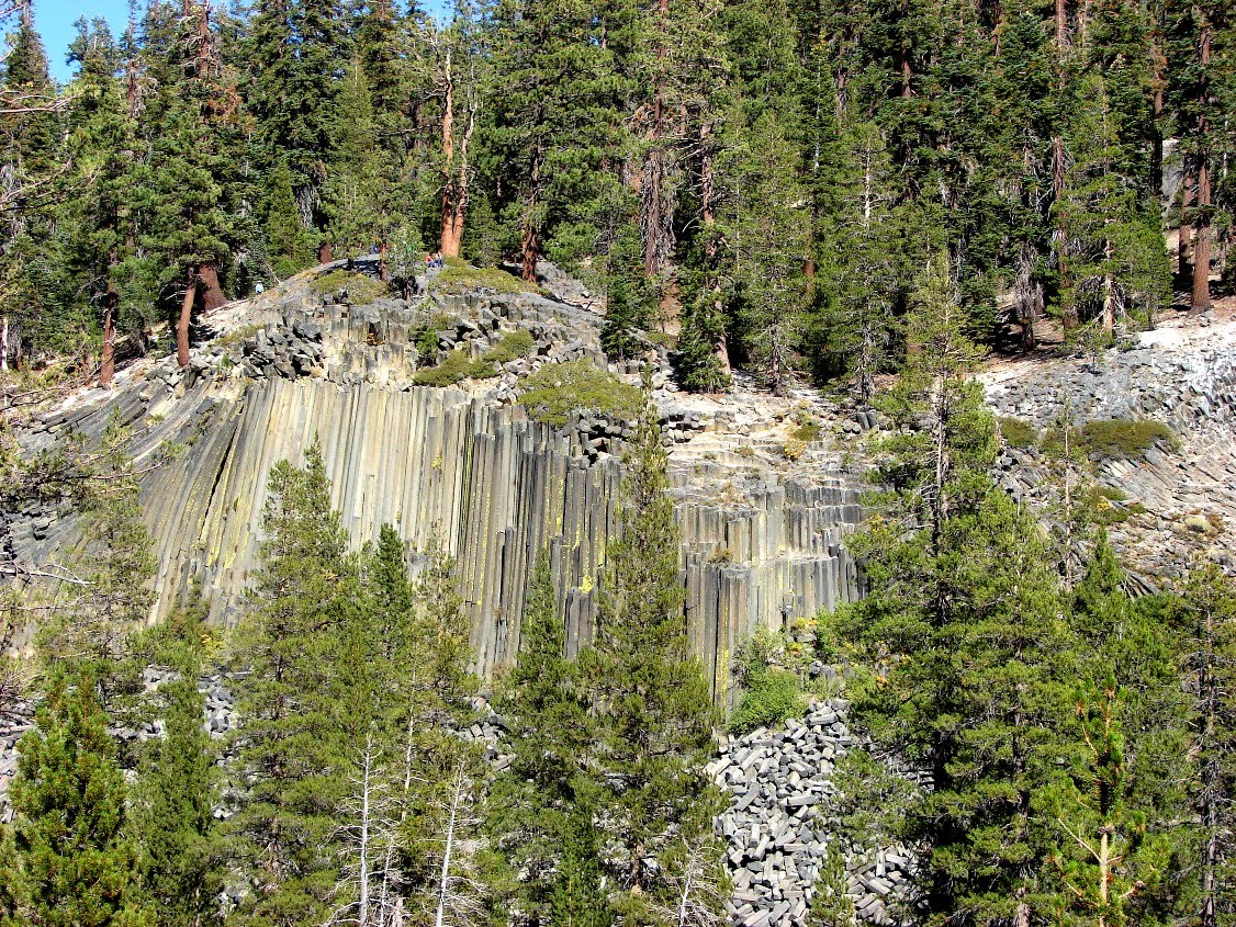

 Devils Postpile National Monument


 The Pali cliffs formed in part because of one of the giant landslides that have originated on the different Hawaiian islands, landslides that carried debris for dozens of miles out to sea, and caused massive tsunamis not seen or experienced in human history. I discussed one of these incredible events


