Showing posts with label cinder cone. Show all posts

Monday, February 27, 2017

Volcanoes in the Mist (and underground): Travels in Death Valley

The Inyo Mountains, in any other setting in the world, would be considered a major mountain range, preserved as a national park perhaps, and celebrated as scenic wonderland. But just like an accomplished sibling overshadowed by a more famous brother or sister, the Inyos lie across the valley from the most spectacular part of the Sierra Nevada, and south of the higher White Mountains. For better or worse (mostly better), only a few roads penetrate the range, including the main western highway into Death Valley National Park, State Route 190. That was the road we followed on our recent exploration of Death Valley.
As was noted in the previous post, we attempted our trip during the Bombogenesis storm that wreaked havoc across Southern California. This kind of storm can often result in disaster as highways get closed or damaged by landslides, but we were lucky and were able cross the Inyo Mountains and Darwin Plateau without problems. But we did get the opportunity to see some great geology, and even were able to add a new stop to our itinerary (because we missed a different one, but I'm not complaining).

Our first sight as we approached the mountains was the snow covering the desert peaks (first picture above), a hint to the seriousness of the storm we were challenging. The tilted rocks are Paleozoic-aged (300-550 million years) limestone layers. They recall a time when California was very different, completely submerged under a shallow tropical sea. We would be seeing more of these fascinating rocks later on. The road crossed the flat uplands of the Darwin Plateau, and then plunged down a steep incline towards the Panamint Valley.

We actually had fog in this arid environment, since the clouds were crowding against the edge of the steep mountains. As we passed the Father Crowley Vista Point, the clouds briefly parted and we had a view into the deep gorge of Rainbow Canyon. At this point, the slopes and flats are covered with basaltic lava flows ranging in age from 8 to 4 million years old. The immediate question becomes, why volcanoes? Why right here?

In a sense, volcanism is possible almost anywhere on the planet. It's not that there is magma everywhere, but that a hundred miles beneath our feet there is a zone, the asthenosphere, where the rock is almost molten, but not quite (perhaps 5-10% liquid). To melt this rock and create volcanic activity would require raising the temperature (as happens at hot spots like Hawai'i), or releasing pressure (pressure keeps the rocks from melting in the same way that pressure cookers prevent water from boiling). There aren't any hot spots in the immediate vicinity, but the crust across the Basin and Range Province has been stretched and thinned, allowing pockets of basaltic magma to form and rise into the rocks above, often following fault zones to the surface.
Although we couldn't see it through the clouds, there are basaltic lavas across the Panamint Valley that are of the same age and the same exact composition as those at the vista point. In addition, the rocks across the deep valley have no obvious source (the picture below is from last year, a decidedly drier trip). The best explanation for these rocks is that the lavas flowed across an original surface that was later broken up by faulting when the Panamint Valley formed. Since the youngest volcanic rocks are just 4 million years old, the Panamint Valley is younger still. The Panamint Valley is more than a mile deep and 65 miles long! That's a lot of geologic activity in a short period of time.
Looking across the Panamint Valley towards Hunter Mountain. The dark rocks on the left summit area are identical to the rocks at Father Crowley Vista Point.
We made a stop along the road descending into the Panamint Valley to check out some spectacular exposures of the dikes and sills that once fed the eruptions of the basaltic lavas (most years we are in too much of a hurry to get a camping spot at Stovepipe Wells). The magma was following whatever weakness in the surrounding rock that could be exploited by the molten rock. In some cases, vertical fractures allowed the magma to rise, forming dikes. In other cases, the molten rock flowed between limestone layers, forming sills. This extraordinary roadcut (below) showed textbook examples of both kinds of intrusions in the same outcrop. The usually black basalt has been oxidized (rusted) to produce the strange reddish-brown color.
There's a saying that one should never blindly sit on the ground in the desert. There are just too many things with fangs, stingers, or spines. The barrel cacti were looking to grow quickly in these rare wet times!
We headed down the highway. We had reached Death Valley National Park, and we faced whatever Bombogenesis was going to throw at us...

Friday, June 24, 2016

The Hawai'i That Was: Walking a Lake of Fire in "the Little Source of Great Spewing"

Kilauea Iki eruption in 1959. The prevailing winds caused debris to pile up behind the fountain, forming the Pu'u Pau'i cinder cone. Source: US Geological Survey
Kilauea is one of the five major shield volcanoes making up the Big Island of Hawai'i. As we found in the last post in this series on the "Hawai'i That Was", Kilauea is the most active of the island's volcanic centers, with an ongoing eruption dating back to 1983. On our first full day on the island, we had a look at the smoking pit of Halemaumau, but in the afternoon, we headed over to Kilauea Iki ("little source of great spewing").
Kilauea Iki from the northeast rim. Pu'u Pua'i is the mound on the right. The steam and gas in the distance is the ongoing eruption of Halemaumau. This picture is from 2009; it was foggy at this point on our recent trip.
Prior to the 15th century, Kilauea Iki was not a crater at all, but was instead a small shield volcano called 'Aila'au. It collapsed in the aftermath of an eruption, forming a pit crater 800 feet deep (the present crater is only half that depth). One of the lava tubes formed in the eruption is today known as Nahuku (Thurston Lava Tube). It is lit, and is an easy walk from Crater Rim Road (good luck finding a parking spot on busy days). Our goal for the day was to hike the north rim of the crater, descend into west end of the crater itself, and then climb the east rim, a distance of about 3 1/2 miles.
If that looks like an abrupt dropoff to the left, it is; it's a sheer 400 foot cliff into the crater.

The trail begins in a phenomenal high altitude rain forest (4,000 feet, ~100"/year) composed mostly of native Ohi'a trees and ferns. On my last trip in 2009, the forest was filled with kahili ginger, an aggressive invasive species. It has pretty flowers, but forms thickets that crowd out the natives. I didn't see any at all this time, although I am sure they are lurking in the forest away from the trail (kudos to the trail crews removing them).

Another serious pair of problems in the native rainforests were the feral pigs and goats. The pigs arrived with the Polynesians over 1,000 years ago. The goats arrived with Captain Cook and his crew, the first Europeans to discover the islands in 1778. Both animals wreaked havoc on the forest. The animals were finally removed by the 1990s, so the forests at Hawai'i Volcanoes are approaching something resembling their original state.
Our first look at the Pu'u Pua'i and the crater interior

The day had been overcast, but as we passed in opening in the forest we could see across the crater to Pu'u Pua'i, a mountain that is younger than I am. The extraordinary eruption that produced this landscape began in November of 1959 as lava started pouring from a rift system on the south side of the Kilauea Iki crater. The eruptions consolidated into a single vent within a few days, and for the next five weeks, spectacular things happened.


Seventeen different times, lava shot high into the air, and the crater filled with millions of cubic yards of simmering basalt. At the end of an eruptive episode, some of the basalt would drain back into the vent, but as the weeks passed by, Kilauea Iki crater filled to a depth of 400 feet (recall the original crater was 800 feet deep). During the latest stages of the eruption, the lava fountain reached a height of 1,900 feet (580 meters), the highest ever recorded in Hawai'i.

In the aftermath of the eruption there was a brand new cinder cone, and a lake of molten lava. During the final draining event, the lake level dropped about fifty feet leaving behind a "bathtub ring" (sciency version: "lava subsidence terrace"). We descended out of the forest, over the bouldery terrace, and into a ghostly barren landscape. After a few minutes we passed the remains of the eruptive vent at the base of Pu'u Pau'i (below).
The eruptive vent of Pu'u Pau'i

From then on, we were walking on a lake of fire. The eruption may have ended in 1959, but a four hundred foot deep lake does not cool all at once. It doesn't take weeks, or even months. It takes decades. Four months after the eruption, the crust was only 9 feet thick! Drilling allowed researchers to track the cooling process. In 1967, the crust was 90 feet thick, and in 1975 it was up to 180 feet (See Hazlett's book for details). The lava lake was more or less solid by the late 1990s, but there is no doubt that it is still very hot down below. Whenever the rain starts (roughly every five minutes, it sometimes seems), steam can be seen rising from fractures in the lake surface (below). Steam rising up the old drill holes is hot enough to scald.

We continued across the surprisingly flat surface of the lava lake. There were pressure ridges and fractures here and there, but the trail was easy to follow, using ahu (cairns, or rock piles).

One of the most astounding things about this lake of fire is the stubbornness with which life seeks to take root. Native Ohi'as are one of the most adaptable trees on the planet. They can form hundred foot high canopies in the native rainforests, but they can also grow in one of the most ghastly environments possible, that of a fresh lava flow. We passed dozens of scraggly bush sized Ohi'as and hundreds of small ferns. Recall that the forest on the rim above is no older than 500 years. In a few centuries (barring new eruptions, which are likely), this barren surface will be a thick forest.

We reached the eastern edge of the crater just as the rain began to pour. The change back to rainforest was abrupt. We climbed four hundred feet up a relatively gentle gradient and found our way to the vehicles. We had crossed the lake of fire and survived!

We never really saw the sun on the day's journey, but when we visited in 2009, we were treated to a gorgeous rainbow as we set off across the crater floor. It was astounding.

If you ever have the chance to visit Hawai'i Volcanoes National Park and want to see a bit of the native environment of the islands (the Hawai'i that was...), this trail is one of your best chances to see what it was like.

Read more:
The Kilauea Iki Trail Guide from the National Park Service
Explore the Geology of Kilauea Volcano by Richard Hazlett (Hawai'i Pacific Parks Association)

Sunday, March 13, 2016

Invitation to a Drive-by Shooting (of a Superbloom) in Death Valley

Telescope Peak (11,043 feet) and the Death Valley graben and salt pan
Death Valley is one of the greatest geological national parks in the world. The largest U.S national park outside of Alaska, it exposes 1.7 billion years of earth history, with incomparable exposures of igneous, sedimentary and metamorphic rocks covering every geological era from the Proterozoic to the Cenozoic. Grand Canyon National Park has the reputation as a geological encyclopedia, but the exposures at Death Valley are more than twice as thick!  
Scarp of the Furnace Creek fault zone north of Furnace Creek Resort
My students and I make a trek to Death Valley every February on the President's holiday weekend. Our focus of course is on the geology, but this year involved some biology. Although Death Valley is one of the driest places in North America, when rain does come, seeds in the desert soils are waiting. When conditions are just right, maybe once a decade, there is a "superbloom" of desert wildflowers. There were the El Nino years 1998 and 2005, and there is now the El Nino year of 2016.
Panamint Mountains on the west side of Death Valley, with the gulch of Salt Creek on the valley floor.
The weather events have been extreme at times. A flash flood at the north end of park laid waste to the grounds at Scotty's Castle and eradicated a major highway. The usually dry desert wash had a flow estimated at 9,000 cubic feet per second. For comparison, the Tuolumne River back home is considered at flood stage with a flow of that magnitude. Imagine unleashing such a flow on a dry wash, add tons of mud and boulders, and you get the idea. Another flood wiped out the highway from Shoshone over Jubilee Pass into Death Valley. We had to change our normal itinerary in a big way.
North end of the Black Mountains in the vicinity of Furnace Creek
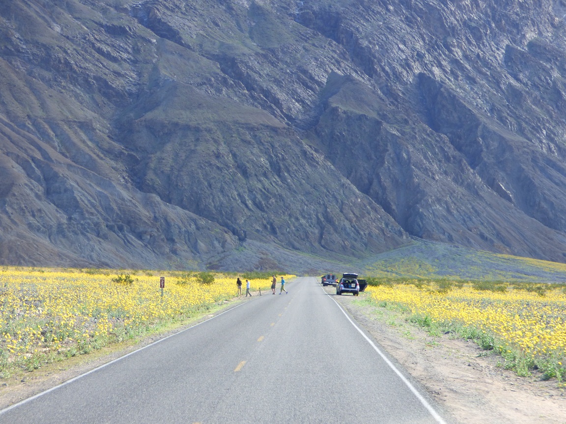
So it was that we found ourselves driving the entire length of the southern half of Death Valley so we could then make our leisurely geological explorations one after another on the way back. This plan gave us an overview of the geology of the valley, but it also gave us a dramatic view of the opening stanzas of the "superbloom". It was running weeks earlier than normal. Most years we see few, if any flowers at all. If this had been a trip with just Mrs. Geotripper and I, we probably wouldn't have even made it to the south end of the valley before sunset. We would have stopped too much! But we had geology to do, so these are drive-by shots of the flower show.
Headed south from Furnace Creek towards Badwater Basin
The graben (fault basin) of Death Valley has 11,000 feet of relief, exposing two vertical miles of the Earth's crust. Although the valley is very youthful in the geologic sense (only a few million years), erosion of the surrounding mountains has filled the fault basin with as much as 9,000 of silt, clay and salt (the basin is closed, not able to drain to the sea; much of it is below sea level).
It is so very strange to see the alluvial fans that are usually so barren turning green and yellow with life. The flowers increased in number as we moved south, I assume due to better exposures to sunlight. It seems to happen that way the few times I've seen plentiful shows of color.
It's a wondrous show, and park visitors were in sort of a trance. The kind of trance that causes them to wander aimlessly across busy highways without looking around for oncoming traffic (like heavily loaded college vans).
As we approached Shoreline Butte and the offset cinder cone, flowers covered much of the valley floor, and climbed far up the alluvial fans. Maybe flowers cover these surfaces more often in the main flower months of March and April, but I can't remember seeing them in February when we are usually there.
Shoreline Butte itself was covered with flowers. The butte is a cinder cone that has been shaped by the waves of Lake Manly, the ice age freshwater lake that once filled Death Valley 600 feet deep. The lake was present most recently about 20,000 years ago.

So, you are wondering, did we stop AT ALL where we could see some flowers up close? Why yes, yes we did. I made sure that some of our geology stops would require walking through the fields of Desert Gold, Five-Spot and Phacelia. Pictures will be coming soon!

Thursday, October 10, 2013

Want to see classic volcano features in California? Check out Lava Beds National Monument...

At least when the Republicans come to their senses and reopen the government. The park is closed right now.

Lava Beds National Monument was one of the central locales for our exploration of the northern California Cascades on our recent field studies class. The park was established on the northern flank of Medicine Lake Highland, a shield-like edifice that is the most voluminous volcano in California (about 130 cubic miles of lava as compared to 108 at Mt. Shasta). The park is known primarily for the richness and variety of its lava tubes, and for being the ancestral homeland of the Modoc People, who fought against impossible odds for the right to live on the land in 1872 and 1873. They lost everything.

Lava Beds is also one of the best places I know of outside of Hawaii to see the classic features of basaltic lava flows. The park preserves a number of extensive flows, some as young as 1,150 years. In the dry high desert environment, they look as if they erupted yesterday.

We drove up the park road from Captain Jack's Stronghold and found a marvelous example of an a'a lava at the Devil's Homestead flow, which erupted about 12,000 years ago (above). I was trying to imagine crossing the lava flow barefoot, saying "ah, ah" the whole way. Basalt is often quite liquid (non-viscous), but with distance and dropping of temperature, the lava can crust over and break up into a blocky rough surface.
A short distance later we encountered one of the youngest flows in the park, the Black Crater flow, dated to about 1,250 years ago. The short trail to the spatter cone crosses some excellent examples of pahoehoe flows, formed by basalts that had low viscosity .
Black Crater is actually quite colorful. It is not really a crater at all, but is instead a group of spatter cones, which formed as lava droplets popped out of the vents, forming small cones of popcorn shaped basalt.

A bit further up the road we found the Fleener Chimneys, a group of spatter cones that were the source of the large Devil's Homestead flow, seen in the first picture. The Dragon's Mouth is a small lava tube opening that provides a clue of how basalt lavas can flow for many miles. They crust over into well-insulated channels.

There are nicely developed spatter cones at the Chimneys, that like the other features we'd seen, looked as if they erupted practically yesterday instead of 12,000 years ago.

The pahoehoe flows seem to still retain a glassy veneer, a feature that is quickly lost in more humid environments.

Three vents from the Devil's Homestead flow can still be seen (the "chimneys"). One was originally 50 feet deep. Morons over the years kept throwing rocks in the hole, filling it. Volunteers recently pulled 35 TONS of rocks from this particular chimney. Looking down the vent made me think of the Sarlaac in Star Wars...

Our next stop was our first exploration of the lava tube system. The 3/4 mile stroll to Big Painted Cave offered an excellent view of Schonchin Butte, a classic cinder cone, one of many scattered across the flanks of Medicine Lake Highland.
Up next...going underground in Lava Beds!

Thursday, September 12, 2013

Into the Great Unknown: "Disaster" in National Canyon and the Volcanoes of Grand Canyon


Yeah, I was not feeling all that comfortable. It was day 13 on our journey into the Great Unknown, the Colorado River through the Grand Canyon. Day 13, and Lava Falls Rapid, the worst rated rapid on the river was...13 miles downstream. And I didn't know it yet, but we would arrive there at 13:00 hours. I'm not at all superstitious, but it was nice when the message written in the sands of time on the river shore appeared. Okay, I put it there myself, but I was apprehensive just the same!
We were camped at the mouth of National Canyon, which for many years was one of the larger and more popular campsites on the river. And then in the summer of 2012 it was hit by an apocalyptic flash flood that just about wiped the camp out of existence.
It's hard to imagine the scale of the flood. Estimates put the flow at 15,000 cubic feet per second. To put that into perspective, the flow of the entire Colorado River for most of our journey was around 8,000 to 12,000 cfs. And the flood was witnessed. A Western Rivers Expedition boat was passing by, and captured the flood entering the Colorado. Check out the video below by Joe Clark, one of the river guides:

Our campsite was rocky, but we found places to sleep. The rocky plain was barren of plant life. There is hope that a few artificial floods may ultimately deposit more sand on top of the bouldery deposits, but I wonder if the Bureau of Reclamation will be doing any artificial floods in light of the ongoing drought.
In any case, the experienced members of our crew were curious about how much the canyon above the river had been changed by the flooding. To me, the canyon was a beautiful place, regardless of how it might have once looked. How could I know any difference?
I could see that eroded ledges of Muav Limestone had indeed been buried in debris, and barely a single plant was visible along the course of the creek, despite the presence of a clear babbling stream. The going was tough in a few places. Boulders choked the channel.
The barren nature of the canyon was almost disturbing. It felt like there should be plants growing along the water. It drove home the point that no matter what ever else may happen, the rocks remain. Battered, broken, or polished smooth, they will last as everything else passes. But the rocks were also very beautiful, though, and the narrows spectacular. It occurred to me that this canyon, were it to be anywhere else in the country would be a national park or monument in its own right. Here, it was simply a tributary to the larger river, one of many.
The sun was high, and it was getting hot. We got onto the river and rowed downstream. We had reached a fairly long stretch with no major rapids, and lots of quiet passages through vertical canyon walls of Paleozoic sediments. In places we could see all the way to the canyon rim four or five thousand feet above us. The rim, and the world beyond, seemed remote and very far away.
I did a double take at Mile 176. Thousands of years ago massive landslide had broken away from the Supai cliffs out of sight above, and had come thundering over the Redwall Limestone, coming to rest near the river. It is called the Red Slide.
Over time erosion began to tear away at the debris-covered slopes, but here and there a large boulder protected the underlying soft material. The boulders were left standing on spires called hoodoos. It was yet another strange sight along the river.

I was on the lookout, because for the first time we would be seeing a new rock unit (the last "new" rock unit had been 100 miles upstream). It is not a familiar rock to the vast majority of visitors to the Grand Canyon, and in fact, most people are surprised to find out that such rocks are present in the national park: there are volcanoes and lava flows!
I looked high on the walls, and there was the first one, a fragment of black basalt clinging to the cliff. It was an exciting moment for me, because I've never seen these rocks before. I will deal with the profound effects of the lava flows in one of the next posts.
There were more signs of volcanism along the river where a sill had intruded into the Muav Limestone. It was one of the finer examples I've ever been able to photograph.
Soon we could see the source of some of the lava flows, a cinder cone on the high canyon rim called Vulcan's Throne.
We could also see the long tongue of lava from Vulcan's Throne that had reached the river. John Wesley Powell's description remains one of his most poetic writings:

Just over the fall a cinder cone, or extinct volcano, stands on the very brink of the canyon. What a conflict of water and fire there must have been here! Just imagine a river of molten rock running down into a river of melted snow. What seething and boiling of the waters; what clouds of steam rolled into the heavens!
And then, one of the strangest sights of all. A huge mass of congealed lava stuck right in the middle of the river. It was a plug of lava that filled the vent of one of the cinder cones. Called Vulcan's Anvil, it seemed like a message or a warning to river travelers, which indeed it is.
When we passed the anvil, we know we had less than a mile to one of the biggest challenges on the river: Lava Falls Rapid. The moment of truth had arrived...
The Anvil receded into the distance, and we prepared to scout the wildest rapid on a wild river.