Showing posts with label Shoreline Butte. Show all posts

Friday, March 16, 2018

All My Faults are Normal, But Not Really: Travels in Death Valley


Death Valley is the ultimate expression of the extensional forces that have ripped apart the crust of the western United States. The affected area reaches from northern Nevada and Oregon, east to central Utah, and south into Arizona. The broken up crust has resulted in the formation of countless fault basins and high mountain ranges (the entire region is called the Basin and Range Province). But few of those basins (really just one, the Owens Valley) approach the grandeur of Death Valley.


The valley (which is just part of the larger national park) is more than a hundred miles long, and it's deep. The vertical distance from the summit of Telescope Peak to the valley floor at Badwater is more than two miles (11,331 feet). Few places in America display greater relief. And the valley was not carved by water or any other erosional force: it is the result of faulting, the movement of the crust of the earth.

Most students of geology are taught early on that fault valleys are called grabens, and that they are formed by normal faulting. That begs the question of "what is normal?" (a concept I'm sure we all struggle with). Faults displaying vertical motion often have a sloping fault plane, and the fault block that "hangs" over the other is called the headwall (which therefore covers the footwall). When the crust is stretched, or extended, the headwall drops relative to the footwall, and that is what defines a "normal fault". If the crust is compressed, the headwall will move up relative to the footwall, forming an "abnormal fault"...no wait, that's my bad joke from the classroom. It's called a "reverse fault".
Death Valley is in an isolated lonely region, except for the main tourist area, which lies mostly along Highway 190 and Badwater Road which leads to...Badwater. But Badwater Road doesn't end there. It continues on to the south end of Death Valley and eventually over Jubilee Pass to the village of Shoshone. Few tourists ever venture this way. But there are things to see out there in the deep desert.
There is an odd little hill on the floor of Death Valley at the south end near the Ashford Mill (the remains of an old mine). It's a cinder cone, a small eroded pile of volcanic cinders and bombs that erupted tens of thousands of years ago. It's out on the valley floor in the midst of the alluvial fans, made up of the gravel and sands eroded from the surrounding mountains. The short climb from West Side Road provides a fine view of the graben of Death Valley. It's odd because it may be the only mountain you will ever climb whose summit is below sea level (-73 feet to be exact).
There are other reasons it is odd. Being in the middle of the valley, there seems no obvious way for lava to reach the surface of the valley. For another, it's in pieces. One half can be seen in the photo mosaic below.
From the main highway (below) it becomes apparent that the two pieces are offset from each other. It's been torn apart by faulting, but not by the kinds of faults we looked at above. The side are moving laterally. This kind with the lateral motion is caused by shearing and is called a strike-slip fault. The presence of the fault provides an explanation for the presence of the cinder cone (the magma was able to follow the fault fracture to the surface). But what are strike-slip faults doing in the Death Valley graben?

There are two kinds of strike-slip faults, right and left lateral. The type can be determined by looking at what the opposite block has done from the observers position: notice below that Pokey moved to Gumby's right. But from Pokey's point of view, Gumby has moved to Pokey's right. That's a right lateral fault.

One can therefore see that Cinder Hill in the Google Earth image below is offset in a right lateral manner, with the southwest portion moving northwest. That's a coincidence (not really) because the San Andreas fault, many miles away to the west, is also a strike-slip fault, and it is moving in the same direction. The two faults are roughly parallel. And that provides a clue about the nature of the faults in the Death Valley region.

There are other strike-slip faults in Death Valley, and they "step over" in such a way that a gap opens between the ends of the fault. In that area the crust is being stretched apart, forming a "pull-apart basin" (below). Death Valley National Park is being stretched apart to form grabens, but the overall motion is towards the northwest as the Sierra Nevada pulls away from the rest of the Basin and Range Province.
The clues to the broad forces affecting the crust of the planet show up in the way that they deform and fracture the rocks at the surface. Observations of an obscure little cinder cone at the south end of Death Valley reveals that the park is part of a much bigger process of continental motions that divide the North American plate from the Pacific plate. The faults might seem normal, but not all of them actually are.


Sunday, March 13, 2016

Invitation to a Drive-by Shooting (of a Superbloom) in Death Valley

Telescope Peak (11,043 feet) and the Death Valley graben and salt pan
Death Valley is one of the greatest geological national parks in the world. The largest U.S national park outside of Alaska, it exposes 1.7 billion years of earth history, with incomparable exposures of igneous, sedimentary and metamorphic rocks covering every geological era from the Proterozoic to the Cenozoic. Grand Canyon National Park has the reputation as a geological encyclopedia, but the exposures at Death Valley are more than twice as thick!  
Scarp of the Furnace Creek fault zone north of Furnace Creek Resort
My students and I make a trek to Death Valley every February on the President's holiday weekend. Our focus of course is on the geology, but this year involved some biology. Although Death Valley is one of the driest places in North America, when rain does come, seeds in the desert soils are waiting. When conditions are just right, maybe once a decade, there is a "superbloom" of desert wildflowers. There were the El Nino years 1998 and 2005, and there is now the El Nino year of 2016.
Panamint Mountains on the west side of Death Valley, with the gulch of Salt Creek on the valley floor.
The weather events have been extreme at times. A flash flood at the north end of park laid waste to the grounds at Scotty's Castle and eradicated a major highway. The usually dry desert wash had a flow estimated at 9,000 cubic feet per second. For comparison, the Tuolumne River back home is considered at flood stage with a flow of that magnitude. Imagine unleashing such a flow on a dry wash, add tons of mud and boulders, and you get the idea. Another flood wiped out the highway from Shoshone over Jubilee Pass into Death Valley. We had to change our normal itinerary in a big way.
North end of the Black Mountains in the vicinity of Furnace Creek
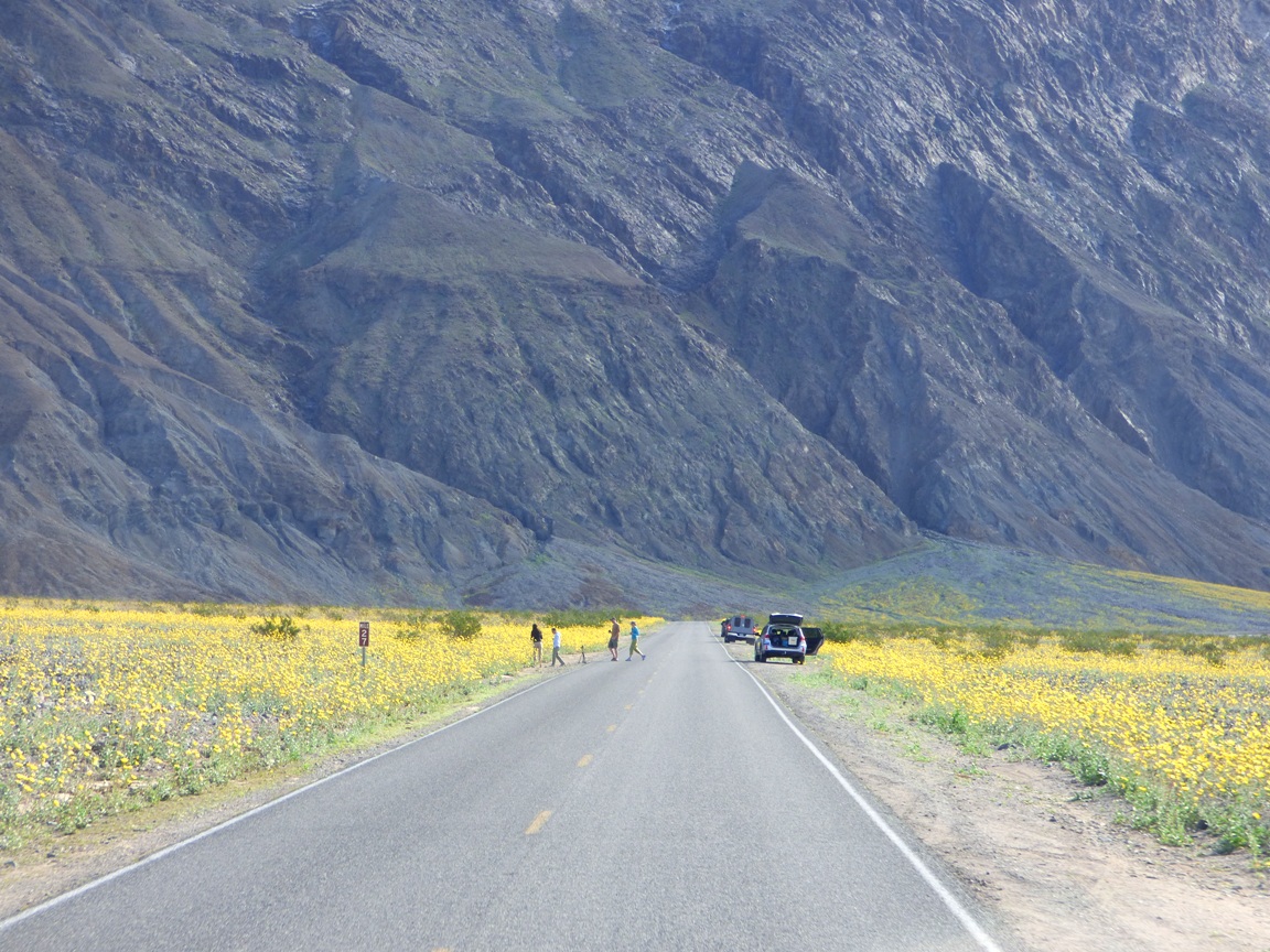
So it was that we found ourselves driving the entire length of the southern half of Death Valley so we could then make our leisurely geological explorations one after another on the way back. This plan gave us an overview of the geology of the valley, but it also gave us a dramatic view of the opening stanzas of the "superbloom". It was running weeks earlier than normal. Most years we see few, if any flowers at all. If this had been a trip with just Mrs. Geotripper and I, we probably wouldn't have even made it to the south end of the valley before sunset. We would have stopped too much! But we had geology to do, so these are drive-by shots of the flower show.
Headed south from Furnace Creek towards Badwater Basin
The graben (fault basin) of Death Valley has 11,000 feet of relief, exposing two vertical miles of the Earth's crust. Although the valley is very youthful in the geologic sense (only a few million years), erosion of the surrounding mountains has filled the fault basin with as much as 9,000 of silt, clay and salt (the basin is closed, not able to drain to the sea; much of it is below sea level).
It is so very strange to see the alluvial fans that are usually so barren turning green and yellow with life. The flowers increased in number as we moved south, I assume due to better exposures to sunlight. It seems to happen that way the few times I've seen plentiful shows of color.
It's a wondrous show, and park visitors were in sort of a trance. The kind of trance that causes them to wander aimlessly across busy highways without looking around for oncoming traffic (like heavily loaded college vans).
As we approached Shoreline Butte and the offset cinder cone, flowers covered much of the valley floor, and climbed far up the alluvial fans. Maybe flowers cover these surfaces more often in the main flower months of March and April, but I can't remember seeing them in February when we are usually there.
Shoreline Butte itself was covered with flowers. The butte is a cinder cone that has been shaped by the waves of Lake Manly, the ice age freshwater lake that once filled Death Valley 600 feet deep. The lake was present most recently about 20,000 years ago.

So, you are wondering, did we stop AT ALL where we could see some flowers up close? Why yes, yes we did. I made sure that some of our geology stops would require walking through the fields of Desert Gold, Five-Spot and Phacelia. Pictures will be coming soon!