The geology at Death Valley National Park is naked and raw. Nothing is hidden beneath a soft matte of vegetation. It's in your face, all the processes of tectonism, volcanism, erosion, and deposition. Every era and most of the epochs of the geologic time scale are represented somewhere in the boundaries of the park. Not even Grand Canyon National Park can make that claim. On the previous day we had explored the oldest rocks in the American West, the contorted metamorphic rocks of the Black Mountains and the ancient sediments of the Pahrump Group.
Our first destination on our third day of exploration in the park was the Ubehebe Craters at the north end of the valley, a place representing the opposite extreme in time. The events that took place here can be measured in just hundreds or thousands of years. On the drive there we were treated to amazing views of fault scarps, sand dunes, and alluvial fans, which formed mostly in the last few tens of thousands of years.
To arrive at Ubehebe Crater is kind of an otherworldly experience. For miles, the road has been following the broad rocky surfaces of the many alluvial fans that flank the Grapevine Mountains. The valley floor between the Cottonwoods and the Grapevines narrows and soon the alluvial fans merge in the center of the valley and in a few places the road climbs in earnest. But soon the Cottonwood Mountains come to an end, with the final ridge tapering down to the valley floor. We've reached some kind of a structural nexus. The formerly deep trough of the northern part of Death Valley seems to pinch out, and another valley merges with it from the south. The Ubehebe Craters have formed along the intersection of the faults that formed the valleys. The crustal weakness of the fault zones allowed the magma to rise from deep in the Earth almost to the surface.
It's clear when standing on the rim of Ubehebe Crater that something big happened here. This hole is a half mile across (~1 km) and around 700 feet (215 meters) deep. Whatever happened here did so more than once. There are perhaps a dozen overlapping craters, and each of them is rimmed with dozens of layers that represent numerous explosions. What in the heck happened?
The red, orange and yellow layers below the rim provide some clues. They are partly composed of alluvial fan gravels, but mostly they are fine-grained lake sediments. And they used to be saturated with groundwater. The darker rocks along the rim are composed of bits and pieces of basalt and volcanic ash. The volcanic rocks mantle several square miles around the craters (below).
The best way to see the details of Ubehebe Crater is to walk the rim (and to walk down to the bottom, but that will be a story for a different time). The gullies that have been carved into the sediments are shallow, indicating the recency of the events here.
Still the trail is steep in a few spots. It's about one and a half miles of up and down pathways leading around the rim. From high points, one can see the overlapping cones and the layers of basaltic material.
From the highest part of the rim, one can see the strong contrast between the orange and yellow sediments in the wall of Ubehebe. They mark the location of a fault line related to the Cottonwood Mountains just to the south.
It's quite a view from the top!
The only actual lava at the complex can be seen inside the crater of Little Hebe, in the picture below. Little Hebe is the remains of spatter cone that was later blown apart by the kind of explosions that formed the rest of the craters in the vicinity.
So here at Ubehebe are the ingredients for an explosive event. Saturated lake sediments, a fault line providing a conduit for magma to approach the surface, and the tendency of water under pressure to explode when it gets too hot. The Ubehebe Craters are world-class examples of maars, the craters that result from groundwater (phreatic water) flashing to steam in an explosive manner.
It must have been awe-inspiring to witness the explosions, and considering that human artifacts have been discovered underneath some of the ash deposits, there is a very good chance that people saw the event take place. Precise dating of the explosions has proven challenging, but few researchers think that the eruptions were more than 6,000 years ago, and some recent findings provide hints that the eruptions could have been only a few centuries ago...and the conditions responsible for the eruption are still present. What a spectacle it would be if it happens again!
There was one thing extraordinary about our visit last February...the air was calm! The narrow constriction at the head of the northern stretch of Death Valley causes winds to be funneled across the rim of the craters, and it's usually...um..."breezy" up there. As in barely able to stand up straight. But this day was one of the most pleasant I have ever experienced.
The display at the parking lot at Ubehebe provides a nice overview of the overlapping craters. It is easy to combine a tour of Scotty's Castle (interesting but not very geological) and Ubehebe Craters. They are only a few miles apart. Ubehebe is also the starting point for the rough road leading to Racetrack Playa and the sliding stones. Another rough road heads north across Eureka Valley to Big Pine in Owens Valley. It is another road that I intend to explore one of these days!
We got in the vans and headed south with the intention of walking into an upside-down mountain. But that will in the next post!
Friday, April 11, 2014
Monday, April 7, 2014
Out of the Valley of Death: Geology at Fifty-five
One of the first things I tell my students (and occasionally even with some success) is "don't sleep while traveling in the vans". Death Valley National Park is the largest national park in the lower 48 states, and no matter how much time one has, it's hard to take it all in. When you only have four days, it's pretty well impossible, but there is still much to see in transit between stops. On our third day out we were set to explore the northern end of Death Valley, which in a park that is mostly desert wilderness, feels even more isolated and lonely (despite the presence of Scotty's Castle up one of the side canyons).
The day started with a stunning sunrise as seen from one of the most isolated RV parks in the American west, Stovepipe Wells. The campground is literally a parking lot, but it's a parking lot with one of the most incredible views possible. The resort is situated on the distal end of the huge alluvial fan that emerges from Mosaic Canyon on Tucki Mountain, which we'll check out in a future post. The elevation is sea level, but it somehow feels higher, given the spectacular and far-ranging view.
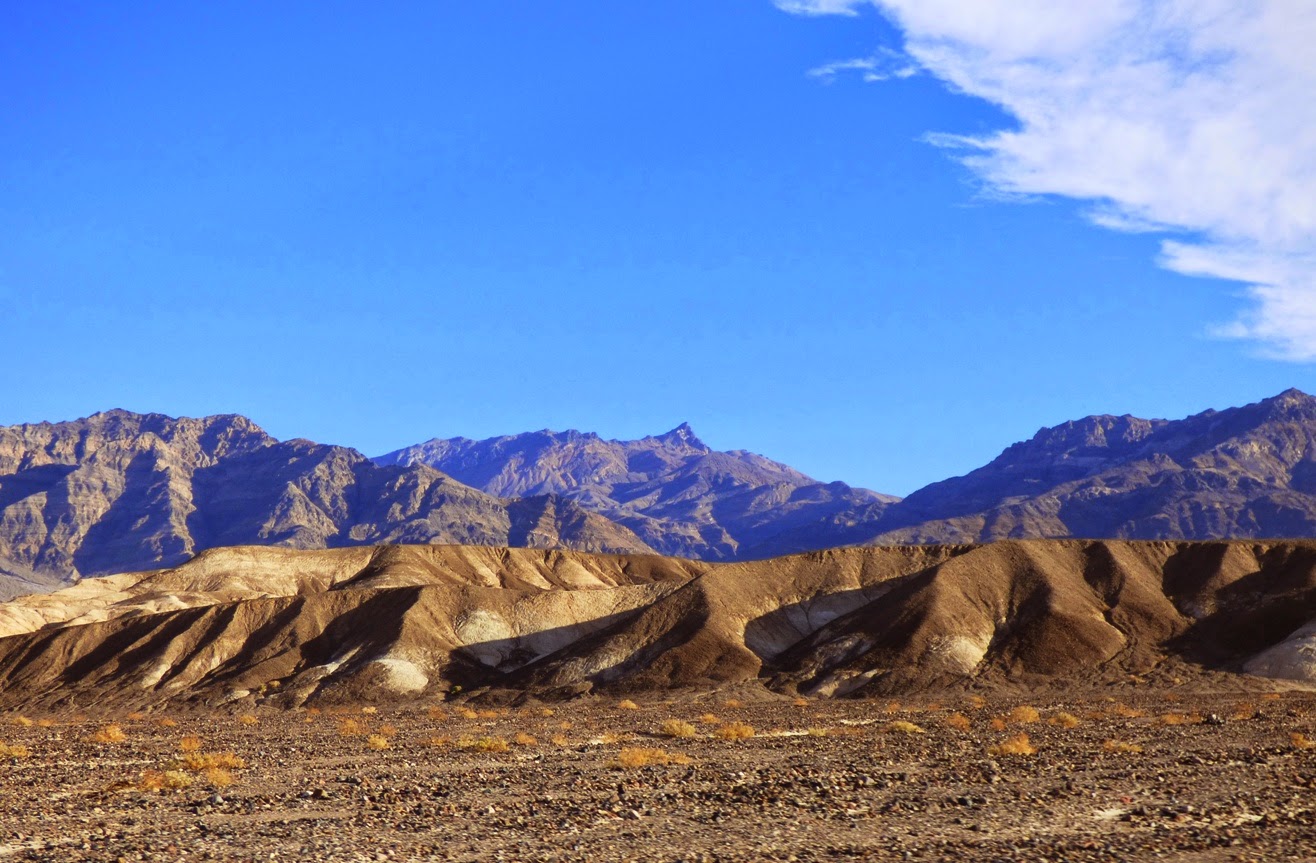
Two great desert mountain ranges form the boundaries of the northern reaches of Death Valley, the Cottonwoods on the left and the Grapevine Mountains on the right in the picture above. The mountains tower over the valley floor, reaching nearly 9,000 feet above a valley floor that is barely above sea level. The view extends thirty miles or more.
A drive north towards the end of the valley reveals a series of classic desert features, starting with the Mesquite Flat sand dunes, sometimes known as Death Valley dunes. Sand dunes are picturesque enough by themselves, but in Death Valley they have a dramatic backdrop of high barren mountains.
We raced by at 55 miles per hour ("Honest, officer!"), but cameras these days are versatile, capturing the image as if we were standing still. And this is the sort of incredible sight one could miss if one is snoring away.
The dunes have formed here because prevailing winds sweep down the northern reaches of Death Valley (and a number of destroyed tents over the years can attest to the power of these winds). The vast bulk of Tucki Mountain at the north end of the Panamint Mountains stands in the path of these winds, causing them to break up and form eddies. The sand accumulated in the region as the powerful winds lose energy and drop their load of sand and dust. They are sometimes referred to as star dunes, or modified sub-barchan dunes. Even if you've never been to Death Valley, you've probably seen these dunes anyway; they formed the backdrop for the droids lost on the planet Tatooine in the original Star Wars movie.
In the picture above, one can see the valley floor beyond the dunes is interrupted by a terrace of some sort. This is the scarp for the Furnace Creek fault zone which is one of the important structural features of the Death Valley graben.
A closer look provides a view of light-colored sedimentary rocks exposed in the face of the scarp. The fine-grained mud and silt layers are part of the Furnace Creek formation, which was deposited into a fault trough similar to present-day Death Valley, but oriented in a more northwest-southeast direction. Crustal stretching has effected the crust in the region more than once. The erosion of the Furnace Creek formation in this dry environment produces badlands topography, which we will explore in greater detail in another post.
The fault system interrupts the surface of the alluvial fan, shifting it in an right lateral direction (the rocks across the fault are displaced to the observer's right). These faults roughly parallel the San Andreas fault, which lies far to the west. The fault is presumably still active, but has not produced a major earthquake in modern times.
Another incredible sight visible from the road is the series of alluvial fans that extend from the edge of the mountains down to the valley floor. They build up as the rare but violent flash floods and mudflows carry boulders and debris across the valley floor. They have a somewhat convex slope, becoming steeper near mountain front. Death Valley is famous for the variety and number of fans it has.
The fans reveal variations in color. The darker surfaces on the fans result from desert varnish, a mixture of manganese oxides and clay that coat the exposed surfaces of the rock. It accumulates over time, and the origin is debated. Bacteria are likely involved in the process.
As we drove further north, the valley floor narrowed, and we soon reached an area where the alluvial fans from the two mountain ranges merged in the center of the valley. We were approaching the end of the Death Valley graben. In the distance we could see dark-colored rocks coating the surface of the alluvial fans. We had reached the volcanoes of Death Valley.
In the next post: the Ubehebes!
Saturday, April 5, 2014
Physics Makes for a Beautiful Moment in a Day
This post is off the beaten geo-track today, but there is a little bit of science involved. Our new Science Community Center at Modesto Junior College, which I have mentioned extensively in previous posts, has many remarkable features that represent educational opportunities. There are the big ones like the observatory and planetarium, and there are others built into the functionality of the building, like the stairwell. It is a rather grand circular stairwell that climbs four floors (three stories of labs and classrooms, and a fourth story of astronomical equipment storage and access to the rooftop observatory). Each step has one of the letters representing the DNA sequencing of a protein related to insulin, but the most dramatic aspect is the DNA double helix spiral sculpture that winds from the base of the stairwell to the very top. It is a dramatic way to get to class.
I have an early class and to beat traffic snarls I usually arrive well before 8 AM, and at that hour almost no one is in the building. It is a pleasant couple of moments to wander up the stairs in silence before the start of a busy day. Except for the bird...
For months, there has been a bird singing somewhere in the stairwell (it is an exterior stairway, so the bird isn't trapped or anything). The shape of the spiral channels the bird song and amplifies it, so that it is difficult to tell where it is coming from. I always assume that it is near the top, since that is the least-used part of the stairs, so I will sometimes take the camera and try to find out what species is making such a pretty song. I didn't find it up there, but I looked down from my spot on the fourth floor and realized the bird was way down on the first floor, perched on a support bracket for the DNA spiral.
There weren't any exotic species hiding out on our stairwell, it was a common House Finch (Carpodacus mexicanus). If I were any kind of real birder, I would have known the song because these birds are at the feeder in my backyard every day. But take the simple song of a finch and put it into an acoustical sound chamber, and the song becomes a symphony. It's a nice way to begin a chaotic day.
Friday, April 4, 2014
DEATH, FIRE, EXPLOSIONS, END OF CIVILIZATION! YELLOWSTONE! OMG! Um, about that...
"Bison and many other animals are leaving Yellowstone in droves, and its (sic)prompting theories that minor earthquakes in the area could soon set off the Yellowstone Super Volcano." Source: click here
How many things can be wrong in one sentence? I count at least three or four. To begin with, the viral video that has the rumor mill going crazy apparently is showing a herd of bison rushing into Yellowstone National Park, not out. And I wouldn't be surprised that animals are leaving for lower elevations in any case. There is a decided lack of food higher up. They do it every winter.
Then, the word "theories" gets casually tossed into the mix. Speculation on the basis of very limited (or absolutely no) evidence is not a theory (a model or idea confirmed by extensive testing). The speculation in the sentence above doesn't even rise to the level of an hypothesis, which nearly all school children call an "educated guess". "Hypothesis" is reserved for ideas and models that are plausible.
The minor earthquake was a magnitude 4.7 event. The largest in thirty years. So what? It's still a minor earthquake. There are hundreds or thousands of earthquakes in Yellowstone every year, and the caldera hasn't exploded. There was a quake with a magnitude of 7.3-7.5 back in 1959. That quake, which killed 28 people was thousands of times more powerful than the quake last week. Why didn't the caldera explode back then?
It comes down to ignorance of basic geologic principles on the part of journalists and the fear-mongers on the web. Having a little bit of knowledge is sometimes as damaging as having no knowledge. People have been told by cable channel documentaries over and over that Yellowstone is a "supervolcano", which was never a geologist's term. They pick up that there was a truly colossal eruption 2.1 million years ago, another 1.3 million years ago and another 640,000 years ago. OMG it's a pattern and we're all going to die! Next week!
The gentle fact is that Yellowstone has not had a volcanic eruption in 70,000 years. There is indeed a large body of molten magma beneath the park, but it has been there for millions of years, and there are currently no signs of unusual activity. From studies of calderas around the world, it is clear that many warning signs taking place over centuries would give humans plenty of time to figure out how to deal with the eventuality of a major eruption.
There are many things to worry about in the world these days, but a gigantic eruption at Yellowstone is not one that I lose sleep over. When you read someone's frantic post about "the BIG ONE" shaking up Southern California or supervolcanoes destroying civilization, make use of one of the most powerful human tools ever invented. Take to the internet, the greatest repository of human knowledge ever constructed, and investigate. Don't seek out the idiots who post rumors and innuendo. Find out what the real geologists are saying before hitting that "share" button. Don't get Snoped by your more intelligent friends. It's really embarrassing.
And that goes double for "journalists". What you have done with is non-story is irresponsible. At the very least, read an analysis by a responsible blogging expert like Erik Klemetti at Wired before writing anything on your own.
How many things can be wrong in one sentence? I count at least three or four. To begin with, the viral video that has the rumor mill going crazy apparently is showing a herd of bison rushing into Yellowstone National Park, not out. And I wouldn't be surprised that animals are leaving for lower elevations in any case. There is a decided lack of food higher up. They do it every winter.
Then, the word "theories" gets casually tossed into the mix. Speculation on the basis of very limited (or absolutely no) evidence is not a theory (a model or idea confirmed by extensive testing). The speculation in the sentence above doesn't even rise to the level of an hypothesis, which nearly all school children call an "educated guess". "Hypothesis" is reserved for ideas and models that are plausible.
The minor earthquake was a magnitude 4.7 event. The largest in thirty years. So what? It's still a minor earthquake. There are hundreds or thousands of earthquakes in Yellowstone every year, and the caldera hasn't exploded. There was a quake with a magnitude of 7.3-7.5 back in 1959. That quake, which killed 28 people was thousands of times more powerful than the quake last week. Why didn't the caldera explode back then?
It comes down to ignorance of basic geologic principles on the part of journalists and the fear-mongers on the web. Having a little bit of knowledge is sometimes as damaging as having no knowledge. People have been told by cable channel documentaries over and over that Yellowstone is a "supervolcano", which was never a geologist's term. They pick up that there was a truly colossal eruption 2.1 million years ago, another 1.3 million years ago and another 640,000 years ago. OMG it's a pattern and we're all going to die! Next week!
The gentle fact is that Yellowstone has not had a volcanic eruption in 70,000 years. There is indeed a large body of molten magma beneath the park, but it has been there for millions of years, and there are currently no signs of unusual activity. From studies of calderas around the world, it is clear that many warning signs taking place over centuries would give humans plenty of time to figure out how to deal with the eventuality of a major eruption.
There are many things to worry about in the world these days, but a gigantic eruption at Yellowstone is not one that I lose sleep over. When you read someone's frantic post about "the BIG ONE" shaking up Southern California or supervolcanoes destroying civilization, make use of one of the most powerful human tools ever invented. Take to the internet, the greatest repository of human knowledge ever constructed, and investigate. Don't seek out the idiots who post rumors and innuendo. Find out what the real geologists are saying before hitting that "share" button. Don't get Snoped by your more intelligent friends. It's really embarrassing.
And that goes double for "journalists". What you have done with is non-story is irresponsible. At the very least, read an analysis by a responsible blogging expert like Erik Klemetti at Wired before writing anything on your own.
Thursday, April 3, 2014
And They Became Gods in the Classroom: A Different Use for Monopoly Houses
It's getting well into the semester, and it's starting to wear on the students. A lot of them work at awful jobs which keeps them convinced that they need to do well in school so they can get a career doing something they enjoy. Some of them look a bit tired, as evidenced by the fact that their faces are planted on their desks, snoring. So what can you do in a geology lab to wake them up a bit? Let them play god!
Stream tables are the grown-up college equivalent of a sand box and hose. They allow students to simulate various hydrological situations, producing river deltas, alluvial fans, river channels and meanders, and shoreline wave processes. They set up a situation, a river channel or a dam, and then they turn on the pump and let the water run for awhile, observing the changes that take place. For some reason, the addition of Monopoly houses and hotels takes it to a new level. The students become capricious gods, determining the fates of their subjects on a whim, a flood here, a wild tsunami there.
I would hardly have noticed or commented today, but for once I set up a meander pattern in the sand and wandered away for a few hours with the water running. The stream did what streams will, and produced a sweet little meander cutoff , destroying the little Monopoly village in the process. It was sad for the Monopolians, but a great educational moment for the gods of the classroom!
Monopoly houses and hotels for years have taught our children to become corrupt hedge fund managers and criminal bank presidents (didn't you cheat too, or was it just me?). Why not put them to work to teach the dangers of ignoring geology too?
The stream table, by the way, is one of the best ways to detect a potential geology major. They will be hypnotized and work with the thing for hours!
Labels:
geology ed,
meander cutoff,
Monopoly houses,
stream table
Wednesday, April 2, 2014
A Chance to See the Most Advanced Planetarium Star Projector in the Country! Friday, April 4 at Modesto Junior College
For those of you who live in Central California within driving distance of Modesto:
If you follow my blog at all, you know that I have been enthusiastically describing the new Science Community Center along with the Great Valley Museum and Planetarium at Modesto Junior College. Many of you have been wondering when you would have a chance to see the planetarium (with the most sophisticated star projector in the country) in action. That time has come! This Friday the Great Valley Museum holding a major fundraiser, and will be offering four planetarium shows as well as tours of the nearly completed Great Valley Museum, including demonstrations of the Science on a Sphere. This is worth a bit of a drive if you are anywhere near, and the proceeds will support the Great Valley Museum in this, their most important year ever as they open up the new facility in a few short months. Come and join us! I'll be there, and will gladly offer tours of the geology department upstairs as well.
Oh no, it's Jar Jar Binks! No, It's Far More Special Than That...
Omigod! Somebody caught Jar Jar Binks! Okay, not really. But what the heck is this thing?
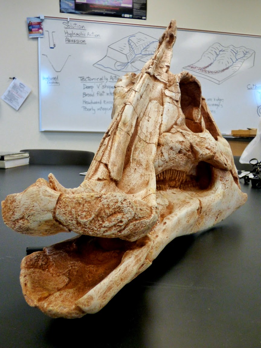
Say hello to Saurolophus, our home-grown California dinosaur! It is the last of the new teaching materials that we were able to purchase as part of renewing the teaching of science at Modesto Junior College. We ordered it months ago, but I guess there was a backlog of skull orders or something. It was like Christmas opening the box this morning.
Being last isn't what made it special. We have half a million people in our county, and I'm willing to bet that 99% of them don't know what it is or why it's important to them. Only one person got to be the first to find a dinosaur bone in California, and that was 17-year-old Al Bennison in 1937. He was exploring Del Puerto Canyon in the Coast Ranges along the western part of Stanislaus County looking for shell fossils when he found bones scattered on a slope. He showed them to his science teacher who reported them to the paleontologists at U.C. Berkeley. It was the first dinosaur ever found in our state. Bennison went on to a career in geology, and a few decades later discovered the most complete mosasaur skull ever found in California (see below). The mosasaur species even bears his name.
The Saurolophus was one of the last dinosaurs that ever lived on our planet, one the last groups in existence when the gigantic asteroid hit the planet (or when the volcanoes blew, or whatever else did them in). They lived in the latest part of the Cretaceous Period, which is well represented by sedimentary rocks in our region. The rocks are marine in origin, which tend not to be good places to search for dinosaurs, but sometimes a carcass would float out to sea.
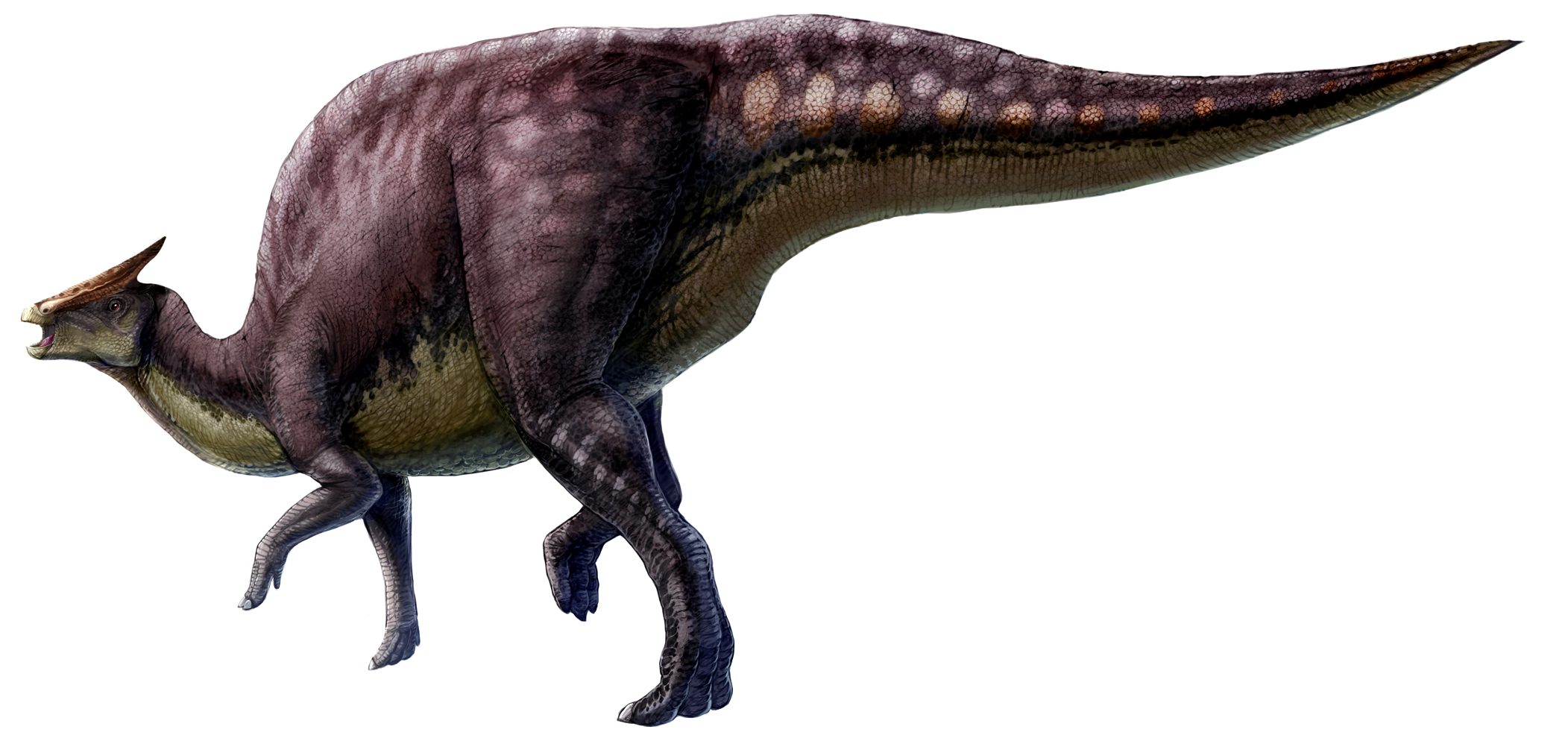
![]() |
| Source: http://en.wikipedia.org/wiki/Saurolophus |
The creatures were gigantic, on the order of thirty feet long, weighing several tons. They were plant-eaters, with teeth well-adapted to grinding twigs and leaves. Whether they swam or not has been a topic of discussion and debate. Some argue that they had few other defenses from predators, so that swimming was necessary to escape from being eaten. Others suggest that they lived in herds that provided protection.
Our skull collection is now a powerful tool for teaching the students in our region about the heritage of the land that they live on. In the picture above, one can compare the Cretaceous plant-eater with the Short-faced Bear skull, which lived in our area during the Ice Ages during the last two million years. It may have been the single largest mammalian land predator that ever lived, with a standing height of 11 feet. It would have made a grizzly bear look small in comparison.
The picture above shows our other recent arrival, the Mosasaur, similar to the one found by Al Bennison during the 1950s in the Coast Ranges just south of our county. It was not a dinosaur but was instead a seagoing reptile from the Cretaceous Period that may have snacked on sharks. It was around thirty feet long. It is probably the most formidable predator ever to inhabit our region.
To give a sense of scale, we have the Mosasaur nosing an Ice Age Sabertooth Cat skull (the cats weighed 700 pounds), and one of those wimps of the early Cretaceous, Velociraptor (which came out of Mongolia, not the Americas).
Dinosaurs certainly capture the imagination of our children (and not a few of our adults), and it is a good thing for our students to know that our county played an important part in the paleontological discoveries in our state. When students realize that one of their own (however long ago) made an important find, they also can visualize themselves as a paleontologist or geologist making important contributions to science.
![]() |
| Source: http://upload.wikimedia.org/wikipedia/commons/4/4b/Saurolophus_scalation.png |
For the best source of information on dinosaurs and other Mesozoic reptiles of California, check out this book by Richard Hilton of Sierra College. It's the best resource out there for our state.
Subscribe to:
Posts (Atom)