Monday, September 1, 2008

The Colorado Plateau Story: the real Jurassic Parks


Today we make a return to our series on the geologic story of the Colorado Plateau. The Mesozoic Era left a stunning variety of rocks across the region. The Triassic story, with the Moenkopi and Chinle formations has been told, but today we explore a few of the real Jurassic Parks, the ones in which the scenery is formed by rocks laid down during the Jurassic Period. The scenery makers today are the Wingate Sandstone and the Kayenta Formation, which can be seen especially well in three parks: Capitol Reef National Park, Colorado National Monument, and Vermilion Cliffs National Monument. The Wingate appears in a prior post involving Canyonlands National Park. I notice that Geology Happens is a fan of the Wingate as well.


The Wingate Sandstone formed in early Jurassic time as sand dunes migrated across the increasingly arid region. The layer tends to be bright orange-red, and has the crossbedded structure typical of rocks formed from dunes. Dune environments are not generally conducive to the preservation of fossil material, but reptile trackways are occasionally discovered.

The Kayenta Formation lies above the Wingate and is most often exposed as a series of colorful ledges and slopes. It formed as a series of rivers flowed across the dune fields from the Wingate deserts. It contains numerous trackways of dinosaurs and other reptiles. Fairly easy to erode, it is not well-known as a scenery-former but it plays a critical part in the dramatic scenery at Zion National Park (to be covered in a near-future post).


Colorado National Monument lies just south of Grand Junction and Fruita, Colorado (the top picture, and this one from a previous post). It is one of our lesser-known parks, but is well worth a visit if you travel through the region. The park preserves a spectacular eroded monocline, which is a folded sequence of rocks where the layers are horizontal at either side of the flexure, much like a rug thrown over a stairstep. A marvelous paved road snakes in and out of canyons, mostly within the Kayenta Formation just above the Wingate cliffs. And the Wingate cliffs are incredible, a sheer drop just a few steps beyond the edge of the road. Although such roads are not being built in national parks today as a matter of preservation policy, I have to appreciate the effort that went into the construction of this one. There are many, many wonderful overlooks, a modest campground, and a decent visitor center. Lots of services are available in the nearby towns. Some very important dinosaur discoveries were made just outside the park (in younger formations), and signs point to the quarry sites.


Capitol Reef National Park is illustrated in the second picture above, and in the uranium post a few days ago. The park lies in the practically unhabited region of south-central Utah (Torrey and Hanksville are the main urban centers with a combined population of about 500). The park preserves another spectacular monocline, the Waterpocket Fold, that runs nearly 100 miles in a north-south direction. The "reef"of the park name refers to the difficulty settlers had in crossing the rugged eroded rocks of the monocline. Even today, a single paved highway crosses the structure, and a few unpaved gravel roads. A Mormon settlement (Fruita) was established here in the 1800's, and the fruit orchards are still maintained by the park service and volunteers. A favorite park activity is picking cherries and other fruits in season. The region was utilized in earlier times by the Fremont people, a lesser known culture than the Ancestral Puebloans of Mesa Verde and other areas to the south.


Vermilion Cliffs National Monument is at the same time one of the more familiar and least-visited monuments in the United States. The interior of the park is rarely visited, and there are few facilities of any sort for tourists; a true wilderness park. On the other hand, hundreds of thousands, maybe millions of people drive past the park on Highway 89 from Jacob Lake to Lees Ferry and Navajo Bridge, where the Vermilion Cliffs cannot be missed or ignored. The sheer cliffs rise 3,000 feet above the highway, and are just beautiful. California Condors have been re-introduced into the region, and the lucky traveler might just catch a glimpse.


Even with my more or less yearly visits to the region, I have never been in the monument, with one huge exception. Most of the park is a vast high plateau, but the northeast portion of the monument is dissected by an incredible gorge carved by the Paria River. The headwaters of the Paria lie to the north at Bryce Canyon National Park. Where the river reaches the Navajo Sandstone, it has cut an extremely deep canyon, the Narrows, with a major tributary, Buckskin Gulch, which is one of the longest deepest slot canyons in all of the Colorado Plateau.


I was in the Boy Scouts, and one of the last trips I took as a scout was a six-day backpack down the Paria River to Lees Ferry. It was one of the greatest adventures of my life, and probably had a lot to do with my eventual choice to become a geologist. Just the same, I knew little of geology at the time, and I would dearly love to repeat the adventure one day. I will search for my pictures of the event, but I had a camera I had no idea how to use, so the pictures that came out at all were over- and under-exposed. Plus, I dropped the camera in quicksand, and it was never the same after that (i.e. it never worked again at all).


Have you ever been in real quicksand? It's not very much like Hollywood quicksand, but it was an invigorating experience sinking to my knees most unexpectedly. I had walked across about 50 feet of it before actually breaking through, and it was lots of fun getting back out!

Sunday, August 31, 2008

A Brief Foray into Politics (to be continued later?)


What do the major party candidates think about science?

Much is being made of the qualifications of the Republican pick for vice-president, or the relative lack thereof. In the area of science, the only statements in the media reflect Palin's credentials as a conservative Christian who is a creationist, who believes that creationism (or the barely-disguised intelligent design) should be taught in public classrooms. Defenders say that her apparently single public comment has been taken out of context (so out of fairness I link to a site I rarely agree with, here). Other reports detail her belief that global warming is not caused by humans, and that polar bears are not threatened, and therefore do not deserve protection under the Endangered Species Act.

It is a bit harder to pin down McCain's policy on creationism; he has been quoted on both sides of the issue, and he spoke last year at the Discovery Institute, the source of intelligent design "theory".


Science should be a critical issue in this election. Many of our most pressing national issues require a clear understanding of how science works, and how we as a country must respond: global warming, science education, energy issues, nuclear issues, mining issues, and many more. A recognition of the value of science and education is noticiably missing from the national discourse. Scientists and Engineers for America has a nice rundown on the science policies of the two major party candidates.


Check it out...

Today's picture is Lake Mary in Glacier National Park. A hundred or so years ago there were 150 glaciers in the park. Now there are 27. They are expected to be gone in the next thirty years due to global warming.

Nearly immediate update: Andrew at About.com Geology has a post on the subject from a few hours ahead of me. Check it out here.


Second immediate update: Arizona Geology had the subject up yesterday

Wednesday, August 27, 2008

Accretionary Wedge Carnival: A Late Arrival and Nearly Lost Connections


This month's Accretionary Wedge Carnival is (was) hosted by Callan Bentley at NOVAgeoblog, and is on the rather wide open topic of geologic connections. I'm a little late, having been distracted by the beginning of a new semester: those first hours of excitement, expectation and enthusiasm, followed by fifteen weeks of perceived pain and suffering (at least that is what MY students say).

The start of a new teaching year gave me the idea for my contribution to the Wedge this time around. I am a teacher, I was taught by a number of excellent teachers, and they in turn had teachers. I was vaguely aware that some of my professors studied under some illustrious individuals, and I even met a few of them, but I had never really considered looking into the academic lineage of those who taught me geology. I was in for a few surprises.

I found out right away that lots of mathematicians, chemists and physicists have an academic lineage on the web, but I couldn't locate many for geologists (not that I spent hours on the subject or anything). But there was enough to construct an academic lineage (sort of) for myself going back to the late 1700's. There may be a few mistakes here, and apparently a lineage is supposed to follow the thesis advisors, but I'm gonna cheat just a little (a lot) on the rules, so here we go...

I got my bachelor's degree in geology at Pomona College where I studied under three fine professors, Dr. Donald Zenger, Dr. D.B. McIntyre, and Dr. A.K. Baird. I did my senior thesis with Dr. Baird. He passed away a number of years ago, far too young, but he did a great deal of research on the Southern California Batholith, and worked with Mars Viking Project in the 1970's.

To the best of my knowledge, Dr. Baird studied at Pomona College under the guidance of Dr. A.O. "Woody" Woodford (1890-1990), who founded the department in 1922, and taught geology to the likes of Roger Revelle (mentioned in "Inconvenient Truth" for his global warming work; Revelle College at UCSD is named for him), Charles Anderson (former chief geologist of the U.S. Geological Survey), Mason Hill (San Andreas fault and oil on the north slope of Alaska), Rollin Eckis (geologist and former chairman of ARCO), and John Shelton, along with many, many others. Woody maintained an office at Pomona College after his retirement in 1955, and continued his research through the 1980's. He was a familiar sight in the halls when I was a student there.

Along with his other professors, Woody studied at U.C. Berkeley under Andrew C. Lawson (1861-1952), a giant in the history of geologic research in both the Canadian Shield and in California. Lawson designed much of the geology program at Berkeley, and made many pioneering studies in the Coast Ranges and Sierra Nevada, and was the chairman of the State Earthquake Investigation Commission that produced the pivotal report on the great 1906 San Francisco Earthquake.

Andrew came to Berkeley at the invitation of Joseph LeConte (1823-1901), who was the first geologist there. He is known for many contributions to the field of paleontology, but he is perhaps best known today for his explorations of the Sierra Nevada, and his association with John Muir and the founding of the Sierra Club.

While at Harvard University, LeConte studied under Louis Agassiz (1807-1873), who is well known for his work in paleontology, but is celebrated in geology because of his research in glaciology, and his proposal that northern Europe and North America had once been covered by thick blankets of ice.


Agassiz was introduced to geology by Alexander von Humboldt (1768-1859) and to zoology by Georges Cuvier (1769-1832). Humboldt traveled widely, especially in South America and Europe, and originally proposed the Jurassic as a name for Mesozoic period represented by limestones in the Jura Mountains. He was one of the first to suggest that Africa and South America might have been connected to each other in the past.

Baron Georges Léopold Chrétien Frédéric Dagobert Cuvier was one of the earliest paleontologists and was one of the first to recognize that extinctions had taken place in the Earth's past. He was also a pioneer in the field of comparative anatomy. He is also famous for his belief in catastrophism, which stood in contrast to uniformitarianism, one of the guiding principles of science today.

So there it is...a series of connections that reaches back two centuries that led to a lanky slacker at Pomona College who later lucked into being a teacher at a modest community college in central California. It is not the lineage that leads to inspiration, of course. The teacher who gave me the desire to know more about the earth more than any other didn't have a lineage that I can track down on the internet, but I know he loved the science and inspired many of us to become geologists. He's in the picture above, but I haven't asked his permission to give his name, so I won't, but I want to thank him for his contribution to the field, and to let him know that I hope to carry on his tradition of excellence in my own career.

Friday, August 22, 2008

Time Beyond Imagining - A Brief History of the Colorado Plateau: The Real Jurassic Parks


As we move forward in time, we reach the geologic period called the Jurassic, one of the few units of the geologic time scale that is familiar to many laypeople. We have Steven Speilberg and Michael Crichton to thank for that, and yes, dinosaurs rose to prominence in the terrestrial landscape, but lots more was going on as well, including a lot of interesting non-dinosaurs, including our own small furry predecessors creeping about in the underbrush (the mammals first appeared in the late Triassic, about the same time as the first dinosaurs).

So what are the real Jurassic Parks? In the movies, the park was an island populated by reconstituted dinosaurs that ate people and each other. The Jurassic Parks of the Colorado Plateau are the ones in which the most dramatic scenery is provided by Jurassic-aged rocks, which include the Wingate, Kayenta, Navajo, Carmel, Entrada, Summerville, and Morrison formations. The parks include the familiar Zion, Arches, Capitol Reef, and Canyonlands national parks, and the less familiar Grand Staircase-Escalante, Navajo, Rainbow Bridge, Vermilion Cliffs, and Colorado national monuments. Notable state parks include Kodachrome, Goblin Valley and Dead Horse Point, all in Utah. Many of the dramatic cliffs included within the Glen Canyon National Recreation Area are also made of Jurassic rocks. And let us not forget the actual Dinosaur National Monument, the one that actually has dinosaurs (although at last report, they did not eat park visitors).

Today's photos include a parting shot of the Chinle Formation at Petrified Forest National Park, simply because I came across it in a lost file and liked it, and a picture from near the head of the Schafer Trail in Canyonlands National Park, which is cutting across ledges of the Kayenta Formation as it prepares to plunge down the Wingate cliffs to the White Rim, discussed in a previous post.

The Schafer Trail leads to the White Rim Trail, which winds for a hundred miles or so through the heart of Canyonlands National Park. It is one of the life-list goals that I haven't accomplished yet. It pretty much requires at least two days to travel, and three or four days by bike. The Schafer Trail was originally carved by cattlemen and improved by uranium miners (they worked pretty hard...).

So, why the dramatic colorful cliffs? Something important had changed, causing the Triassic floodplains to disappear. The silts and clays and river channels were replaced by desert dune sands, which quite often form prominent cliffs when hardened into solid rock. The deserts formed because Pangea had begun to break apart, and North America was now moving northwest, into the subtropics where the prevailing air circulation results in dry conditions. We see a similar situation in the Middle East and Sahara Deserts today.

Wednesday, August 20, 2008

Leetso, the Yellow Monster


How do you tell someone that the cigarettes are going to kill them? Even today, after 30-40 years of clear connections between smoking and cancer, people don't take the warnings seriously. Why? I don't smoke, and I never understood the intensity of the addiction. But part of it is the long delay between the act and the consequence. Hit someone on the head with a stick, and they immediately understand that sticks hurt. But if they don't feel the pain until 30 years later, well....

I've held a chunk of pure uranium in my hand, and it is simply a piece of metal, and not necessarily dangerous outside the body. But... the unstable isotopes do produce radioactive byproducts, including radon gas. And those byproducts are dangerous, especially in human lungs. But unfortunately, like cigarettes, the effects may not show up for a decade or more following exposure. The longer the exposure, the more likely the bad consequences, mainly lung cancer.

The miners in the 1950's worked in poorly ventilated shafts in which radon accumulated at thousands of times the currently established safe levels. They worked in ignorance, because although the danger was suspected decades prior, mine operators and the federal government couldn't be bothered to warn them or provide adequate ventilation. Cold War security concerns trumped safety concerns (it wasn't just the mines; the effects of atomic bomb tests in the southwest have been well-established), and anyway lots of money was being made.

Just like cigarettes, the consequences didn't appear for years. But by the 1960's the miners were starting to fall ill and die from lung diseases. Hundreds, who knows, maybe thousands were sickened and killed. But it didn't stop with the miners.

Thousands of mines produced millions of tons of tailings contaminated with uranium. Few regulations existed to keep the tailings from leaking into nearby rivers and watercourses, or from leaching into the groundwater, and even fewer to prevent dust from blowing about. Houses, schools and other buildings were built on contaminated soils. The full effects are only beginning to be recognized

One of the most egregious pollution problems involved Charlie Steen. Impatient with the distances to government uranium mills and the transportation costs involved, Steen's company constructed the Atlas Uranium Mill in Moab literally on the banks of the Colorado River. The mill closed decades ago but the tailings leached and leaked into the Colorado River for years. At this time, reparation work is being done and the tailings are being removed to a safe site 30 or 40 miles away. I am sure they are doing a great job...

So, you've never lived on the plateau, you weren't a miner, so "why, me worry?". Leaving aside the whole contamination of the Colorado River issue, there are unexpected connections. For quite a few years I knew there was some kind of an old mine right on the south rim of the Grand Canyon a short distance west from the El Tovar and Bright Angel Lodge. The rim trail, hiked by thousands every year, takes a long detour around the fenced 10-acre site. I always assumed it was another old copper mine, like others I had seen in my travels. It is and it isn't. It is the Orphan Mine, a turn-of-the-century copper mine in which uranium was later discovered. The uranium was mined from 1953 to 1972. Extraction rights were actually retained as late as 1988 (see the hyperlink above). The site is contaminated with ores and waste. I've heard that the dust-covered miners knocked off work and enjoyed a meal at the lodge before heading home, leading to speculation that geiger counters would have been beeping inside the restaurant.

The mine has been shut down for 35 years, so whatever...except for the headline I saw this week, via Arizona Geology. The problem at Grand Canyon National Park is that the park boundary is only a short distance south of the rim. The rest is national forest or Bureau of Land Management and is open to mining. Uranium prices are very high, and interest has been building in a renewal of mining. Thousands of mining claims are being established, and the BLM continues to process requests despite a congressional moratorium; the agency doesn’t consider the Congressional vote valid.

At least the Navajo people, as a sovereign government, have the right to block renewed mining. As Kim noted in the comments on my last post, they have placed a moratorium on new development on their lands, and work continues, however slowly, to heal their lands of the damaged caused by Leetso, the Yellow Monster.

And what are we gonna do with all of the used reactor waste? Who knows. Just remember, like our politicians tell us, that nuclear power is our "clean" bridge to a bright energy future...

Sunday, August 17, 2008

Time Beyond Imagining - A Brief History of the Colorado Plateau: This Yellow is NOT Mellow


The Triassic-aged Chinle Formation is well known for a particular resource, and the heritage of the extraction of that resource is a story of tragedy and appalling governmental indifference to the safety and health of its citizens. It is known to the Diné (the Navajo people) as Leetso, the Yellow Monster.

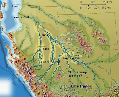
The base layer of the Chinle in many places is a conglomerate/sandstone unit called the Shinarump Member. It was laid down in streams and channels cut into a surface of the underlying Moenkopi Formation. Groundwater could flow freely through the unit, and it carried dissolved metals. When the metals encountered carbon rich fragments like wood and plant fossils, the metals precipitated out, forming a yellow powdery mineral called carnotite, or a dark oxide mineral called pitchblende. These minerals are the primary ores for uranium.

Uranium has had a long and spotty history. It has the familiar and well-known uses as a source of energy, and in bombs. It has been used as a color source in glazing and glass-making, producing intense green and orange hues, and was even touted many years ago as a health aid. To geologists, uranium is an incredibly useful tool; because it is radioactive, it decays at an extremely regular rate, giving us an accurate method to date the formation of many kinds of igneous rocks (the more familiar term carbon-dating refers to a method of dating archaeological artifacts composed of wood, shell or bone; uranium age dating is far more versatile and useful for geological research).

Uranium had been found on the Colorado Plateau prior to World War I, mostly as a by-product of vanadium mining and the search for radium. Today's pictures are of the Oyler Mine in Capitol Reef National Park, which was active in the early 1900's with little recorded production. It is a real attention-getter with my students, because we carry a geiger counter when we approach the mine, and it starts beeping within 30 feet or so of the mine openings.

The discovery of atomic fission and the development of the atomic bomb in World War II drove the renewed search for uranium on the plateau. The United States was importing something like 90% from foreign sources, and the government deemed it to be a critical resource. In the aftermath of the war, the Atomic Energy Commission sponsored a uranium rush, providing maps, roads, and financial incentives to anyone willing to explore the wildlands of plateau to find the ores. It was a hard and dangerous existence, but several thousand people heeded the call and fanned out over the countryside looking for the elusive yellow powder.

One of those involved with the search was Charles Steen. A geologist with a "problem with authority", he arrived in Utah in 1949 with a wife and three small children after a truncated career in the oil industry. Dirt poor, he couldn't even afford a geiger counter. He mortgaged his mother's house to purchase a drilling rig, and using his geological training, he determined that ores might exist in the Lisbon Valley near the Colorado/Utah border just a few dozen feet below the surface. As the story goes, he broke the drill rig short of his goal, but he later found that the drill chips stored in his jeep turned out to be nearly pure uranium ore. In the blink of an eye, he was a rich man and uranium mania swept across the plateau (I suggest the book Uranium Frenzy by Raye Ringholz for a great narrative on the boom).

Thousands of people flooded into the region, changing it forever. More than a thousand mines were drilled, uranium processing facilities were built, bombs were made and exploded, and a vast amount of money was made (and lost). America had entered the atomic age, with her bombs a hedge against the frightening communist threat (except they got the bomb too), and the promise of safe, clean atomic energy so cheap it wouldn't have to be metered.

But as always seems to be true, the dreams didn't exactly match the reality.

Tsoodzil, near Grants, New Mexico, is one of the four sacred mountains of the Navajo people. The Europeans called it Mt. Taylor. One of the biggest uranium discoveries took place on and around the mountain, and one of the largest underground mining operations plumbed the depths beneath the mountain. No one consulted with the Navajo or any other Indian nations over possible cultural objections, because, of course, national security overrode all other concerns. Thousands of miners labored under the ground in the poorly ventilated tunnels. But, there was money to be made after all. But an evil had been released, and few of the people involved would be aware of it until it was too late.

Representatives of the Navajo Nation have this to say about uranium:

When an evil act is done, many monsters are born of that act. Our traditions tell us that the monsters of the past were created when people transgressed, when they committed evil. The other monsters are a war industry built on disrespect for human life, and a modern international energy industry built on disrespect for both other humans and the environment. Those monsters feed on power, political power as well as nuclear power. Their nourishment comes from disrespect for the five-fingered People (i.e., humans) and for Mother Earth.

Friday, August 15, 2008

Time Beyond Imagining - A Brief History of the Colorado Plateau: Ash and Wood


Continuing on our journey through time on the Colorado Plateau, we explore the Chinle Formation, one of the most diverse and distinctive layers in the region. It forms most of the scenery at Petrified Forest National Park, and is ubiquitous in such widespread locales as Capitol Reef and Canyonlands National Parks, Grand Staircase-Escalante National Monument, Zion National Park, and Glen Canyon National Recreation Area. The formation was laid down during the late Triassic, a time of huge changes in the world, especially in the biosphere. It was the age of the earliest dinosaurs, but the world was populated by a host of unusual reptiles and amphibians. The Chinle was an ideal environment for preserving fossils: the shales, siltstones, sandstones and conglomerates were laid down in river floodplains and channels. The headwaters of the rivers were mountains far to the southeast, but a chain of volcanoes to the southwest provided vast amounts of ash to the landscape.

When the Chinle is sandwiched between cliff-forming layers, it forms distinctive lavender and red slopes, but is often covered by debris from the cliffs above. In parts of the Navajo Reservation and the region around Holbrook (known popularly as the Painted Desert), the Chinle forms spectacular badlands topography. The bright colors result from the oxidation of various metal ions in the clay layers, especially iron.


Map courtesy of Ron Blakey of Northern Arizona University

The trees of the Petrified Forest are the most famous fossils of the Chinle. Most of the trees accumulated as logjams in the large rivers that flowed northwest through the region. Some of the logs are as much as 100 feet long. Once buried in mud and ash, silica dissolved from the surrounding rock filled cell spaces or replaced the wood material entirely. Once again, metal oxides provide the striking colors, primarily reds and yellows.

It is pretty amazing that any petrified wood remains in the park. In the early part of the century, trains would stop nearby so people could carry off samples. At least one mining venture sought to grind the wood up into abrasives. Every year park visitors carry off more, but I notice that the National Park Service doesn't discourage the rumor that bad luck befalls those who steal wood. Ironically, people pay huge fines for stealing something that can be picked up free and legally outside the park. Some of the local rock shops even give away free samples.

The Chinle Formation also contains a rich vertebrate fossil record. Phytosaurs and metoposaurs are commonly found, as well as Coelophysis, one of the earliest carnivorous dinosaurs. Hundreds of their remains have been discovered at Ghost Ranch in New Mexico. Plateosaurus and Chindesaurus are two relatively small ancestors of the giant sauropods that dominated the later Mesozoic. A rich assemblage of other fauna and flora have been discovered. A nice review of the paleontology of the Chinle can be found here.

The Chinle has another heritage, a far more insidious one...our next post will explore this in more detail.