Showing posts with label Chinle Formation. Show all posts

Tuesday, May 24, 2016

Airliner Chronicles: Stuck on a Plane with a Proselytizer...

And really, I felt sorry for the poor guy who was stuck sitting with me on the plane flight from St. Louis to LAX. Oh, I wasn't trying to convert the poor guy into some religion. No, he got the full-court press from me about the importance of understanding what was going on 35,000 feet below us on the ground. He was being proselytized into the world of geology.

People who fly a lot for whatever region may be forgiven for not paying attention to the grand panorama unfolding below them, but to a geologist, the extra dimension is pure gold. Seeing a large swath of the Earth's surface grants a whole new perspective to understanding geological processes.

I didn't have a working GPS on the flight, so I had to guess our location for the first two hours of the flight, somewhere over Missouri, Oklahoma, or Texas. But it was unmistakable that we were over oil and gas country. The drilling rigs and their connecting roads could not be missed. Some politicians once described the "footprint" of oil and gas drilling on a landscape as just a few acres being torn up. Seeing the scene from above suggests that the footprint is "small" in the sense that a spider web is a few strings of dragline silk.
I was lost until the mesas and plateaus appeared. I knew at that point that we were in New Mexico, and I correctly figured out that we passed Sante Fe and Las Vegas, New Mexico. My seatmate, a Pittsburgh resident, got a bit confused about the Las Vegas part; "We're in Nevada already?". I crushed his hopes (that is NOT the way to proselytize, by the way).

The landscape turned into a rainbow of color, and I suddenly knew our precise location better than a GPS unit. We had reached the Painted Desert area of Petrified Forest National Park in Arizona. A plateau covered by basalt flows was breached by erosion, exposing the brightly colored layers of the Triassic Chinle Formation. The Triassic rocks reveal the beginnings of the dinosaur domination of our planet, and the floodplain and river deposits contain some of the earliest dinosaur species known. There is the wood, of course, and a stunning variety of amphibians and reptiles, including Phytosaurs, huge crocodile-shaped creatures that exceeded 30 feet in length.
Just west of Petrified Forest, I got the finest treat of the day, a perfect view of Meteor Crater. I put the best of the pictures up in yesterday's post.
A short time later, more colorful rocks came into view, but they were older than the Chinle of Petrified Forest. We had reached the Pennsylvanian and Permian rocks of the Supai Group. These rocks are the same ones exposed in the walls of the Grand Canyon, about eighty miles to the north. This is the edge of the Colorado Plateau, where the high flat landscape gives way to the deep fault valleys of the Basin and Range Province. Because the valleys are so deep, erosion eats away at the edge of the plateau, forming scenic deep gorges like Oak Creek Canyon, north of Sedona.
I was distracted by some wildfires burning in the thick forests of the plateau. I finally realized I was missing one of the more extraordinary features of the Colorado Plateau, the San Francisco Peaks Volcanic Field. The field is a vast basalt lava plain populated by hundreds of cinder cones, and an immense stratovolcano that reaches more than 12,000 feet in elevation, the highest point in all of Arizona. The edifice of the San Francisco Peaks has been altered somewhat by erosion; it was once 4,000 feet higher. It would have been the highest point in the lower 48 states.
The existence of the volcanic field is somewhat of an enigma. There's no obvious reason for it being here. There are suggestions that it is the result of an incipient hot spot, but the idea is not wholly accepted. The field is active; an eruption took place less than a thousand years ago.
Somewhere near the end of the flight, my poor beleaguered seatmate asked a geological question. He was wondering why there was a gigantic hole in the ground that wasn't a meteor impact crater. It was an open pit mine, probably for copper. I almost had a convert to the ages of rock!

Sunday, February 9, 2014

Out in America's Never Never: A Tale of Two Towers (and a few more)

Agathla Peak north of Kayenta, Arizona
America's Never Never is full of strange and wonderful sights. We had left the forested Black Mesa and its rather depressing strip mines and headed east to the village of Kayenta on the Navajo Reservation, then turned north towards Utah. We had dropped several thousand feet and were traveling through a more barren landscape (the barrenness exacerbated by the ongoing drought).

Now, before I go much farther, I need to talk about childhood cartoons. I surely date myself severely when I note that my favorites were the Looney Tunes, especially Bugs Bunny, but there was a special place in my heart for Wile E. Coyote and that nefarious arrogant Roadrunner.  I had been to places like Joshua Tree National Park and the Mojave Desert, so I knew that no desert really looked at all like those cliffs and spires that Wile E. was always falling off of.

At least not until I reached the Navajo Country around Kayenta and Monument Valley. Suddenly I was standing not only in a Roadrunner cartoon, but John Wayne would be riding up any moment in a stagecoach. There really were towering spires in the desert!

I was pretty lucky in that my parents were the ones who originally introduced me to this country on our family vacations. I learned about these deserts in my childhood, but I was left with a lot of questions not readily answered. It wasn't until I became a geologist that I fully appreciated the processes and history that produced these incredible landscapes. And I've been bringing my students here ever since to show them that deserts aren't just cacti and sand dunes.
Agathla Peak just north of Kayenta
There are different kinds of "towers" in Navajo country produced by quite different processes. There is a great spot on Highway 163 about ten miles north of Kayenta to compare the two. To the east is Agathla Peak (or "El Capitan") standing some 1,300 feet over the highway (above). To the west stands Owl Rock (below).

Agathla is one of the more spectacular examples in the Navajo country of a volcanic neck or diatreme, the core of a deeply eroded volcano. Although the towering spire appears dark it is mostly composed of large chunks of sandstone that collapsed into the interior of the volcano after a violent explosive eruption. One can see dark dikes of basaltic-looking volcanic material; the rock is called minette, which is a relatively rare potassium-rich volcanic rock. The network of dikes protected the core of the volcano while the remainder was eroded away. The intrusion is just one of dozens covering an area of around 20,000 square kilometers around Four Corners called the Navajo Volcanic Field. Shiprock is perhaps the most familiar of these features.
Owl Rock, the tower on the other side of the highway,  is quite different. It is clearly layered, and the layers are horizontal. It is an erosional outlier of the same sequence of sandstone, siltstone and shale that can be found in many of the cliffs throughout the region. Sedimentary rocks are not known for producing towers and spires under "normal" conditions (read "characteristically humid conditions where most people live"). In the dry desert environment of the Colorado Plateau, resistant rocks such as lava flows or in this case quartz sandstone will form a protective cap that generally prevents the otherwise rapid erosion of the softer underlying sediments.

The tower is composed of Triassic and Jurassic-aged rocks of the Kayenta and Navajo Sandstone formations. Beneath the tower are the siltstone and clays of the Triassic Chinle Formation (or Group). The Chinle was laid down in floodplains and lakes in the earliest years of the dinosaurs. Distant volcanic eruptions (some near my own Sierra Nevada) laid down ash deposits that have oxidized into colorful red, brown, yellow, and lavender clay-rich strata. Some of the ash layers are famous for their petrified logs, most notably at Petrified Forest National Park in Arizona. We have seen logs in the vicinity of Agathla Peak and Owl Rock as well.
But what about the cliffs? How did they form?

The Navajo Sandstone is a solid rock but when it is stressed by regional deformation it tends to develop vertical fractures called joints. The Navajo may prevent the rapid erosion of the underlying shale layers, but the rocks do eventually get eaten away, undercutting the sandstone. The rock falls away along the joints in a process called cliff retreat. In this way a plateau shrinks to become a mesa, a mesa becomes a butte, and eventually only a spire remains.

It turns out that Owl Rock is simply a foreshadowing of the incredible sights ahead. As we passed into Utah we reached Monument Valley, a place where cliff retreat has produced a spectacular array of mesas, buttes and spires. The formations are different because we have crossed onto a deformed section of crust called the Monument Upwarp. We have reached rocks that are late Paleozoic in age (Permian), between around 250-300 million years.
At Monument Valley, the vertical sandstone cliffs are composed of the DeChelly Sandstone. A thin layer called the Shinarump Member of the Chinle Formation forms the top layer of many of the spires and buttes. The gentler slopes below the cliffs are the finer sediments of the Organ Rock Shale. The Permian Period was a time of reptiles, but not dinosaurs. The terrestrial environments were dominated by a group called the Therapsids, or "Mammal-like" Reptiles. These animals had a more vertical stance that distinguished them from the sprawling gait of other reptiles, and a number of other features that are mammalian in nature, including differentiated teeth. They gave rise to the mammals in Triassic time. The region has yielded up a number of specimens.

Monument Valley is a tribal park administered by the Navajo people. Many people (who don't know who John Wayne was) will know the place as the spot where Forrest Gump decided to stop running across America ("What are we supposed to do now?").

We had a lecture at the overlook and headed up the highway to a sight that was an absolute first for me, the Valley of the Gods. More on that in the next post!

Friday, August 22, 2008

Time Beyond Imagining - A Brief History of the Colorado Plateau: The Real Jurassic Parks


As we move forward in time, we reach the geologic period called the Jurassic, one of the few units of the geologic time scale that is familiar to many laypeople. We have Steven Speilberg and Michael Crichton to thank for that, and yes, dinosaurs rose to prominence in the terrestrial landscape, but lots more was going on as well, including a lot of interesting non-dinosaurs, including our own small furry predecessors creeping about in the underbrush (the mammals first appeared in the late Triassic, about the same time as the first dinosaurs).

So what are the real Jurassic Parks? In the movies, the park was an island populated by reconstituted dinosaurs that ate people and each other. The Jurassic Parks of the Colorado Plateau are the ones in which the most dramatic scenery is provided by Jurassic-aged rocks, which include the Wingate, Kayenta, Navajo, Carmel, Entrada, Summerville, and Morrison formations. The parks include the familiar Zion, Arches, Capitol Reef, and Canyonlands national parks, and the less familiar Grand Staircase-Escalante, Navajo, Rainbow Bridge, Vermilion Cliffs, and Colorado national monuments. Notable state parks include Kodachrome, Goblin Valley and Dead Horse Point, all in Utah. Many of the dramatic cliffs included within the Glen Canyon National Recreation Area are also made of Jurassic rocks. And let us not forget the actual Dinosaur National Monument, the one that actually has dinosaurs (although at last report, they did not eat park visitors).

Today's photos include a parting shot of the Chinle Formation at Petrified Forest National Park, simply because I came across it in a lost file and liked it, and a picture from near the head of the Schafer Trail in Canyonlands National Park, which is cutting across ledges of the Kayenta Formation as it prepares to plunge down the Wingate cliffs to the White Rim, discussed in a previous post.

The Schafer Trail leads to the White Rim Trail, which winds for a hundred miles or so through the heart of Canyonlands National Park. It is one of the life-list goals that I haven't accomplished yet. It pretty much requires at least two days to travel, and three or four days by bike. The Schafer Trail was originally carved by cattlemen and improved by uranium miners (they worked pretty hard...).

So, why the dramatic colorful cliffs? Something important had changed, causing the Triassic floodplains to disappear. The silts and clays and river channels were replaced by desert dune sands, which quite often form prominent cliffs when hardened into solid rock. The deserts formed because Pangea had begun to break apart, and North America was now moving northwest, into the subtropics where the prevailing air circulation results in dry conditions. We see a similar situation in the Middle East and Sahara Deserts today.

Sunday, August 17, 2008

Time Beyond Imagining - A Brief History of the Colorado Plateau: This Yellow is NOT Mellow


The Triassic-aged Chinle Formation is well known for a particular resource, and the heritage of the extraction of that resource is a story of tragedy and appalling governmental indifference to the safety and health of its citizens. It is known to the Diné (the Navajo people) as Leetso, the Yellow Monster.

The base layer of the Chinle in many places is a conglomerate/sandstone unit called the Shinarump Member. It was laid down in streams and channels cut into a surface of the underlying Moenkopi Formation. Groundwater could flow freely through the unit, and it carried dissolved metals. When the metals encountered carbon rich fragments like wood and plant fossils, the metals precipitated out, forming a yellow powdery mineral called carnotite, or a dark oxide mineral called pitchblende. These minerals are the primary ores for uranium.

Uranium has had a long and spotty history. It has the familiar and well-known uses as a source of energy, and in bombs. It has been used as a color source in glazing and glass-making, producing intense green and orange hues, and was even touted many years ago as a health aid. To geologists, uranium is an incredibly useful tool; because it is radioactive, it decays at an extremely regular rate, giving us an accurate method to date the formation of many kinds of igneous rocks (the more familiar term carbon-dating refers to a method of dating archaeological artifacts composed of wood, shell or bone; uranium age dating is far more versatile and useful for geological research).

Uranium had been found on the Colorado Plateau prior to World War I, mostly as a by-product of vanadium mining and the search for radium. Today's pictures are of the Oyler Mine in Capitol Reef National Park, which was active in the early 1900's with little recorded production. It is a real attention-getter with my students, because we carry a geiger counter when we approach the mine, and it starts beeping within 30 feet or so of the mine openings.

The discovery of atomic fission and the development of the atomic bomb in World War II drove the renewed search for uranium on the plateau. The United States was importing something like 90% from foreign sources, and the government deemed it to be a critical resource. In the aftermath of the war, the Atomic Energy Commission sponsored a uranium rush, providing maps, roads, and financial incentives to anyone willing to explore the wildlands of plateau to find the ores. It was a hard and dangerous existence, but several thousand people heeded the call and fanned out over the countryside looking for the elusive yellow powder.

One of those involved with the search was Charles Steen. A geologist with a "problem with authority", he arrived in Utah in 1949 with a wife and three small children after a truncated career in the oil industry. Dirt poor, he couldn't even afford a geiger counter. He mortgaged his mother's house to purchase a drilling rig, and using his geological training, he determined that ores might exist in the Lisbon Valley near the Colorado/Utah border just a few dozen feet below the surface. As the story goes, he broke the drill rig short of his goal, but he later found that the drill chips stored in his jeep turned out to be nearly pure uranium ore. In the blink of an eye, he was a rich man and uranium mania swept across the plateau (I suggest the book Uranium Frenzy by Raye Ringholz for a great narrative on the boom).

Thousands of people flooded into the region, changing it forever. More than a thousand mines were drilled, uranium processing facilities were built, bombs were made and exploded, and a vast amount of money was made (and lost). America had entered the atomic age, with her bombs a hedge against the frightening communist threat (except they got the bomb too), and the promise of safe, clean atomic energy so cheap it wouldn't have to be metered.

But as always seems to be true, the dreams didn't exactly match the reality.

Tsoodzil, near Grants, New Mexico, is one of the four sacred mountains of the Navajo people. The Europeans called it Mt. Taylor. One of the biggest uranium discoveries took place on and around the mountain, and one of the largest underground mining operations plumbed the depths beneath the mountain. No one consulted with the Navajo or any other Indian nations over possible cultural objections, because, of course, national security overrode all other concerns. Thousands of miners labored under the ground in the poorly ventilated tunnels. But, there was money to be made after all. But an evil had been released, and few of the people involved would be aware of it until it was too late.

Representatives of the Navajo Nation have this to say about uranium:

When an evil act is done, many monsters are born of that act. Our traditions tell us that the monsters of the past were created when people transgressed, when they committed evil. The other monsters are a war industry built on disrespect for human life, and a modern international energy industry built on disrespect for both other humans and the environment. Those monsters feed on power, political power as well as nuclear power. Their nourishment comes from disrespect for the five-fingered People (i.e., humans) and for Mother Earth.

Friday, August 15, 2008

Time Beyond Imagining - A Brief History of the Colorado Plateau: Ash and Wood


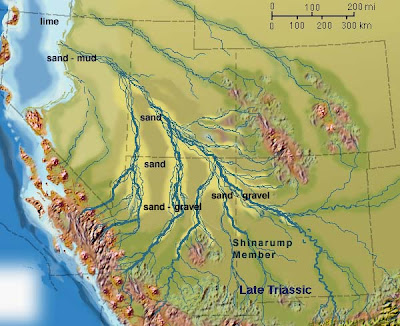
Continuing on our journey through time on the Colorado Plateau, we explore the Chinle Formation, one of the most diverse and distinctive layers in the region. It forms most of the scenery at Petrified Forest National Park, and is ubiquitous in such widespread locales as Capitol Reef and Canyonlands National Parks, Grand Staircase-Escalante National Monument, Zion National Park, and Glen Canyon National Recreation Area. The formation was laid down during the late Triassic, a time of huge changes in the world, especially in the biosphere. It was the age of the earliest dinosaurs, but the world was populated by a host of unusual reptiles and amphibians. The Chinle was an ideal environment for preserving fossils: the shales, siltstones, sandstones and conglomerates were laid down in river floodplains and channels. The headwaters of the rivers were mountains far to the southeast, but a chain of volcanoes to the southwest provided vast amounts of ash to the landscape.

When the Chinle is sandwiched between cliff-forming layers, it forms distinctive lavender and red slopes, but is often covered by debris from the cliffs above. In parts of the Navajo Reservation and the region around Holbrook (known popularly as the Painted Desert), the Chinle forms spectacular badlands topography. The bright colors result from the oxidation of various metal ions in the clay layers, especially iron.


Map courtesy of Ron Blakey of Northern Arizona University

The trees of the Petrified Forest are the most famous fossils of the Chinle. Most of the trees accumulated as logjams in the large rivers that flowed northwest through the region. Some of the logs are as much as 100 feet long. Once buried in mud and ash, silica dissolved from the surrounding rock filled cell spaces or replaced the wood material entirely. Once again, metal oxides provide the striking colors, primarily reds and yellows.

It is pretty amazing that any petrified wood remains in the park. In the early part of the century, trains would stop nearby so people could carry off samples. At least one mining venture sought to grind the wood up into abrasives. Every year park visitors carry off more, but I notice that the National Park Service doesn't discourage the rumor that bad luck befalls those who steal wood. Ironically, people pay huge fines for stealing something that can be picked up free and legally outside the park. Some of the local rock shops even give away free samples.

The Chinle Formation also contains a rich vertebrate fossil record. Phytosaurs and metoposaurs are commonly found, as well as Coelophysis, one of the earliest carnivorous dinosaurs. Hundreds of their remains have been discovered at Ghost Ranch in New Mexico. Plateosaurus and Chindesaurus are two relatively small ancestors of the giant sauropods that dominated the later Mesozoic. A rich assemblage of other fauna and flora have been discovered. A nice review of the paleontology of the Chinle can be found here.

The Chinle has another heritage, a far more insidious one...our next post will explore this in more detail.

Wednesday, August 13, 2008

Mid-week Mystery Sample: What is it? Heck if I actually know!


Well, that just beats all. We community college instructors often revel in the fact that we know a little bit about a lot of things instead of a lot about some specific things, but sometimes it helps to actually know a lot. Back when we found the mystery sample of the Chinle Formation, we wondered if it was a coral, and how a coral could have gotten into the Chinle, which is a terrestrial formation.
As I described in the previous post, I thought I had discovered the answer to the mystery when I saw a metoposaurus in the visitor center at Petrified Forest National Park (shown in the photo above), given the unique pits in the skull plates. The metoposaurs were large carniverous amphibians. I couldn't exactly make my sample line up with any particular part of the skull, but it was an adequate answer for me, the non-expert. In the best tradition of bad science, I didn't continue to explore other hypotheses once I had an answer that satisfied me. That's the kind of attitude that drives me nuts when my students are trying to identify rock and mineral specimens ("it's clear so it must be quartz, even if it cleaves").

Of course, running a blog demonstrates your ignorance to anyone who wants to pay attention, so I say thank you to an actual paleontologist, Jerry Harris, who suggested my sample could also be a phytosaur scute. So I am properly chastised for not covering my bases (y'all notice I could have said I knew it was a phytosaur all along....). I am at the same time happy to find that I might have a piece of phytosaur. They were one of the fierce predators of the Triassic: somewhat crocodile shaped, up to 30 feet long, and overall pretty cool.


Picture from Wikipedia

(This post has been revised)

Mid-week Mystery Sample: What is it?

So what is it? In the early 1990's, I was conducting one of our first field trips through the Colorado Plateau region, and at a stop to observe the sediments of the Chinle Formation, one of the students picked up the sample seen in the picture. I am admittedly not a paleontologist, but I looked and looked and couldn't make heads or tails of it. It sat on my desk for seven or eight years, until I walked through the visitor center at Petrified Forest National Park (the park is a showcase for the Chinle Formation), when I got it! Can you?

Tuesday, August 12, 2008

Time Beyond Imagining - A Brief History of the Colorado Plateau: Into the Triassic

The first period in the Mesozoic Era is the Triassic, which lasted from about 245 to around 200 million years ago. The world's continents had been combined into the supercontinent Pangea, and the biosphere had just been subjected to the worst extinction event ever recorded in earth history, with something like 95% of all species wiped out. It is as if the world were starting over, with a new cast of characters, and new landscapes. In the Colorado Plateau region, two formations were laid down: the Moenkopi Formation, and the Chinle Formation.

The Moenkopi was formed in river floodplains and shallow lakes, the shales and sandstones stained bright red by iron oxides. Distinctive ripplemarks, channel deposits, and mud cracks attest that the environment was in turns wet and dry, under either arid or subtropical conditions. The source of the sediments was from mountains far to the southeast, sloping towards a northwest shoreline near present-day Nevada and western Utah. Numerous trackways attest to the presence of numerous small reptiles and amphibians, but bones are rarely preserved. Great places to see the Moenkope? Try the western and southern part of Zion National Park, the basal cliffs of Capitol Reef National Park, at Cliff Dwellers near the Navajo Bridge downstream of Glen Canyon Dam, the region near Tuba City and Moenkopi, and along the Colorado River near Moab, Utah, which is the subject of today's photograph.

I am kind of cheating with today's picture. It shows the Fisher Towers along the Colorado River near Moab, Utah, along Highway 128. The La Sal Mountains form the backdrop. The Moenkopi Formation is in fact visible in the picture, but only as the darker tops of the towers, and the red slopes to the left. I consider this road to be one of the most spectacular drives in North America, especially in the evening light. I just happen to really love the picture and was looking for an excuse, any excuse, to use it!