Showing posts with label North Rim. Show all posts

Thursday, August 4, 2016

Notes from the Monsoon in Grand Canyon National Park


One of the most awesome things I've ever seen

Timing is everything. If one schedules a trip to the American Southwest in July or August, one may very well have to contend with the monsoons, the change in prevailing winds that brings warm humid air out of the Gulf of Mexico. The hot weather produces convection cells and intense thunderstorm activity, and flash flooding is a deadly possibility. Such flooding was in the news today in Utah and Arizona (here and here).
No, I didn't get a lucky shot, it's a screen capture from a video I took of the storm.
I got incredibly lucky in my travels this last week. We spent three nights on the North Rim of Grand Canyon (two of them in tents), and we got two evenings of dramatic clouds with all kinds of lightning and thunder in the distance. A bit of rain fell (with some serious thunder), but not enough to soak our gear. We had a delightful pair of evenings watching the light show from the viewing deck of the Bright Angel Lodge.
Storm cell over the South Rim of Grand Canyon
The third evening seemed calmer, and we saw only a few lightning bolts in the far distance. We headed into the lodge for dinner after the sun set and were enjoying our food, but we became aware that things were changing dramatically outside. The lightning strikes were happening only seconds apart, and the thunder was deafening. Rain was filling the canyon below. Like idiots we went outside in the raging storm to watch! I live in an area that gets maybe one or two thunderstorms a year, so I'm easily impressed. But there is another aspect: rainbows, sunsets, and lightning strikes are beautiful in their own right, but placed against the backdrop of one of America's greatest national parks they become truly awesome.
Sometimes you just need to look up

Though lightning was striking only a few hundred yards away, no one was hurt so far as I know. The rain fell for most of the night on Monday, and in the morning the ground was thoroughly soaked and everything felt fresh. The storms gained in intensity the following day, and there are now reports of flooding in places where I was eating lunch in the hot sun just a day ago.

One can never underestimate the power of flash flooding. It has proven deadly many times over through the years. No matter how strong you are, you simply cannot swim out of a rapidly swirling mix of mud, boulders, and water. If you are ever in the southwest exploring slot canyons, be aware of the weather. They became slot canyons precisely because of flash flooding. Even just driving your evening commute in Phoenix or Las Vegas can be dangerous. Take the warnings seriously.
The monsoons are dangerous, but they also bring needed rain to an area ravaged by drought for most of the last two decades. And they bring great beauty. I hope you enjoy this selection of photographs from my trip to the Grand Canyuon.

Tuesday, July 16, 2013

America's Never Never: North Rim or South Rim? It's a Grand Canyon everywhere, does it matter?


It means a lot to these guys anyway. The Kaibab Squirrel is a (sub)species of squirrel that lives only in the ponderosa forests of the North Rim of Grand Canyon. The most closely related species is the Abert Squirrel that lives on the South Rim of the canyon (and other parts of the Colorado Plateau), and never do the twain meet. The populations became separated at the end of the last ice age, and geographic isolation in different climates has led to differences between them.
We continued our exploration of America's Never Never, arriving at the North Rim of Grand Canyon National Park (after making our way through a herd of buffalo). I've been using the term "Never Never" after a region in Australia that is far off the beaten track, though full of fantastic geologic scenery. In a similar way, the Colorado Plateau is largely a barren wilderness, but it also encompasses some of the most beautiful landscapes on the planet. And some corners can hardly be described as isolated and lonely. Grand Canyon is one of those places: it gets as many as 5 million visitors a year.

It's a grand place, and one can choose to visit the developed parts of the park on the North Rim or the South Rim. One might wonder if it makes much difference which rim to visit if one is visiting for the first time. It's an interesting choice.
It really depends what you are after. If you are after the complete "industrial tourism" experience with IMAX theatres, four-star hotels, fancy visitor centers and complete visitor services including grocery stores, curio shops, restaurants, and full cellular service, then maybe the South Rim should be your destination. It is in fact the destination for something like 90% of the people who visit the canyon.

The North Rim is the flip side of the Grand Canyon experience. It usually takes several hours more to get there, and the nearest town of any sort is more than an hour away. There is a single hotel complex offering cabins, and a simple camp store. There is a one room visitor center, a laundromat/shower house, and not much else. What is the serious tourist to do?

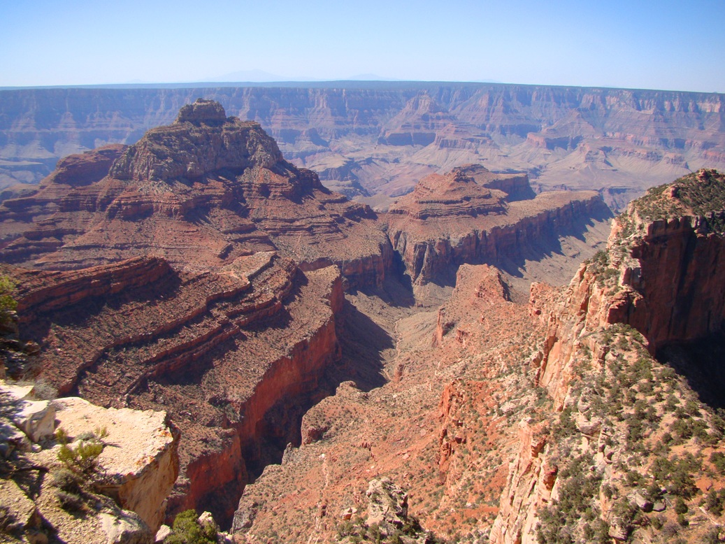
In my mind, there's not much of a contest. I enjoy my visits to the South Rim, but I prefer the quiet and the coolness of the North. It is as much as a thousand feet higher than the South Rim, and instead of a dry pinyon forest with occasional ponderosa groves, the North Rim has meadows with extensive forests of ponderosa, fir and aspen. The road to the viewpoints on the Walhalla Plateau is rarely crowded, and the viewpoints are stunning. Cape Royal and Angels Window offer excellent views of the Proterozoic Grand Canyon Supergroup and the famous angular unconformity that separates it from the overlying horizontal Paleozoic sediments (above).

Point Imperial offers a unique perspective on possible origins of the Grand Canyon. It looks over the edge of the Butte Fault and East Kaibab monocline into the lower country to the east. The Colorado River comes from this lowland and crosses the 8,000 foot high plateau heading west. The question that geologists have been struggling with for decades is how the river could have done it. There are many ideas, and few conclusions.

And then there are the quiet walks along the rim. The Widforss Trail goes five miles past the head of a deep gorge called the Transept, and to a beautiful view down into the Granite Gorge. The Uncle Jim Trail loops out to Uncle Jim Point at the head of Bright Angel Canyon. And if you aren't feeling particularly ambitious, follow the Transept Trail from Bright Angel Lodge to the Campground. That's what I did with my free time that day (oh, not to mention the pizza at the deli; it's not a completely savage wilderness).

Anyone on the North Rim should walk the short distance to Bright Angel Point. You'll have company, but the view is memorable. A fairly large number of people walk the Transept, but on the day I was there, I shared the trail with just four other people. It was quiet, cool and beautiful. I've never been closer to California Condors than here along the trail. They hang out, waiting for a tourist to drop I suppose.

In any other setting the 3,000 foot deep Transept would be a national park in its own right. Here it is but a tributary to Bright Angel Creek, which is a tributary to the Colorado River. The trail follows some gentle ups and downs through shallow swales and passes a modest Ancestral Puebloan ruin.
The campground is perched almost on the edge of the Transept, and the best-situated campsites offer views, but scenery is a short walk in any direction. It is a wonderful place.

This discussion of North Rim vs. South Rim leaves out a lot of other possibilities...there is the drive through the Hualapai lands to the bottom of Grand Canyon at Diamond Creek or that strange glass walkway perched on the rim of the western Canyon. There is the road that accesses Hualapai Hilltop and the isolated village of Supai. There is the road out to Toroweap and Vulcan's Throne. There is the wilderness of the Shivwits Plateau out west, a "twin" to the Kaibab Plateau with barely a road or trail anywhere. And there's that totally opposite way of seeing the canyon, from the bottom looking up rafting along the Colorado River, an adventure I am eagerly awaiting in less than two weeks.

Saturday, July 13, 2013

Out in America's Never Never: Is it the Journey or the Destination? Plus an unkindness and a bunch of bull...

Our exploration of America's Never Never included a lot of destinations: Zion, Bryce, Arches, Black Canyon, Mesa Verde and many others. But what is the value of seeing specific points in a landscape without seeing the lands between? Sometimes I have to convince my students that sleeping while traveling between incredible places causes us to miss the context of each of our stops (don't look for hypocrisy on my part; it's too easy. I sleep a lot on the road). If we only see specific sites, and miss the transitional landscapes that lie between them, we miss out. This is especially true while traveling between Zion National Park and Grand Canyon National Park. The two parks could hardly be more different: the rocks of the Grand Canyon are Proterozoic and Paleozoic in age. The walls of Zion Canyon are composed of Mesozoic rocks, primarily the Navajo Sandstone.

What happens in between? How do we transition between 100 million years of geologic history? As we drove beyond Kanab and Fredonia onto the sage-covered plains, we could look north and see the Grand Staircase. It is a series of cliffs that contain all of the sediments that once covered the Grand Canyon region, but which have been eroded away in a northward direction. Clarence Dutton coined the term in the 1870s and identified each cliff by color: Chocolate, Vermilion, White, Gray and Pink.
Source: National Park Service

The Grand Staircase is preserved today as the western part of Grand Staircase-Escalante National Monument. It is a larger park than Grand Canyon, and contains a diverse landscape of deep slot canyons, high plateaus, faults and monoclines. The origin of the park was clouded by controversy (President Clinton established the park over the objections of local politicians), but new national monuments often are controversial.
We soon left the arid plains and climbed to higher elevations on the Kaibab Plateau, the vast uplift through which the Grand Canyon has been carved. The scrub and pinyon forest fell away and a thick forest of ponderosa and fir dominated the scenery. Soon we were passing through green meadows, a sharp contrast to the dry lands below.

It is odd that literally no streams or rivers cross the surface of the plateau. It turns out that the Kaibab Plateau is covered by the Permian-aged Kaibab Formation, a layer composed mostly of limestone. Limestone is soluble in slightly acidic water and joints and fissures will grow into caverns. The ceilings of some caverns will collapse, forming sinkholes. Any surface water tends to disappear into the subsurface quickly. Such surfaces are said to exhibit karst topography.

Some of the sinkholes will fill with clay or mud, forming an impermeable layer. It is these sinkholes that will develop into the lakes and ponds occasionally found on the North Rim. They are pretty much the only source of open water and thus are important to the animals that live here.

 We usually arrive at the North Rim of the Grand Canyon in the late afternoon when the shadows are crossing the meadows and grazing animals start emerging. I've learned to see black spots in the distance and identify the creatures before anyone else. Often there are deer, and often a flock of ravens, which I learned tonight is called an "unkindness". I guess that's better than what they call a flock of crows...
On this trip I saw specks in the distance that looked different than anything I had ever seen before in twenty-five years of travels to the North Rim: too fat to be deer, and too large to even be cattle, which aren't supposed to be here anyway. It was a herd of buffalo!
Or "more or less" buffalo. It turned out this was a herd that originated in the adjacent House Rock Valley. They were the result of an experiment in the 1920s to "beef up" the cattle herds by crossing them with bison. It didn't work out, but the "mostly bison" continued to live in the valley over the years. Since they aren't a genetically pure herd, the state of Arizona sells permits to hunt the animals, and for a long time the herd remained relatively small.
Enter global warming and the crippling drought that has affected the region for the last 10 years. The herd moved uphill to find greener pastures, and fences and park boundaries mean little to these large animals. They found their way onto the meadows of the Kaibab Plateau and took up residence in grasslands that have not felt the hooves of creatures this big in thousands, maybe tens of thousands of years.

It was exciting to see these creatures, a feeling reminiscent of being in Yellowstone National Park, but it was disturbing as well. The animals trample springs and meadows, and may be upsetting the checks and balances of the local ecosystem. The park service is quite unsure about what to do.
Definitely a bunch of bull!
A few more miles, and we arrived at our destination: the North Rim of Grand Canyon National Park! And what a grand place it is. More later!

Friday, July 27, 2012

A Break from the Drought, Sort of...Flowers on the Colorado Plateau

What a dismal year it has been...not in geology, but in the "overburden" that often hides the outcrops. The drought that is affecting so much of the country meant that wildflowers were notable for their absence in almost all my travels this spring and summer, whether in the Central Valley, the Sierra Nevada foothills, or the Colorado Plateau. It is kind of upsetting to realize that I spent two weeks in six states and took a grand total of two pictures of flowers...and both were in front of visitor centers where they had been watered. It really was that bad.

Last week we were in Arizona and Utah for a short sojourn, and we purposely headed for the handful of places where we thought wildflowers might have a chance of flourishing, even in dry times: the North Rim of the Grand Canyon (close to 9,000 feet), and Cedar Breaks National Monument (just over 10,000 feet). We were happy to see that at least in these islands of cooler weather that some flowers were blooming.
I also had a chance at long last to meet the Geogypsy, my blogging friend Gaelyn, a ranger on the North Rim. She sadly pointed out that the flower displays, while colorful, were not up to normal levels. Just the same, we enjoyed the rainbow hues of these little gifts of nature.
On the North Rim of Grand Canyon, there is a road that goes out onto the Walhalla Plateau, a mesa that extends far out into the gorge. There is a "Y" junction with roads to Point Imperial and Cape Royale. Driving through the junction, we saw a splash of color and just had to stop. We counted at least a dozen species of flowers in a few minutes.
Of course, being who I am (lazy), I barely knew the identities of the majority. I guess that means there is about to be a bit of competition to see who can name the flowers accurately and quickly (come on, I identify rocks for just about anyone who asks!).
I had not been to Cedar Breaks National Monument in many years, and the rocks were spectacular as ever. I was a bit shocked by the beetle-killed trees, though. The bugs had an earlier start at Cedar Breaks; the infestation started killing the trees in the 1990s. It was not as terrible looking as the beetle devastation in central Colorado (and apparently Wyoming and British Columbia too) where millions of acres have been wiped out. The young firs are starting to come back after a decade and a half.
But denuded trees means more sunlight on the ground, so even with drier conditions, the flowers were quite beautiful.
 I hope the drought ends...
...but I would feel better if the politicians would at least acknowledge that there is a serious problem with our climate, and that the parties could come together to lead us to solutions to the problems we have caused with our atmosphere and hydrosphere.
In the meantime, enjoy a splash of color!

Wednesday, May 28, 2008

Grand Canyon's North Rim - The Transept

How many places are there in the world where a 3,000 foot deep canyon with walls so steep that one cannot see the bottom from the rim is an afterthought? The Transept is one of those special places on the North Rim of the Grand Canyon. It lies west of the Bright Angel Lodge on the rim, and is a large tributary to Bright Angel Canyon. You can look down into the canyon from the Transept Trail, a short stroll between the campground and the resort, or you can get a particularly spectacular view by walking about two miles out the Widforss Trail. The Widforss circles the rim of the canyon, providing the view down the gorge seen in the picture above.

The prominent cliffs in the lower part of the canyon are the Mississippian aged Redwall Limestone. The cliffs are about 500 feet high. The overlying redbeds are the Pennsylvanian-Permian beds of the Supai Group and the Hermit Shale. They are delta and floodplain deposits eroded from the Ancestral Rocky Mountains which existed at the time to the northwest in Colorado.

I had the privilege of seeing one of the last free-flying California Condors back in the 1980's in the hills north of Santa Barbara. When the population dropped to about 28 individuals, they were all captured and they started raising captive birds. As more and more of them matured, and the total number slowly rose, they began releasing the birds in the wild in a number of widely isolated locations in California, and in their old range of Arizona. A small population inhabits the North Rim at times. At the time of my last visit, I wasn't aware of the presence of these grand birds. But I did see some monstrously huge turkey buzzards flying around and finally realized that NOBODY was identifying turkey buzzards with number tags. These were condors, in range of my camera! It was a neat moment, although I kept trying to get a picture without the number tag, but getting a picture of a Condor with the Grand Canyon as a backdrop was thrilling enough.

Sunday, May 25, 2008

Why I Love the North Rim

Seeing my students graduate is really great, but taking a person to a place like the Grand Canyon for the very first time is an even greater thrill for me as a teacher. We stay most years on the North Rim most years for a number of reasons.

The South Rim gets something like 90% of the visitation, which is reason enough to avoid it, but because more people are there, the rim has more trailheads, more facilities, museums and so on. The North Rim, in contrast, is around 1,000 feet higher, cooler, and more moist, and thus the forest is predominantly composed Ponderosa Pine (instead of pinon), and there are more meadows. One of the nicest aspects is the location of the group campground: it is only a few hundred feet from the rim (South Rim campgrounds are nearly a mile back). I prefer the views from the North Rim; the higher elevation offers a panorama of the landscape south of the rim, including the San Francisco Peaks volcanic field.

Today's picture is a morning shot looking south towards the San Francisco Peaks. I will have to leave it to others who know more about this kind of thing to explain why there is a gigantic composite volcano and associated volcanic field here. I imagine there is a sort of 'manhole' effect where lavas are leaking out from under the thick continental crust of the plateau country where it has been faulted by the current extensional regime, like a sewer system backing up. The high point on the rim, Humphrey's Peak is over 12,000 feet high (Arizona's highest mountain), but the original summit may have been several thousand feet higher. From the east, the complex looks surprisingly like Mt. St. Helens. The field is mostly Pleistocene, and at least one volcano erupted within the last 900 years (Sunset Peak National Monument).