Showing posts with label Calaveras Complex. Show all posts

Wednesday, November 18, 2015

The Karst Topography...of California? There are more than 1,000 wild caves in California. Here's one of them

There is something special about exploring a wild cave, the kind without admission fees, guides, trails, and railings. There are a thousand limestone caves in California (and hundreds of lava tubes), and not even a dozen of them are show caves, i.e. open for business.There are usually reasons the wild caves do not become "tour caves". They may be too short, too inaccessible, maybe even too dangerous.
The wild caves have suffered varying levels of abuse and vandalism. Few of them are protected by any kind of legal authority and are rarely patrolled. They are mostly protected by secrecy, and small groups of serious spelunkers. I've been privileged with the opportunity to explore a couple of them, and as part of my miniseries on the karst terrain of California, I'd like to share one with you.
A nearly empty New Melones Reservoir and the gray marble of the Calaveras Complex.
Karst topography, as described in the previous posts, is a landscape underlain by cavern-filled marble or limestone. Cavern roofs can collapse, forming sinkholes, blind valleys and disappearing streams. The marble, a part of a metamorphic terrane called the Calaveras Complex (late Paleozoic-early Mesozoic), can be seen as gray slopes in the photo above. Many incredible caves were drowned by the waters of the reservoir in the foreground of the picture. Others open out into sheer cliffs above. Few are easily accessible. We had to walk a steep mile to get to the caves we're exploring in the post today.
Oak woodland in the vicinity of the caves
That's what makes these caves special. They are at the end of a pretty stiff hike, but they have accessibility, and are relatively undamaged (this concept is relative; some would call them heavily damaged, but many parts are in good shape). They're not crowded. Months may pass between visits.


When we have a group of newbies who have not explored wild caves before, we do some training on safety, both for the explorers, and for the caves themselves. We stress the importance of exploring in least intrusive way possible, not touching the rocks, and not disturbing any life if possible. We crawl through a short cave with a few narrow passages in preparation for entering the much larger cave to follow.
We finish our spelunking practice at the small cave, and move on towards the larger, more challenging cave. Accessing the cave requires first descending between huge fallen boulders. The cave had grown so large that portions of the roof had collapsed to form a sinkhole. We find a spot with good footholds and climb into the darkness.
The second challenge is getting into the main cave via a narrow passageway at the base of the rockfall. One has to push upwards and twist through the tight little space. Some of the explorers describe it as being "born again".
The entrance merges into a more open room that serves as the "subway" into the largest room in the cave. This passage is where most of the speleothem damage has occurred. It's not exactly the work of vandals, as the breaking of the formations was probably for the purpose of making an easier passageway into the room beyond. This kind of thing happened to many caves discovered in olden days. I don't know anything of the discovery and original exploration of this particular cave.
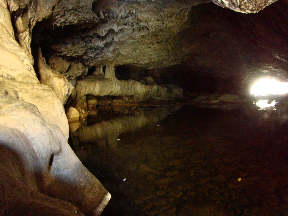
This passage leads into the main room of the cave, which more than 100 feet long, and 20-30 feet high in places. We come face to face with a spectacular wall of mostly unbroken stalactites (they were protected by being out of reach).
The room is richly decorated with all kinds of dripstone and flowstone features. Some are brown from torches of the early explorers, or from mud seeping through the cracks above. Other features show evidence of recovery from the "dirty early years". The adoption of clean caving techniques in the last few decades shows as some of the cave features are covered with a thin layer of pure white calcite. Some of the caves are being cleaned by volunteers as well. In some cases, people haul gallons of water down difficult trails, set up hoses into the caves, and then spray mud off of damaged speleothems.
There are all kinds of nooks and crannies to explore. There is a false floor in the cave that offers a loop crawl. There is a small passageway called the bedroom and another called the jail room. Openings high on the walls and ceiling hint at other passageways. In a side room, one can view a sinkhole from the underside, looking up at a mass of boulders that had collapsed down into the cave, but have since been cemented together by flowstone to form the ceiling of the room.
What about cave life? We've seen spiders near the entrance, and unusual looking snails. In previous trips we have seen six inch long centipedes, and Ensatina salamanders. There have been a couple of bats. The total darkness of caverns offers little in the way of food, so the biomass quantity of the cave is very low. The creatures that do exist are highly adapted to environment of the caves.


The wilderness caverns of the Sierra Nevada are a precious and irreplaceable resource. The breaking of any speleothem destroys the result of thousands, even tens of thousands of years of slow development. They can never be replaced in any kind of human lifetime.
It is a rare privilege to be able to explore this underground wilderness, and it is a privilege for me to introduce my students to this strange new world.
A cave is such a strange and alien world for a human being, at least the deeper parts away from the light. No wonder that some of our first art was scrawled on cavern walls as sort of drug-free hallucination of alternate worlds. Caves were portals to lower worlds, or were the avenues for emergence into our current world. Sitting in the darkness, I can feel a connection to my ancestors.

You have no doubt noted that I have not provided the names of the caves we explored. If you want to get involved in cave exploration, you should contact your local grotto of the National Speleological Society. They provide instruction and training, as well as chances to clean and rehabilitate caves that have been damaged by vandals and overuse. They are great people. And don't forget, the tourist caves in the Mother Lode are wonderful. They are safe and easy to explore. Check them out!

This post is a highly altered version of a post based on our trip in 2014. If you want to see how badly I plagiarized myself, check out the original post here:  http://geotripper.blogspot.com/2014/11/to-explore-wild-cave-underground.html

Thursday, November 12, 2015

The Karst Topography...of California? Into the Black Chasm

California is not really known for her expanses of karst topography, the landscapes that develop where limestone or marble lies underground. In my short mini-series about the karst of California, we've seen the gold-fields of Columbia State Historical Park, the grinding stones at Chaw'se State Park, and the Natural Bridges of Coyote Creek. Today we are going underground to see the reason for the sinkholes and disappearing streams: the caverns of California. Believe it or not, there are more than a thousand of them! There are about eight of them that have been developed for tours. We'll have a look at some them over the next few posts.
On our recent trip exploring the karst topography of the Sierra Nevada Mother Lode, we visited one of the most unique: Black Chasm Cavern, near the Gold Rush town of Volcano. Black Chasm was opened for tours around 1990, but it has been known since the Gold Rush days.
An early discovery by miners is usually the death-knell for a cave. The early explorers tended to be careless, and they thought nothing of breaking off cave decorations (speleothems). Such caves eventually became muddy holes in the ground, bereft of any beauty. But Black Chasm had something going for it, something that protected the cave: it was the Black Chasm itself.
Just inside the very step entry passage, there is a 100 foot deep fracture that halted any further exploration of the cave unless the spelunkers had technical climbing gear. Far down at the bottom of the chasm, there is a turquoise colored lake. When the cave was developed, the owners affixed a stairwell across the upper part of the chasm, providing access to the Landmark Room at the far end of the cave (the tour covers several hundred feet of the cave, which has a total of about 4,000 feet of passageways).
The Landmark Room is a true revelation for cave enthusiasts: it's almost completely untouched by vandals and sloppy cavers. The speleothems (cave decorations like stalactites, stalagmites, columns, draperies, and flowstone) have never been snapped off or otherwise damaged.
The stalactites and draperies are spectacular. The owners have done a good job of lighting the cave to highlight the most interesting decorations. I've toured the cave a dozen times or more, and I always find something else to photograph.
It's quite amazing to see draperies that have never been stained by the grime of torches and candle lanterns.
The speleothems could be easily snapped off, but it has not happened. It's a marvelous privilege to see untouched caves. But Black Chasm has achieved National Natural Landmark status for a different reason: the helictites. National natural landmarks are established by the federal government, but the land where these landmarks have been established are privately owned. The status represents an agreement to protect the landmark from damage or development. 
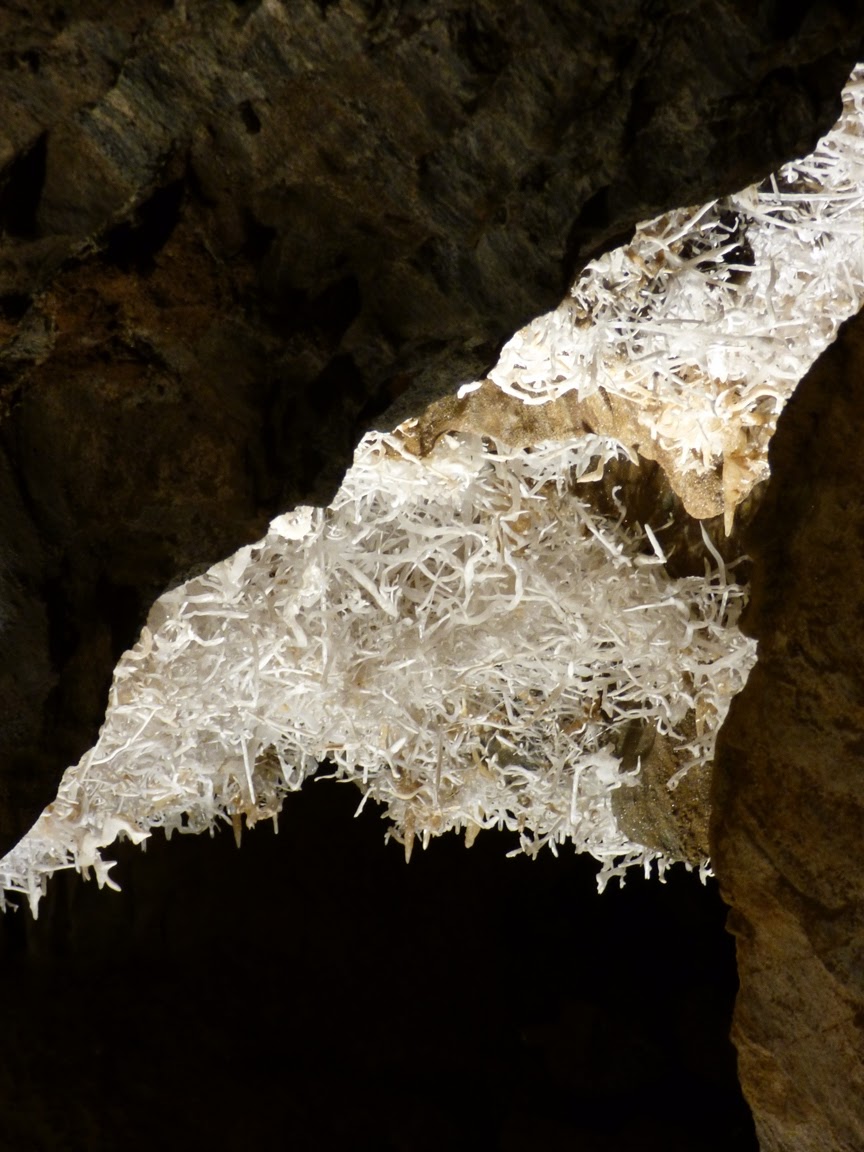
The helictites at Black Chasm are extraordinary. They can be thought of as stalactites on an acid trip, as they seemingly have completely disregarded gravity as they have grown. They may start growing in the style of stalactites, but water can be squeezed from the interior under hydrostatic pressure, and grow in random directions. They aren't immediately apparent on the conducted tour, because they actually keep the lights in that corner of the cave off (we look where we are directed, after all). One begins to notice the helictites here and there in dark corners, a few dozen on the cavern walls. I'm perhaps giving something away here, but I am surprised every time the lights come on.
Because that's what happens. The lights come up, and there is a wall covered by thousands upon thousands of helictites in a chaotic pattern that is simply stunning.
Helictites are among the most delicate of cave decorations, the first to be destroyed by vandals and careless cavers. But this cave was protected for a century by the Black Chasm, and the owners have been careful to preserve this incredible resource. They were never broken off, and as such, this wall of crazy stalactites is probably the most complex and spectacular group of helictites that can be seen in any show cave in the country, maybe in the world.
The cave is operated by the Sierra Nevada Recreation Corporation, and the cave is generally open all year for tours. They offer discounts for educational tours like the one we took two weeks ago. If you get a chance to tour the Mother Lode, Black Chasm is certainly worth a look. For more information, check out their website at http://caverntours.com/black-chasm-cavern-national-natural-landmark
The

Monday, November 9, 2015

The Karst Topography...of California? California has Natural Bridges, and not Just in Santa Cruz

I've been reviewing some of the stops on our recent field studies course through the karst country of California. This landscape is the portion of the Sierra Nevada Mother Lode that is underlain by the marble of the Calaveras Complex. The marble originally formed as limestone on the floor of the Pacific Ocean, and was mashed into the western edge of North America as the ocean floor was thrust beneath the continent along a subduction zone several hundred million years ago.

The marble was eventually uplifted and exposed at the earth's surface by erosion. The term "karst" refers to the tendency of such landscapes to develop sinkholes as underground caves collapse. Rivers have a tendency to disappear in such places. In today's post, we look at a creek that disappears, and reappears. Twice.
There is a place called "Natural Bridges" that is familiar to many Californians. It along the coast at Santa Cruz, and is actually a sea arch eroded by wave action. Less familiar are the Natural Bridges that span Coyote Creek between Columbia State Historical Park and Vallecitos on Parrot's Ferry Road in the Mother Lode.
In geologic terms, a natural bridge is usually taken to be an arch that has formed as a result of stream erosion. The epitome of such arches are found in Utah at Natural Bridges National Monument in the state of Utah. The bridge at Santa Cruz is more properly termed a "sea arch". Karst processes can also produce bridges, as an erosional remnant left behind as caves collapse, leaving openings through which water is flowing.
The Natural Bridges of the Mother Lode are certainly karst related, but in a slightly different manner. At Coyote Creek, springs of carbonate-laden water emerged from the hillside above the river, and calcium carbonate, the mineral that makes up limestone and marble, was precipitated into large masses called flowstone (a great deal like Mammoth Springs at Yellowstone National Park). They blocked the creek, but eventually water worked through the base of the spring deposits. Eventually the creek carved a course under limestone dam. The cavern has since been decorated with all manner of speleothems, stalactites, stalagmites, columns, curtains, and others. As can be seen in the pictures above and below, the springs are still active. There is a constant music of dripping water at the entrance to the upper bridge.
You can get a sense of the falling water in the shaky low resolution video below.

There are two bridges on Coyote Creek. Most hikers visit the upper cave, which is at the end of a relatively gentle one mile trail. It takes a bit of scrambling to get to the upper entrance to the cave, but it's apparently a fun float or swim through the several hundred foot long cave. I haven't had the privilege, as I've visted most often during the late fall season when the water has been cold.
It is possible to walk well into the entrances without getting too wet.
The bridges have suffered quite a bit of damage over the years. Tourists have been visiting the site for more than century. A hotel even was constructed on top of the upper bridge for a time. Many of the cave decorations have been broken off. Luckily, floods flush out the cave every so often, and it is high enough that some decorations are out of reach of vandals.
The lower cave lies several hundred yards downstream. Far fewer people know about it, and it is a bit of a challenge to get there. One can follow the creek for the most part, but the way is blocked by brush here and there, so trails of use climb the canyon walls in a few illogical-seeming spots. It's worth the effort, if just to get away from the occasional crowds at the upstream caves.
It's a bit shorter and the downstream exit is visible from the upper entrance (which makes some a challenge of some picture angles).
The bridges are on public lands administered by the Bureau of Reclamation (New Melones Reservoir lies just downstream), so the caves are nominally protected by ranger patrols, though I've never seen one. Mostly those of us who enjoy the caves need to be vigilant for vandals. Check this link for directions and maps to the caves: http://www.usbr.gov/mp/ccao/newmelones/planning_visit.html.
One of the nice things about the walk to the lower cave is the smooth exposures of marble along the creek between the two. It is white marble streaked with gray, and has been polished by numerous floods. The Calaveras marble originated as coral reefs or carbonate muds in tropical environments in the tropical latitudes of the Pacific Ocean. Strangely enough, the marble was featured on the front page of our local newspaper this week. It's about a marble quarry just a few miles away from the bridges. Check it out: http://www.modbee.com/news/article43637292.html.

These rocks have been on an incredible journey.

Saturday, November 7, 2015

The Karst Topography...of California? Getting Filthy Rich from Karst in Columbia

The Fricot Nugget at the State Mineral Museum in Mariposa, California
As I noted in the last post, California has some unique landscapes that are unfamiliar to most visitors, specifically karst topography. Karst results when a region is underlain by limestone or marble. The formation of caves is sometimes revealed at the surface when the roof of a cavern collapses, forming sinkholes and related features. At Chaw'se in the last post, we saw how karst topography was utilized by the Miwok people. Today we look at how another culture used karst, and in the process nearly brought about the end of the Miwok and other native peoples in California. It was all about gold.
The southern Mother Lode in the vicinity of Columbia and Sonora.

The western part of the Sierra Nevada is composed not of granite, but of metamorphic rock like slate, marble and metavolcanic greenstone. The metamorphic rocks contained widely disseminated bits of gold, but hydrothermal activity related to the intrusion of granite in Mesozoic time concentrated the gold into veins of quartz and other minerals. The veins came to be known as the Mother Lode, and they were the source of riches and misery. In most cases the miners were after gold-bearing river gravels along rivers that flowed through the Mother Lode, or they developed mines that cut directly into the quartz veins. When the easy gold was gone from the rivers, they expanded their search into unexpected areas. One of those places was the ancient riverbeds of another era, long before the present day Sierra Nevada existed.
Fifty million years ago, the Sierra Nevada didn't not exist as a mountain range. There were the eroded remnants of an ancestral Sierra Nevada that developed during the late Paleozoic and early Mesozoic eras when masses of land slowly mashed into the western edge of North America, and when subduction zones produced magma that eventually became the granite of the high Sierra. Those mountains were gone, and instead there were slow-flowing rivers that had their origin in what is today central Nevada, with hints of headwaters much farther away, perhaps even Canada. The rivers flowed into a coastal complex that was characterized by swamps, jungles, and sandy beaches. These ancient rivers were ultimately diverted here and there by lava flows, which forced the water into new channels that became today's rivers, like the Stanislaus and Tuolumne. The ancient river gravels that remained were perched on high flat ground between today's river canyons. The gravels often contained gold, but something very odd happened at the site of Columbia State Historical Park. It involved karst topography.
The rocks near Columbia form a landscape unlike those found anywhere else in the Mother Lode, or anywhere in California for that matter. The limestone that formed in Paleozoic oceans 300 million years ago was recrystallized by heat and pressure into marble. Groundwater moved through cracks and fissures in the marble, widening the fissures, and in some cases forming caverns. A channel of the ancient rivers flowed over the roughened surface, and the fissures captured stunning amounts of gold. Eventually the rocks lay covered by two or three meters of soil and gravel. Until the miners found the gold...
The gold deposits at Columbia were unbelievably rich. According to some estimates by geologists of the California Geological Survey, some 4 million ounces of gold, worth about four billion dollars at today's prices was mined here. The entire production of gold in California over the last 150 years amounted to about 110 million ounces, so this one mining area produced a significant percentage of all the gold mined in California.
This gives us an explanation for the strange landscape around Columbia. The miners had very little water from local sources, so flumes and penstocks were constructed to bring water from higher parts of the Sierra Nevada. Instead of using sluice boxes or pans, the miners shot water cannons at the soils, moving vast amounts of sediment and quickly exposing the gold (this was called hydraulic mining). Parts of the town were built on gold-bearing soils, and there was the occasional suspicious fire that destroyed buildings, allowing the miners to blast away a bit more ground. What they left behind was a kid's wonderland of boulders, fissures, and small caves that is every bit as fun as Tom Sawyer Island at Disneyland (I'm disappointed that I didn't grow up as a kid around here. I had to settle for Tom Sawyer Island at Disneyland...).

It's probably no surprise to realize that the Gold Rush was a disaster for the native cultures in California. The indigenous people already been decimated by European diseases and unfortunately some of them lived in gold country. They never had a chance against the influx of tens of thousands of miners from all over the world. Some tribes disappeared entirely, and others barely hung on to their lives and culture.
Columbia hung on as a town after the gold deposits gave out, although the downtown area fell into disuse. In the 1930s, efforts began to make the area a state park, and in 1945 the town center was established as Columbia State Historical Park. The stores and restaurants were refurbished and visitors are treated to park employees and business owners in period dress. And a dandy candy store that is often the only business still open when our students arrive in town at the end of our field trip.

Friday, November 6, 2015

The Karst Topography...of California? An Exploration of Chaw'se

California can mean a lot of things to people: sunny beaches, snowy ski slopes, glacial canyons like Yosemite, or Redwood forests. But few people ever connect karst landscapes with our fair state. Karst topography? That's a unique terrain that develops when the underlying rock is composed of limestone or marble. It's the kind of landscape one expects to find in Florida, or Kentucky, or Ohio. But not so much in California.

Karst landscapes are influenced mostly the solution of the rock by acidic water, forming underground caverns. Often the caverns are hidden (kind of by definition if you think about it), but sometimes the roof of the cavern will collapse, forming sinkholes. Further erosion of the landscape can produce natural bridges and blind valleys (where rivers and streams disappear underground). Most of California has been too chopped up by faulting to have extensive areas of exposed limestone; it's just not all that common around the state, but it is present in a few places. Death Valley and the Mojave Desert have large exposures of limestone, but the dry climate precludes the formation of many karst features.

On the other hand, marble is found in the western part of the Sierra Nevada, where ancient marine sediments were compressed against the edge of the continent 200 to 300 million years ago. These rocks extend from the Gold Rush town of Columbia in the Mother Lode north past Jackson and Sutter Creek. There are also outliers in Sequoia and Kings Canyon National Parks. And in these rocks, there are caves. Lots and lots of caves! More than 1,000 have been discovered over the years. A few have been developed for tours. Kids in our region often have their first underground experience at Moaning Caverns outside of Columbia, and others have toured Mercer, California, or Black Chasm caves. Crystal Cave has been an important visitor destination at Sequoia National Park for many decades, along with Boyden Cave on the Kings River.
As strange as the rocks look in today's pictures, they are not actually karst features. They're human artifacts, grinding holes used by the Miwok people to crush acorns, one of their most important food sources. Most of the grinding pits in the Sierra are cut into granitic rock, but marble is a bit softer. An unusually large number of them are found in the huge slabs of marble exposed at Chaw'se State Park near the town of Volcano and Pine Grove (the park is sometimes called "Indian Grinding Stone State Park"; I prefer "Chaw'se, which means the same thing).
The holes preserve another unique feature found almost nowhere else: petroglyphs. Petroglyphs are a form of art or communication carved into rock surfaces.There were hundreds of them decorating the grinding holes. They've faded over the years, but some can still be seen. That they are disappearing is a sad consequence of the softness of the rock, and the susceptibility of the rocks to solution by acidic water.
It's not surprising that Chaw'se should be an important cultural center for the Miwok people and other indigenous peoples in the region. There are bark houses and a large roundhouse at the site, and they are occasionally used for ceremonies and celebrations.
The acorns have fed more than just people. A number of animals depend on the oak seed as well, including the comical looking Acorn Woodpeckers, one of which can be seen above.

These pictures are from our field trip last week for our class on the karst topography of the Sierra Nevada. The other highlight of our trip was an exploration of one of the most spectacular caves in the American west. That visit is coming up in a future post.

For more information about the park, check out http://www.chawseassociation.org/index.html and http://www.parks.ca.gov/?page_id=553