Showing posts with label New Melones Reservoir. Show all posts

Monday, November 9, 2015

The Karst Topography...of California? California has Natural Bridges, and not Just in Santa Cruz

I've been reviewing some of the stops on our recent field studies course through the karst country of California. This landscape is the portion of the Sierra Nevada Mother Lode that is underlain by the marble of the Calaveras Complex. The marble originally formed as limestone on the floor of the Pacific Ocean, and was mashed into the western edge of North America as the ocean floor was thrust beneath the continent along a subduction zone several hundred million years ago.

The marble was eventually uplifted and exposed at the earth's surface by erosion. The term "karst" refers to the tendency of such landscapes to develop sinkholes as underground caves collapse. Rivers have a tendency to disappear in such places. In today's post, we look at a creek that disappears, and reappears. Twice.
There is a place called "Natural Bridges" that is familiar to many Californians. It along the coast at Santa Cruz, and is actually a sea arch eroded by wave action. Less familiar are the Natural Bridges that span Coyote Creek between Columbia State Historical Park and Vallecitos on Parrot's Ferry Road in the Mother Lode.
In geologic terms, a natural bridge is usually taken to be an arch that has formed as a result of stream erosion. The epitome of such arches are found in Utah at Natural Bridges National Monument in the state of Utah. The bridge at Santa Cruz is more properly termed a "sea arch". Karst processes can also produce bridges, as an erosional remnant left behind as caves collapse, leaving openings through which water is flowing.
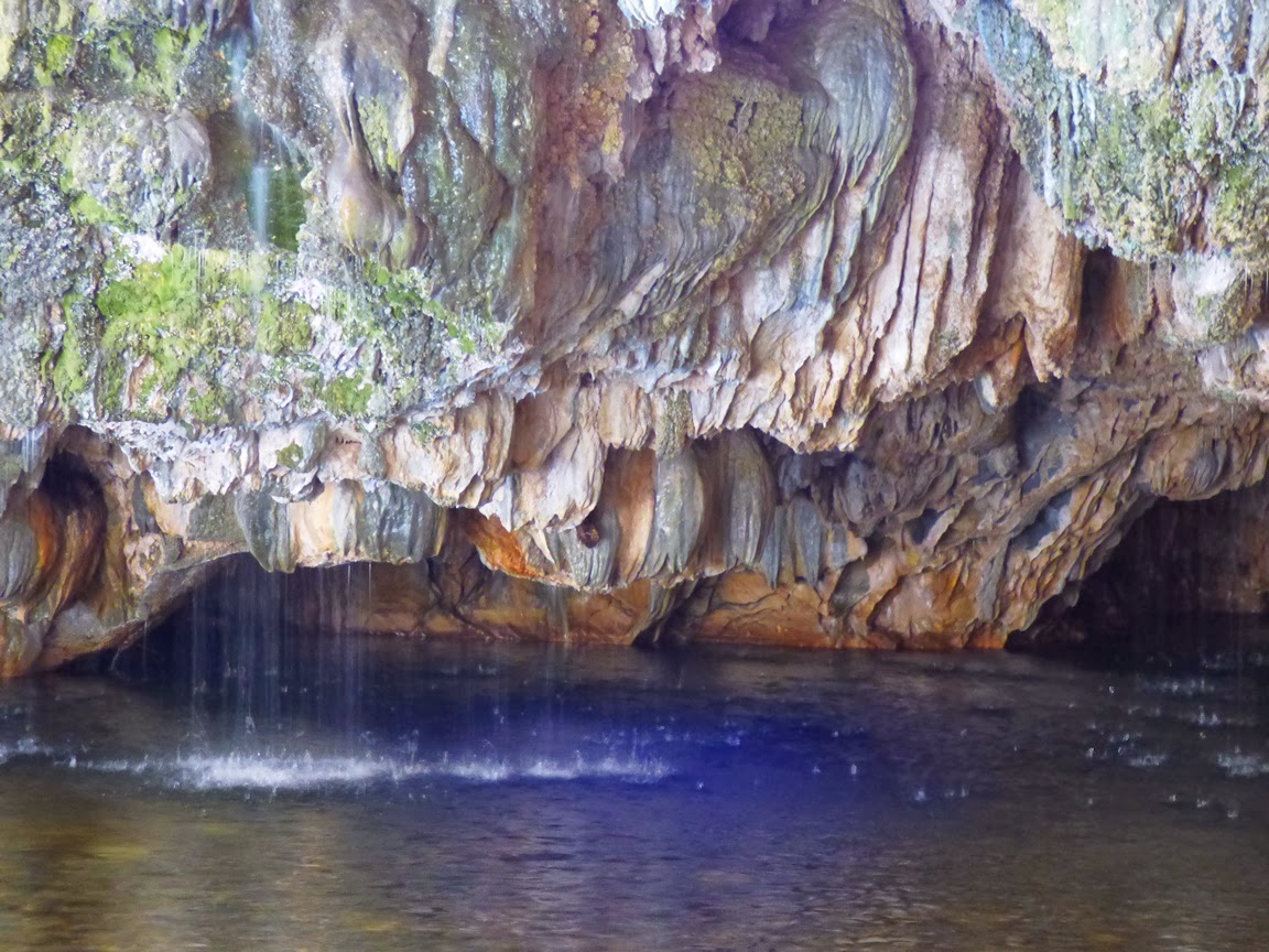
The Natural Bridges of the Mother Lode are certainly karst related, but in a slightly different manner. At Coyote Creek, springs of carbonate-laden water emerged from the hillside above the river, and calcium carbonate, the mineral that makes up limestone and marble, was precipitated into large masses called flowstone (a great deal like Mammoth Springs at Yellowstone National Park). They blocked the creek, but eventually water worked through the base of the spring deposits. Eventually the creek carved a course under limestone dam. The cavern has since been decorated with all manner of speleothems, stalactites, stalagmites, columns, curtains, and others. As can be seen in the pictures above and below, the springs are still active. There is a constant music of dripping water at the entrance to the upper bridge.
You can get a sense of the falling water in the shaky low resolution video below.

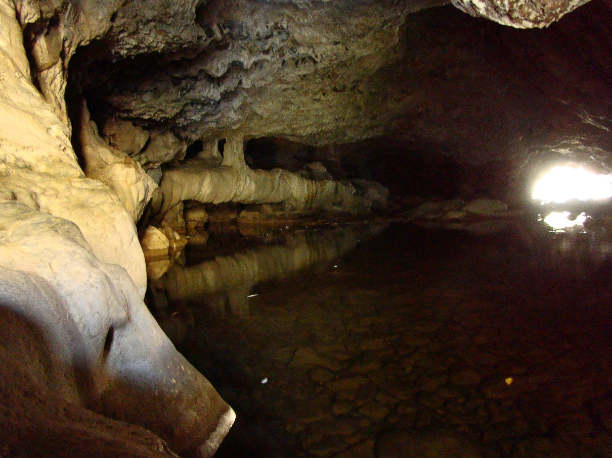
There are two bridges on Coyote Creek. Most hikers visit the upper cave, which is at the end of a relatively gentle one mile trail. It takes a bit of scrambling to get to the upper entrance to the cave, but it's apparently a fun float or swim through the several hundred foot long cave. I haven't had the privilege, as I've visted most often during the late fall season when the water has been cold.
It is possible to walk well into the entrances without getting too wet.
The bridges have suffered quite a bit of damage over the years. Tourists have been visiting the site for more than century. A hotel even was constructed on top of the upper bridge for a time. Many of the cave decorations have been broken off. Luckily, floods flush out the cave every so often, and it is high enough that some decorations are out of reach of vandals.
The lower cave lies several hundred yards downstream. Far fewer people know about it, and it is a bit of a challenge to get there. One can follow the creek for the most part, but the way is blocked by brush here and there, so trails of use climb the canyon walls in a few illogical-seeming spots. It's worth the effort, if just to get away from the occasional crowds at the upstream caves.
It's a bit shorter and the downstream exit is visible from the upper entrance (which makes some a challenge of some picture angles).
The bridges are on public lands administered by the Bureau of Reclamation (New Melones Reservoir lies just downstream), so the caves are nominally protected by ranger patrols, though I've never seen one. Mostly those of us who enjoy the caves need to be vigilant for vandals. Check this link for directions and maps to the caves: http://www.usbr.gov/mp/ccao/newmelones/planning_visit.html.
One of the nice things about the walk to the lower cave is the smooth exposures of marble along the creek between the two. It is white marble streaked with gray, and has been polished by numerous floods. The Calaveras marble originated as coral reefs or carbonate muds in tropical environments in the tropical latitudes of the Pacific Ocean. Strangely enough, the marble was featured on the front page of our local newspaper this week. It's about a marble quarry just a few miles away from the bridges. Check it out: http://www.modbee.com/news/article43637292.html.

These rocks have been on an incredible journey.

Sunday, April 19, 2015

Where the Rivers are "Upside-Down": A Hike to the Stanislaus Table Mountain

Around 10 million years ago, a lava flow surged from a volcano near present-day Sonora Pass in the Sierra Nevada. Composed of latite, but non-viscous like basalt, it flowed off the volcano and into the channel of the ancestral Stanislaus River, eventually flowing close to sixty miles. The river eventually eroded another valley and the lava flow was left relatively intact. The Sierra Nevada rose and tilted westward, and erosion removed the surrounding softer rock, leaving the former river valley as a ridge several hundred feet high. This was the origin of the Stanislaus Table Mountain, an inverted stream.
In this GoogleEarth image, the trail mostly follows the white line along the base, and then climbs the forested slope on the right.
Table Mountain forms a mesa-like ridge around Sonora and Jamestown in the Mother Lode of the Sierra Nevada. A lot of it is on private property, and as such is inaccessible for close investigation. But one portion lies within the boundary of the U.S. Bureau of Reclamation lands around New Melones Reservoir. The Bureau has constructed a trail to the summit, and that's where we were headed today on our Geology Club hike.
The trail is about 1.5 miles in length, and the first mile is a gentle grade through meadows and oak woodland. The grass was still green and wildflowers were reasonably abundant, but it isn't going to last. The soil felt bone dry, crunching under our feet. It's going to be a long, hot summer.
For the last half mile, the trail becomes increasingly steep. It's a climb of several hundred feet to the top of the lava flow. It was hot today, nearly ninety degrees, and I was appreciative that our trail was on the shaded north side of the lave flow. Oak trees provided shade, but also obscured the view but for a few choice moments.
The view provided us with confirmation of our progress up the mountain. But near the top the trail became a near scramble up the rocks. The short-cuts of use were hard to distinguish from the actual trail, as both were so steep.
The scramble was short, however, and we broke out into the barren surface of the top of the inverted stream. It was an alien landscape. Alien in the sense that it was covered mostly with actual native vegetation, unlike the grasslands below, which have been taken over almost entirely by European or Asian invasive grasses. The invasive species cannot compete in this harsh, mostly dry habitat. It was most certainly dry on this day, as we have had few rainstorms since February.
These rocky flats sometimes contain vernal pools and swales, and constitute one of California's rarest habitats. This section of the flow is one of the only protected portions of this type of landscape. The pools exist for only a few weeks at a time in the winter and spring seasons. At least one of the flower species here is found nowhere else in the world. In spite of the intense dryness, a few flowers persisted here and there, including on the shaded north slopes.

The top of the flow was a fine lookout for views in all directions.

The cliffs drop off steeply on both sides. The local casino lies directly below, and the abandoned open pit Harvard Mine lies just to the east.
To the north lies the nearly dry New Melones Reservoir.
It's a strange and wonderful environment on top of the lava flow, one that is quite different than any found elsewhere in the state. We explored the summit area for awhile, had lunch and started down the trail back to the road.
We visited Table Mountain in an entirely different time back in 2011. We arrived in a wet year, and hot on the heels of an overnight rainstorm. It's hard to describe just how different the scene was on that trip. There were pools and rivulets all over the summit area, and hundreds of small waterfalls cascaded over the cliffs. Flowers were everywhere. It was a totally different experience.
Here are a few scenes. For more, check out these posts from 2011:http://geotripper.blogspot.com/2011/03/day-in-fieldday-backwards-on-fun-having.html, http://geotripper.blogspot.com/2011/03/day-in-fieldday-backwards-on-fun-having_22.html and http://geotripper.blogspot.com/2011/03/day-in-fieldday-backwards-on-fun-having_23.html

Monday, December 16, 2013

The Sierra Nevada Underground: Natural Bridges of Gold Rush Country

In our last post we had a look at one of the showcase caves of the Sierra Nevada, Moaning Caverns. They are well-known, if for no reason other than the billboards along Highway 99, and the leaflets in restaurants all over the region. And the cave is spectacular. Far less known are some cavern features just a few miles away as the crow flies: Natural Bridges.

Most people hearing the name will think of Natural Bridges State Park on the beach in Santa Cruz. The caves we visited are a long distance from the coast. They are located on the upper reaches of Coyote Creek, a tributary of the Stanislaus River that drains into New Melones Reservoir near Columbia State Historical Park. It's in the middle of the Mother Lode Gold Rush country.
The bridges are at the end of a hike of about a mile on a good trail, although we were surprised by a bit of mud and snow on the trail last Saturday. It was slippery in a few spots, but we got down the hill okay.
There are two bridges that span Coyote Creek. I thought for a long time that the creek had breached a cavern below the river bed, and that erosion had carved the openings below the bridges. The facts are a bit more complicated. There was a canyon first (no caverns), and a set of springs that emerged from the sides of the canyon. The springs were full of dissolved calcium carbonate, and as the water evaporated, calcite deposits, called travertine, were left behind. They perhaps would have resembled Mammoth Hot Springs in Yellowstone National Park. The springs grew larger and larger, and eventually spanned the creek. Somewhere along the way, the water breached the base of the springs and flowed through, and even eroded into the underlying marble.
The creek usually has a modest flow, although I've read of flash floods that backed up and flowed over the top of the upper bridge. The water has pooled under the bridges, in some places 7-8 feet deep. In warmer weather, visitors will swim or float inner tubes through the caves. Last Saturday, we looked at the snow, and most of us chose to stay dry. It is possible though to explore several yards into the caves on dry rock.
The lower entrance to the main bridge/cave is wide with a large clear pool of water. In the afternoon, the sun reflects off the surface and shimmers on the roof of the cave.
Some of the springs that formed the travertine are still active, and pour into the pool from the ceiling of the cave entrance. There is a constant chorus of dripping and pouring water.
After exploring the upper cave, we made the somewhat more complicated trip downstream to see the lower bridge. There is a trail, but it climbs the south slope in a few seemingly illogical spots (although trying to bushwhack through the "shortcut" soon convinced us otherwise).
Around a third of a mile downstream, the lower bridge comes into view. Like the upper bridge, the water has ponded inside, requiring a swim or float to get through. There are rock ledges that provide dry access for some distance into the upper entrance.
Both of the caves show the effects of decades of visitation and occasional examples of wanton vandalism, but plenty of features remain, especially those that are out of reach in the darkness above. Since the construction of New Melones Reservoir, the caves fall under the jurisdiction of the Bureau of Reclamation, so the caves have some degree of protection, and the area was free of trash and garbage when we visited.
Maps and description of the trail can be found at http://www.usbr.gov/mp/ccao/newmelones/planning_visit.html#hiking. Parking is provided along an older route of Parrots Ferry Road a few miles north of the Gold Rush town of Columbia. It can also be accessed from Vallecito on Highway 4. There is a vault toilet at the trailhead, but not along the creek. The trail is particularly beautiful in the spring when the wildflowers bloom.