Showing posts with label Stanislaus Table Mountain. Show all posts

Saturday, September 23, 2023

An Aerial Tour of the Stanislaus Table Mountain

This is a short blog series of informational articles from my college faculty website that is soon to be extinct (arcane unsafe software, they say). Way back in 2002, the parent of one of my students offered me a flight of my choosing, and I knew it had to be Stanislaus Table Mountain. It is one of the more famous geological features of our region, and it is best appreciated from above. Please buckle your seatbelts, and comply with the no smoking signs...

Our flight takes us from Oakdale, a small town at the foot of the Sierra Nevada, to the Sonora-Columbia area in the Sierra Mother Lode. Our objective was to get a bird's-eye view of the Stanislaus Table Mountain, regarded by many as one of the finest examples of an inverted stream in the world. The "mountain" formed around 9 million years ago, when a latite lava flow streamed westward from vents in the vicinity of the Dardanelles, near Sonora Pass at the crest of the Sierra Nevada. 

The latite is dark-colored with phenocrysts (crystals) of plagioclase feldspar scattered throughout. It superficially resembles basalt, but is more closely related to more silica-rich lavas like andesite and dacite. The lava flowed down a river channel carved out of the tuffs and mudflow deposits of the Valley Springs  and Relief Peak formations, ending somewhere just west of Knights Ferry, having traveled some 60 miles. The lava resisted erosion better than the softer surrounding rock, and the flow eventually was exhumed, forming a winding, sinuous ridge, especially in the vicinity of Jamestown and Columbia.

Soon after takeoff, we approach Knights Ferry. The modern Stanislaus River makes a prominent loop, with orchards and agricultural fields on the left-side flood plain. The higher terraces are drier, and are used primarily for grazing. The exposed rocks in the barren areas are mostly Mehrten formation, which consists of volcanic mudflow deposits around 4 to 9 million years old.

North of Knights Ferry, exposures of the Gopher Ridge volcanics are visible. These are metamorphic rocks dating from the Jurassic period. These rocks formed as island arcs (volcanic islands like Alaska's Aleutian Islands) on the oceanic crust of the Pacific Ocean, but were scraped off against the edge of the North American continent as the rocks were subducted. The rocks have been metamorphosed, and turned almost vertical by intense east-west pressure. They are more resistant than the surrounding slates, and so stand out as a prominent ridge. The town of Copperopolis is barely visible in the upper right corner of the photo.

Farther along, we pass the site of the Harvard Mine. The open-pit mine was active from 1986 to 1994, producing about 660,000 ounces of gold from about 17 million short tons of rock. The lake in the pit is about 300 feet deep. Just prior to closing down, the miners recovered a huge mass of crystallized gold, weighing more than 40 pounds. The gold is on display at the Ironstone Winery in Murphys. The body of water in the background is New Melones Lake.

Our turnaround point was just east of the town of Sonora. The town had its beginnings in 1848 when gold was discovered by Mexican nationals who had lost their citizenship as California was signed over to the United States. The Mexicans were soon displaced ("invited to leave") by American miners.  The original town is visible in the center-right part of the photo, while the newer urban development is visible in the center and left-hand part. Scars from the on-going construction (completed long ago) of a bypass can also be seen.

Turning west, we start to see the inverted stream of Table Mountain. Highway 108 passes along the lower left hand part of the photo. Very little soil has developed on the top of the old lava flow (note the lack of trees, and widely scattered grassy areas). The sinuous nature of the flow is becoming evident.

A look out the back of the plane offers the best view of the flow. The barren-looking surface of the flow is actually a unique ecosystem of native wildflowers that are largely free of the invasive European grasses that have overwhelmed the original grasses over much of the region. It is a fascinating hike, especially in the spring after a few good rainstorms. A relatively recent hike to the top of the lava flow can be seen here: https://geotripper.blogspot.com/2015/04/where-rivers-are-upside-down-hike-to.html

Looking west, with Knights Ferry in the far distance. The flow is wider, especially where some of the lava backed up into some ancient tributary streams. Tulloch Lake on the Stanislaus River is visible to the right.

The rest of the flight was a bit more mundane, as we buzzed my house and returned to Oakdale.

My thanks to Ken Iwahashi, the pilot on our journey. 

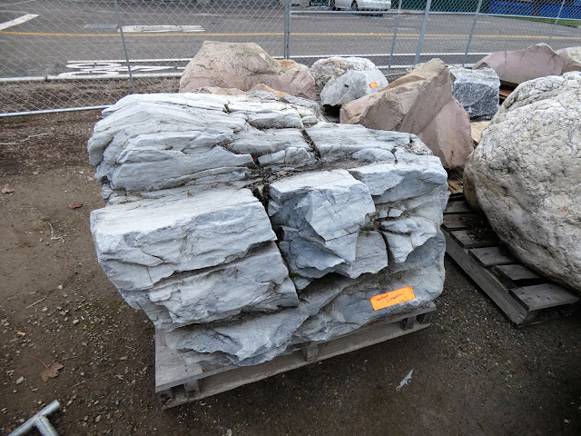
Addendum: If you are wondering what the latite rock looks like, I went out today and got a few shots of it.


Monday, April 13, 2020

A Day on the California Prairie: Finding the Precious Places Near Home


Yosemite National Park is closed. The coastline is closed. The state parks are closed. Am I complaining? Not in the least. We are facing an unprecedented threat, so we must curtail our freedoms a bit until the scientists and the doctors (and all of their heroic support staff from nurses to foodworkers to custodians) can do their work protecting us. And we must continue to do our part, isolating ourselves from each other, and from the virus itself. I pray that you are able to stay healthy and safe, and if tragedy strikes, that you find peace in some way.
In the meantime, there are a few legal ways to maintain sanity. Exercising in isolation from others near home is one way. If the city parks are crowded, find a deserted road on the edge of town to walk along. It is a way that we can find the precious and undiscovered treasures that have always been just outside our towns. As it turns out, some treasures are ephemeral, lasting only a few weeks.
My town lies on the edge on one of the few remaining largely untouched prairies left in California. These prairies used to extend across the entire Great Valley, but agricultural development has displaced 95% of the grasslands. There are a series of wildlife refuges up and down the valley that protect some of the remaining wildlands or rehabilitated farmlands. The rest of the prairie tends to be found on the margins, in the foothills of the surrounding mountains where the soils are too thin to support agricultural development.
The rainfall this year has been perilously low, with not a drop in the entire month of February. But March and April saw a resurgence in precipitation and the drying sprouts reawakened, and flowers have appeared in abundance throughout the Sierra Nevada foothills.
We took a drive through the prairie that remains between the Tuolumne and Stanislaus Rivers, and were treated with an explosion of color. I'd love to say I was an expert botanist and tell you all the species, but beyond lupines and poppies, my knowledge of flowers is sadly lacking. What I enjoyed today was the profusion of color.
We are living in one of the most challenging times many of us will ever experience short of all-out war. Natural disasters horribly affect particular regions, but there is always help from elsewhere, and there are places of retreat and refuge if an earthquake or hurricane strikes. But this one is a worldwide viral attack, and all we can do is shelter in place until it passes. It's scary, it's dangerous, and many are suffering. I hope there are a few moments of peace and serenity to be found here in these little treasures close to home.

Thursday, December 6, 2018

Wait a Minute...What Happened to the Rocks I Picked Out?

Something kind of extraordinary happened on campus this week. I was pausing between classes and saw a large truck and a crane downstairs in the staging area for the Great Valley Outdoor Nature Lab. The crane was dumping gigantic rocks onto the ground. "My" rock collection had arrived!! You might remember that early last month I went 'rock collecting' in the Sierra Nevada foothills for the rocks that will be part of the displays and landscaping of the outdoor. All 60 tons or so...
Source: https://media.giphy.com/media/12ScDYWbP4yoBq/giphy.gif
My response about their arrival on campus was predictable...

But if you remember the scene in "Elf" when Buddy thought Santa was in the store only to discover he was a fake, well, I had that moment too. I saw that something was off about the rocks I had selected. Something was different about them. Below was the rock that I selected a month ago, when it was 85 degrees out, and rain had not fallen in months...
And here (below) is the rock they claim I picked out. This after nearly two weeks of rain and cooler temperatures. This rock is clearly on a PALLET of LIES!

Well, okay, maybe it isn't on a pallet like the others, and maybe it is the same rock I picked out. But you can now see one of the main reasons I picked it, and why it will be sitting in a position of honor by the entrance sign to the outdoor nature lab. Not only is it a unique rock that is found in our region (the latite of Table Mountain), it is also a miniature ecosystem of mosses, lichens, grass, and other organisms. To see it, just add water!
In any case, we now have an astounding variety of the rocks that are found in our region. There is marble from the Calaveras Complex, the host rock of the many caverns that are found in the Sierra Nevada foothills.
There is a gigantic chunk of the quartz from the Mother Lode veins, the source of the gold that played such a huge (and devastating) part in the history of California. Sorry, no visible gold (although I'll keep looking).
One of the most striking rocks are the "tombstone rocks" of the Foothills Terrane, large fins of slate and phyllite that were once mud and silt on the ocean floor. The rocks were crushed against the western edge of North America, metamorphosed, and tilted vertically. We'll be putting them in the ground in the same vertical orientation. It will be a dramatic sight at the southern entrance to the lab.

The next step comes at the end of the week. I'll get to help direct the placement of the rocks! I'll try not to be insufferably picky..."Could you rotate that one about four inches? Great! Wait...I liked it better the way it was...". An update will follow.

Friday, November 2, 2018

I Went Rock Collecting Today...For Really, Really Big Rocks

I'm thinking how many times I've been on a field trip looking at a massive boulder composed of some kind of interesting rock and making a joke about how we would need a crane to get the thing back to school. I'll be darned if that very thing didn't come true today.

I was up in the Sierra Nevada foothills, choosing out some really big rocks, and we may very well be using a crane to move them back to campus. At least one of them weighs about 3 1/2 tons, and in total there will be about 60 tons of them. So yes, maybe my rock collecting habit has gotten out of hand. I need professional help.
Well, I might need professional help for something, but it's not for a colossal rock-collecting habit. I was selecting rocks representative of the geology of the Sierra Nevada foothills to become part of the landscaping of our new Great Valley Outdoor Nature Lab that is being constructed right now adjacent to the Great Valley Museum at Modesto Junior College.
At this particular quarry near Knight's Ferry on the Stanislaus River I was selecting boulders of Table Mountain latite (a volcanic rock broadly similar to basalt). These are the rocks that make up the dramatic inverted stream that winds its way among the towns of Sonora and Jamestown along Highway 108. I was also picking out some large granite and greenstone boulders to representing the bedrock found in the Sierra Nevada. We'll also be choosing some of the unique metamorphic "tombstone" rocks that stick out of the ground across the Mother Lode.

Meanwhile back on the campus of Modesto Junior College the outdoor nature lab is starting to take shape. We live in a flat valley, but the lab will have some topography, some small hills at the east end to represent the foothills. They will be planted with native trees and shrubs, and the trails and pathways will be lined with the rocks and boulders that we selected today. One of these days, the lab might look something like the scene below (which is actually at the quarry; they're showcasing what can be done with their rocks). It's incredible that the lab is finally happening. The science faculty at MJC have been fighting for an outdoor lab for three decades. It's been hard to be patient!

Sunday, April 19, 2015

Where the Rivers are "Upside-Down": A Hike to the Stanislaus Table Mountain

Around 10 million years ago, a lava flow surged from a volcano near present-day Sonora Pass in the Sierra Nevada. Composed of latite, but non-viscous like basalt, it flowed off the volcano and into the channel of the ancestral Stanislaus River, eventually flowing close to sixty miles. The river eventually eroded another valley and the lava flow was left relatively intact. The Sierra Nevada rose and tilted westward, and erosion removed the surrounding softer rock, leaving the former river valley as a ridge several hundred feet high. This was the origin of the Stanislaus Table Mountain, an inverted stream.
In this GoogleEarth image, the trail mostly follows the white line along the base, and then climbs the forested slope on the right.
Table Mountain forms a mesa-like ridge around Sonora and Jamestown in the Mother Lode of the Sierra Nevada. A lot of it is on private property, and as such is inaccessible for close investigation. But one portion lies within the boundary of the U.S. Bureau of Reclamation lands around New Melones Reservoir. The Bureau has constructed a trail to the summit, and that's where we were headed today on our Geology Club hike.
The trail is about 1.5 miles in length, and the first mile is a gentle grade through meadows and oak woodland. The grass was still green and wildflowers were reasonably abundant, but it isn't going to last. The soil felt bone dry, crunching under our feet. It's going to be a long, hot summer.
For the last half mile, the trail becomes increasingly steep. It's a climb of several hundred feet to the top of the lava flow. It was hot today, nearly ninety degrees, and I was appreciative that our trail was on the shaded north side of the lave flow. Oak trees provided shade, but also obscured the view but for a few choice moments.
The view provided us with confirmation of our progress up the mountain. But near the top the trail became a near scramble up the rocks. The short-cuts of use were hard to distinguish from the actual trail, as both were so steep.
The scramble was short, however, and we broke out into the barren surface of the top of the inverted stream. It was an alien landscape. Alien in the sense that it was covered mostly with actual native vegetation, unlike the grasslands below, which have been taken over almost entirely by European or Asian invasive grasses. The invasive species cannot compete in this harsh, mostly dry habitat. It was most certainly dry on this day, as we have had few rainstorms since February.
These rocky flats sometimes contain vernal pools and swales, and constitute one of California's rarest habitats. This section of the flow is one of the only protected portions of this type of landscape. The pools exist for only a few weeks at a time in the winter and spring seasons. At least one of the flower species here is found nowhere else in the world. In spite of the intense dryness, a few flowers persisted here and there, including on the shaded north slopes.

The top of the flow was a fine lookout for views in all directions.

The cliffs drop off steeply on both sides. The local casino lies directly below, and the abandoned open pit Harvard Mine lies just to the east.
To the north lies the nearly dry New Melones Reservoir.
It's a strange and wonderful environment on top of the lava flow, one that is quite different than any found elsewhere in the state. We explored the summit area for awhile, had lunch and started down the trail back to the road.
We visited Table Mountain in an entirely different time back in 2011. We arrived in a wet year, and hot on the heels of an overnight rainstorm. It's hard to describe just how different the scene was on that trip. There were pools and rivulets all over the summit area, and hundreds of small waterfalls cascaded over the cliffs. Flowers were everywhere. It was a totally different experience.
Here are a few scenes. For more, check out these posts from 2011:http://geotripper.blogspot.com/2011/03/day-in-fieldday-backwards-on-fun-having.html, http://geotripper.blogspot.com/2011/03/day-in-fieldday-backwards-on-fun-having_22.html and http://geotripper.blogspot.com/2011/03/day-in-fieldday-backwards-on-fun-having_23.html

Thursday, March 14, 2013

Adventures in a Roadcut: It's All in Your Point of View


It's March in Central California, which makes for a really fine time for a geology field trip. We headed east into the Sierra Nevada foothills for a look at some Mother Lode history. For those of you not familiar with the history of California, the Mother Lode was the site of one of the world's greatest gold rushes, starting in 1848 with the discovery of gold flakes in the American River by James Marshall. Ultimately several hundred thousand people made the difficult journey to California to try and find their fortune. As is often the case with such things, only a few ever really prospered. We traveled through Hornitos, an off-the-beaten-track gold era town with some beautiful old ruins, and then followed Highway 49 from Mariposa to Coulterville and then to the hills near Jamestown.
The sun was getting low in the sky when we reached our last stop of the day on Peoria Flat Road outside of Jamestown. It's a neat little mystery for the students to work with, and a great lesson in the need for alternate points of view when problem-solving.

We had spent much of the day in typical rolling hills of the Mother Lode, and crossed several deep gorges, including the Merced River which flows out of Yosemite Valley. When we reached Peoria Flat, the landscape was different. The hilltops were flat and barren, even mesa-like. The flat hills were topped with some kind of dark brown rock that was unlike any of the the slate and serpentine outcrops we had been seeing all day. We found a spot where the road crossed through the flat-topped ridges and had a closer look at the dark rock and the sediments underneath it.

The students found that the dark rock was volcanic, and unweathered surfaces were nearly black. At their level (physical geology or historical geology), black volcanic rock usually equals basalt, though additional study would show the actual composition of the rock to be more along the lines of latite or trachyandesite. The rock underneath the ridge turned out to be conglomerate, with clasts composed mostly of a variety of rounded volcanic rocks. They were clearly deposited in a river. So we had something strange: a flat-topped hill composed of river gravels and topped by a volcanic flow. How did a riverbed and lava flow end up as a ridge?

The best clue to understanding this strange relationship is a different point of view. Several years back, a friend with a plane invited me on a flight over Sonora and Jamestown, and we flew right over the strange outcrop. I knew exactly what I was seeing because Table Mountain is a famous example of an inverted stream.

Nine or ten million years ago, the Sierra Nevada was a lower mountain range with a series of volcanic centers near the crest at Sonora Pass that would have resembled a region like Lassen Volcanic National Park. One lava flow was unusually long, some 60 miles, and as such had followed a stream canyon that had been occupied by the ancestral Stanislaus River. The lava displaced the river to something closer to its present pathway, and as the mountains rose and tilted to the west, erosion stripped away the softer rocks surrounding the lava flow. The old river bed became the flat summit of the Stanislaus Table Mountain; it had become an inverted stream.
You just have to look at the problem from another angle.
It was a beautiful day, and the flowers are ready to bloom. It's a really good time of year for geology problem-solving!

Wednesday, March 23, 2011

A Day in the Field...Day Backwards On Fun Having, Part Three. Stanislaus Table Mountain from above

The conclusion of my backwards mini-series on the Stanislaus Table Mountain starts with an earlier trip that will serve to explain the origin of the backwards geology of our hiking destination from last weekend (parts one and two here and here). The picture above reveals our path from a slightly different point of view, mainly from several thousand feet above. Back in 2002, the father of one of my students called me early one morning and said "Let's fly my plane. Where do you want to go?" I immediately thought of Table Mountain, because it is best seen and appreciated from the air.

I've been saying "backwards" a lot in these posts, but the actual term we want to use here is "inverted", as in "inverted stream". Our hike was to the top of a lava flow that sits hundreds of feet above the surrounding landscape. On first glance, this may not seem to make much sense. The key to understanding this oddity is to realize that the lava flow did not start out on top of a ridge.

Around 6 to 20 million years ago, volcanic activity was producing ash and lava flows in the summit region of the growing Sierra Nevada in the vicinity of Sonora Pass and the Dardanelles. The earliest volcanic activity included violent explosions of light colored rhyolite ash that coated the Sierra foothills (the Valley Springs Formation), but later eruptions mixed with water and snow to form volcanic mudflows (called lahars). These mudflows and river deposits coated the foothills region hundreds of feet deep, a series of layers called the Mehrten Formation. In the picture above, the layers form contours on the sides of the hills. For those familiar with the Knights Ferry area, the Mehrten forms the cliffs of Lovers Leap.

In the midst of this activity, about 10 million years ago, a single flow of latite (a sort of orthoclase bearing andesite) traveled more than forty miles down the western slope of the rising mountain range. Having flowed far beyond any volcanic slopes, the lava followed a riverbed, an ancestral path of the Stanislaus River. The picture below reveals the winding path the lava followed (our hike was located right in the center of the photograph). The surrounding rock was easier to erode than the latite, so when the mountains continued to rise, the lava flow remained while the other rocks were carried away. The bottom of the river became the top of the ridge: a textbook example of an inverted stream.

Farther "downstream" the lava flow widened considerably, forming a more plateau-like landscape. The Stanislaus River ended up carving through and around the lava flows. Some of the steep gorges became idea sites for modern-day reservoirs, like New Melones and Tulloch, seen below. The Table Mountain lava flow disappears beneath the slopes around Knights Ferry.

I mentioned in the previous post looking over towards the Harvard Mine from the summit ridge of Table Mountain. The open-pit mine was active from 1986 to 1994, producing about 660,000 ounces of gold from about 17 million short tons of rock. The lake in the pit is about 300 feet deep. Just prior to closing down, the miners recovered a huge mass of crystallized gold, weighing more than 40 pounds. The gold is on display at the Ironstone Winery in Murphys.

It was a lot of rock that was removed and piled up to get at the gold. So not only is the local landscape inverted, it has also been turned inside out.
I hope you've enjoyed these vignettes of my pair of journeys to a backwards landscape! The flight was made possible by Ken Iwahashi of KKI Corporation in Modesto. I have a web page with additional pictures and descriptions of the flight at Geotripperimages.com.

For more on the volcanism of the Central Sierra Nevada, check out:

Busby, C.J., et al., 2008, The ancestral Cascades arc: Cenozoic evolution of the central Sierra Nevada (California) and the birth of the new plate boundary, in Wright, J.E., and Shervais, J.W., eds., Ophiolites, Arcs, and Batholiths: A Tribute to Cliff Hopson: Geological Society of America Special Paper 438, p. 331-378.