Monday, April 9, 2018

The Difference a Day Makes: Yosemite 24 hours after the Deluge

Photographed by Garry Hayes


First off, thank you to the National Park Service for making the flood photographs available on their Facebook page. And second of all, kudos to the National Park Service for weathering the flood and opening the park again so soon afterwards.

I was in Yosemite Valley today, leading my students on a postponed field studies class in the park. Why did we postpone the trip? Well, mainly it supposed to take place on Saturday, but it turned out that the valley was in the midst of dealing with one of the larger floods it has experienced, about the fourth or fifth largest in 30 years or so. Plus, they closed and evacuated the park in advance of the storm. They only opened up again at noon today, and we were at the park boundary at precisely 12:11 PM.

The storm was epic. It was an atmospheric river storm, a "Pineapple Express" that brought many inches of very warm rain to a snowpack that had fallen only in the last few weeks. Rain was falling at elevations as high as 10,000 feet. The runoff gathered quickly into the streams and rivers, and the Merced went from around 1,000 cubic feet per second to more than 12,000 cfs. Water level at the Pohono Bridge gaging station rose from 5 feet to almost 14 feet. For reference, official flood stage begins at 10 feet, and at 12 feet the main valley roads are covered with water. It could have been a disaster if the valley had been full of tourists.
Source: https://www.cnrfc.noaa.gov/graphicalRVF.php?id=POHC1

But instead, the weather cleared, and the park service maintenance people worked quickly to clear debris from the roads and bridges. It couldn't have been easy, and there were lots of anxious tourists hoping their vacations wouldn't be totally ruined. They came through, and now you can compare the difference 24 hours can make.
Source: National Park Service

24 hours ago, clouds obscured the cliffs, and one could barely making out the raging torrents of Upper Yosemite Falls. This afternoon, there was not a cloud in the sky, and while slightly diminished in volume, the falls were as powerful as they will probably be for the rest of the year.
Photograph by Garry Hayes

The river rose to cover Cook's Meadow, but as the sign shows, nowhere near the level of 1997's even more epic flood. The discharge was twice as high then as it was yesterday, at 24,600 cubic feet per second.
Source: National Park Service
Today the sun shone brightly on a still-flooded meadow, but the water had receded enough that we could follow the boardwalk across the open space.
Photograph by Garry Hayes

I may be posting more pictures soon, but I had to lead off with these since by chance I was standing close to where the photographer was standing yesterday.

Saturday, April 7, 2018

Red Fox Family on the Tuolumne River

Be warned: cuteness alert. I was out on the Tuolumne Parkway Trail this afternoon, checking things out after more than two inches of rain in two days. It was sunny and lots of birds were out and about, but just before I got to the end of the trail, I saw something I've never seen before: a fox family.
I've seen foxes a number of times over the last three years. One fox that I photographed early on was actually used on the interpretive signs for the trail. I could never figure out from year to year if I was looking at a family or not because I never saw more than one at a time.
I haven't seen the foxes for many months now, and I was worried that they might have moved on (silly me). Finally in the last few weeks I've noticed an acrid odor that I suspect was related to the foxes, so I've been watching the grass and shrubs much more carefully. Today, though, I came face to face with the one in the first picture above. I couldn't distinguish the size very well, but I noticed the shorter face and realized it was a pup. A moment later a second head popped up! I didn't get a good shot of both of them at once before they disappeared into their den. It occurred to me that momma must be around somewhere, and then I realized she was in plain sight up on the log above. As you can see in the photos, she was very nervous about me (she could barely stay awake, actually). I've seen momma in previous years; she was wounded in one eye, giving her a distinctive appearance
Red Foxes are one of the most widespread carnivores on the planet, being found across the northern hemisphere. The populations in California are a mixture of native and non-native individuals. The rarest is the Sierra Nevada Red Fox, which is only found in the northern Sierra and southern Cascades at high elevations. It was recently sighted in the vicinity of Sonora Pass, north of Yosemite. The populations in the Central Valley were thought to be escapees from fur farms, but recent work has determined that the valley north of Sacramento has an endemic population. There seems to be little if any information about native Red Foxes in the south valley. There is a native species, the Gray Fox, which I have seen once or twice along the river. There is also the rare and endangered San Joaquin Kit Fox, which I have never seen.

I hope I'll have a chance to watch them grow up!

Liveblogging the Deluge: Merced River in Yosemite Reaches Flood Stage

This picture is a cheat. I'm not in Yosemite, this picture is from two years ago
I was supposed to be in Yosemite right now. We had scheduled a field studies class today that would have sent us up the Merced River to Yosemite Valley and back, but nature has intruded with an unusual April atmospheric river storm that is setting some daily rainfall records across Central California. San Francisco, for instance, received rain equivalent to an average April in a single day. My backyard rain gauge in the Central Valley has recorded 2.2 inches since yesterday. In 26 years of measuring, there have only been three Aprils where we've received that much in the entire month.

I had already decided to postpone the trip by last Monday when the forecasts called for flooding on the Merced River in Yosemite Valley. In short, the river jumps its banks at the 10 foot level (about 6,000 cubic feet per second). At 12 feet (9,500 cfs), the flooding river covers some of the main roads in the valley. Today's storm is expected to result in a river that crests at 14 feet, or 14,000 cubic feet per second. Even if I had decided to go ahead with the field trip, we would not have reached our goal, because the park service closed Yosemite Valley yesterday. We're going to try and make the trip tomorrow to check out any flood damage, but if the valley floor is still closed, we'll try to see Hetch Hetchy instead.
Yosemite Valley is especially prone to flooding because it is high up in the mountains close to the headwaters of the Merced River, and when rain falls, it falls on mostly barren granite. The water flows into channels very quickly, and the channels gather into the Merced River and Tenaya Creek just as quickly. There are no reservoirs upstream for flood control (nor should there ever be).

If it drives home the point, Yosemite Valley has only been closed a few times in its history, most notably in 1997 during the unprecedented floods of that year, and during a few government shutdowns. It takes a major event to convince the park administration to shut down the iconic valley.

I hope to be back tomorrow with pictures of Yosemite Valley. We'll see what happens! I will update the flood hydrograph in the space below when the river flow peaks.

UPDATE: At 1:00 PM, the river has reached 10,800 cubic feet per second (12.85 feet). If I'm reading the data right (below), this is only the fourth time the flow has reached this level since 1996.

Here is the 1:00 PM report:

Also, here is a link to video of the main road in Yosemite Valley at the moment, courtesy of the Fresno Bee.

UPDATE 2: We've reached 12,100 cubic feet per second as of 5:00PM, and 13.68 feet (10 feet is flood  level), and the flood may be peaking. The discharge only increased by 100 cfs in the last hour.

FINAL UPDATE: It looks like the flood has peaked at 12,100 cfs, as it has been there for two hours. I expect it will now start dropping. I'm hoping the valley will reopen in time for our visit tomorrow. If not, I guess we'll check out Hetch Hetchy!

WELL, OKAY, ONE MORE UPDATE: Yosemite National Park has posted pictures of the flooding today: https://www.facebook.com/pg/YosemiteNPS/photos/?tab=album&album_id=1650167855031490

Friday, April 6, 2018

An Incredible Spot in the Mojave Desert, the Hole in the Wall. You could see it for yourself this summer

Summer is coming soon. If you are casting about wondering what to do, how about the adventure of a lifetime? Our department is offering a dyad class, Geology 191/Anthropology 191, the Geology and Anthropology of the Colorado Plateau, and it is an incredible chance to check out some marvelous geology along our southwestern tier of states: California, Arizona, Colorado, Utah, and Nevada. I want to give you a bit of a preview of the kinds of places we will be visiting...
The Mojave National Preserve is one of our nation's newest parks (established in 1994). It was carved out from Bureau of Land Management lands in the eastern Mojave Desert, preserving one of the most awesome sand dune complexes in the country, the Kelso Dunes, a barren landscape of geologically recent volcanic cinder cones, one of the largest Joshua Tree forests in existence, and some of the highest mountain ranges in the Mojave Desert, with rocks as old as 1.7 billion years old, as ancient as those in the bottom of the Grand Canyon. The preserve also encompasses a California State Recreation Area, the Providence Mountains, and Mitchell Caverns, a unique limestone cave system. The caverns were closed during the recession, and then severely vandalized, but they have finally been reopened for visitation (see this Facebook page for updates).
One of the most interesting corners of the park is called Hole in the Wall, along with Banshee Canyon. We will be staying at the nearby campground our first night on the road on June 2. It is a wonderfully isolated spot, 25 miles off the main highway, and even farther from developments of any kind. It has some of the darkest night skies I've ever seen, and it is serenely quiet (except for crickets and coyote yowls).
The region is quite unlike other parts of the Mojave. Instead of deeply eroded mountain ranges and wide flat valleys, the area around Hole in the Wall is composed of mesas and plateaus that seem to share more in common with the Colorado Plateau province just to the east. But these mesas aren't like Arizona's either. They are composed not of sedimentary layers, but of volcanic tuff, rock derived from unimaginably huge volcanic explosions the likes of which modern humans have never experienced.
Twenty million years ago, the region was one of low relief, the result of tens of millions of years of erosion and relative stability. But conditions were changing as the crust was stretched and broken up into a series of tilted fault blocks. The release of pressure on the underlying mantle allowed partial melting to take place, and volcanic activity exploded across the region.
The first eruptions took place about 18.5 million years ago when the Peach Springs tuff coated the entire region from an eruption center near Oatman, Arizona. The eruption involved as much as 150 cubic miles (640 km3) of powdery white ash that was so hot that in many places it welded into solid rock as it landed.
Shortly afterward (in geologic terms anyway, as it was 700,000 years later), a second caldera developed. It was located even closer, in the adjacent Woods Mountains. The eruptive "crater", actually a collapse pit, was about 5-6 miles across, roughly similar in size to Crater Lake. Once again, all life was obliterated for hundreds of square miles as hot ash blanketed the landscape. The Wild Horse Mesa Tuff makes up most of the rock found at Hole in the Wall.
The strange holes that gave Hole in the Wall its name are called tafoni. Small differences in the degree of solidification or cementation cause depressions to form which end up staying wet longer, and the minerals decay into small fragments that can easily wash or blow away.
A short trail (1.5 miles) loops around Banshee Mountain and explores the best of the eroded tuff. Starting at the small visitor center, the trail drops through a rugged narrow canyon. There are some drop-offs, but rings have been attached to the canyon wall, making it a lot easier to climb up or down. Once past the narrows, the trail has a gentle gradient, and provides interesting views in all directions. There is a nice collection of petroglyphs on some of the boulders around the south end of the mountain.
If you want to visit this fascinating corner of the desert with us this June, please check out the previous post for details. We will be on the road for two weeks, and this will be only the first of many wonders that we will explore.

Wednesday, April 4, 2018

The Most Extraordinary Landscape on Planet Earth: Geotripping on the Colorado Plateau, June 2-17, 2018

North Rim of Grand Canyon National Park

There is no place on this planet like the Colorado Plateau. It's hard to find anyplace else on Earth where the crust remained relatively stable for upwards of a billion years, accumulating several miles of horizontal sediments, only to be lifted up rapidly in the last few million. The Colorado River and her tributaries then stripped away much of the sedimentary cover, and cut deep into the underlying metamorphic rocks. Those metamorphic rocks record a violent geologic history of colliding landmasses and mountain-building. The resulting landscape is one of the most beautiful places imaginable.
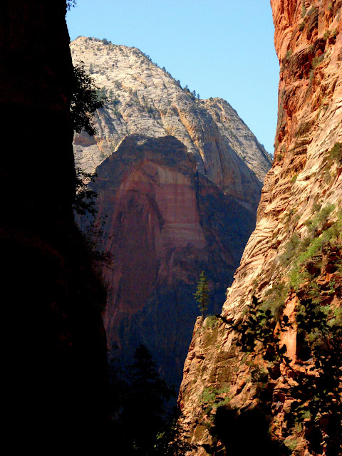
Angels Landing Trail in Zion National Park, Utah
The plateau country is a training ground for geologists and earth scientists, and has been since the days of John Wesley Powell and Joseph Ives, who were the first to lead research parties into the region (they didn't "discover" the plateau, of course; Native Americans have known the region for thousands of years). If you are curious about learning geology in this incredible region, you might consider joining us as a student (of any age) on our geology field studies course Geology 191, offered under the auspices of Modesto Junior College in Modesto, California. The course is designed to fulfil the curiosity of lay geologists and archaeologists, but also to build the skills of geology and archaeologists as well.
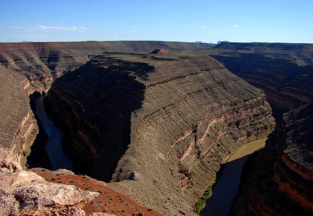
Goosenecks of the San Juan River, Utah
Our field course will be a grand loop through the plateau country, with investigations of the Mojave National Scenic Preserve, Grand Canyon, Zion, Bryce Canyon, Arches, Canyonlands, Capitol Reef, Black Canyon of the Gunnison, Mesa Verde and Great Basin National Parks, as well as many monuments, including Bear's Ears, Grand Staircase-Escalante, Natural Bridges, Navajo, Hovenweep, and Colorado National Monuments. It will be an unforgettable two week trip from June 2-17, 2018, beginning and ending in Modesto, California. Information can be found soon at my school website at http://hayesg.faculty.mjc.edu/Geology_191_Colorado_Plateau.html .
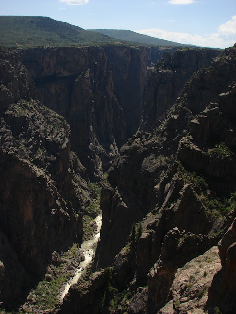
Black Canyon of the Gunnison National Park in Colorado
It's not a comfortable trip...we travel in school vans (which of course are known for their luxuriousness!), we camp every night, and the days can be hot, windy, cold, or stormy, and we are out in the middle of anything that happens. But we are staying in beautiful places each night, and there are even showers and laundry available every third day or so! Extensive hiking is not required, but there will be many chances to explore the trails in each park and monument.
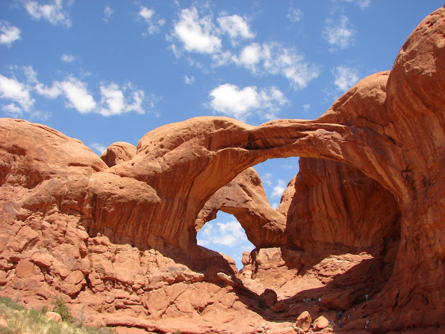
Double Arch in Arches National Park in Utah
Geology 191 is a 3 semester unit course which will be taught as a dyad with Anthropology 191 (also 3 units). By end of the course, you will be able to see the landscape the way geologists do: by identifying rocks, minerals and fossils, and interpreting the geological history of an area by working out the sequence of events as exposed in outcrops. If you are a science teacher, you will come home with a collection of photographs that illustrate most of the important principles of geology, and a selection of rocks, minerals and fossils that will make a great classroom teaching tool (legally collected, of course; there are many localities outside of protected parks from which to collect samples). The dual nature of the course means that you will also have a mastery of the archaeology of the plateau region, the home of the Ancestral Puebloans, the Fremont people, the Navajo, the Utes, and others.
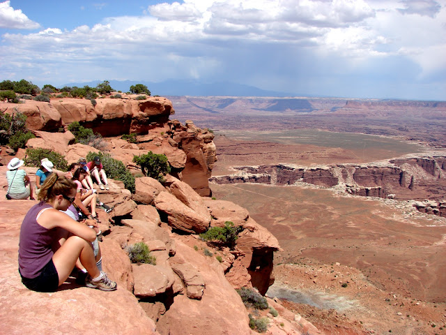
Canyonlands National Park, Utah
The cost of the trip will be $850.00 plus the cost of tuition (Currently $46 per unit for California residents, and $222 per unit for out-of-state residents). The cost includes transportation, food, camp fees, and entrance fees. Participants would want to bring a few dollars along for showers, laundry, and souvenirs.  The food is tasty and plentiful (everyone helps cook and clean!), and the school vans...are vans.

For those of you who live in the Modesto region, we are having an organizational meeting on Monday, April 16 in Room 326 of the Science Community Center on the west campus of Modesto Junior College from 6:30-7:30 PM. If you are unable to make it to the meeting, you can contact me for details and handouts.

If you are not in the area, we will be glad to arrange for transportation from nearby airports and train stations (we actually have an Amtrak station in town). Enrollment can be completed online once you are registered with the college (http://www.mjc.edu). Please contact me through the class website if you have any questions.
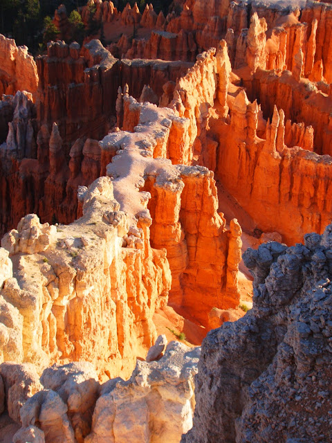
Bryce Canyon National Park
Hope to see you out there, back of beyond!

Monday, April 2, 2018

A Shaggy Sheepdog Story for an April Fool's Sunday

This was just a little fun I had today, although I had a moment of worry, wondering about the wrath of a wary guard dog. We've visited the San Luis National Wildlife Refuge several times in the last few weeks. The refuges seek to maintain an environment conducive to the survival of the native birds and other animals of the Central Valley. Unfortunately over the years, many of the native species have disappeared or have been displaced. This is especially true of the big grazers. The valley once hosted mammoths, mastodons, bison, horses, camels, and pronghorns.
So the rebuilding of the natural grasslands involves returning native species of grass, and to the extent possible, the return of larger grazing animals. The managers will often allow the limited grazing of the prairie by domestic sheep and cattle. We've been seeing a herd of sheep on our recent visits. We haven't seen the human shepherds, but we've noticed the herd's protectors: some rather large sheep dogs. I think they are a breed called Maremma or Great Pyrenees.
And the sheep do need protection. Their natural defensive nature has been largely bred out, and they don't really know how to face down predators like the coyotes we've seen in the vicinity of the sheep herds.

So, we were there again today, enjoying the beautiful spring weather and the birds, and even a few newly born lambs in the sheep herd. We got to the southeast corner of the Waterfowl Auto-tour, and found out that the sheep dogs recognized us as a possible threat to the sheep. They actually jumped a fence, slogged through an irrigation canal, and loudly barking and growling, chased our car down the road to the Souza Marsh. They finally seemed to lose interest and fell behind. We parked and I walked around for a few minutes. Then I turned to walk back to the car...and came face to face with a very large sheep dog! Those crafty little beasts had snuck up on us and had me trapped in the open.
I actually got bit by a panicked dog a couple of weeks ago, so I was painfully aware of what a dog bite can feel like. I was more than just a little nervous. Luckily, Mrs. Geotripper was already in the car, but I was frozen in place. I finally realized they weren't barking, just watching. I walked slowly to the car. The dogs allowed me to get in the car without making a sound. And then: they herded us out of the marsh and away from the sheep flock, with one dog on either side of the rear of the car. Not a growl or a bark between them. They walked us almost a quarter mile in a highly disciplined manner.

I fear for the well-being of the coyote who decides to go up against them.

So, there you go for an April Fool's Day, a shaggy dog story, but without the painfully stupid pun at the end. At least none that I could think of in the spur of the moment.

Sunday, April 1, 2018

In the Red HIlls Area of Critical Environmental Concern, a Promise of Spring (and a rare fish)

We saw exactly two poppies blooming. In a few weeks there will be thousands.
It has a clumsy name that only a bureaucrat could love, but the Red Hills Area of Critical Environmental Concern is a fascinating place in the Sierra Nevada Mother Lode. It was for decades a sullied hidden treasure, used for dumping and target shooting. But as biologists and geologists started to study the region, they found a unique biological island in the normally oak-studded woodlands of the Mother Lode.
The uniqueness of the area was tied to the underlying soil, developed on the serpentine and ultramafic rocks of the Foothills Terrane, slices of the ocean crust and rocks from deep in the Earth's mantle that had been added to the western edge of North America some 200 million years ago. Serpentine soils lack many of the nutrients required by "normal" plants like grass and oak, but are loaded with metals that are actually poisonous to plants as well. Plants that survive in this strange other-worldly land have to be tolerant of this harsh chemical environment.  Some of them are very rare, and a few are endemic, found nowhere else in the world. Because of the prevalence of iron, the soils are usually a deep reddish brown, giving the hills their name.
This was the single Monkey-flower we found. There will be many more!

The delineation is sharp. When one turns off of LaGrange Road onto Red Hills Road one sees oak woodlands and open fields thick with grass. But only about a mile in, the oak and grass suddenly give way to Ceanothus shrubs and Gray Pine. Grass is almost nonexistent, with various flower species making up the ground cover. Much of the year the ground cover is dead and dry, but for a few weeks in the spring, the hills burst into color, and there is a spectacular show of wildflowers, dominated by Monkey-flowers and Poppies.
February was an incredibly dry month, no doubt delaying the onset of the spring flower show, but the heavy rains of March have left the soils wet, and sprouts are popping up everywhere. We were there today to look things over, and we could see that land is about to burst forth in another week or two.

I wandered over to the creek to see if the fish were around. The Red Hills host a rare and endangered subspecies of the California Roach, the Red Hills Roach (Lavinia symmetricus). The fish were for a short time thought to be extinct when the extended drought dried up the intermittent creeks that they called home. But a few spring-fed pools persisted during the driest times, and the fish are doing okay.

They were in a frenzy of feeding or breeding, or just doing some heavy partying when I found them. I caught some video below. All in all, life is returning in the foothills during these brief weeks before the hot dry times come again all too soon.

Happy Easter, all!