Wednesday, October 1, 2008

The Real Jurassic Parks: Goblin Valley and the Entrada Sandstone


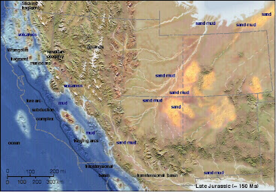
This paleogeographic map is courtesy of Ron Blakey at Northern Arizonal University

Welcome to one of the most unusual (and most isolated) parks in the American Southwest, Goblin Valley State Park. It is located in south-central Utah, miles from anywhere (the relative metropolis of Green River, population 973, is about 50 miles away). It is a fine introduction to the Entrada Sandstone and Summerville Formation, two of the more scenic layers within the San Rafael Group.

In the latest part of the middle Jurassic (around 165 million years ago) huge changes were taking place across the American west. A subduction zone had formed off the coast of California, and compressional forces had caused the faulting and uplift of a range of mountains across Nevada. A shallow sea occasionally extended into the region from the north, leaving vast deposits of mud, silt and sand deposited in tidal flats, while in other areas river floodplains and desert dunes predominated (the region still lay across the subtropical belt, much like the Sahara today). The sediments, which have a distinctive red-brown color, are known today as the Entrada Sandstone.

In other regions, the Entrada is primarily a cross-bedded sandstone that forms distinctive cliffs, but here at Goblin Valley, the formation is more variable, with alternating layers of sand, silt and shale that erode in a differential manner, forming slopes and ledges.

The Goblins are short spires called hoodoos, which resulted from the erosion along joints and fractures in the rocks. If you are a fan of the movie "Galaxy Quest", will immediately recognize the park, and will probably be looking for cute little purple cannabilistic space aliens and immense rock monsters. You will probably be disappointed in your search, but your imagination will probably conjure up even more fantastic creatures as you wander through the goblins.

The park includes a unique campground that is nicely developed with showers and flush toilets but very little shade (there is a nice group campsite too). During the summer we make a point of arriving in the late afternoon when the sun is approaching the western horizon. The views east are expansive, and few parks in the American west offer better star-gazing. The San Rafael Swell, a huge monocline, lies just to the west. The Henry Mountains, one of the last mountain ranges in the United States to be given a name, lie just to the south. Reaching over 11,000 feet, they are a series of laccoliths, a unique type of mushroom-shaped intrusion, almost, but not quite volcanoes (although volcanoes may have once existed above them). The region is also a great place for seeing pronghorn antelope!

Tuesday, September 30, 2008

The Real Jurassic Parks: The San Rafael Group

I've been meaning to return to my continuing narrative on the geology of the Colorado Plateau; I didn't want to strand you all in the early Jurassic, as pretty as the rocks of that time are. The next layers on the plateau are a highly variable series of formations from the middle Jurassic gathered together as the San Rafael Group. A lot of geologic action was taking place throughout the region at the time, with the occasional incursion of shallow seas to the region, continuing desert conditions, rivers and floodplains, and maybe even a local asteroid impact. Some of them are formidable scenery-makers, especially the Entrada Sandstone, the subject of the next few posts.

Today's photo is an early morning shot from the campground at Goblin Valley State Park in south-central Utah, showing a unique outcrop pattern of the Entrada. It's a teaser, though. More later!

Wednesday, September 24, 2008

Done With Domes: Accretionary Wedge #13

This month's Accretionary Wedge is hosted by Goodschist, and includes a great topic, "Geologeeeeee in Spaaaaaaaace!" I have noticed that some of my favorite topics on planetary science have already been mentioned by those with far greater expertise than my own, and I look forward to reading them all in a few days. What I am doing instead is to publicly struggle with a teaching concept I have been thinking about for a few days. It has to do with our perception of the cosmos.

I spent the weekend in the Owens Valley of eastern California, and slept under the stars (I REALLY hate tents). Staring into the darkness, I could see the Milky Way stretching across the sky, thousands of individual stars, and Jupiter shining in the west. Intellectually, I know that shooting stars, planes, and satellites are phenomena of our own planet, that the planets are part of our Solar System, that there are stars in our local corner of the cosmos, and that the Milky Way is a vast distant arm of our galaxy. The Andromeda galaxy lies far beyond. But looking at the sky, I could only see a dome, painted with little dots of light which for all I could tell were equidistant from me. The ancients thought of the cosmos this way, and they made stories to go with the random arrangements of stars that formed bears and hunters and scorpions.

Even though we know we are not looking at a dome, we still take our kids to planetariums, and above their heads is ... a dome. Stars are projected onto the surface of that dome, and lots of wonderful education ensues. But kids come away thinking of the heavens as a dome. They go to summer camp, and they learn astronomy by identifying constellations, just like their ancient ancestors. And the sky remains to them as a dome. There is no true sense of vastness of the space they are seeing.


So it is that I stand in the darkness, and try to wrap my mind around the literal infinity that lies above me, and it occurs to me to try things a bit differently. If you can get to a dark place give this a try. If you have a full view of the sky, you need to lie down and change the perspective a little. If you have a view of the Milky Way, orient yourself so that it extends across your view, from left to right. Now, instead of thinking of the scene as being above you, in your mind make it in front of you. You are at the front window of a vast spacecraft flying level with the plane of the galaxy, and all the stars below the galaxy are also below you, at your feet. Only the stars above the plane are actually above you. For me, anyway, this perspective gives a three-dimensional aspect to the cosmos, and the dome disappears from view.

Doesn't work for you? Well, try something else... lay on a flat rock or a cot with a full view of the sky, and look at it with your head oriented upside down. Suddenly, you will find yourself clinging to the bottom of the planet, looking at the entire cosmos below you.

I know this particular post doesn't exactly follow this month's Accretionary Wedge; I am absolutely fascinated by new findings of liquid erosion on Titan, of ice-covered seas on Enceladus, of volcanoes on Io, and incredible explorations of the surface of Mars, and all the incredible photographs coming from the Cassini spacecraft at Saturn. But I wonder that despite the technology of giant telescopes and interplanetary spacecraft, we still stand on the ground and see the sky the same way our ancestors did millenia ago. This is a delightful and direct connection with our past, but a real disconnect between what we knew then and what we know now. Let's finally be done with domes!

Today's photo was taken on the flank of Mauna Kea in Hawaii on a perfect night.

Tuesday, September 23, 2008

Back from the Eastern Sierra Nevada


We are back from our journey to the east side of the Sierra Nevada, mostly in one piece, mostly not sore, and quite not thrilled to be back in a stuffy classroom! We spent four days touring the length of the Owens Valley, Mono Lake basin, the White Mountains, and the barren hills around the ghost town of Bodie.

The Sierra Nevada is a discrete block of continental crust that is considered to be sort of a micro-plate that is moving northwestward, stretching and breaking the crust in its wake, causing the formation of the deep fault valleys of the Basin and Range province. Owens Valley is one of the deepest of these, with a floor at 4,000 feet, and mountains on either side reaching 14,000 feet (a valley nearly twice as deep as the Grand Canyon, but not carved in any way by rivers). The Sierras include numerous granitic intrusions interspersed with roof pendants of older metamorphic rocks. The lesser-known White Mountains on the east side of Owens Valley are composed of some granite, but mostly of late Proterozoic and early Paleozoic sedimentary and metasedimentary rocks (the Cambrian sediments alone are around 3 miles thick).

Growing up, I thought the eastern face of the Sierra Nevada would be a great stand-in for the Mountains of Mordor in the Lord of the Rings by J.R.R. Tolkien. The rocks make a nearly impassable barrier for something like 100 miles with only an occasional pass at less than 10,000 feet. To say the mountains are scenic is a gross understatement...the first of today's photos is the range crest in the vicinity of Mt. Williamson near the village of Independence.

Farther north, the mountain front is only slightly less rugged, but other factors make for a fascinating geology field trip. In the center photo one can see the inland sea of Mono Lake in the foreground, some of the plug domes of the Mono Craters in the middle distance, and the high peaks just east of Mammoth Lakes on the skyline (the view is from the viewpoint near Conway Summit on Highway 395).

Mono Lake is an ice-age relic that has no outlet (a pluvial lake), so water leaves the region only by evaporating. There are no fish (it is three times saltier than sea water), but there are plenty of brine flies and their larva, and there are trillions of brine shrimp. This is a tasty mix for the millions of birds that use the lake as a stop-over on their seasonal migrations. The lake lost much of its volume when Los Angeles diverted many of the streams that fed the lake in 1942. Recent litigation has led to an agreement to bring the level of the lake to something approximating its original depth (not really, but at least enough to keep the shrimp and flies alive). Parts of the shoreline are decorated by the eerie looking tufa towers that form where fresh water springs flow into the brine.

The Mono Craters have very few actual craters. They are instead a curving line of rhyolite plug domes that began erupting around 35,000 years ago, and it is a safe bet to say they are not done yet; the last episodes of volcanic activity were only 600 years ago, at Panum Crater and Inyo Craters.

The last photo shows one of the oldest living things in existence: a bristlecone pine. Some of these trees have survived for 4,500 years in the harsh environment at 10,000 feet on the flanks of the White Mountains. The tree in the picture is not dead; a thin line of bark and a few needle-covered branches show that it still lives. It is one of the old ones, though. The fierce winter winds have abraded and polished the resin-rich wood where the bark is gone. Even the dead trees persist; a dendrochronology of the living and dead trees reaches back at least 7,000-8,000 years, giving us an accurate record of droughts and climate change over the time period.

Four days is not nearly enough time to see all the geologic wonders in this region...

Thursday, September 18, 2008

On the Road Again!

The Mountains are calling and I must go.... (John Muir)

Off to the Sierra Nevada and Owens Valley with my students! No posts for a few days. Don't know whether to wish for earthquakes or volcanic eruptions, or to hope that they don't happen out there....best wishes to the geoblogosphere!

Tuesday, September 16, 2008

It's Collect Rocks Day! I had no idea....


I found this out on a political blog of all places. It's apparently also National Cinnamon Raisin Bread Day. Since raisin bread reminds me of a metamorphic gneiss with porphyroblasts of garnet, I shall live with the strange juxtaposition...


And don't forget to take this rock-hounders safety test:

Monday, September 15, 2008

Blogging A Bit of Rock Art...

Took a brief foray into the Franciscan Complex and Salinian Block this last week...normal people call the region Big Sur, and there can hardly be a more spectacular coastal stretch anywhere (I know there is a lot of competition, though; I'd love to see your favorite photos). I came across a delicate bit of coastal rock art I thought I'd share.

I thought of providing a bit of artistic critiquing, but mostly I simply enjoyed the fragile balancing act, and I pass it on to you. The larger balanced boulder is a chunk of Salinian granite sitting on a much larger boulder of Franciscan chert. The small disk-shaped topper may be a little chunk of graywacke. I appreciated the artist's juxtaposition of the major elements of the local geological relationships.