
Of course this post isn't about THAT kind of spit. It's something very different. Take a look at the picture above. It's the Dungeness Spit Lighthouse on the Olympic Peninsula in the vicinity of Port Angeles in Washington. If the picture is a little fuzzy, it's because it was taken at extreme zoom. So we'll back up a little. Those snow patches in the distance are on the slopes of Mt. Baker, a stratovolcano of the Cascade Range.


What is this five and a half mile strip of land made of? As it turns out, it's mainly sand and gravel. And that is what a spit is, a long narrow strip of sand connected to a shoreline and extending out into the water. The Dungeness Spit is the longest spit in the United States (Long Beach in southern Washington has the appearance of a spit and is longer, but it is partly composed of solid bedrock beneath the sand and doesn't quite meet the definition).

Sand migrates along shorelines because waves often wash up the beach at an angle but flow straight off the beach. In that way, the sand zig-zags along the beach in a process called longshore transport or beach drift. The movement of sand is continuous, and if the beach sands aren't replenished by river sediments the beaches can become more narrow or disappear entirely (dam building in the last century on most major rivers has led to beach declines across the country's shorelines).


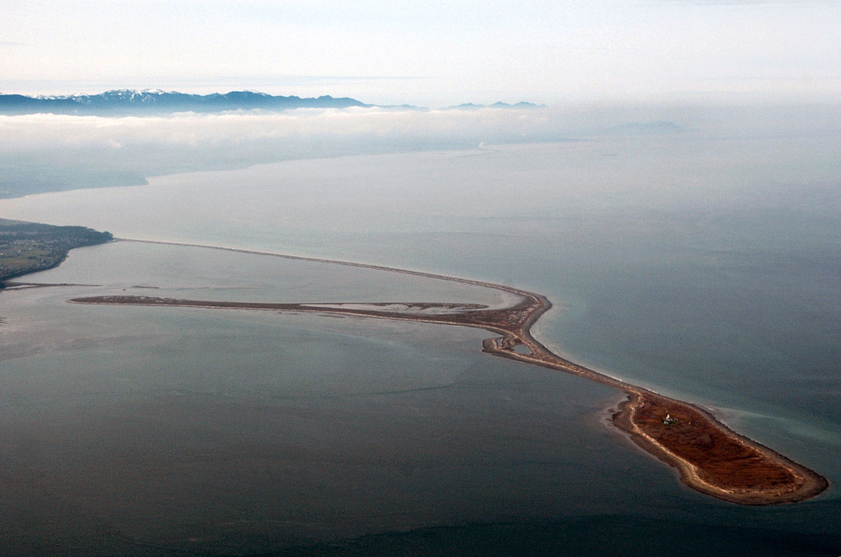
The prevailing waves can change direction at times, and so a secondary spit has formed within the coastal side of the Dungeness Spit. It's called the Graveyard Spit, and it can be seen clearly in the Wikipedia picture below. It is fed by sand coming around the end of the Dungeness Spit.
It's not hard to get to the spit. There is a campground and a parking area for the Dungeness National Wildlife Refuge (the enclosed bay is a protected area; more than 200 bird species are known from the area). From the parking lot a half-mile long paved trail wanders through the forest to an overlook where I got most of the pictures seen above. From there you can walk down to the beach and walk as far as you wish out onto the spit. If you are ambitious enough, you can get to the lighthouse for a tour. It dates from 1857 and is the second oldest lighthouse in the state. It is staffed today by volunteers.
It's not hard to get to the spit. There is a campground and a parking area for the Dungeness National Wildlife Refuge (the enclosed bay is a protected area; more than 200 bird species are known from the area). From the parking lot a half-mile long paved trail wanders through the forest to an overlook where I got most of the pictures seen above. From there you can walk down to the beach and walk as far as you wish out onto the spit. If you are ambitious enough, you can get to the lighthouse for a tour. It dates from 1857 and is the second oldest lighthouse in the state. It is staffed today by volunteers.
 |
| Source: Wikipedia |
This post is part of a new series about our recent field studies course to British Columbia and Washington. Next stop: Olympic National Park!
1 comment:
Such an excellent story teller! You always give me mental adventures 🙂🤗
Post a Comment