Wednesday, April 6, 2022

Red Hills Area of Critical Environmental Concern (Couldn't the Bureaucrats Just Call it a Preserve?): Spring Update

Welcome to one of the most unique ecosystems and habitats in California's wealth of incredible places. It was ignored initially by miners in the region because it had no gold (the Mother Lode is a scant two miles away).  It was more recently ignored because it had no grass for grazing and poor soils incapable of growing anything "useful". The Bureau of Land Management, tasked in its early days of giving away land by way of the Homestead Act couldn't give the free acreage away at all. All but ignored by federal government, the absentee owner, it became an unofficial garbage dump, unauthorized shooting range, and unsanctioned off-road vehicle route. 
Why were the soils so poor in nutrients and toxic to plant growth? It was the underlying rocks: the serpentine and other ultramafic rocks associated with the Melones Fault in the Sierra Nevada Mother Lode. The soils developed on these rocks were severely deficient in important macronutrients, and contaminated (so-to-speak) by toxic metals. Most plants, including most grasses, cannot survive in these soils. Some select species tolerate the soils, and a few rare ones thrive. It is literally a different world, and as you can see in the picture above, the change is abrupt, as the prairie grasses and oak woodland suddenly give way to ceanothus or buckbrush and gray pine.
By the late 1980s the Bureau of Land Management, the federal agency in charge of the Red Hills area, belatedly recognized (with the encouragement and assistance of community and environmental activists) the unique nature of the ecosystem here, and declared it an "Area of Critical Environmental Concern", the kind of a designation that only a bureaucrat could love. It turned out that this landscape contained a large variety of endemic species found almost nowhere else, including a unique fish species, the Red Hills Roach (Lavinia symmetricus). Clean-ups were organized, and minimal tourists facilities (trails, parking areas, vault toilets, and a nature trail) were constructed. 
Bitter root (Lewisia rediviva)
For much of the year, especially in the hot dry summer, there is little to recommend about the Red Hills. Most of the plants are dead and gone to seed. But for a few months during the cooler wetter spring season, the hills come alive. It turned out that many of the plants adapted to living in these soils produce a vivid display of color when they bloom.
California Goldfields (Lasthenia californica) and scattered poppies
We took a bit longer to make our way up to the Red Hills this year, in large part because there hasn't been more than a spatter of rain since December. We are in the midst of another year of lingering drought. But in the end we decided to have a look, and although it came nowhere near the pyrotechnics of color of past years, there was more than enough to make for a satisfying excursion.
Poppy, a flower that seems able to grow in just about any environment California can fling at it.
Enjoy a little bit of color!
Monkeyflower (Erythranthe sp.)

Blue Dicks (Brodiaea)

The parking area and trailhead at Red Hills ACEC

Poppy sp. and Blue Dick (Brodiaea)

Serpentine
The Red Hills got their name from the red soils that develop on the ultramafic rocks, including serpentine. The rocks are rich in iron, thus the red color, but fresh surfaces of the rocks are generally shades of green, as can be seen above.
Paintbrush sp.

Lupine sp.

Lupine sp.
The Red Hills Area of Critical Environmental Concern is in the Sierra Nevada foothills near Chinese Camp off of Highway 120. If you want to learn more, or pay a visit, information about the Red Hills can be found on this BLM website, and the trail and road map can be found here.
 

Thursday, March 31, 2022

Those Things We Scientists Never Talk About...

I am often asked if I have run across strange phenomena in my travels. My journeys take me to many different places and environments, and frankly, some really...um...eerie things have been known to happen. It is not one of those things that we earth scientists like to talk about, and one might be tempted to say, really that we could say, we have been hiding this knowledge from the public for years. I don't think that conspiracy is the right word here, it's just that we don't think that the public at large should be led to believe in the existence of these things.  That there are things out there...
They're seen in caves in and around Mt. Shasta and Medicine Lake Highland. If you are in the dark long enough...you start to see the lights. They float through the open spaces of the lava tubes, the long passageways produced when subsurface lava flows drain away from openings downslope. They aren't easy to photograph, but I once hid behind a pile of broken rubble and left the shutter open. The spectral lights appeared around the corner and silently passed by.
There are stories about the Atlanteans and Lemurians inhabiting the underworld of Mt. Shasta, and incredibly detailed descriptions of how they carved the tunnels of their underground cities. Being the hard-boiled logical scientist I am, I am not unreluctant to declare that this is the only possible explanation for these lights. The underground civilizations of beings who lost their islands in the Mediterranean Sea and Indian Ocean tens of thousands of years ago in giant cataclysms and who came to Mt. Shasta and Medicine Lake Highland to some might make so much more sense than anything else that could explain the images on my digital camera.

In Avril Erste, there is a colleague who can back me up on all my assertions. Avril has seen these same lights in other caves, too, much farther south than Mt. Shasta. They're in the caves of the Sierra foothills too...
I want to believe...

Friday, March 25, 2022

A Tale of Two Pullouts: Yosemite Valley From a Different Angle

El Capitan and the Merced River from the east

I know that I am truly privileged living as I do only a two-hour drive from one of the most sublime places on Earth, Yosemite Valley and the Sierra Nevada. We head up there two or three times a year, sometimes with students in tow, and sometimes on our own, so in 30+ years we've been there at least 100 times.

And I never get tired of it.

Part of the allure is seeing the seasonal changes. Winter provides the coating of snow, while fall provides the changing colors of foliage. Spring offers surging waterfalls and wild river flows. Summer provides...well...crowds, but also nice moments in places we learn of where the crowds can be avoided. We have favorite meadows and lakes for instance where people rarely stop. No matter when or where we visit, there always seems to be something new or different.

The Cathedral Spires are tucked away on the east side of the Cathedral Rocks at Bridalveil Falls
I know how it is if one gets to see Yosemite Valley for the first, and maybe only time. I've had that experience at so many other places around the world. The time available may be very limited, one may be part of a tightly controlled tour, and no one wants to miss any of the most famous views or hikes. And so it is that there is the required stop at Tunnel View, Bridalveil Falls, Cook's Meadow for the view of Yosemite Falls, and maybe Ahwahnee Meadow for a view of Half Dome. The walk to Lower Yosemite Falls, or Nevada Falls. And the Visitor Center. It makes for a full day, and a fulfilling day too. One of the most spectacular days you might ever experience.

And I never get tired of it. I'm perfectly happy to hit those same spots on my 101st trip to the valley. The season, the time of day, and the weather all conspire to make each stop a unique experience of wonder. But sometimes there are changes of a different nature, and that makes some trips really memorable. That is what today's collection of views is about.
Sentinel Rock rises above the south side of Yosemite Valley across from Yosemite Falls
Since the time that Yosemite Valley became a park, suppression of all forest fires has been the official policy. It was not however the natural condition of the parkland, nor was it the normal condition of the valley floor over the last few thousand years when it was managed by the original inhabitants of the region. 

The Ahwahnechee people, with roots among the Miwok and Paiute peoples of both sides of the Sierra, depended in large part on the acorns of the Black Oak and grazing animals like deer or bighorn in Yosemite Valley. It was in their best interest over the centuries to allow fires to burn through the valley floor and hold the quick-growing conifers at bay. When the park administrators put an end to the fires, the pine and cedar trees choked out meadows (only 65 acres of the original 750 acres of meadows remain) and grew into impenetrable thickets, blocking views of the canyon walls above.

What's worse is that choking off small fires can cause a buildup of fuel in the forest that could only lead to much worse fires than usual. This was always a danger, but it is far more hazardous today in a time of warming climate and extended droughts. Every Californian is fully aware of how wildfires in the state have morphed into monstrous events without parallel in written history.

The National Park Service has come around in their fire philosophy, especially after extensive fires a few decades ago in Yellowstone and Mesa Verde National Parks. They have instituted new policies of prescribed fires and selective tree removal to make the parks safer, but also to enhance the experiences of park visitors. In what way? The views.
The distinctive profile of the Three Brothers is the result of parallel jointing, or fractures in the granite that occur as the rocks are exposed by erosion
There are the parking lots that attract the majority of park visitors, but on the roads that loop around the valley there are many small pullouts, enough for perhaps three or four cars. In years past there seemed no real purpose for them, as they were surrounded by thick forest and offered no views or trailheads. On our visit a week ago, I found that two of those previously uninteresting pullouts had had the forest thinned out, and that they now possessed some outrageously spectacular views! The familiar iconic cliffs were there, but from angles I had never really seen before. In particular there was the long vertical cliff extending east from El Capitan, a view of the rarely seen Cathedral Spires (as opposed to the Cathedral Rocks at Bridalveil Falls), the vertical pillar of Sentinel Rock (often missed by people staring at Yosemite Falls), and the Three Brothers, which have never really had a designated viewpoint and are usually hidden by the tall trees. Upper Yosemite Fall was visible as well, perhaps farther away, but how many of you Yosemite veterans can recall seeing the falls with not a single other person in sight?
Yosemite Falls from a pullout west of Swinging Bridge
We had a leisurely lunch at the pullouts and wandered about taking pictures, and only two or three cars pulled off the road, and no one else actually got out. Except for the noise of passing traffic on a crowded Sunday afternoon, we literally had the best of Yosemite Valley to ourselves.
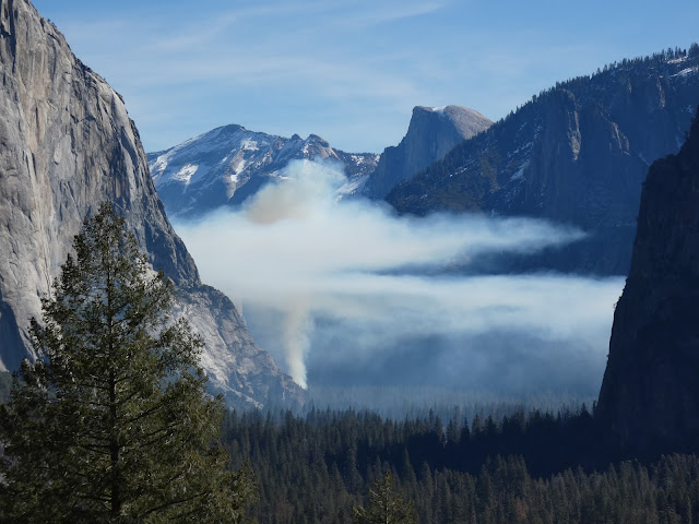
Prescribed fire in Yosemite Valley, with Half Dome and Clouds Rest in the distance.
We stayed at the park through Monday morning, and when we stopped by Tunnel View we witnessed another chapter in the new fire/forest regime: the ignition of a prescribed fire. It was done in March because the ground was still damp enough to prevent the uncontrolled spread of the fire. If you are on Facebook and would like to know more about forest management in Yosemite, check out (1) Yosemite Fire and Aviation | Facebook.


Monday, March 14, 2022

The Merced River of California: A Place for Wildflowers and Landslides (and Yosemite Valley)

The Merced River is one of California's extraordinary waterways. First and foremost, it is the river that carved Yosemite Valley, which is one of the world's most spectacular valleys. You may be forgiven for thinking that glaciers carved Yosemite Valley, and they certainly had an important role, but it was learned years ago that the heavy-duty work of carving the 3,000-foot-deep gorge was done before the ice ages ever arrived 2 million years ago. The glaciers certainly modified the shape of the valley, but the depth was first achieved by water flowing over stone.

We spent a couple of days in the valley at a time when the crowds are few, the snow is in retreat, but the green of spring is still some weeks away. It was neither winter nor spring, but the waterfalls were full and the birds were becoming more active, and we had a marvelous time. This morning brought a sight we had never seen in dozens of previous visits though: the beginning of a controlled burn. 

The native Americans who first lived and hunted in the valley knew the value of fire. They would regularly set fires to the forest and meadows to clear out undergrowth and maintain the extensive meadows on the valley floor. When the park was established in 1890, fire became the enemy and any hint of a fire was quickly put out. As a consequence the meadows shrank from the original 750 acres to less than 100 today. The forest became choked with young trees, and fuel built up on the forest floor. It was a major disaster-in-waiting. In recent years, the park management has sought to return the valley floor to something resembling the environment that existed prior to European colonization. Some of the activity has involved some controversial logging operations, and the controlled burns can interfere with the experience of visitors, but the eventual changes will be a vast improvement over present conditions.
One of our real motivations for the trip actually involved a different part of the Merced River, the deep canyon downstream of Yosemite Valley. The Merced River canyon downstream of the lowest extent of the glaciers is a different place entirely. The vertical walls of glacially-shaped granite give way to a V-shaped river valley covered by vegetation that often obscures an extensive belt of metamorphic rocks that are hundreds of millions years older than the granite intrusions.
While not as "spectacular" as Yosemite Valley, the canyon is not without scenic wonders. Indeed, for a few weeks in the spring the walls of the canyon can explode into a color palette that puts the gray granite cliffs of Yosemite Valley to shame. Wildflowers like golden poppy, lupine, and fiddleneck and many others can cover the slopes from the river to the canyon rim.
The climax (if it comes; it's been a dry year) lies a few weeks in the future. But here and there, the slopes provided a hint of what is to come.
The redbuds are just getting started with their not-red buds. More of a pink/purple shade if you ask me.
The slopes of the gorge are also an environment adapted to fire. In the Mediterranean climate the winters are cool and wet, and the summers are very hot and dry. Fires have always swept through the gorge, but those of recent years have been particularly intense due to the extended droughts and higher temperatures due to global warming.
Ultimately fires are a necessary part of the environment, but they can seem particularly tragic in the short-term, especially when people are killed or developments destroyed. The wildflowers play an important role in the recovery of the slopes, as they are pioneer species that help rebuild nutrients in the soils that can assist in the return of the shrublands and forest. The seed may lie in the soil for years before conditions are right for germination, and then the barren slopes come alive with color.
The Golden Poppy is a particularly visible part of the wildflower population. It is California's state flower, and it was a great choice because it thrives in many if not most of California's diverse ecosystems. They're common in the Coast Ranges, the Great Valley, the Sierra Nevada foothills, the volcanic landscapes of the Cascades and Modoc Plateau, the mountains of southern California, and in the Mojave Desert (the Antelope Valley Poppy Reserve is spectacular right now, from what I am hearing). They can also grow on California's strange serpentine soils that most plants cannot tolerate.
A final sight were looking for was the Ferguson Slide. The slope at this particular turn in the river was always unstable, but in 2006 the entire slope slide downwards and covered the highway with tens of thousands of cubic yards of boulders. Far more debris remains on the slopes above, and for a time there were fears that a truly massive slide could block the river and form a natural dam with a lake several miles long. A number of "fixes" were considered, and in the meantime "temporary" bridges were built to provide one-way access on the busy highway. Temporary in the sense that they have been there for fifteen years and counting.
In the end they have decided to build an "avalanche shed", but for rocks instead of snow. The cost is in excess of $180 million (which at the time was about the entire budget for Yosemite National Park). Nature doesn't take kindly to attempts at altering the physics of the slope, and some of the first attempts at stabilizing the upper slopes were laughably sloughed off. There was an earlier coating of the fencing material that was destroyed soon after application. They spent several years carting off nearly 150,000 cubic yards of metamorphic rock and have again tried to fence in the slope. It will be interesting to see what happens when the construction of the shed actually begins.
The photo above is the most comprehensive picture I've been able to capture. I made sure to be last in line when the traffic light changed and allowed the line of cars to follow the one-lane road. I lingered a few seconds to get the shot, and hurried along to make sure I didn't run into oncoming traffic on the narrow bridge. 

There are many more stories to tell of the Merced River downstream, where it flows through the Mother Lode, the places where it lies trapped in the waters of Lake McClure and Lake McSwain, the dredge pits at Merced Falls, and the slow journey across the floor of the Great Valley where it ends in the San Joaquin River. Those will come another day!

Saturday, February 5, 2022

Winter Days at the National Wildlife Refuges of the Great Valley, and Remembering What Once Was

What's the largest number of birds you've ever seen from one spot?

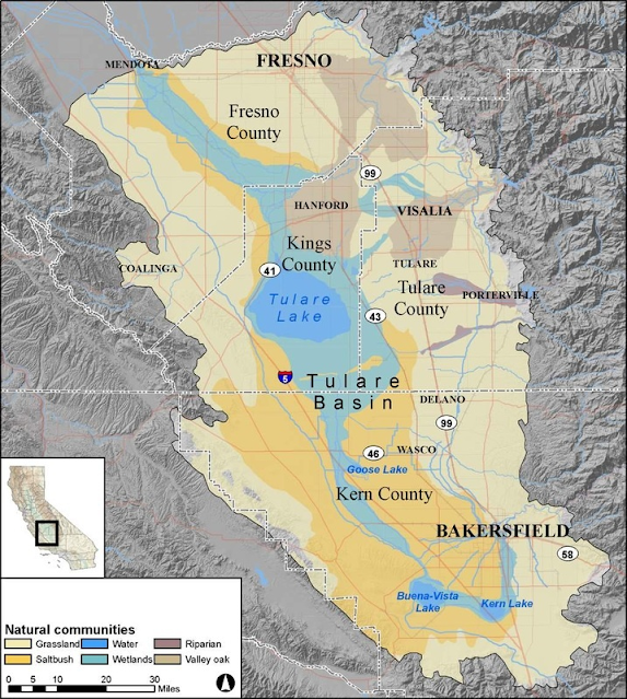
The Great Valley of California is a great place to see a lot of birds in one place. In pre-colonist days, the 400-mile-long valley was a prairie that was watered by a series of rivers flowing from the adjacent Sierra Nevada. There was enough water that even in historical time there were two immense lakes between Bakersfield and Fresno, Tulare Lake and Buena Vista Lake. Before water diversions for irrigation caused it to dry up, Tulare Lake was the largest freshwater lake west of the Mississippi.
Source: Quora
The mild winter climate of California led to the adoption of the wetlands and marshes of the Great Valley as the favored seasonal home of millions upon millions of waterfowl and other migratory birds of the arctic and far north. I can hardly begin to imagine what a wintertime journey through the pre-European Great Valley must have been like.
The ecological role of grazer in the refuges is occupied by a handful of deer and lots of sheep and cows to make up for the now-extinct megafauna

But historical accounts and paleontology can provide us some idea. In addition to birds, the vast prairies supported huge herds of tule elk, deer, antelope, and even bison. Prior to 12,000 years ago, the plant-consuming animals included giant ground sloths, mammoths, mastodons, horses, and camels. The birds and grazing animals were the prey of an imposing array of predators including the recently departed California Grizzly Bear, black bears, wolves, mountain lions, coyotes, and foxes. The pre-12,000-year crew included saber-toothed cats, dire wolves (bigger than wolves of today), American Lions, jaguars, and the immense Short-faced Bear, an animal that would have made a Grizzly think twice about a confrontation. The reason for the almost simultaneous extinctions of the species of the so-called 'mega-fauna' is a subject of contention among geologists, paleontologists and anthropologists (the role of humans has not been ruled out).
This cuddly little Short-faced Bear can be seen at the Fossil Discovery Center near Madera
I was thinking about this as we made our customary winter journeys to the local national wildlife refuges in and around Modesto and Merced. The main units open to visitation include the Merced, the San Luis (including the separate Bear Creek Unit), and the San Joaquin River National Wildlife Refuges. Although the boundaries of these refuges tend to be very square or rectangular and they are crisscrossed by maintenance roads, they are the only places that come close to recreating the primeval landscape that once existed.
The national wildlife refuge system grew out of a number of motives, some noble, others not so much. When wetlands of the valley were drained and planted with crops, millions of birds found their ancestral winter homes gone. With nowhere else to go, many of the geese and others began to forage on the tilled fields to the distress of the farmers. Instead of massacring untold numbers of birds, a series of refuges were established up and down the valley to provide a haven and food for at least some of the migrants. Of course, the refuges were also designed to preserve populations of the birds so they could be shot. Much of the refuge funding comes from the sales of hunting permits.

Snow Geese at the San Luis National Wildlife Refuge

So that is where are today. The refuges provide forage for millions of migratory cranes, geese, swans and ducks (in many they grow fields of corn for the singular purpose of feeding the birds). The birds are too crowded, and diseases can spread if the flocks are not managed properly, but it is a better situation than having no refuges at all. Some species, especially the Aleutian Cackling Goose, have been brought back from the brink of extinction (once down to just 300 or so birds, the population is more than 100,000; they mostly shelter at the San Joaquin NWR just west of Modesto). And yearly, more and more abandoned farmlands are being converted to the original riparian habitat to allow for population growth. 

I don't do video often, but the one at the top seemed necessary because I was looking at what I believed was the largest single grouping of birds I've ever seen (and I've been exploring these refuges for 7-8 years now). It required about a 180-degree pan. On the other hand, there is nothing in the world quite like watching thousands of geese taking flight all at once. When we were at the San Luis NWR last week, the serene view was of several thousand Snow Geese and Tundra Swans. It's not really a good thing for the birds to be scared into the air, as it uses precious energy, and they could get hurt. But a helicopter flew overhead at a low elevation, and it spooked the geese (the swans seemed like they could care less) and several thousand took flight. I caught the flight on video, and you can clearly hear the helicopter. I took a picture of the craft thinking to report it, but it turned out to be medi-flight out on an emergency call.  

The number of birds and the variety of birds at the local refuges is truly astounding. We saw 50 species at the San Luis Refuge last week and 46 at the Merced Refuge yesterday. The really good birders will report 60-65 in a single trip. And the birds are beautiful. Here are some that caught my eye this last week.
This Great Egret was at the San Luis NWR. Both refuges offer "auto-tours" where visitors stay in their cars (kind of like those African savannah tours, but there aren't any lions trying to eat you). The cars serve as blinds, startling birds far less than humans bumbling around.
We were looking for swans and saw large white birds off in the distance. They turned out to be American White Pelicans. They may be the most ungainly-looking birds on the ground but are positively graceful in flight. And they are huge.
The blue bill of the Ruddy Duck is rather distinctive.
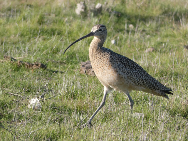
The prize for wildest beak goes to the Long-billed Curlew. I guess they can reach bugs and worms in the mud and soil that other birds can only dream of.
The Greater White-fronted Goose may be one of the more unfamiliar goose species around the valley. I've seen only a few in urban settings. Like the others, they are long-range migrants.
One of the special treats for the last two or three years has been a female Vermilion Flycatcher that decided to spend winters at the Merced NWR. This is the extreme north end of their range, and only a few are ever seen on a yearly basis in Stanislaus or Merced counties. Global warming may be allowing them to expand northward, and it may be only a matter of time before the scattered males and females find each other and start making little flycatchers.
This is an American Avocet, another bird that has a crazy bill that is good for probing deep in the mud.
There are a goodly number of raptor species that live in the refuges. One of the most beautiful is the White-tailed Kite. We thought we were done with photo opportunities when we reached the open grasslands at the end of the auto-tour at Merced, but this kite was perched on the sole tree eyeing the ground squirrels (and they were eyeing it).
The last bird of the day was the biggest surprise of all because it was the first time I had seen it in several years. It's a Black-bellied Plover, and it's not all that rare. It's just that I don't always know to look for it or recognize it when I see it. And it doesn't have a black belly. The males grow it when breeding season comes along.
Sunset at the Merced NWR
We here in the Great Valley sometimes forget that it is indeed a great valley, and that there are treasures that lie just beyond the boundaries of our cities. The auto-tours at Merced and San Luis provide opportunities for all, but those who want to walk will find a number of nice level trails. I especially recommend the Pelican Trail at the San Joaquin River National Wildlife Refuge. It passes through a series of diverse habitats and offers the greatest diversity of birds outside of the Modesto Water Treatment Plant (seriously, sewage ponds attract a lot of birds!). Check it out sometime, or any of the others up and down the valley.