Tuesday, January 1, 2019

Good-bye to 2018: 12 Months of the Joy of Geology


Mesa Arch in Canyonlands National Park
It's been a year. There are lots of ways of looking at the events of 2018 and so many of them are tragic and unjust. But there is always hope as well. There are still the beautiful places of the Earth, and always a chance to seek them out, no matter where you are. That's the joy of being a geologist and a teacher. Or being anyone with a curiosity about our planet. What follows are twelve months of exploring our planet from my base in California's Great Valley.
Merced National Wildlife Refuge, south of the city of Merced.
Where does one go in January? So much of the countryside is covered in snow, but California is kind of special in that regard. We get to visit the snow if we want and then we can go home to our valleys and coastlines. The migrant birds know all about this. Millions of geese and other species spend their summers in the Arctic, but when the snows come they fly south and spend the winter in a series of wetlands and prairies that have been preserved in places like the Great Valley. Our destination in January was the Merced National Wildlife Refuge. There were thousands of Sandhill Cranes, Snow Geese, Ross's Geese, and multitudes of ducks. It is an overwhelming experience to stand at the edge of the wetlands and imagine this valley hundreds of years ago before agricultural development took over 95% of the landscape.
Zabriskie Point and Manly Beacon in Death Valley National Park
The most satisfying aspect of a teaching position in geology is the chance I have to share the incredible planet with my students in my classroom of course, but also in the field. In February our intrepid crew headed out to Death Valley National Park in the Basin and Range Province of eastern California. The valley is a vast fault graben with 11,000 foot peaks next to valley floors below sea level. It is the hottest place in the world and the driest place in North America, yet 20,000 years ago it contained a 100-mile long freshwater lake and grassy savannas with horses, camels, and mammoths. Some of the fish who inhabited the lake still survive today in isolated spring-fed ponds.
Natural Bridge in Death Valley National Park
Death Valley is recognized as the premier geology park in the national park system, containing rocks as old as 1.7 billion years, and including layers and intrusions from every period in Earth history ever since.

We survived a phenomenal windstorm on the last night of our trip. I hate to say I littered in a national park, but somewhere out on the dunes there is a tarp that blew away from under my tent in the night.
The Ghirardelli Store in Hornitos within the Sierra Nevada Mother Lode
Our field studies in March were closer to home. We journeyed through the southern Mother Lode of the Sierra Nevada. We saw ghost towns, old mines, and the quartz veins that were the source of the ores of the California Gold Rush in 1848. The ruins in the picture above are the Ghirardelli Store in Hornitos. Before he made chocolate in San Francisco, the man sold supplies to the miners in the Mother Lode.
Yosemite Falls in Yosemite Valley
In April, Yosemite National Park took center stage, as we took two field studies trips there. One of them was the morning after an epic flood that closed the park for a day or two. When we got there, the Merced River was still at flood stage and the waterfalls were booming.
Mt. Rainier in Washington
In May, family matters found us on a plane out of Seattle, Washington. We left for home in the early evening while Mt. Rainier was capturing the last rays of the sun. As you may have read in the last post, Rainier (14,411 feet) is the tallest volcano in the Cascade Range, and has more glacial ice than any mountain in the Pacific Northwest. The potential of eruptions happening under the ice makes Rainier one of the most dangerous volcanoes on the planet. Lahars (volcanic mudflows) could overwhelm some of the cities of the Puget Sound.
Horseshoe Bend on the Colorado downstream of Lake Powell and Glen Canyon Dam
One of the greatest adventures one could ever experience is an in-depth exploration of the Colorado Plateau. It is a showcase of geology with a treasure trove of national parks and monuments. In June, our intrepid crew headed out to plateau country where we explored Grand Canyon, Zion, Bryce Canyon, Black Canyon of the Gunnison, Mesa Verde, Arches, Canyonlands, Capitol Reef and Great Basin National Parks. The region is so extraordinary that a place like Horseshoe Bend on the Colorado River isn't even in a national park or monument.
House on Fire Ruin in Bear's Ears National Monument
One of the great crimes of the present administration in Washington D.C. was the attack upon the Bear's Ears National Monument. Even though the law didn't allow it, the park was reduced in size to 15% of what it had been before. And for the sole purpose of money, i.e. oil drilling and uranium mining. I hope the courts do the right thing this year.
Hurricane Ridge in Olympic National Park
In July Mrs. Geotripper and I escaped the heat and dust of the Great Valley and headed north along the coast, eventually reaching Olympic National Park in Washington. Hurricane Ridge is one of the most stunning viewpoints in America. The views take in the alpine peaks glaciers of Mt. Olympus, the temperate rainforests of the valleys, and the coastlines around Port Angeles. The mountains are composed of oceanic sediments and seafloor crust pushed upwards by the motions of the Cascadia Subduction Zone.
We stayed close to home in August, but almost every morning found me walking the Parkway Trail along the Tuolumne River where it flows from the Sierra Nevada foothills onto the floor of the Great Valley. Birders (including me) discovered 115 species on this trail over the course of the year.
Valentine Cave in Lava Beds National Monument
The resumption of classes in August and September found me and my students on the road again. We explored the Cascades Volcanoes, including Mt. Shasta, Lassen Peak, Medicine Lake Highland and Lava Beds National Monument. Lava Beds has miles of lava tubes, one of the greatest concentrations in the world.
In October we went underground again with an exploration of Black Chasm Cavern. The cave has been carefully managed so that visitors can see cave decorations that are absolutely pristine. The cave has thousands of fragile speleothems called helictites. I call them stalactites on acid...
November was the lost month. The horrific fire in Paradise caused air quality to suffer throughout the state and the school shut down for a week and a half. It's the first time this has happened, and our scheduled field trip to Pinnacles National Park was postponed to the beginning of December. We went underground again, in yet another kind of cave. It wasn't limestone or marble, and it was a lava tube even though the Pinnacles are volcanic. It's a talus cave, one caused by giant boulders falling into and covering a narrow canyon. Hikers are in near total darkness for upwards of a quarter mile.

December arrived and along with it came the holidays. We have family all along the coast from California to Washington, so Christmas for us was a very long road trip. On our last night we stayed near Mt. Shasta in Northern California. The sunset provided beautiful lenticular clouds around the summit of the second and third highest volcanoes in the Cascades (you'll have to check out the last post to learn about that one).

And that was the story of my year and that of my students and Mrs. Geotripper. We saw a lot of incredible things, and my whole purpose in describing these places is to encourage you to explore them for yourselves. I know that this is impossible for many, which is quite literally why I write this blog. But if you can make time and get away, seek out the wild places where you live. If your local college offers field studies courses, consider getting back into school for some personal enrichment. I guarantee you won't regret it.

If you live in the vicinity of Modesto, the Modesto Junior College Geology Department will be offering a great line-up of field studies courses. We'll explore Death Valley again in February, the Southern Mother Lode in March, and Yosemite Valley in April. In September we'll head out to the Eastern Sierra Nevada and Owens Valley. In October we'll travel through the Mother Lode, and in November we'll be back to Pinnacles National Park.

But our premier trip with be on June 26-July 10 when we head to British Columbia and the Pacific Northwest. We'll be exploring Olympic and North Cascades National Parks, Vancouver Island, and the Coastal Mountain Ranges around Whistler and Pemberton. It will be a memorable experience. If you are interested, keep an eye on this blog, follow our Facebook page at https://www.facebook.com/groups/1920712791360611/, or the class web page (soon to be updated) at http://hayesg.faculty.mjc.edu/GeologyPacificNorthwest.html.

See you on the road!

Monday, December 31, 2018

Can You Name the Third Highest Cascade Volcano?


Can you name the second highest? How about the highest?

It's probably not a fair question for most of you. I've always had a mind for the elevations of mountains, having memorized them effortlessly throughout my life, ever since I learned of the existence of topographic maps. I've even been irritated at the advent of the GPS system because they recalibrated the official heights of many of the iconic mountains of my youth. It's confusing.

But anyway, about those Cascades...

The Cascade Range extends from the Lassen Volcanic Complex in Northern California to Mt. Garibaldi in the southern part of British Columbia. The chain of active volcanoes is the result of the subduction of the Pacific Ocean crust beneath the North American continent. Portions of the oceanic crust melt and rise towards the surface. Once in awhile one or the other volcanoes erupts as did Mt. St. Helens in 1980 and 2004, and Lassen Peak in 1914-17. Others are less active, but they are close enough to population centers to constitute a serious hazard.
The highest volcano in the chain is Mt. Rainier in Washington at 14,411 feet (4,392 meters). It was actually much higher, perhaps 16,000 feet, but debris avalanches and glacial erosion have torn away the older summit. The mountain has more glacial ice than any other mountain in the lower 48 states, and an eruption combined with melting ice would present a huge threat to the urban areas in the southern Puget Sound.

Mt. Shasta (14,162 feet; 4,317 meters) is the second highest Cascades volcano, and the most voluminous stratovolcano in the chain (two basaltic shields, Medicine Lake Highlands and Newberry Crater have an even greater volume). It has erupted roughly every 600 years with the last eruption about 200 years ago.

Now this is where things get sticky. The third highest peak in the Cascade Range is normally taken as Mt. Adams in Washington at 12,280 feet (3,740 meters). But it all depends on how you define "mountain" or "volcano". Geographers often consider a hill to be a mountain if it has a prominence of 400 feet or so. By that measure, a subsidiary peak on the summit of Rainier, Liberty Cap (14,112 feet; 4301 meters) is the third highest peak in the Cascades, but it isn't a separate volcano. That honor goes to the volcano in all of these pictures that I took over the last two days while traveling home through Northern California. It's the peak that never gets enough respect. Even the name is diminutive: Shastina.
Shastina rises to a height of 12,355 feet (3,760 meters), and has a prominence of 450 feet from the main cone of Shasta. It formed in a series of eruptions about 9,800 years ago.

Clouds covered the main summit of Shasta this weekend, so Shastina stood out as a separate and unique peak as we drove south. On other trips, it doesn't dominate the skyline in quite the same way, but it is still a huge mountain. It's the flattened peak on the right side of Shasta in the picture below. In you mind's eye, you could erase the main summit and still see an awesome volcano.

Friday, December 28, 2018

No, It's Not Erupting...and Probably Won't Any Time Soon: Mt. McLoughlin in the Oregon Cascades


There is a grand and momentary sight to be had if you are driving south on Interstate 5 about seven or eight miles north of Medford, Oregon. If the weather is clear when you round the last bend before the Rogue Valley, a beautifully symmetrical volcano comes into view. It is called Mt. McLoughlin. It's really quite dangerous for geologists to drive on this highway because of our tendency to swerve and hit the brakes the moment we see the volcano and start scrabbling around trying to find the camera. I get honked at a lot by angry truckdrivers all the time around that moment.

Luckily for me, Mrs. Geotripper was riding shotgun today, and I knew the corner was coming up. She got the camera ready ahead of time and was able to snap a couple of pictures. With the news of volcanoes erupting around the world at the moment (check out Mt. Etna in Italy and Krakatoa in Indonesia, for instance), it's not surprising to consider for a moment that McLoughlin looks like it's erupting. What we are seeing here is clouds forming as warmer air masses are blown upslope into colder air around the summit. The cooler temperatures cause the humidity to jump and condensation forms the clouds around the volcano summit. Sometimes the clouds are more lens-shaped (lenticular), giving rise to legends of UFO landings and aliens.

Mt. McLoughlin is 9,495 feet (2894 meters) in elevation and can best be described as a composite cone, as it is in part a basaltic shield with a prominent summit cinder cone and andesite flows. It has not erupted in the last 20,000-30.000 years and thus appears to be low on the list of recognized hazardous volcanoes. From some angles McLoughlin is a deceptively symmetrical cone. The summit has been deeply carved by glaciers.

Mt. McLoughlin is soon lost among the trees, buildings, and powerlines of Medford. It's not a particularly worrisome volcano although it is capable of wreaking havoc if the unlikely ever happens. But if you keep driving south on I-5, there are highway signs pointing to a volcano, or more correctly, a caldera, that is not visible at all from the freeway. It's Crater Lake, and it is a much more dangerous volcanic complex than McLoughlin. It erupted catastrophically only 7,000 years ago. And farther south still is Mt. Shasta. It looms menacingly over Northern California, and we'll have a short look at it in our next post.

POSTSCRIPT: I found out I had some aerial shots of McLoughlin from a flight I took in 2005. Here's one of the best. We were east of the volcano looking west. The glacial cirques are clearly visible...

Wednesday, December 26, 2018

Colorful Gifts of the Earth: the Butterflies


If there were a single thing about our planet that I could guess that the deities made for pure visual pleasure, it would be the butterflies. I'm not aware that they are an environmental scourge anywhere (I'm kind of disregarding their caterpillar stage of life here), and they come in such a stunning variety of colors and patterns. I'm pretty sure that if they ever thought of such things, they would probably disagree with my assessment, since their lives are filled with the necessity of reproducing and all.
We've been pretty hard on butterflies. The prevalence of pesticides in my region has thinned their ranks to the extent that I rarely see them despite spending a lot of time outdoors. The famous migrating Monarchs have suffered a population crash in recent years, in part due to habitat destruction and climate disruptions.
In any case, I was at the Pacific Science Center in Seattle Washington today and was quite entranced with the butterfly enclosure. Out came the camera, and I offer you this gift of color on the day after Christmas. May you have a new year of peace and justice.
I will try to provide some identification of these species when I get a chance...


Saturday, December 15, 2018

How to Make a Rock Garden: Update on the Great Valley Outdoor Nature Lab


How to make a rock garden:

First, you have to find rock seeds. Try for variety, a mixture of igneous and metamorphic, maybe some sedimentary. Local rivers are good places to look. They're even shaped a little bit like eggs.
Then you have find a good place for your rock garden. Any vacant lot has potential, but some are better than others. I picked this one because it is right next to the Great Valley Museum at Modesto Junior College. If we can get a good rock garden going, it can enhance the mission of the museum and college by providing a microcosm of the geologic environment of our region.

Then you plant the rocks...after a few weeks you might notice that the ground is starting to ripple and develop bumps and hummocks. This is a natural progression as the rocks start to grow. But something is missing...
Ah! Water. For the rock garden to truly thrive, try adding lots of water. That will really get those rocks sprouting. And now we wait.

And we wait. You can even walk around the hummocks to see if any of the rocks are peeking though yet. But don't cheat and try to dig them out ahead of time. They might stop growing entirely.
Then comes that magic day when you arrive at work and find that the rocks have sprouted! They're huge!!
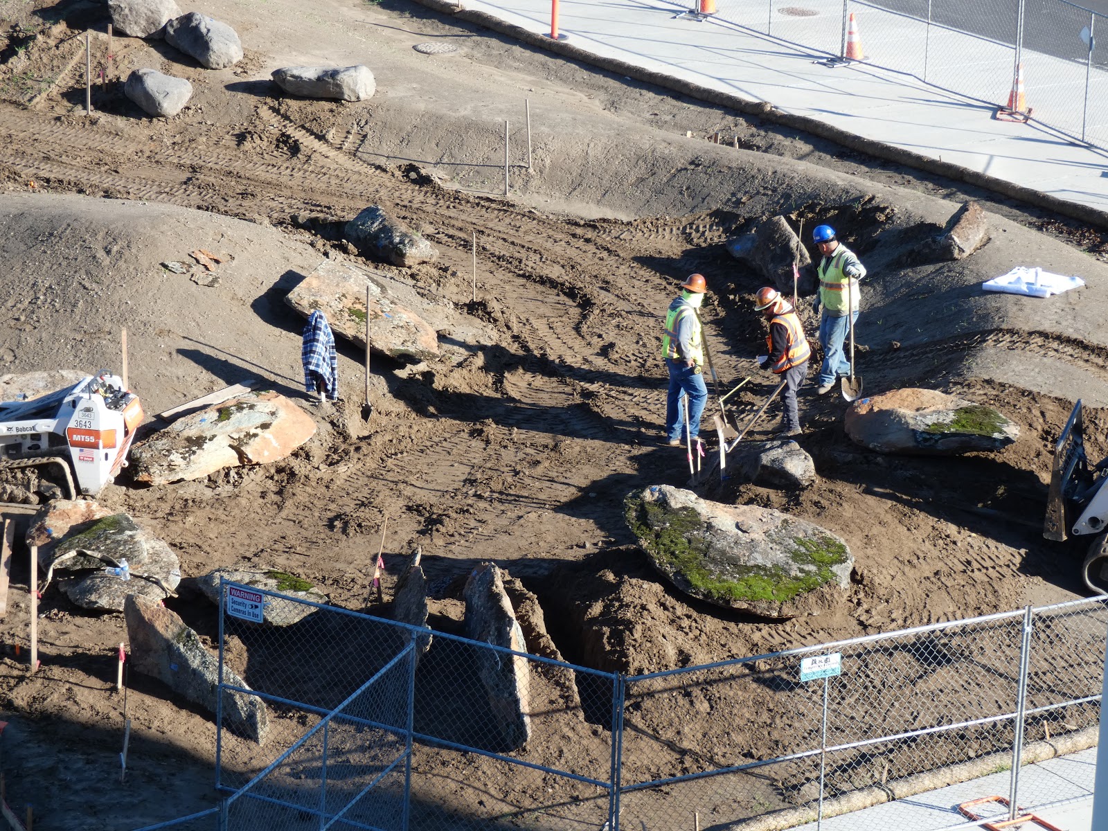
It's now safe to wander about a little, seeing what kind of rocks have germinated. I saw some tombstone rocks like those of the Mother Lode foothills, giant boulders of marble from the Calaveras Complex, and even a giant chunk of quartz, the ore-bearing rock of the Mother Lode gold veins. There were also some volcanic rocks from the Table Mountain Latite and the rhyolite tuff of the Valley Springs Formation. It's a great crop, which is good because no one is going to want to try moving these rocks once they've grown.
Finally you need the skilled rock farmers, who like bonsai tree tenders adjust the location of the boulders and plant some of them a little deeper so they won't fall over on anyone. And that's how you make a rock garden!

I understand that some of our botanists and biologists are intending to...um...plant plants on these beautiful rocks. I have mixed feelings about this, but they say it will enhance the education of the children who visit the museum every bit as much as the rocks will. I guess time will tell.

Things are happening pretty quickly now. Once the rocks are in place, the pathways will be put in and the planting will commence. It is actually just a few short months before our Great Valley Natural Outdoor Lab will be a reality. It's kind of interesting to compare the reality of the moment with a sketch I made during one of the early planning meetings:

Thursday, December 6, 2018

Wait a Minute...What Happened to the Rocks I Picked Out?

Something kind of extraordinary happened on campus this week. I was pausing between classes and saw a large truck and a crane downstairs in the staging area for the Great Valley Outdoor Nature Lab. The crane was dumping gigantic rocks onto the ground. "My" rock collection had arrived!! You might remember that early last month I went 'rock collecting' in the Sierra Nevada foothills for the rocks that will be part of the displays and landscaping of the outdoor. All 60 tons or so...
Source: https://media.giphy.com/media/12ScDYWbP4yoBq/giphy.gif
My response about their arrival on campus was predictable...

But if you remember the scene in "Elf" when Buddy thought Santa was in the store only to discover he was a fake, well, I had that moment too. I saw that something was off about the rocks I had selected. Something was different about them. Below was the rock that I selected a month ago, when it was 85 degrees out, and rain had not fallen in months...
And here (below) is the rock they claim I picked out. This after nearly two weeks of rain and cooler temperatures. This rock is clearly on a PALLET of LIES!

Well, okay, maybe it isn't on a pallet like the others, and maybe it is the same rock I picked out. But you can now see one of the main reasons I picked it, and why it will be sitting in a position of honor by the entrance sign to the outdoor nature lab. Not only is it a unique rock that is found in our region (the latite of Table Mountain), it is also a miniature ecosystem of mosses, lichens, grass, and other organisms. To see it, just add water!
In any case, we now have an astounding variety of the rocks that are found in our region. There is marble from the Calaveras Complex, the host rock of the many caverns that are found in the Sierra Nevada foothills.
There is a gigantic chunk of the quartz from the Mother Lode veins, the source of the gold that played such a huge (and devastating) part in the history of California. Sorry, no visible gold (although I'll keep looking).
One of the most striking rocks are the "tombstone rocks" of the Foothills Terrane, large fins of slate and phyllite that were once mud and silt on the ocean floor. The rocks were crushed against the western edge of North America, metamorphosed, and tilted vertically. We'll be putting them in the ground in the same vertical orientation. It will be a dramatic sight at the southern entrance to the lab.

The next step comes at the end of the week. I'll get to help direct the placement of the rocks! I'll try not to be insufferably picky..."Could you rotate that one about four inches? Great! Wait...I liked it better the way it was...". An update will follow.