Sunday, March 20, 2011

Predicting Earthquakes in California? I can do that too! I'll do it right now...

By golly, there is going to be an earthquake in California tomorrow! I'm going to go out on a limb and predict it. In fact, I will state unequivocally that there will be several earthquakes in California, some in the north state, and some in the south state. And I will be correct in my predictions. So, that should net me a few stories on the cable news networks, and a flood of tweets across the Internet by worried people who don't really believe it, but it could be true, you know....

What's my secret? There is no secret. California has earthquakes every day. We had 368 of them in the last week alone (368 quakes in a week is NOT unusual...sometimes there are more, sometimes there are less, but always there are hundreds). Check out the map below:
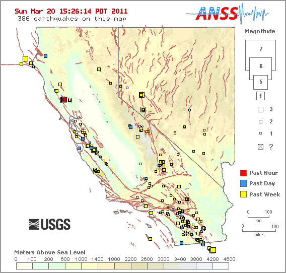
This blog was prompted by another flurry of requests from students and readers about someone somewhere predicting that we would have a big quake in California tomorrow; I won't provide links. They scare people needlessly, and it is irresponsible.

Anyone can predict quakes. But no one can predict large quakes with any kind of accuracy that will save lives. We can make long-term evaluations about the chances that a particular fault will rupture within a period of decades. But we can't predict big quakes a few days in advance. Anyone who says so is plain flat-out wrong. They will keep predicting quakes one after another, and one of these days, one of their hundreds of predictions will come true, and they will cash in.

I have a funny sense of deja vu, like we've been here before...

From my post of April 13, 2010:
8.4 Quake in California? Don't believe everything that Tweets...

No.

I should stop there, but I will say that no one can predict quakes in any useful way.

California's biggest quakes will be in the range of 7.8-8.0, quite a few times smaller than an 8.4. The stresses are there for a large quake to happen, but a magnitude 8 quake is given only a 4% chance of occurring sometime in the next 30 years.

Please don't believe everything that tweets....

But do prepare for quakes in California. They CAN happen any time, but NO ONE can predict them.

From my post of April 15, 2010:

8.4 Quake in California? Not so fast there, Twitterers...

If you have not read XKCD comics, you have been missing out on a great treat, especially if you are the scientific nerdy type of personality. On the heels of the Sierra El Mayor earthquake in Baja California, the comic above made the rounds, revealing a great truth: we are a wired, interconnected society (surprise!). Of course, there are the disadvantages as well.

So, to explain Tuesday's brief post: the XKCD comic above came true in a fashion...except there was no earthquake. I was checking my e-mails during a short break in my night class, and I had several people asking if the tweets they had received from friends were true, was the state of California declaring that an 8.4 magnitude quake would be hitting within the next 48 hours? Then I saw a few phones open up in class, and someone asked me directly about the Tweet on their phone. Clearly a rumor was spreading with the speed of electromagnetic energy and texting fingers. A hoax? An idiot crying 'fire' in a theatre? Undoubtedly. I posted my brief message explaining why the Tweet wasn't true, and had more than 2,000 hits in the space of 90 minutes. By the midnight, the 20th ranking query on Google was '8.4 magnitude earthquake in California'.

A lot of damage is done when rumors like this spread. No one can predict earthquakes, and a false prediction like this (or from 'psychics') can unnecessarily frighten people, and lead to a situation that will be perceived as crying 'Wolf'. People will stop paying attention to real warnings by qualified seismologists and vulcanologists.

We cannot predict earthquakes in such a way as to know the day, the week, or the month. We can use the history and prehistoric behaviour of fault zones to determine the possibility of a large quake within a time frame of decades. If you want a scientifically grounded prediction about earthquakes in California, check out the diagram below, from the Uniform California Earthquake Rupture Forecast (UCERF). The message to take away? Ignore the tweets, and pay attention to your personal emergency preparations. Quakes will happen.

Update #1: A nice explanation of why we can't predict big quakes can be found here.

Saturday, March 19, 2011

A Day in the Field...Day Backwards On Fun Having, Part One

Another day in the field...today it was our Geology Club. It's not enough that I make my students work hard in the classroom and lab, and drag them on field trip courses. The club members raised the funds to go out on their own and see something new and different. Once again the students led the teacher; I even rode in the back of the van! Yup, backwards day it was, in many different senses.

Strange as it may seem, I had, after twenty-two years in this region, never been to the top of what may arguably be the most famous geologic feature in our immediate vicinity. I've flown over it (a near-future blogpost), driven beneath it countless times, driven over it through a couple of erosional breaches, but I have never stood on top of it. So today I got to check off one more item on my life list: climbing the Stanislaus Table Mountain.

Things were backwards in a number of ways. We found the sweet spot between two powerful storms that are battering California this weekend. Yesterday there was so much snow that Highway 80 had a 45-car chain reaction accident and got closed in both directions. Right now the winds outside are gusting to frightening levels. But for four hours this morning the rain in the foothills let up, and we had a pleasant hike, aside from a bitter cold wind at the top. But instead of a normally hot and arid landscape, we had a muddy trail, rivulets of water everywhere, and waterfalls where waterfalls pretty much never happen (see above).
The trail to the summit starts at the end of Shell Road off of Rawhide Flat Road near the gold rush town of Columbia. "Summit" is not the best term though because Table Mountain is not a single peak at all. It is a flat-topped ridge that winds for many miles through the Sierra foothills. It is composed of a basalt-like volcanic rock called latite, and the lava flow displays some interesting columnar jointing in places (below). The flow is 9 or 10 million years old. How did it get to the top of the ridge? That question will be dealt with at a later time.
The trail crosses gently sloping meadows and oak woodlands for a mile, and then turns and climbs steeply for a half mile to the summit ridge. The ecosystem changes drastically as the trail climbs the north-facing slope. The path is shaded by numerous trees and shrubs, with some unexpected species for a region that regularly reaches 100 degrees in the summertime.

It's a thicket, really, and I'm glad we had a trail to follow instead of bushwacking. The poison oak would have been a real problem! In the picture below one can see the edge of the barren summit ridge.
We passed a glen full of ferns opening up for the first time among the brown husks of last year's crop.
The slope we were climbing was composed of large fallen boulders from the lava flow, a feature called a talus slope. The openings between the boulders can extend hundreds of feet into the slope, and cool moist air will seep out of the slopes all year long. Mosses cover the boulders.
I hope my flower-loving friends will identify the flower for me...I haven't noticed this species before (mind you, I'm a geologist, and flowers are as much a mystery to me as minerals are to botanists). It was fairly common and obvious on the shaded slopes.

We were nearly to the top, and had a close up view of yet another series of small ephemeral waterfalls. A few more switchbacks and we would reach the summit, the "top" of Table Mountain. Our backwards story will continue in the next post!

Friday, March 18, 2011

Shock Jocks Attack My Students: Who Serves Society Better?

So let's see. I have hundreds of students in my classes every year whose goal is to better themselves, and to work for the betterment of society. They are young students just out of high school who are seeking direction, they are single mothers trying to get off welfare and start working, they are newly jobless working to learn skills for a new career, they are retired people who want to learn something new. They have goals for their lives, and we are a pathway for them to achieve their goals. When I say they want to work for the betterment of society, I mean it. Among my many students are idealistic people who want to become police, nurses, firefighters, and teachers.

So, I get word that some shock jock radio guys named Ken and John at KFI Radio in Los Angeles think that community colleges are a scam, and that the students who attend are parasites.

Let's see what I remember from my core biology class at Chaffey Community College: A parasite is a creature that attaches itself to some kind of host, and draws its nourishment from the blood or organs of the host without giving anything in return. Parasites weaken and cause damage to the host organism. Tapeworms are an example of a parasite.

On the other hand, there are symbionts. In symbiosis, organisms also draw nourishment from their host, but they give something back. There is a mutual benefit in the relationship. Bees draw their nourishment from flowers, but in traveling from one flower to another, they pollinate and allow the plants to reproduce and flourish.

Which of these describe the students with whom I work every day? And what term describes ignorant radio hosts?

It seems that conservatives have long pushed the idea that people have to take personal responsibility for improving their lives. I've heard them say that people don't have the right of "equality" of resources (i.e. socialism), but that they should have equality of opportunity. I don't disagree with this. It is, in fact, why I teach. I want to give all my students the opportunity to succeed, and I work very hard to encourage them. And they work very hard to achieve their goals. Some fail. It happens. But many of them succeed against very long odds. I gain so much from my relationship with my students, and society benefits as they become qualified for better jobs and careers, especially in the fields where they help improve the lives of others. If you want to look at it from a purely economic point of view, educated people have better jobs, have more money to spend on products and services, and pay more in taxes.

Given that such radio personalities want to "shock" their audience and thus raise their ratings, well, it worked. I'm shocked, and I am paying attention to their advertisers. I don't think that these advertisers want to know what I think about them when they support people like Ken and John. I want all my readers to pay attention to these advertisers. And let them know about the kind of people they support with their advertising dollars. They will, by the way, never see a penny from me...

Here are the advertisers, from the website at KFI Radio (links on their website):

American Vision Windows

Auto Insurance Specialists

AT&T Wireless

Ayres Hotels

Cadillac

Covenant Debt Solutions

Cunning Dental Group

Intercap Lending

Jarvis & Krieger Attorneys at Law

Saddleback Eye Center

Susan's Healthy Gourmet

Warehouse Discount Center

By the way, the website of these same men has pictures of the Republican state senators and assembly people who are still negotiating on the budget with stakes through their heads and bird droppings on their head. Does such violent imagery have a place in our societal discourse? I hope you will consider contacting these legislators and tell them you support the community college system.

I am proud of my students. I am proud to be a teacher. I am proud to be part of the single largest system of higher education in the world with 2.7 million students, a system that trains 80% of our police and firefighters and 70% of our nurses. And I am appalled when people like Ken and John are given such a loud platform to spread their ignorance and hate. I would ignore them, but apparently they have one of the larger audiences in the south state.

People like Ken and John are the true parasites.

Thursday, March 17, 2011

A Day in the Field...Doing Geology in the Mother Lode

The state flower growing in the state rock next to a site where the state mineral was being mined...the only thing missing was the state mammal, and it's been missing for 80 years. On second thought, I would prefer not to have run into our state mammal anyway. It's the California grizzly, after all. I am talking about an early spring arrival California poppy growing in an exposure of serpentine along a fault in California's Mother Lode where gold was being mined from the 1850's through the 1930's. I was in the field last Saturday!

It's been an emotionally tough week. The sorrow and grief over the earthquake and tsunami in Japan, compounded by the ongoing meltdown at the Fukushima nuclear power plant has been bearing down on most of us. We face draconian budget cuts in our state educational system, and friends and fellow workers received layoff notices this week. Science is under attack at a time when it needs to be upheld as a way of working through serious and profound problems that face society in agriculture, energy and climate change. But the right questions aren't even being asked or discussed.

I have felt despair in so many ways. But like I said, I was in the field last Saturday, and I learned something. Teachers may think of their role as trying to inspire their students, but sometimes it's the other way around. The thirty students inspired me as they discovered some new things about their world. I wasn't dragging them around; they were pulling me...

We were exploring the southern Mother Lode between the Gold Rush towns of Mariposa and Jamestown, and learned how the gold was mined, how it formed, and a bit about the environmental devastation the mining caused. We got to collect the gold ore, quartz crystals, a rare chromium mica called mariposite, and pyrite. We also had a nice view up the Merced River towards Yosemite Valley! El Capitan is the steep cliff on the left, the tip of Half Dome appears just left of center, and Clouds Rest is the snowy peak behind El Cap.

We started at the dredge tailings around Snelling and Merced Falls. To get at microscopic bits of gold that had been carried down the rivers into the Central Valley, the mining companies dug holes down to the groundwater table, forming ponds in which they floated a factory ship that dug out one end of the pond, processed the sediments for gold, and dumped the waste on the other end. They worked their way across the landscape, ripping up the topsoil and leaving behind square miles of rockpiles. The land is mostly useless now, but it provided us an opportunity to identify the kinds of rocks that occur upstream, and which reveal something of Sierran history. There was quartzite (baked and pressurized beach sands), metavolcanic greenstone, slate, and occasional fragments of marble and granite. Three quarters of the rocks found in the Sierra are various types of granitic rock, but in the Mother Lode, the more ancient and more common metamorphic rocks tell a story of ancient shorelines, terrane collisions, volcanism and other activity. These rocks are far older than the granitic intrusions.
Later in the day we explored an abandoned gold mine (just the outside, mind you) where we found the most interesting minerals, and found the famous outcrop just west of Coulterville where we could see the minerals and rocks in their original arrangement. This stretch of the Mother Lode was relatively barren of gold, so the outcrop was not mined like so many others.
It was nice to see them discussing and exploring the outcrop! That doesn't always happen.
Our day included a stop at the California State Mining and Mineral Museum in Mariposa, where a great many spectacular specimens are on display. I photograph a different group of minerals every time I visit, and somehow I concentrated on the gold this time. The leafy gold above is a piece of a larger 44 lb nugget discovered at the Harvard Open Pit Mine just before it closed down in the 1990's (the big nugget is on display at the Ironstone Winery in Murphys, a bit farther north just off of Highway 49. Below is the Fricot Nugget, weighing in at 13 lbs. It's the biggest specimen on display, and one of the largest to survive the Gold Rush era without being melted down. If you are curious, the largest single specimen ever found in the state weighed just short of 200 lbs. It got melted down, but a replica is on display in the museum.
Strangely enough, the specimen I found most interesting was one of the smallest. We tend think of gold as nuggets that have been rolled in a stream and rounded off. We don't often think of gold crystals, but there it is below. Gold crystallizes in the isometric (cubic) system, but not generally as square cubes. The specimen below looks to be more like a dodecahedron.
Across from the mine site we took a brief excursion into the Earth's mantle, which is normally found many miles below the crust, but which been pushed up to the surface along a major fault system. Most of the mantle rock (peridotite)has been altered to serpentine, but we could find some chunks of mostly unaltered mantle material.

We ended the day with stops to look at the abandoned Harvard Open Pit Mine that operated in the 1980's and 1990's, and at Table Mountain near Jamestown, a famous example of an inverted stream. I may have more to say about it next week, since our geology club is intending to climb it this weekend (in the rain, probably).

All in all it was a good day, a brief respite from sorrow, and a day of being inspired by the enthusiasm of some great students.

Tuesday, March 15, 2011

The View of Japan's 9.0 Earthquake from Modesto, California, Part 2

The other day I provided a few screen shots of the seismic record that we captured in Modesto of the Sendai Earthquake in Japan. As I noted in that post, our seismometer is an old teaching model with deeply outmoded computer software, and all I was able to show were some screen shots. Well, I loaded the program on an older computer in the department, transferred the earthquake data to a floppy disk (remember those??), transferred the data onto a third computer where I could transfer the data to a CD-ROM, and finally was able to send the output to a printer. So today I offer the complete record. It's kind of astounding. The top picture is the initial minutes of the quake. You can see the amplitude of the waves rapidly increasing until they were off-scale. The notations on the left are the elapsed minutes, four minutes to the inch.

So what did the whole thing look like? At four minutes per inch, the print job took eight pages. I pasted them together and hung them on the wall, as seen below. This was a big earthquake, as if anyone needed to be told...

I Didn't Feel Like Teaching Today...

...but it was the kind of day that demands teaching.

My first day back with classes after the magnitude 9.0 quake and tsunami in Sendai, Japan, and the perfect teachable moment. Only it doesn't feel like a teachable moment. I just felt sorrow. So much is going on, and the situation seems to change hour to hour. First it was a magnitude 9.0 earthquake. Those don't happen very often, and that would be enough by itself to toss out the lesson plan of the day and discuss earthquakes and magnitude. But then there was the horrific tsunami that changed everything. 80 miles is a pretty good distance to be from a magnitude 9 quake, and it looks like the structures along Japan's coast weathered the shaking pretty well. But the tsunami raged through and erased towns, wiping them out of existence. Without the tsunami, the quake would have been a footnote. With the tsunami this event became the ultimate human tragedy. Thousands dead, hundreds of thousands homeless. It's hard to even speak of it, much less try and understand the pain and suffering that is taking place across the sea.

But then a new threat; the nuclear power stations began failing one after another in a story that is still unfolding. A human-induced tragedy superimposed over a nature event. We've concentrated radioactive substances in order to produce a form of energy, and the engineers have always told us that it can be made safe. Despite Three-Mile Island, despite Chernobyl, despite the other 30 'incidents' in the past 50 years. We've 'learned' from each of the accidents, it is said. They can't happen elsewhere. We have back up systems. We can't give up nuclear energy they say, because it is the bridge to a renewable energy future. Otherwise we'll have to burn more coal, and coal contributes to global warming. In all of the chattering among the talking heads on cable news this weekend, I have heard nothing of the threat of terrorism at nuclear power plants, nor have I heard anyone talk about where the highly radioactive waste is going to go. We've been avoiding the second problem for 50 years now. Will these questions start emerging, or will they disappear once the meltdown is complete, or once they stop the meltdown from occurring.

So the lesson plan for the day is tossed. We talk about the earthquake, the tsunami, the nuclear power plants. Questions, one after another. Some I can answer, some I cannot.

Can we have a magnitude 9 quake in California? Yes and no. The legendary San Andreas fault can produce events in the range of magnitude 8, about 1/30th of the size of the Sendai earthquake. Many other faults in California have produced dozens of quakes in the range of magnitude 6.5-7.5, and some have been very damaging. Magnitude 9? Not exactly. The Cascadia subduction zone lies off the coast of Northern California, and extends across Oregon and Washington. That system produced a magnitude 9 quake in 1700. Studies show such a quake takes place every few hundred years. Such a quake would have devastating consequences in NorCal and the Pacific Northwest.

Are the nuclear power plants going to have a full meltdown? I have no idea. I'm not an expert, and I don't know that the experts even know.

Will we be hit by a dangerous radioactive cloud? I don't think so, the experts say it will dissipate in the atmosphere and fall into the ocean before it gets here. I'm more worried about the people who live in the vicinity of the power plants. If the worst case scenario happens, the land they have lived on all their lives could be declared uninhabitable. Where will they go?

I'm glad the meltdown didn't happen here. How many of you know where your energy comes from? California has two operating nuclear power plants, both on the coast, both near fault systems. Another mothballed power plant sits unused just 80 miles from us, with all the fuel rods on site. The engineers for the plants say they're ready for whatever happens (I bite my tongue to avoid getting political).

Can a tsunami hit us in the Central Valley the way it did in Japan? No, not likely, but we have a different problem: the Sacramento Delta. The three dozen or so islands in the Delta are 'protected' by century-old levees that are prone to failure from causes as simple as excessive muskrat burrowing. The islands have sunk over the last century, and most are now below sea level. A moderate quake on nearby faults could cause widespread failure and flood the islands with seawater. If it were just lost farmlands, we could deal with it. But the intake pumps for the California Water Project are in the midst of the islands and the inundation could cut off the water supply for 20 million people for months, if not years.

What will the "Big One" do to us? It depends which "Big One" you are talking about. A repeat of the 1906 earthquake in San Francisco? Or the 1857 Fort Tejon earthquake? Or the 1872 Lone Pine quake Or another? All of them were close to magnitude 8, and if they happened again, the results would be profound. And there are dozens of other active fault zones in California. But here in the Central Valley? Harder to say. The 1906 quake was certainly felt in the region, but didn't do much damage in our town. Cities and towns on the west side of the valley will have some serious problems with shaking and liquefaction, but we are on relatively stable sediments.

Where's the best place to live? Kansas or Nebraska I should think. But watch out for tornadoes. Here in California, I would pick the Sierra foothills. Solid bedrock foundations and relatively far removed from the most active fault zones.

I have a question for the class: How many of you have an earthquake emergency kit ready at home (and in the car)? Two or three hands, including my own...

We are not ready...

Do you have questions? Use the comments section to ask and I will answer if I can, or find an answer somewhere.

Sunday, March 13, 2011

Why Geology is Important; Why Education is Important...The Sendai Earthquake in perspective

We learn about geology for many reasons. If you have ever visited this blog before, you know we learn geology because it is just plain fascinating. But sometimes we learn geology because lives are at stake...

It has been a week that will long seared into our collective memories as we watched a tragedy unfold in real time in Sendai, Japan. An earthquake of magnitude 8.9-9.0 struck about 80 miles offshore, with a horrific tsunami that did incalculable damage along the coast of the island. It then spread throughout the Pacific Basin, and the effects of the quake became worldwide in scope. Whether one realizes it or not, every human being on the planet was touched by the shaking. Not in some metaphysical new-age sense, but literally. The waves were detectable for hours on seismometers worldwide, meaning we were all rising and falling whether we were aware of it or not. We were all part of this story.

Many will watch an event like this unfold and try to find some meaning. In one sense, there was no meaning; this was something the Earth does. Subduction zones have been active on this planet for billions of years, and will continue to be active for billions more. The oceanic lithosphere shifted a few tens of feet deeper into the mantle, where it will eventually be melted or distorted beyond recognition. The materials disappearing from the surface today will eventually reappear, as part of a volcanic eruption, or as a fault sliver along some plate boundary in some future era. Events like this are common beyond measure; the Earth has experienced millions upon millions of huge earthquakes like this one, and though life is extinguished in some areas, life in general goes on. This quake meant nothing in the long run.

On the other hand, there was much about this tragedy that has meaning. With our brief life spans measured in decades, we will rarely experience such events in our personal lives. I could never wish such tragedy on anyone, but we also learn that living on this planet means that we are sometimes exposed to extreme deadly events. If not an earthquake, then a volcanic eruption. If not an eruption, a deadly flood. If not a flood, then a searing heat wave, or freezing blizzard. No one is totally safe or immune from these events, and most of the time we are not really aware that they can happen to us at all. They come as a total surprise.

In earlier centuries, such events elicited cosmic and supernatural explanations. It was the capricious nature of the gods that caused these terrible punishments. These people must have done something wrong to deserve such horrific retribution. If we couldn't think of an explanation, we made one up. I would love to say we have somehow moved on from this kind of thinking, but charlatans like Pat Robertson and others remind us constantly that ignorance and hate are alive and well in our society and across the world.

Why is geology important? Geology provides us with a new mythology of the world, one that based on a better understanding of the processes of our planet. We don't just see an earthquake happen on the surface and jump to the conclusion that the giant turtle that underlies our bit of land has taken a few steps. Instead we explored new pathways to knowledge that revealed that the earth itself is releasing energy to space, and that one of the ways that this happens is through the movement of lithospheric plates. Do we know the absolute truth? No, we don't. That's why we seek to learn more. We can now predict where earthquakes are likely to happen, but we cannot tell when, at least not well enough to save lives and property. If we are to live at the limits of sustainability on this planet, we need to know all we can about it.

Why is education important? Everyone has a right to know what geologic hazards may affect their lives. It should be a fundamental human right. It's not, but we can make the effort to make sure that people know what can happen, and help them to prepare for it. I live on a plate boundary, and a major earthquake is likely to strike close to my home. But I know from personal observation that people in California are shockingly unprepared for a major seismic event. Few have an emergency kit in their home, or a plan for what to do in the event of a major quake. Few people know the location of the legendary San Andreas fault, and even fewer can name any of the dozens of other active faults that exist in our state. We see the unfolding disaster of self-destructing nuclear power stations in Japan, and are mostly unaware that we have nuclear power plants along the California coast (there were even plans to build a nuclear plant directly on the San Andreas fault at Bodega Bay in the 1960s). We can't make people learn these things, but we've got to try, and we have to give our teachers and educators and media specialists adequate tools to do so. Recession or not, cutting back on education at all levels is a foolish idea.

Seers and psychics have always sought to see the future. They have used tea leaves or chicken entrails, and consumed hallucinatory drugs to achieve visions. Earth scientists use seismometers and supercomputers to model future activity along fault zones (and consume lots of coffee). They also make predictions in many other fields, including climatology, hydrology, and volcanology. Our society is living, as I said before, at the very limits of sustainability. We need to know when the quakes will happen. But even more importantly, we need to use the tools at our disposal to understand the changes that are happening in our climate. We need to fully understand the behaviour of ocean currents and cycles. We need to have a clear understanding of how much coal, gas and oil is left, and how the continued use of these fuel sources affects the climate. Recession or not, cutting back on basic research is a foolish idea.

Why the flower at the beginning of this post? I wasn't sure at first. I was in the field yesterday with my students, looking at California's Mother Lode. It's early for wildflowers, but a few were visible here and there. This was a beautiful Indian Paintbrush that seemed to be glowing in the sunlight. It occurred to me that the best flower displays in the Sierra foothills actually take place in the aftermath of forest fires. A disaster wipes out the old trees and tangled underbrush, but life springs back, and sometimes there is beauty. I guess I am hoping that some good can come of this disaster; that we might make some smart choices about where to go from here...

POSTSCRIPT: After posting this, it occurred to me that I forget to mention one more atrocity: media coverage. The cable and network news have abrogated their responsibility to produce responsible journalistic coverage in favor of spectacle and high ratings. They long ago let go their science advisors, and their news readers (and that's all they are anymore) have little or no education in the earth sciences. They have very little knowledge or expertise in geology, seismology, or climatology, and they continually make the same factual mistakes every time there is a new earthquake or other natural disaster. FOX, MSNBC, and CNN: your science coverage is an embarrassment to journalism.