Showing posts with label Mauna Loa. Show all posts

Friday, June 9, 2017

Volcanic Flows in Hawai'i: Life Finds a Way (to destroy rocks)

Ohi'a Lehua (Metrosideros polymorpha) clinging to a crack in a 1974 lava flow on Kilauea
I had kind of a schizophrenic (split-brain) response in regards to what I wanted to accomplish with this post. A couple of weeks ago while still in Hawai'i, I did a post on what I considered the ultimate wilderness on planet Earth, the nearly lifeless high-altitude basalt flows of Mauna Loa on the Big Island. At first, as a follow-up, I was thinking of the idea of how life finds a way to propagate even in the most barren settings. As I went along though, I started to think about how rock is destroyed, and how often life has something to do with the destruction. Whatever way this post decides to go, the unique Hawaiian tree Ohi'a Lehua (Metrosideros polymorpha) is going to have something to do with it.
Ohi'a Lehua (Metrosideros polymorpha). The trees are threatened by Rapid Ohia Death disease.

The Ohi'a is one of the most remarkable tree species on the planet. The Latin name polymorpha ('many shapes') provides a clue why: it can grow in a stunning number of deeply contrasting environments. Ohi'a trees can be found as the first pioneering species on fresh lava flows, as in the pictures above. They can be found on the near-desert leeward slopes of the island's volcanoes. They form the canopy of most of the island's rainforests, growing to heights approaching 100 feet (30 meters). They grow in near alpine conditions at 8,000-9,000 feet on Mauna Loa and Mauna Kea. And stunted trees, barely shrubs, survive in the high altitude bogs on Kauai where the rainfall exceeds 300 inches a year. I know of no other tree species that is capable of such feats.

It's true that you could try and cultivate Ohi'a trees in these kinds of environments elsewhere in the world and they might not do very well in competition with other established species. On Hawai'i, though, all they have to do is survive, because the isolation of the islands has meant that only a handful of other tree species ever arrived. So it is that in the unending battle between rock and life in Hawai'i, the Ohi'a tree is often the main combatant.

The Ohi'a trees aren't entirely alone as colonizers of barren landscapes in Hawai'i. The ʻŌhelo ʻai (Vaccinium reticulatum) is a shrub that can be found on new cinder cones, ash fields, lava flows and alpine slopes. The berry is edible, and is a treat for the nēnē, the native Hawaiian Goose. The geese in fact have a lot to do with spreading the seeds in the inhospitable environments of volcanic landscapes (they leave the seeds in their droppings). I'm trying to think of any other plant or shrub that produces mature fruit when it is only an inch or two high (as in the picture below).
ʻŌhelo ʻai (Vaccinium reticulatum)
There are a number of native fern species as well, growing in the most inhospitable environments I can imagine. Those below are growing in a pit on the flank of Mauna Ulu, which came into existence during a series of eruptions from 1969 to 1974.
And then there were the "furry rocks" I saw on Saddle Road at the pass between Mauna Loa and Mauna Kea. The mosses and lichens survive on the surface of the rock itself, and draw out nutrients directly from the minerals. The acids produced by the plants contribute to the alteration of the basalt to various clay minerals that end up producing pockets of soil that support numerous other plants. Forest succession eventually produces mature rainforests over time (at least with the cessation of constant lava flows as some of the volcanoes go dormant).
I guess "life finds a way" ended up as the predominate theme as I wrote. I was musing, though, about those high slopes of Mauna Loa at 11,000 feet where I saw no visible life. All the normal ways that rock is destroyed don't seem to apply up there. There are no plants to aid in the production of soil. There are no rivers to carry away sediment (any water seeps into the cracks and fractures of the lava flows and emerges far downslope). There are no glaciers. Snow falls on both Mauna Loa and Mauna Kea, and there were glaciers thousands of years ago, but they have little influence in the present day (one of the talks at the conference I attended concerned the permafrost at the summit of Mauna Kea). Waves can't attack the rocks until the islands have subsided enough, a process taking millions of years. Mass wasting has little effect on the gentle slopes of the giant shields, although gigantic megaslides eventually destroy the flanks of the volcanoes and ultimately lead to their destruction. The barren lava fields on the high flanks of Mauna Loa seem permanent until one realizes that they will no doubt be covered by new lava flows in a matter of decades or centuries. And when the volcano goes dormant or extinct, time (and life) will indeed destroy the rocks.
Life creeps ever higher towards the barren summit of Mauna Kea


Wednesday, May 24, 2017

A Flight Around the World's Highest Mountains: Mauna Kea and Mauna Loa


Mountains that make their own weather can be frustrating because...they make their own weather. High mountains in the path of consistent winds force air masses upwards, causing the water vapor within to condense, forming clouds and as often as not, rain. This is especially true around the tallest mountains on the planet.


I'm not talking about Mt. Everest in the Himalayas. It's tall of course, just over 29,000 feet above sea level. But if one measures from the base of the mountain on the sea floor, Mauna Loa and Mauna Kea on the Big Island of Hawai'i are around 32,000 feet high (Mauna Kea edges out Mauna Loa by about 120 feet). The two giants are nearly 14,000 feet above sea level, and they rise in the middle of the northeast Trade Winds of the Pacific Ocean. They are often clear for a few minutes in the early morning, but the clouds can build quickly, obscuring the view. During our field studies trip in 2016, we had been exploring for five days before the students even saw Mauna Loa at all.
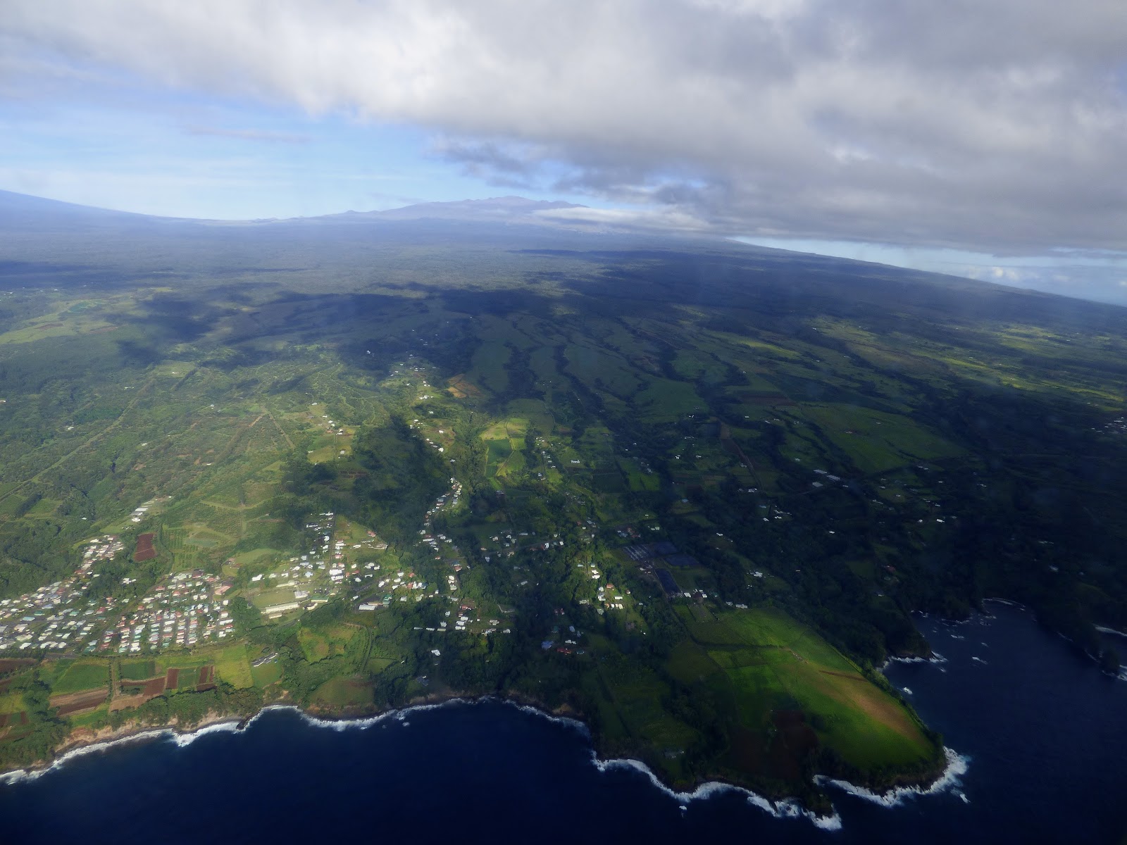
I've been privileged to visit the Hawaiian Islands eight times now, and that means there've been a few chances to see the great shield volcanoes from above as I've arrived or departed from the islands, but none of them was like the scene that presented itself to me this morning. We had an early flight, and for once I was on the correct side of the plane (for the record, on flights out of Hilo you want to be on the left side of the plane). There were just a few clouds on the northeast side, but we flew through them and soon the entire north flank of Mauna Kea was spread out below.
These mountains are astoundingly big. They formed from hundreds of thousands of eruptions of non-viscous (easily flowing) streams of basaltic lava generated at a "hot spot" in the earth's mantle hundreds of miles beneath the surface. The outer lithosphere of the earth slides over the hot spot, carrying earlier-formed volcanoes to the northwest. Kauai, Maui, and Oahu were all once large shield volcanoes like Mauna Kea and Mauna Loa, but they have subsided and erosion has ripped into their flanks. Mauna Kea and Mauna Loa will eventually suffer the same fate, and in fact Mauna Kea hasn't erupted in several thousand years (a number of very expensive telescope dot its summit). Mauna Loa is still highly active, having erupted in 1984. I wouldn't be shocked if it erupted again tomorrow (which would be the karma of just having left the island).
Perhaps my favorite shot of all, the north flank of Mauna Kea
These mountains aren't just fascinating as geological entities. They are also biological refuges. There are hundreds if not thousands of rare and endemic species of plants and animals in the forests on the flanks of the mountains. There are few environments like these on the planet, a slope that climbs from beaches to tropical rainforests, temperate rainforests, high deserts, and alpine slopes. One can see from the patchwork of cleared forests on the flanks of the volcanoes that we have severely affected these unique environments in order to raise cattle and goats. Many species, especially birds, have been lost, and other are barely hanging on.
Three gigantic shields in one picture, Mauna Kea on the left, Mauna Loa in the center, and Hualapai on the right.

It was a fascinating flight around the summits of the world's highest mountains!

Sunday, May 21, 2017

The Most Desolate Place in the United States? The Mauna Loa Weather Observatory

If I seem to be missing in action, it would be because I've been stuck on planes and in airports on my way to the conference and field trips of the Cordilleran Section of the Geological Society of America. Just my luck that they happen to be meeting in Hawai'i this year. I mean really, it's my luck! I am so happy to be back on the islands. We had a spare day, so we did a bit of exploring, finding our way up Saddle Road and driving to the Mauna Loa Weather Observatory, which among other things has been measuring the carbon dioxide content of our atmosphere since the 1950s.
This picture is not tilted. That's the upper slope of Mauna Loa
This post is a bit different than some. It may usually seem that I am encouraging you to visit the places that I write about, but that's not necessarily the case today. Today's destination is something you really have to want to do. Why? Because it could quite possibly be the most desolate place in the United States. It's the road reaches the 11,000 foot level of Hawaii's biggest volcano. And it's no tourist destination. There are no facilities. You can't even visit the observatory itself. It's off limits. But if you want to see a landscape that may be the closest analog on Earth to a place like Mars, this may be the place.
The road begins near the summit of Saddle Road between Mauna Loa and Mauna Kea. Most visitors head north up Mauna Kea to the Onizuka Center for Astronomical Studies. It has bathrooms, a gift shop, telescope viewing at night and grand vistas by day. It's a welcoming place. And it's only a six mile drive. If you go south towards the Observatory, the single lane road travels 17 miles, and at about the 10,000 foot level, you leave all earthly life behind (at least it is well hidden). These are lava flows, many if not most less than a century old, and what life is possible at 11,000 feet keeps getting extinguished by hot lava. It is as desolate a place as I have ever seen.

Would you want to visit this barren blasted place? Perhaps. It depends on what you want to get out of a visit to the islands. If you are in stellar shape, the road's end is a trailhead for the shortest hiking access to the top of Mauna Loa nearly 3,000 feet higher (about 3.8 miles to the summit ridge and another 3 or so to the actual summit). It's a case of instant altitude sickness just waiting to happen. If you want to see one of the most unearthly places on Earth, it may be worth your time. If you haven't seen the important parts of Hawai'i Volcanoes National Park, then your precious time might be better spent on the south side of the gigantic mountain.

Speaking for myself, I was fascinated the whole way.

Tuesday, August 23, 2016

The Hawai'i That Was: Watching the Destruction of the Islands in Real Time

The Big Island volcanoes of Mauna Kea (left) and Mauna Loa (right), as seen from the summit of Haleakala on Maui

Geologists have at their fingertips the closest thing to a working time machine that exists on planet Earth. We can't travel to the past, of course, but we can decipher past happenings by working out the sequence of geological events. But with the Hawaiian Islands, we have a different kind of time machine. We can predict the future of the Big Island.

The Hawaiian Islands are an example of an active hot spot, an enigmatic place in the Earth's mantle that is much hotter than surrounding regions. The hot spots produce tremendous amounts of basaltic lava that erupt onto the ocean floor, and the constant eruptions result in the formation of the gigantic shields like Mauna Loa and Mauna Kea (top picture). Since the asthenosphere (solid upper mantle and crust) is in constant lateral motion, the volcanoes that grow on the hot spots are carried off, and ultimately become inactive. The former hot spot volcanoes don't end with Kauai and Ni'ihau. There are submerged former islands on the Pacific Ocean floor that extend all the way to the Aleutian Islands in Alaska. In the history of these islands and former islands we see the future of the Big Island of Hawai'i. It will be a history of destruction and loss.
Haleakala on the island of Maui
The Big Island is larger than all of the other main Hawaiian Islands combined. As has been mentioned in the previous posts on the the Hawai'i That Was, the island is composed of five distinct shield volcanoes, Kilauea, Mauna Loa, Mauna Kea, Hualalai, and Kohala. As one flies to Kaua'i, as we did during our recent trip, we passed each of these smaller islands, some well known, others not. They include popular Maui and Molokai, as well as Lana'i and Kaho'olawe.

Maui (above) includes two shield volcanoes, the immense Haleakala (10,023 ft - 3,055 m), and the lesser known West Maui volcano (5,788 ft - 1,764 m). A low valley separates the two volcanoes. Some might ask why there are only two volcanoes and not five, like on the Big Island. Why, indeed?
South side of Moloka'i
Moloka'i is likewise made up of two volcanoes, although the linear nature of the island hardly suggests any kind of volcano shape at all. The entire north side of the island is one continuous high cliff that originated when the half of the volcano slid into the sea in a gigantic debris avalanche. Another island composed of two volcanoes. Why is that?
North side of Moloka'i (I haven't been there so we have an aerial photo instead).
The island of Lana'i is what remains of a single volcano. The uninhabited island of Kaho'olawe is likewise the remains of an isolated shield. So what's with all of these small islands composed of one or two volcanoes, instead of a large single island like the Big Island of Hawai'i? An answer is to be found with a map of the islands that also shows the submarine geology
Lana'i
The four islands, Maui, Moloka'i, Lana'i, and Kaho'olawe, are spaced about as far apart from each other as the peaks on the Big Island. The intervening seas are very shallow, and one soon realizes that Mau'i and the other islands were in fact once a single island similar in size to the Big Island. The islands have been sinking slowly as they press down on the underlying crust and mantle. They were interconnected as recently as the last ice age.
So, on our flight from the Big Island to Kaua'i, we see the future of the Big Island of Hawai'i. As the volcanoes subside (measurements at Hilo suggest about an inch per decade), the single island will become a series of isolated islands. Erosion will tear away at their flanks, and gigantic avalanches will tear away large portions, spreading the debris across the deep ocean floor. What's nice about this? The degraded and eroded masses of rock in the islands of Hawai'i have turned out to be some of the most beautiful landscapes on the planet! In the next post, we'll arrive at the most eroded island of all, Kaua'i (our recent trip only covered the two islands; I may take up an exploration of Oahu and Maui later on).

Tuesday, June 28, 2016

The Hawai'i That Was: How Can the Biggest Mountain in the World Stay So Hidden?

Mauna Loa from the Mauna Kea Road near the Onizuka Center
The answer is easy: clouds. This whole post is a temper tantrum, a tantrum that resulted from the fact that we were on the Big Island of Hawai'i, the site of the biggest mountain on planet Earth, for nine days a few weeks ago. Despite repeated opportunities, my students never had a clear view of Mauna Loa, the volcano that covers more than half of the island. It was a rainy stretch of weather, so the best we ever got were brief peeks, kind of like watching an old-fashioned feather boa dance. So in response, I've drawn from the Geotripper archives to find pictures of Mauna Loa from earlier trips. Very sunny trips.
Mauna Loa from the Mauna Kea Road near the Onizuka Center

Clouds are not the least bit unusual on the slopes of Mauna Loa and Mauna Kea, the two highest peaks on the planet (as measured from the sea floor; of the two, Mauna Kea is slightly higher). The Hawaiian Islands lie in the path of the trade winds most of the year, and as the moist air masses rise against the gentle slopes of the massive shields, they cool and condense into clouds. Hilo is pretty much the wettest city in the United States, with more than 100 inches of rain each year. Oddly enough, an atmospheric inversion layer limits cloud formation to the lower slopes of the volcanoes. It's been more than once that I've left Hilo in a rainstorm only to find crystal clear skies up on the mountain (but not so much last week!). Exceptions, like earlier this month, happen when storm fronts come through. In winter, snow is not a rare occurrence on the high peaks.
Mauna Loa from the Mauna Kea Road above the Onizuka Center
Oceans have a lot to do with the fact that no one gets to see the entirety of Mauna Loa. It is the biggest mountain on the planet, as well as the biggest volcano (although the Tamu Massif may be more voluminous), but it rises of the floor of the Pacific Ocean, with around 17,000 feet hidden beneath sea level.  A bit less than 14,000 feet rises above the waves. It depresses the sea floor another five miles, so the mountain could actually be said to be 56,000 feet high. It has a volume of 15,000-19,000 cubic miles.
Sunset on Mauna Loa from Mauna Kea. The brown air is vog from the eruptions at Kilauea on the other side of the mountain.
The volcano began erupting perhaps 700,000 years ago, and became an island around 400,000 years ago. It's hard to confirm since the older lava flows are hidden deep beneath the younger ones. The oldest exposed lavas (at the Ninole Hills) are about 200,000 years old. The giant shield continues to be very active, with 33 eruptions since 1843. The last eruption was in 1984, making this quiescent period the longest in recorded history (contrast that with the continuous eruptions at nearby Kilauea that started in 1983). The lava from the 1984 eruption came uncomfortably close to Hilo.
Mauna Loa from South Point, the imaginatively named southernmost point in the United States.
The gentle slopes of the volcano belie the true immensity of the mountain. To hike from the shoreline to summit is to simulate a trip from the tropics to the Arctic Circle. The slopes above 4,000 feet are among the most important bird habitat in the nation. Hawai'i is a gigantic open laboratory of evolution and the many native species have been decimated by environmental disruptions caused by the arrival of humans and their pigs, goats, rats, and mongooses. Even worse was the arrival of mosquitoes in the 1870s, as they are a vector for transmitting avian malaria. The native birds had no immunity. The mosquitoes can't thrive in the cooler conditions above 4,000 feet, so the mountains are an island within an island, providing sanctuary for the remaining survivors.
Mauna Loa looks almost insignificant in the morning light from Hilo Bay (below), but the summit is around forty miles away. The mountain is gigantic, and dangerous. And we barely got to see it earlier this month. But we knew it was there. We were surrounded by its flows in Hilo, at Hawai'i Volcanoes National Park, at South Point, and at Kona, a drive that took us 120 miles!
Mauna Loa from Hilo Bay

Wednesday, June 1, 2016

A Most Misunderstood Island: One of the Most Diverse Landscapes on Earth

Shall we start with a stereotypical Hawaiian beach?
One can certainly be forgiven for thinking that Hawai'i is a group of high-rise hotels next to a wide sandy beach. It isn't as if a string of television shows (Magnum, P.I. and Hawaii 5-0 for example) have spent decades putting that stereotype into our heads. And the majority of tourists never venture beyond the hotel row at Waikiki and Honolulu. A visit to some of the other islands can be a real revelation (and adventure). The Hawaiian Islands, and especially the Big Island, are one of the most diverse landscapes on planet Earth.
The view from Pu'u Huluhulu at Saddle Road summit

Not convinced? Here is a selection of pictures taken over just two days of reconnaissance on the Big Island. How about an African savanna? A lone Koa tree (I think, I'm still learning these!) overlooks the plains along the summit of Saddle Road, a highway that links the two sides of the island. There are even grazing cattle, sheep, pigs, and goats (which are doing terrible things to the natural ecosystems).

Perhaps an archaeological site in the wilds of the Sinai Desert? The great heiaus on the Big Island served a variety of purposes, including refuges, sacrificial sites, and temples. They date back hundreds of years. This one can be seen at Pu'ukohola Heiau National Historical Site on the dry side of the island in the rain shadow of the Kohala volcano. Rainfall averages less than 20 inches a year, compared to more than a hundred just a few miles away.

A recovering mesic coastal forest? Not a desert, not a rainforest, but somewhere in-between (mostly on the dry side) We are looking at the Lapakahi State Historical Park on the west slope of Kohala. The original forest was cut down for a number of reasons, but humans lived in this village for hundreds of years.

How about the high plains prairie? One of the largest privately owned ranches in the United States is found on the Big Island (the Parker Ranch). The cattle graze on rich grasslands that cover some of the older volcanoes. When they reach the right age, they fly in a 747 to the mainland. As a guide to Hawaii mentions, they probably enjoy more foot room than the average tourist in coach...

 As can be seen, some of the grasslands are windy.

Big Sur on the Big Island? Sure. This Big Island is not as famed for the coastal cliffs like those in Kaua'i and Molokai, but several tens of thousands of years ago, a large part of the northern coastline of the island collapsed into the sea. It probably produced a mega-tsunami in the local islands that had run-ups amounting to hundreds of feet in elevation.The Pololu Valley and coast is stunning.
The Pololu coast is also known for the gorgeous river valleys that extend into the Kohala volcano ("gorgeous"; Did you get it?). The canyons are hundreds of feet deep, and were once even deeper, but the islands are slowly sinking and the valleys fill with sediment.

I doubt that Sauron would have ever established Mordor in a place like this. These a'a lava flows from Mauna Loa are only a few decades old, and are practically impossible to traverse. Somehow a highway got built across part of it, and there is even a strange housing complex in the immediate vicinity. The few trees are the native Ohi'a, a tree that can grow from coastal environments to as high as 10,000 feet or so. I don't believe there is another tree on the planet that can do that.

And how about glacial environments? Yes, Hawai'i had glaciers during the Ice Ages! The top of Mauna Kea was mantled with flowing ice only a few thousand years ago. There are glacial moraines, and even a small lake that is the third highest in United States. Eruptions happening in the ice produced a glassy form of basalt that was much harder than normal, so the native Hawaiians would climb to the summit of the mountain to gather the rock for tool-making.

And finally, yes, there are rainforests! Beautiful green forests filled with rare and endemic plants found nowhere else on the planet. Don't tell anyone about this, but I see scenes like this and think of the Jungle Cruise at Disneyland! But these forests are real.

There are even more ecosystems and biomes on the island that we just didn't happen to see on our short excursions. Expect to see some more as the week progresses. We've got two more weeks on the islands, and lots of exploring to do!

Sunday, October 25, 2015

Picture Yourself Here: Multidisciplinary Field Studies in the Hawaiian Islands, June 1-13, 2016

This might be of interest only to my Modesto area readers, but anyone who is interested in learning about the natural and human history of the Hawaiian Islands may want to investigate this field studies opportunity June 1-13, 2016. I am collaborating with anthropologist Dr. Susan Kerr of Modesto Junior College to guide students on an exploration of two of the most fascinating islands in the Pacific Ocean, Hawai'i (the Big Island), and Kaua'i.
The islands are an outstanding outdoor laboratory for understanding basaltic volcanism associated with a "hot spot", or mantle plume. The Big Island consists of five overlapping shield volcanoes, including the largest and highest mountains on the planet, Mauna Loa and Mauna Kea. Measured from their base on the ocean floor, the volcanoes are more than 30,000 feet tall. The portion that rises above sea level is impressive. It is possible to collect snow from the summits during part of the year. Glaciers once collected on the summit of Mauna Kea!
Although we couldn't possibly guarantee lava on our trip, Kilauea has been producing lava flows nonstop for more than thirty years. Subsurface activity has been noted for the last few weeks at Mauna Loa. It hasn't erupted since 1984, but who knows?

Of course, volcanism is hardly the only fascinating topic of study in the Hawaiian Islands. There are tropical jungles and deserts is well as the iconic beaches (including a green sand beach, the sand grains composed of the mineral olivine!). There are striking examples of evolution in action, with highly adapted plant and animals species, including a group of native Honeycreepers that are (or were) as diverse as Darwin's finches on the Galapagos Islands. There are even native owls, hawks, and geese (the Nene is the state bird; some Canada Geese made a wrong turn a half million years ago).

The human story is no less compelling, from the arrival of Polynesians hundreds of years ago to the later mingling of cultures that make the state one of the most diverse human communities on the planet.
We will spend about nine days on the Big Island, working out of hotels in Hilo and Kona. We'll then fly to Kaua'i to spend four days exploring the small, older island, including overlooks of the legendary Na Pali Coast, and the "Grand Canyon of the Pacific", the incredible Waimea Canyon. Although the itinerary is ambitious, we will work time in for some optional personal explorations, including possible hikes into Waimea Canyon, or onto the Alaka'i Swamp, one of the strangest environments on the planet (the swamps receive hundreds of inches of rain every year).

The cost of the classes will be $2,200 for lodging, transportation, and fees. Participants will need to pay their fare to and from the islands, and provide their own food (the fee includes the inter-island flight). The students will enroll in Geology 190 and Anthropology 190 (through Modesto Junior College). There are no prerequisites, although previous courses in geology or anthropology certainly wouldn't hurt. The tuition will be about $300 (unfortunately the out-of-state tuition is considerably higher)..
We are having an organizational meeting on Friday, October 30 on the West Campus of Modesto Junior College at 7PM in Science Community Center Room 326. Attendance is not mandatory and brochures will be available for those who can't make it. Initial deposits will be due in mid-November, and priority space will be given to the first twenty students who commit to the trip. If there are more than twenty, we will try to accommodate them if possible.

For information and announcements, please check out the class web page at http://hayesg.faculty.mjc.edu/Hawaii_2016.html, or join the Hawaii field studies Facebook group at https://www.facebook.com/groups/452708258272005/. We hope you'll consider joining us on this once in a lifetime opportunity! Please contact me at hayesg (at) mjc.edu if you have questions.

Sunday, August 22, 2010

Dispatches from the Road: Excuse me, there's a Kao trying to get into your Kipuka Pu'u Huluhulu...

It's hard to imagine a more spectacular setting than Saddle Road Summit on the Big Island of Hawai'i. Two of the world's largest volcanoes, Mauna Kea and Mauna Loa, overlap at an elevation of almost 7,000 feet. In the middle of the broad pass, with expansive views of both volcanoes, there is one of the most extraordinary sights of all the islands: Pu'u Huluhulu. The name means "shaggy hill". It's a small knob, a minor cinder cone lying between two giants, but it tells a fascinating story. The cinder cone erupted several thousand years ago, and has since been surrounded by barren basalt flows, most recently in the 1930s. These isolated areas surrounded by fresh lava flows are called kipukas.
On islands that have been ravaged by invasive species the way Hawai'i has, kipukas serve as islands within islands. They can preserve a native landscape that has disappeared from most of the rest of the islands. At Pu'u Huluhulu, the slopes preserve a Koa tree forest environment that once covered most of Mauna Kea, but which was decimated by logging and grazing over the last 150 years. If and when we decide to change our land-use practices on the islands, a kipuka like this one can be the source of native species that could eventually lead to the reforestation of the mountains.

Koa trees, like those seen above on the trail around Pu'u Huluhulu, once grew in abundance on the islands, reaching upwards of a hundred feet tall, and trunks wide enough to fashion canoes. Most of the "grandfather" trees have been cut down, so a place like this, with a Koa forest environment, is all the more valuable.

One cannot mistake this place as a pristine environment, though. The area was grazed heavily over the years and invasive weeds arrived on boots, and on the fur of goats, cows and pigs. The pigs and goats were especially destructive of the understory shrubs. What has changed is the growing recognition of the value of such places. A fence has been constructed to keep out the goats and pigs, and volunteers have been weeding out the invasive plant species, and planting, or encouraging the growth of dormant seeds of the native understory shrubs and perennials. They're doing a good job. The native vegetation attracts native bird and insect species, and Pu'u Huluhulu is often a good place to see the native Amakihi, Apanane, Io (Hawaiian hawk), Pueo (Hawaiian owl), Nene (the Hawaiian goose), I'iwi and other unique birds. We heard, but didn't see any close enough to photograph on this trip, but I'll be back!
We did see a rather incongruous sight, though: a herd of goats wandering across the barren lava fields (that's the "kao" of the blog title today). They know very well what lies across the fence, and they literally hang around the gateways in the fencing, hoping for a chance to get into the kipuka and do their thing, which is eating and eating. When they say "close the gates", please do it! There is grazing land across the highway for the goats.

If you have old memories of Saddle Road as a hellish, dangerous winding mountain road, or if you visit for the first time and read that the road is not for the faint of heart, the situation (for better or worse in the philosophical sense) has changed. The road has been repaved and engineered, and is a pleasant drive, if it isn't raining or foggy. Some people miss the wildness of the old route, which was pretty unnerving when I followed it for the first time. The expansive views, especially on the western slope on clear days, are stunning. It's a purely Hawaiian experience, but not a Hawai'i stereotype. There really isn't any place like this in the world.

Next time: a different kipuka...